Journal of Geoscience and Environment Protection
Vol.04 No.01(2016), Article ID:62721,7 pages
10.4236/gep.2016.41009
Hydrological Modelling of Sidi Jabeur Watershed (Morocco) Using Spatially Distributed Model ATHYS
Mourad Khattati1*, Mostapha Serroukh1, Ismail Rafik1, Hakim Mesmoudi1, Brirhet Hassane2, Yassine Bouslihim3
1Research Team ERGO, Faculty of Science, Abdelmalek Essaadi University, Tetouan, Morocco
2Faculty of Science and Technology, Sidi Mohammed Ben Abdellah University, Fes, Morocco
3Faculty of Science and Technology, 1st Hassan University, Settat, Morocco

Copyright © 2016 by authors and Scientific Research Publishing Inc.
This work is licensed under the Creative Commons Attribution International License (CC BY).
http://creativecommons.org/licenses/by/4.0/


Received 21 October 2015; accepted 10 January 2016; published 13 January 2016
ABSTRACT
The objective of this study is to model the hydrology in the Sidi Jabeur basin, located in Bouregreg watershed at the north-central of Morocco, using the spatially distributed model (ATHYS) in order to understand and determine the different watershed hydrological processes. The study requires the collection of a series of data as inputs models namely rainfall data, water quantity, soil occupation, digital terrain model and requires also a calibration in order to evaluate the model in validation phase. The simulation results are obtained from the validation phase aim to replicate the operation of Sidi Jabeur watershed, and present a suitable adjustment perspective of the observed hydrograph. These results show that the objective is achieved and a model distributed like ATHYS plays an effective role in improving the efficiency and presents a high advantage in anticipation of runoff volume.
Keywords:
Distributed Model, Hydrology, Sidi Jabeur Watershed, ATHYS

1. Introduction
The water is the most important natural resource especially in the arid or semi-arid zones that face high population growth, scarcity of freshwater, irregularity of rainfall, excessive land use change and increasing vulnerability to risks such of drought, desertification and pollution. Thus, the availability and the sustainable use of this resource become the core of the local and national strategies and politics in these regions [1] .
Managing water resources are mostly required at watershed scale [2] given that is the basic hydrologic unit where can be studied the heterogeneity and complexity of processes and interactions linking land surface, climatic factors and human activities [1] . This adopted approach for assessing water quantity and quality is then expressed as various hydrologic models and tools that try to simulate and predict the watershed response at different spatial and time scales.
The objective of this study is to model the dynamics of Sidi Jabeur watershed functioning with the reconstitution of river flow at outlet (Station Sidi Jabeur). The simulation of water intake in the hydrological station has been done with the use of a spatially distributed model ATHYS. However, the objective is to test the adaptability and ensures a good performance of the model. In this work, the time step of modeling is daily, this choice due to compare modeled flows with occasional discharge measurements on the hydrometric Sidi Jabeur station.
2. Materials and Methods
2.1. Study Area
Sidi Jabeur basin is located at the south of the Bouregreg watershed north-central of Morocco (Figure 1). The watershed covers an area of 2910 km2 with an elevation ranging from 1602 m to 330 m (Sidi Jabeur outlet).
Between 1977-2005, the minimum annual rainfall is 288 mm/year in Ouljet Haboub station, while the maximum is 300 mm/year in Sidi Jabeur station. Furthermore, the annual and monthly average is respectively 294 mm and 28 mm (Figure 2).
2.2. Presentation of ATHYS Model
ATHYS (A Telier Hydrologique Spatialisé) is rainfall-runoff transformation model, developed by the Research Institute for Development (IRD) of Montpellier. The basic principles of ATHYS are a hydrological environment for distributed modeling, including a series of models, DEM processing, hydrological and rainfall data and geographical display, spatial data interpolation. The flow generated for a rain event (rainfall-runoff transformation)

Figure 1. Map situation of Sidi Jabeur watershed.
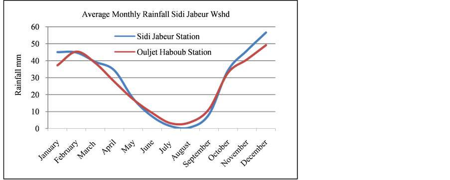
Figure 2. Average monthly rainfall in Sidi Jabeur watershed.
is calculated for each cell, the amount of rain is estimated by the production model which will contribute to runoff. The transfer model calculate the hydrograph produced by each watershed outlet, this calculation is made from the result obtained under the production function.
2.3. Methodology and Data Processing
The spatially distributed model ATHYS are used to simulate the flow rates daily time in Sidi Jabeur station from 1996 to 2004. The calibration and validation period is respectively 1996-1999 and 2000-2004. To estimate the parameters of production and transfer models, a manual procedure by the sensitivity analysis had been used. From input data (digital terrain model, precipitation), the hydrological model ATHYS is used to define the daily runoff flow for each cells of Sidi Jabeur watershed, and also to obtain the drainage network, slope classes… etc. From the effective rainfall, SCS function defines the runoff depth. Moreover, unit hydrograph transfer function calculates the flows for each sub basins outlet, identified as nodes calculation (Ouljet Haboub and Sidi Jabeur). The DEM used is a set of elevation points (three coordinates, x, y and z) located every 90 m. The topography is reconstructed by the assembly of these points (Figure 3). The sub-mentioned data help to define the drainage network, slope classes (Figure 4), drainage directions (Figure 5), sub basins (Figure 6).
In this study, three different production classes have been identified from the topography (slopes), as a file reclassified between 447 classes of natural slopes. Low and middle runoff zone correspond to the plains with slopes from 0 to 200 m/km, while the high runoff zone corresponds to the high slopes mainly on reliefs.
Climatologically information is accurately known in each station. This information must be spatially on the catchment area. The method of Thiessen polygons was used to define the influence’s area for each station (Ta- ble 1).
The following table shows the breakdown of the areas of Sidi Jabeur watershed based in the production classes (Table 2).
The area of high runoff concerns only 5.15% of the whole watershed area. This area corresponds to the reliefs with bare soil (and/or) with high slopes.
To evaluate our model three statistic coefficients were adopted: Coefficients of Determination (R2), Nash- Sutcliffe efficiency coefficient (NSE) [3] , and RMSE-observations standard deviation ratio (RSR) [4] . The formulas of these coefficients are given in the following equations.
 (1)
(1)
 (2)
(2)
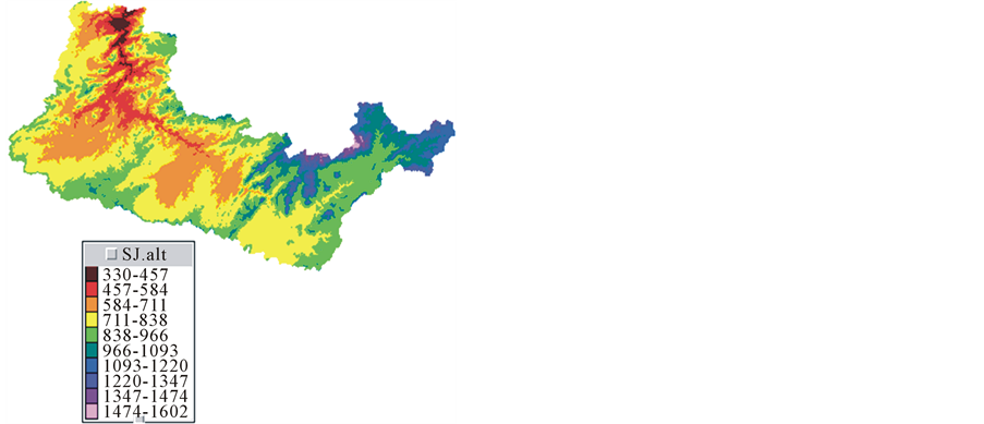
Figure 3. Map of altitudes.
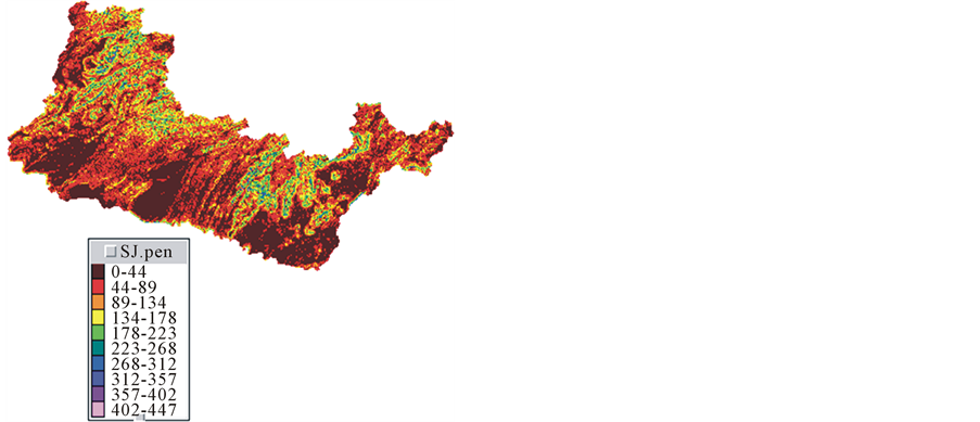
Figure 4. Slope classes.
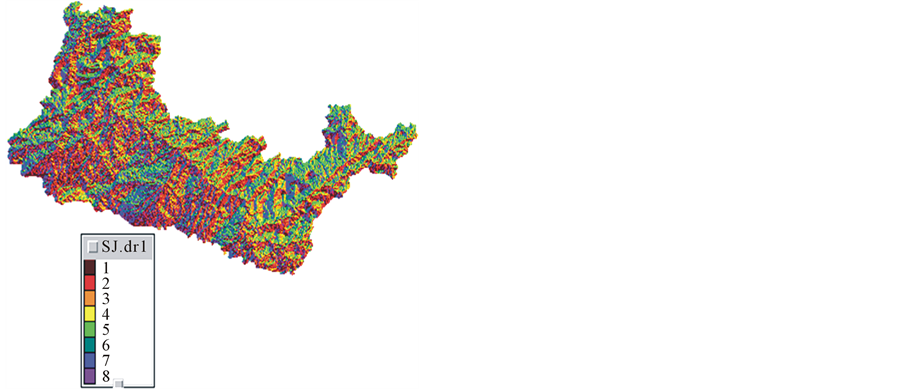
Figure 5. Drainage directions.
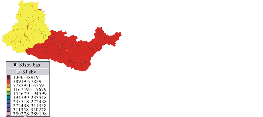
Figure 6. Hydrographic network & sub basins.

Table 1. Weight stations by Theissen method.
Table 2. Production class.
3. Results and Discussion
In this study, the functions used by ATHYS model are SCS and unit hydrograph for the production and transfer function. The sensitivity analysis of model has allowed to show the best values of the parameter S (SCS) affecting mainly the peak flow. The decline of the hydrograph explained by the emptying time is generally influenced by the (Ds) parameter. Preferentially, we fix the influenced parameters on the general curve of the hydrograph, namely, the diffusion coefficient (K0), the parameters K1 and Alfa, and the transfer speed of V0, which figures on the transfer function (Table 3).
The statistic evaluators showed a good correlation between the monthly observed and simulated river discharge with R2 of 0.92, NSE of 0.83, and RSR of 0.41 for the calibration period. The validation period revealed good values for R2 0.90, NSE 0.81 and RSR 0.39, this model performance for both calibration and validation periods is evaluated as “very good performance rating” which is defined by the flowing ranges: 0 to 0.5 for RSR, 0.75 to 1 for NSE (Figure 7 and Figure 8).
4. Conclusion
The approach we adopted was to model the dynamics of Sidi Jabeur watershed functioning with the reconstitution of river flow at outlet (Station Sidi Jabeur) using the spatially distributed model (ATHYS). The model was successfully calibrated in the Sidi Jabeur watershed and produced good simulation results. The evaluation of the
Table 3. Parameters of production and transfer functions.
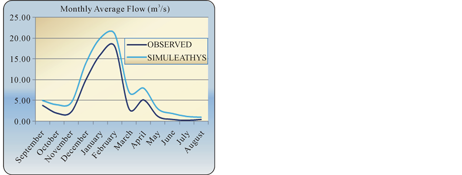
Figure 7. Simulation of mean monthly flows Simulated in Ouljet Haboub station over (1996-2004).
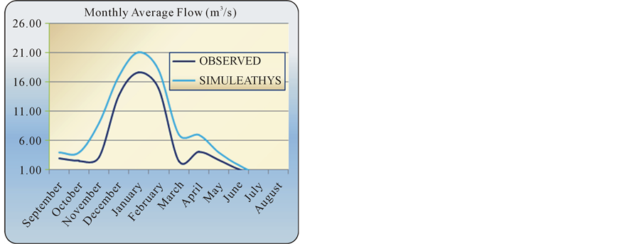
Figure 8. Simulation of mean monthly flows simulated in Sidi Jabeur station over (1996-2004).
model performance was carried out successfully with the recommended statistical coefficients, the comparison of observed and simulated flow stream revealed a Nash-Sutcliffe coefficient and R² superior to 0.81 for both calibration and validation periods. This study showed the ability of ATHYS model to be used to simulate the water quantity in semi-arid regions.
Acknowledgements
The authors thank the Ministry of Energy, Mines, Water and Environment (S.Water-Dr.Brirhet) for providing the data on the studied boreholes.
Cite this paper
MouradKhattati,MostaphaSerroukh,IsmailRafik,HakimMesmoudi,BrirhetHassane,YassineBouslihim, (2016) Hydrological Modelling of Sidi Jabeur Watershed (Morocco) Using Spatially Distributed Model ATHYS. Journal of Geoscience and Environment Protection,04,77-83. doi: 10.4236/gep.2016.41009
References
- 1. Fadil, A., Rhinane, H., Kaoukaya, A., Kharchaf, Y. and Bachir, O. (2011) Hydrologic Modeling of the Bouregreg Watershed (Morocco) Using GIS and SWAT Model. Journal of Geographic Information System, 3, 279.
http://dx.doi.org/10.4236/jgis.2011.34024 - 2. Sivapalan, M. (2003) Process Complexity at Hillslope Scale, Process Simplicity at the Watershed Scale: Is There a Connection? Hydrological Processes, 17, 1037-1041.
http://dx.doi.org/10.1002/hyp.5109 - 3. Nash, J.E. and Sutcliffe, J.V. (1970) River Flow Forecasting through Conceptual Models, Discussion of Principles. Journal of Hydrology, 10, 282-290.
http://dx.doi.org/10.1016/0022-1694(70)90255-6 - 4. Singh, J., Knapp, H.V. and Demissie, M. (2004) Hydrologic Modeling of the Iroquois River Watershed Using HSPF and SWAT. Journal of the American Water Resources Association, 41, 343-360.
http://dx.doi.org/10.1111/j.1752-1688.2005.tb03740.x
NOTES

*Corresponding author.