Paper Menu >>
Journal Menu >>
 International Journal of Geosciences, 2011, 2, 610-630 doi:10.4236/ijg.2011.24063 Published Online November 2011 (http://www.SciRP.org/journal/ijg) Copyright © 2011 SciRes. IJG A Unified Model of Neoar c hean-Pro terozoic Convergence and Rifting of Indian Cratons: Geophysical Constraints Dinesh Chandra Mishra National Geophysical Research Institute (CSIR), Hyderabad, India E-mail: dcm_ngri@yahoo.co.in Received May 6, 2011; revised August 2, 2011; accepted September 18, 2011 Abstract Neoarchean and Proterozoic sutures and collision zones are identified in the Indian Peninsular Shield based on high seismic velocity; gravity highs and high conductivity in the upper crust due to thrusting while sub- ducted side are demarcated based on geophysical signatures of crustal thickening and back arc type basins. Some of them appear to form triple junctions. The Bouguer anomaly map of the south Indian shield when transformed to apparent density map through harmonic inversion, provided high density linear zones coin- ciding with the shear zone and the transition zone-the Moyar Bhavani Shear Zone (MBSZ) between the Eastern Dharwar Craton (EDC) and the Western Dharwar Craton (WDC) and the Dharwar cratons and the Southern Granulite Terrain (SGT), respectively. It is supported by high seismic velocity and high conductiv- ity suggesting them to be caused by high grade granulite rocks related to Neoarchean-Paleoproterozoic su- tures and collision zones. These investigations also suggest thick crust (~40 - 50 km) under the WDC and the SGT forming crustal root of 50 - 52 km in the south western part and thin crust of 31 - 32 km under the EDC indicating direction of convergence and subduction as E-W and N-S between the EDC and the WDC and Dharwar cratons and the SGT, respectively. It gave rise to contemporary lower crustal granulite rocks in the northern part of the SGT and Cauvery shear zone (CSZ) as collision related central core complex of various deep seated intrusive rocks of Paleo-Mesoproterozoic period. The second case belonging to Meso-protero- zoic period is related to the collision of the Bundelkhand craton and the Bhandara-Bastar craton (BBC) and the Dharwar craton (DC) in Central India along the Satpura Mobile Belt (SMB) and the BBC and the DC along the Godavari Proterozoic Belt due to N-S and NE-SW convergences, respectively. This process has given rise to lower crustal granulite rocks of high density, high velocity and high conductivity along the SMB and the GPB. An upper mantle conductor delineated south of the western part of the SMB under Dec- can Volcanic Province and a regional gravity gradient almost sub parallel to it indicate an interface with flu- ids separating rocks of different densities that appears to demarcate the trace of the Proterozoic subduction and suture related to the SMB collision zone during Mesoproterozoic period. High reflectivity of the lower crust along seismic profiles across the SMB indicate an extensional phase prior to this convergence. The SMB is connected to the Aravalli Delhi Mobile Belt (ADMB) in the western part that is another collision zone of Meso-proterozoic period, forming an arcuate shaped collision zone between the Bundelkhand craton and Rajasthan block with E-W convergence. There are indications of a prior phase of convergence during Paleo-Proterozoic period followed by rifting during Paleo-Meso-proterozoic period (~1.9 - 1.6 Ga) along the SMB, the ADMB and the GPB that gave rise to large scale contemporary intrusive in these sections. The contemporary Mahakoshal-Bijawar and Pakhal group of rocks of Paleo Proterozoic period (~1.9 - 1.6 Ga) were deposited over the rifted platform of the Bundelkhand craton along the SMB and cratons along the GPB, respectively during the extensional phase as suggested above based on high reflectivity of the lower crust. It is followed by deposition of the Vindhyan sediments of Meso-Neoproterozoic period (~1.6 - 0.7 Ga) along the SMB and the ADMB as foreland basins during Meso-Neoproterozoic convergence. Simultaneous N-S and E-W directed convergences in the two cases, viz., the SMB and the ADMB that are connected forming an arcuate shaped collision zone suggest NE-SW directed primary stress direction similar to the GPB that is supported by NW-SE oriented large lineaments in Bundelkhand craton and Peninsular shield. The Eastern Ghat Mobile Belt (EGMB) also shows signatures of E-W or NE-SW directed Mesoproterozoic (~1.5 - 1.0 Ga) 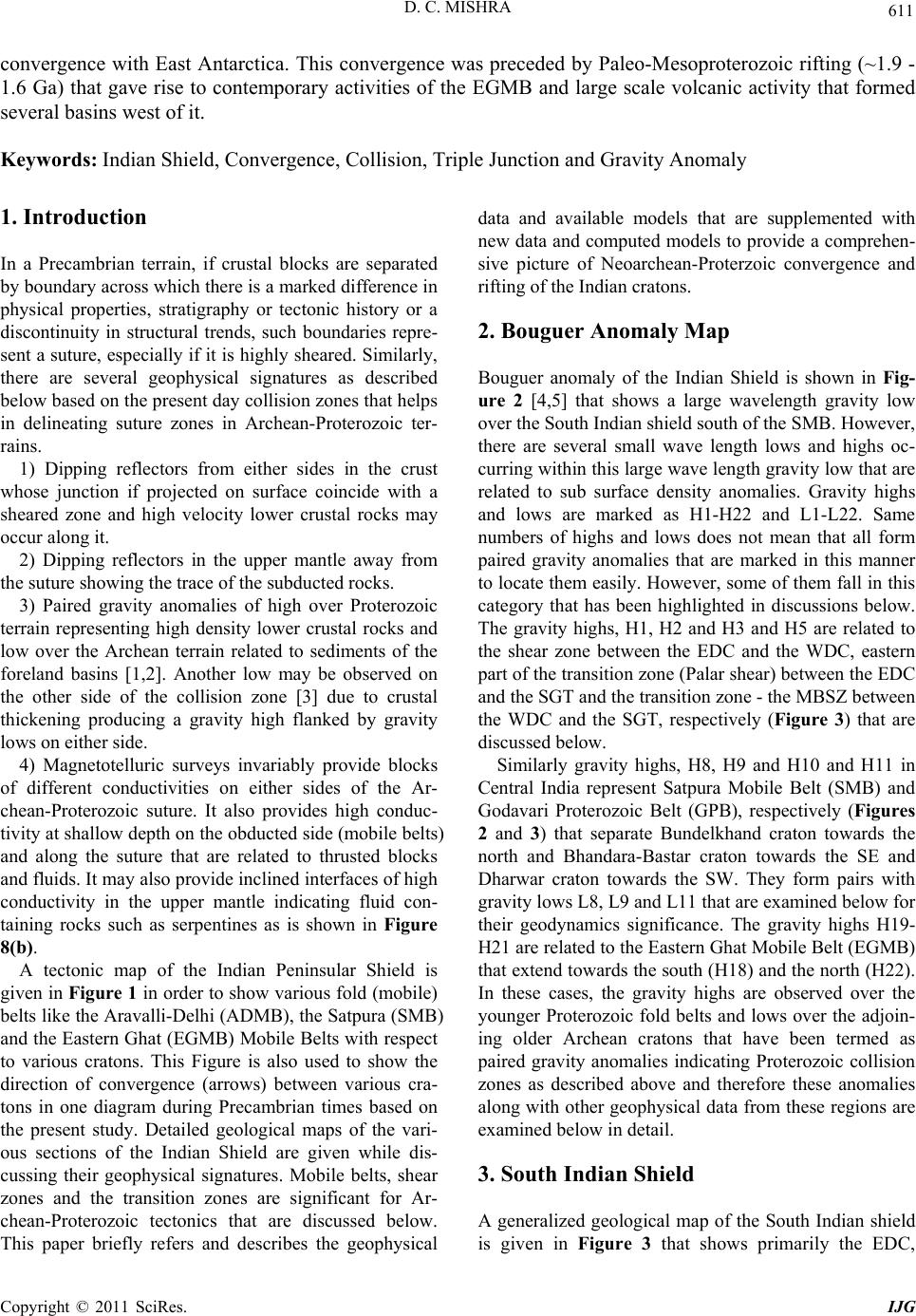 D. C. MISHRA Copyright © 2011 SciRes. IJG 611 convergence with East Antarctica. This convergence was preceded by Paleo-Mesoproterozoic rifting (~1.9 - 1.6 Ga) that gave rise to contemporary activities of the EGMB and large scale volcanic activity that formed several basins west of it. Keywords: Indian Shield, Convergence, Collision, Triple Junction and Gravity Anomaly 1. Introduction In a Precambrian terrain, if crustal blocks are separated by boundary acro ss which there is a marked difference in physical properties, stratigraphy or tectonic history or a discontinuity in structural trends, such boundaries repre- sent a suture, especially if it is highly sheared. Similarly, there are several geophysical signatures as described below based on the present day collisio n zones that he lps in delineating suture zones in Archean-Proterozoic ter- rains. 1) Dipping reflectors from either sides in the crust whose junction if projected on surface coincide with a sheared zone and high velocity lower crustal rocks may occur along it. 2) Dipping reflectors in the upper mantle away from the suture showing the trace of the subducted rocks. 3) Paired gravity anomalies of high over Proterozoic terrain representing high density lower crustal rocks and low over the Archean terrain related to sediments of the foreland basins [1,2]. Another low may be observed on the other side of the collision zone [3] due to crustal thickening producing a gravity high flanked by gravity lows on either side. 4) Magnetotelluric surveys invariably provide blocks of different conductivities on either sides of the Ar- chean-Proterozoic suture. It also provides high conduc- tivity at shallow depth on th e obducted side (mobile belts) and along the suture that are related to thrusted blocks and fluids. It may also provide inclined interfaces of high conductivity in the upper mantle indicating fluid con- taining rocks such as serpentines as is shown in Figure 8(b). A tectonic map of the Indian Peninsular Shield is given in Figure 1 in order to show various fold (mobile) belts like the Aravalli-Delhi (ADMB), the Satpura (SMB) and the Eastern Ghat (EGMB) Mobile Belts with respect to various cratons. This Figure is also used to show the direction of convergence (arrows) between various cra- tons in one diagram during Precambrian times based on the present study. Detailed geological maps of the vari- ous sections of the Indian Shield are given while dis- cussing their geophysical signatures. Mobile belts, shear zones and the transition zones are significant for Ar- chean-Proterozoic tectonics that are discussed below. This paper briefly refers and describes the geophysical data and available models that are supplemented with new data and computed models to provide a comprehen- sive picture of Neoarchean-Proterzoic convergence and rifting of the Indian cratons. 2. Bouguer Anomaly Map Bouguer anomaly of the Indian Shield is shown in Fig- ure 2 [4,5] that shows a large wavelength gravity low over the South Indian shield south of the SMB. However, there are several small wave length lows and highs oc- curring within this large wave length gravity low that are related to sub surface density anomalies. Gravity highs and lows are marked as H1-H22 and L1-L22. Same numbers of highs and lows does not mean that all form paired gravity anomalies that are marked in this manner to locate them easily. However, some of them fall in this category that has been highlighted in discussions below. The gravity highs, H1, H2 and H3 and H5 are related to the shear zone between the EDC and the WDC, eastern part of the transition zone (Palar shear) between the EDC and the SGT and th e tran sitio n zon e - the MBSZ between the WDC and the SGT, respectively (Figure 3) that are discussed below. Similarly gravity highs, H8, H9 and H10 and H11 in Central India represent Satpura Mobile Belt (SMB) and Godavari Proterozoic Belt (GPB), respectively (Figures 2 and 3) that separate Bundelkhand craton towards the north and Bhandara-Bastar craton towards the SE and Dharwar craton towards the SW. They form pairs with gravity lows L8, L9 and L11 that are examined below for their geodynamics significance. The gravity highs H19- H21 are related to the Eastern Ghat Mob ile Belt (EGMB) that extend towards the south (H18) and the north (H22). In these cases, the gravity highs are observed over the younger Proterozoic fold belts and lows over the adjoin- ing older Archean cratons that have been termed as paired gravity anomalies indicating Proterozoic collision zones as described above and therefore these anomalies along with other geophysical data from these regions are examined below in detail. 3. South Indian Shield A generalized geological map of the South Indian shield is given in Figure 3 that shows primarily the EDC, 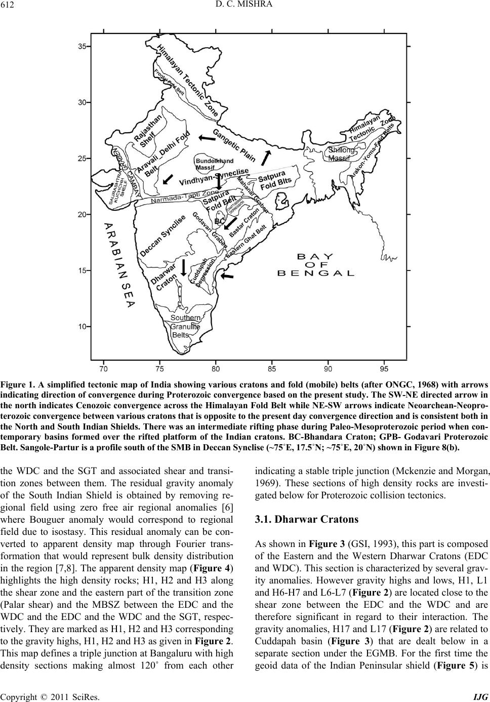 D. C. MISHRA Copyright © 2011 SciRes. IJG 612 Figure 1. A simplified tectonic map of India showing various cratons and fold (mobile) belts (after ONGC, 1968) with arrows indicating direction of convergence during Proterozoic convergence based on the present study. The SW-NE directed arrow in the north indicates Cenozoic convergence across the Himalayan Fold Belt while NE-SW arrows indicate Neoarchean-Neopro- terozoic convergence b etween various cratons that is opp o site to the p res ent day con v ergence direction and is con s istent both in the North and South Indian Shields. There was an intermediate rifting phase during Paleo-Mesoproterozoic period when con- temporary basins formed over the rifted platform of the Indian cratons. BC-Bhandara Craton; GPB- Godavari Proterozoic Belt. Sangole-Partur is a profile so u t h of the SMB in Deccan Synclise (~75˚E, 17.5˚N; ~75˚E, 20˚N) shown in Figure 8(b). the WDC and the SGT and associated shear and transi- tion zones between them. The residual gravity anomaly of the South Indian Shield is obtained by removing re- gional field using zero free air regional anomalies [6] where Bouguer anomaly would correspond to regional field due to isostasy. This residual anomaly can be con- verted to apparent density map through Fourier trans- formation that would represent bulk density distribution in the region [7,8]. The apparent density map (Figure 4) highlights the high density rocks; H1, H2 and H3 along the shear zone and the eastern part of the transition zone (Palar shear) and the MBSZ between the EDC and the WDC and the EDC and the WDC and the SGT, respec- tively. They are marked as H1, H2 and H3 corresp ond ing to the gravity hig hs, H1, H2 and H3 as given in Figure 2. This map defines a triple junction at Bangaluru with high density sections making almost 120˚ from each other indicating a stable triple jun ction (Mckenzie and Morgan, 1969). These sections of high density rocks are investi- gated below for Proterozoic collision tectonics. 3.1. Dharwar Cratons As shown in Figure 3 (GSI, 1993), this part is composed of the Eastern and the Western Dharwar Cratons (EDC and WDC). This section is characterized by several grav- ity anomalies. However gravity highs and lows, H1, L1 and H6-H7 and L6-L7 ( Figure 2) are loc ated c lose to the shear zone between the EDC and the WDC and are therefore significant in regard to their interaction. The gravity anomalies, H17 and L17 (Figure 2) are related to Cuddapah basin (Figure 3) that are dealt below in a separate section under the EGMB. For the first time the geoid data of the Indian Peninsular shield (Figure 5) is 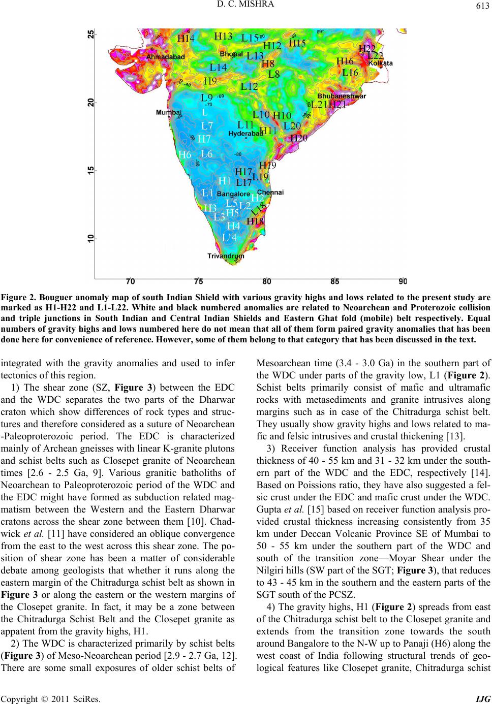 D. C. MISHRA Copyright © 2011 SciRes. IJG 613 Figure 2. Bouguer anomaly map of south Indian Shield with various gravity highs and lows related to the present study are marked as H1-H22 and L1-L22. White and black numbered anomalies are related to Neoarchean and Proterozoic collision and triple junctions in South Indian and Central Indian Shields and Eastern Ghat fold (mobile) belt respectively. Equal numbers of gravity highs and lows numbered here do not mean that all of them form paired gravity anomalies that has been done here for convenience of reference. However, some of them belong to that category that has been discussed in the text. integrated with the gravity anomalies and used to infer tectonics of this region. 1) The shear zone (SZ, Figure 3) between the EDC and the WDC separates the two parts of the Dharwar craton which show differences of rock types and struc- tures and therefore considered as a suture of Neoarchean -Paleoproterozoic period. The EDC is characterized mainly of Archean gneisses with lin ear K-granite pluton s and schist belts such as Closepet granite of Neoarchean times [2.6 - 2.5 Ga, 9]. Various granitic batholiths of Neoarchean to Paleoproterozoic period of the WDC and the EDC might have formed as subduction related mag- matism between the Western and the Eastern Dharwar cratons across the shear zone between them [10]. Chad- wick et al. [11] have considered an oblique convergence from the east to the west across this shear zone. The po- sition of shear zone has been a matter of considerable debate among geologists that whether it runs along the eastern margin of the Chitradurga schist belt as shown in Figure 3 or along the eastern or the western margins of the Closepet granite. In fact, it may be a zone between the Chitradurga Schist Belt and the Closepet granite as appatent from the gravity highs, H1. 2) The WDC is characterized primarily by schist belts (Figure 3) of Meso-Neoarchean period [2.9 - 2.7 G a, 12]. There are some small exposures of older schist belts of Mesoarchean time (3.4 - 3.0 Ga) in the southern part of the WDC under parts of the gravity low, L1 (Figure 2). Schist belts primarily consist of mafic and ultramafic rocks with metasediments and granite intrusives along margins such as in case of the Chitradurga schist belt. They usually show gravity highs and lows related to ma- fic and felsic intrusives and crustal thickening [13]. 3) Receiver function analysis has provided crustal thickness of 40 - 55 km and 31 - 32 km under the south- ern part of the WDC and the EDC, respectively [14]. Based on Poissions ratio, they have also suggested a fel- sic crust under the EDC and mafic crust under the WDC. Gupta et al. [15] based on receiver function analysis pro- vided crustal thickness increasing consistently from 35 km under Deccan Volcanic Province SE of Mumbai to 50 - 55 km under the southern part of the WDC and south of the transition zone—Moyar Shear under the Nilgiri hills (SW part of the SGT; Figure 3), that reduces to 43 - 45 km in the southern and the eastern parts of the SGT south of the PCSZ. 4) The gravity highs, H1 (Figure 2) spreads from east of the Chitradurga sch ist belt to the Closepet granite and extends from the transition zone towards the south around Bangalore to th e N-W up to Pan aj i (H6) along th e west coast of India following structural trends of geo- logical features like Closepet granite, Chitradurga schist 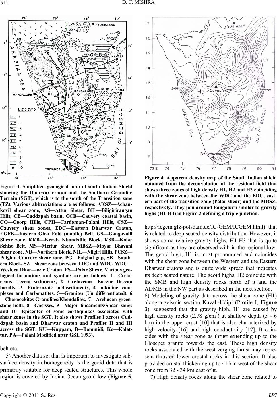 D. C. MISHRA Copyright © 2011 SciRes. IJG 614 Figure 3. Simplified geological map of south Indian Shield showing the Dharwar craton and the Southern Granulite Terrain (SGT), which is to the south of the Transition zone (TZ). Various abbreviations are as follows: AKSZ—Achan- kovil shear zone, AS—Attur Shear, BIL—Biligirirangan Hills, CB—Cuddapah basin, CCB—Cauvery coastal basin, CO—Coorg Hills, CPH—Cardoman-Palani Hills, CSZ— Cauvery shear zones, EDC—Eastern Dharwar Craton, EGFB—Eastern Ghat Fold (mobile) Belt, GS—Gangavalli Shear zone, KKB—Kerala Khondalite Block, KSB—Kolar Schist Belt, MS—Mettur Shear, MBSZ—Moyar Bhavani shear zone, NB—Northern Block, NIL—Nilgiri Hills, PCSZ— Palghat Cauvery shear zone, PG—Palghat gap, SB—South- ern Block, S Z—shear zone between EDC an d WDC, WDC— Western Dhar—war Craton, PS—Palar Shear . Various geo- logical formations and symbols are as follows: 1—Creta- ceous—recent sediments, 2—Cretaceous—Eocene Deccan basalts, 3—Proterozoic metasediments, 4—alkaline com- plexes and Carbonatites, 5—Granites (Un differentiated), 6 —Charnockite s-Granulites/K ho ndalites, 7—Archaean green- stone belts, 8—Gneisses, 9—Major lineaments/Shear zones and 10—Epicenter of some earthquakes associated with shear zones in the SGT. It also shows Profiles I across Cud- dapah basin and Dharwar craton and Profiles II and III across the SGT. KU—Kuppam, B—Bommidi, Ko—Kolat- tur, PA—Palani Modified after GSI, 1993). belt etc. 5) Another data set that is important to investigate sub- surface density in homogeneity is the geoid data that is primarily suitable for deep seated structures. This whole region is covered by Indian Ocean geoid low (Figure 5, Figure 4. Apparent density map of the South Indian shield obtained from the deconvolution of the residual field that shows three zones of high de nsity H1, H2 and H3 coinciding with the shear zone between the WDC and the EDC, east- ern part of the transition zone (Palar shear) and the MBSZ, respectively. They join ar ound Bangaluru similar to gravity highs (H1-H3) in Figure 2 defining a triple junction. http://icgem.gfz-potsdam.de/IC-GEM/ICGEM.html) that is related to deep seated density distribu tion. However, it shows some relative gravity highs, H1-H3 that is quite significant as they are observed with in the regional low. The geoid high, H1 is most pronounced and coincides with the shear zone between the Western and the Eastern Dharwar cratons and is quite wide spread that indicates its deep seated nature. The geoid highs, H2 coincide with the SMB and high density rocks north of it and the ADMB in the NW part as described in the next section. 6) Modeling of gravity data across the shear zone (H1) along a seismic section Kavali-Udipi (Profile I, Figure 3), suggested that the gravity high, H1 are caused by high density rocks (2.78 g/cm3) at shallow depth (5 - 6 km) in the upper crust [10] that is also characterized by high velocity [16] and high conductivity [17]. It coin- cides with the shear zone as thrust extending up to the Closepet granite towards the east. These high density rocks associated with the west verging thrust may repre- sent thrusted lower crustal rocks in this section. It also provided cr ustal th ick ening up to 41 km west of th e shear zone from 32 - 34 km east of it. 7) High density rocks along the shear zone related to 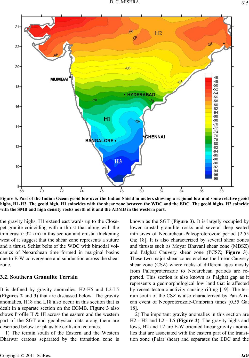 D. C. MISHRA Copyright © 2011 SciRes. IJG 615 Figure 5. Part of the Indian Ocean geoid low over the Indian Shield in meters showing a regional low and some relative geoid highs, H1-H3. The geoid high, H1 coincides with the shear zone between the WDC and the EDC. The geoid highs, H2 coincide with the SMB and high density roc ks nor t h of it and the ADMB in the we stern part. the gravity highs, H1 extend east wards up to the Close- pet granite coinciding with a thrust that along with the thin crust (~32 km) in this section and crustal thickening west of it suggest that the shear zone represents a suture and a thrust. Schist belts of the WDC with bimodal vol- canics of Neoarchean time formed in marginal basins due to E-W convergence and subduction across the shear zone. 3.2. Southern Granulite Terrain It is defined by gravity anomalies, H2-H5 and L2-L5 (Figures 2 and 3) that are discussed below. The gravity anomalies, H18 and L18 also occur in this section that is dealt in a separate section on the EGMB. Figure 3 also shows Profile II & III across the eastern and the western part of the SGT and geophysical data along them are described below for plausible collision tectonics. 1) The terrain south of the Eastern and the Western Dharwar cratons separated by the transition zone is known as the SGT (Figure 3). It is largely occupied by lower crustal granulite rocks and several deep seated intrusives of Neoarchean-Paleoproterozoic period [2.55 Ga; 18]. It is also characterized by several shear zones and thrusts such as Moyar Bhavani shear zone (MBSZ) and Palghat Cauvery shear zone (PCSZ; Figure 3). These two major shear zones enclose the linear Cauvery shear zone (CSZ) where rocks of different ages mostly from Paleoproterozoic to Neoarchean periods are re- ported. This section is also known as Palghat gap as it represents a geomorphological low land that is affected by recent tectonic activity causing rifting [19]. The ter- rain south of the CSZ is also characterized by Pan Afri- can event of Neoproterozoic-Cambrian times [0.55 Ga; 18]. 2) The important gravity anomalies in this section are H2 - H5 and L2 - L5 (Figure 2). The gravity highs and lows, H2 and L2 are E-W oriented linear gravity anoma- lies that are associated with the eastern part of the transi- tion zone (Palar shear) and separates the EDC and the 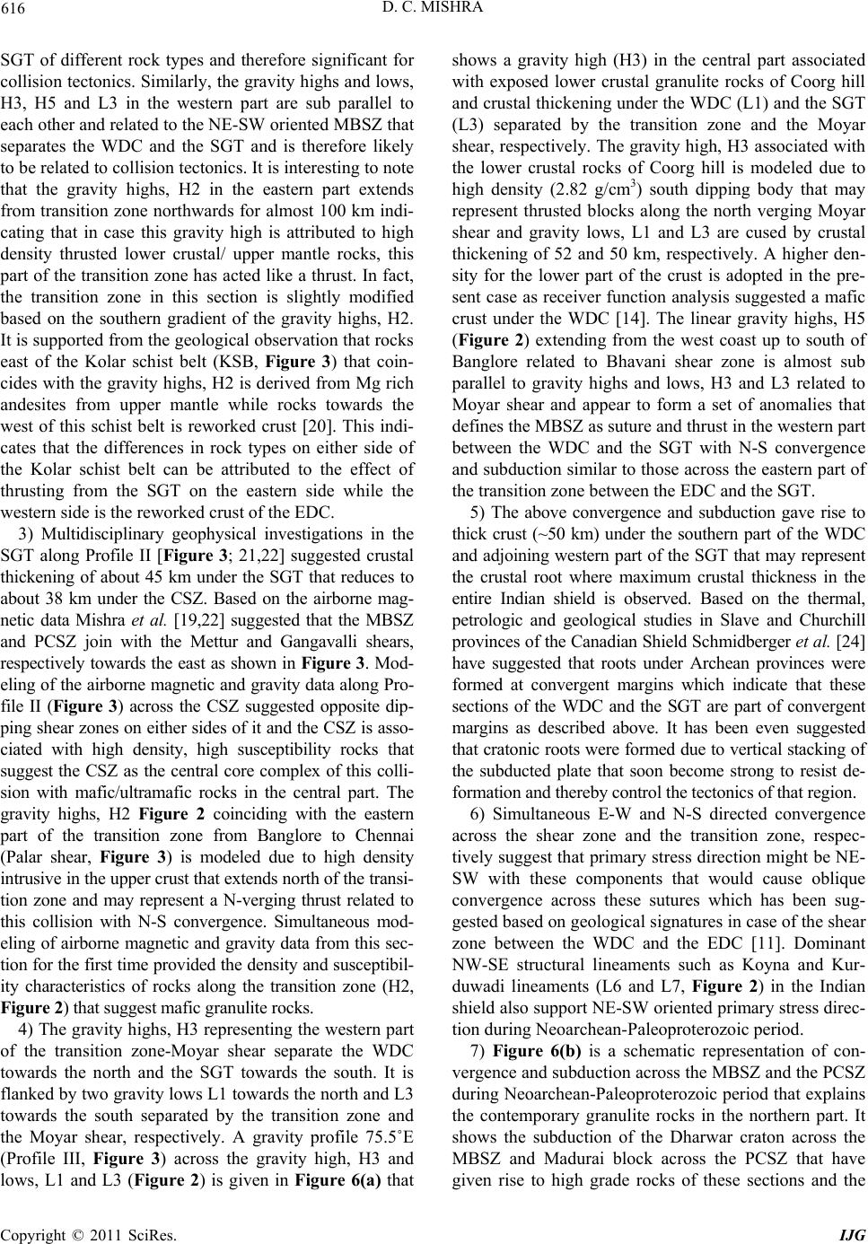 D. C. MISHRA Copyright © 2011 SciRes. IJG 616 SGT of different rock types and therefore significant for collision tectonics. Similarly, the grav ity highs and lows, H3, H5 and L3 in the western part are sub parallel to each other and related to the NE-SW oriented MBSZ that separates the WDC and the SGT and is therefore likely to be related to collision tectonics. It is interesting to note that the gravity highs, H2 in the eastern part extends from transition zone northwards for almost 100 km indi- cating that in case this gravity high is attributed to high density thrusted lower crustal/ upper mantle rocks, this part of the transition zone has acted like a thru st. In fact, the transition zone in this section is slightly modified based on the southern gradient of the gravity highs, H2. It is supported from the geological observ ation that rock s east of the Kolar schist belt (KSB, Figure 3) that coin- cides with the gravity highs, H2 is derived from Mg rich andesites from upper mantle while rocks towards the west of this schist belt is reworked crust [20]. This indi- cates that the differences in rock types on either side of the Kolar schist belt can be attributed to the effect of thrusting from the SGT on the eastern side while the western side is the reworked crust of the EDC. 3) Multidisciplinary geophysical investigations in the SGT along Profile II [Figure 3; 21,22] suggested crustal thickening of about 45 km under the SGT that reduces to about 38 km under the CSZ. Based on the airborne mag- netic data Mishra et al. [19,22] suggested that the MBSZ and PCSZ join with the Mettur and Gangavalli shears, respectively towards the eas t as shown in Figure 3. Mod- eling of the airborne magnetic and gravity data along Pro- file II (Figure 3) across the CSZ suggested opposite dip- ping shear zones on either sides of it and the CSZ is asso- ciated with high density, high susceptibility rocks that suggest the CSZ as the central core complex of this colli- sion with mafic/ultramafic rocks in the central part. The gravity highs, H2 Figure 2 coinciding with the eastern part of the transition zone from Banglore to Chennai (Palar shear, Figure 3) is modeled due to high density intrusive in the upper crust that extends north of the transi- tion zone and may represent a N-verging thrust related to this collision with N-S convergence. Simultaneous mod- eling of airborne magnetic and gravity data from this sec- tion for the first time provided the density and susceptibil- ity characteristics of rocks along the transition zone (H2, Figure 2) that suggest mafic granulite rocks. 4) The gravity highs, H3 representing the western part of the transition zone-Moyar shear separate the WDC towards the north and the SGT towards the south. It is flanked by two gr avity lows L1 towards th e north an d L3 towards the south separated by the transition zone and the Moyar shear, respectively. A gravity profile 75.5˚E (Profile III, Figure 3) across the gravity high, H3 and lows, L1 and L3 (Figure 2) is given in Figure 6(a) that shows a gravity high (H3) in the central part associated with exposed lower crustal granulite rocks of Coorg hill and crustal thickening under the WDC (L1) and the SGT (L3) separated by the transition zone and the Moyar shear, respectively. The gravity high, H3 associated with the lower crustal rocks of Coorg hill is modeled due to high density (2.82 g/cm3) south dipping body that may represent thrusted blocks along the north verging Moyar shear and gravity lows, L1 and L3 are cused by crustal thickening of 52 and 50 km, respectively. A higher den- sity for the lower part of the crust is adopted in the pre- sent case as receiver function analysis suggested a mafic crust under the WDC [14]. The linear gravity highs, H5 (Figure 2) extending from the west coast up to south of Banglore related to Bhavani shear zone is almost sub parallel to gravity highs and lows, H3 and L3 related to Moyar shear and appear to form a set of anomalies that defines the MBSZ as suture and thrust in the western part between the WDC and the SGT with N-S convergence and subduction similar to those across the eastern part of the transition zone be tween the EDC and the SGT. 5) The above convergence and subduction gave rise to thick crust (~50 km) under the southern part of the WDC and adjoining western part of the SGT that may represent the crustal root where maximum crustal thickness in the entire Indian shield is observed. Based on the thermal, petrologic and geological studies in Slave and Churchill provinces of the Canadian Shield Schmidberger et al. [24] have suggested that roots under Archean provinces were formed at convergent margins which indicate that these sections of the WDC and the SGT are part of convergent margins as described above. It has been even suggested that cratonic roots were formed due to vertical stacking of the subducted plate that soon become strong to resist de- formation and thereby cont rol the tectonics of that region. 6) Simultaneous E-W and N-S directed convergence across the shear zone and the transition zone, respec- tively suggest that primary stress direction might be NE- SW with these components that would cause oblique convergence across these sutures which has been sug- gested based on geological signatures in case of the shear zone between the WDC and the EDC [11]. Dominant NW-SE structural lineaments such as Koyna and Kur- duwadi lineaments (L6 and L7, Figure 2) in the Indian shield also suppor t NE-SW oriented pr imary stress direc- tion during Neoarchean-Paleoproteroz oi c p e ri o d. 7) Figure 6(b) is a schematic representation of con- vergence an d subdu ction across th e MBSZ and th e PCSZ during Neoarchean-Paleoproterozoic period that explains the contemporary granulite rocks in the northern part. It shows the subduction of the Dharwar craton across the MBSZ and Madurai block across the PCSZ that have given rise to high grade rocks of these sections and the 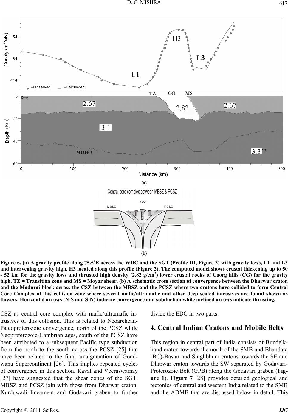 D. C. MISHRA Copyright © 2011 SciRes. IJG 617 (a) (b) Figure 6. (a) A gravity profile along 75.5˚E across the WDC and the SGT (Profile III, Figure 3) with gravity lows, L1 and L3 and intervening gravity high, H3 located along this profile (Figure 2). The computed model shows crustal thickening up to 50 - 52 km for the gravity lows and thrusted high density (2.82 g/cm3) lower crustal rocks of Coorg hills (CG) for the gravity high. TZ = Transition zone and MS = Moyar shear. (b) A schematic cross section of convergence between the Dharwar craton and the Madurai block across the CSZ between the MBSZ and the PCSZ where two cratons have collided to form Central Core Complex of this collision zone where several mafic/ultramafic and other deep seated intrusives are found shown as flowers. Horizontal arrows (N-S and S-N) indicate conver gence and subduc tion while inclined arrows indicate thr usting. CSZ as central core complex with mafic/ultramafic in- trusives of this collision. This is related to Neoarchean- Paleoproterozoic convergence, north of the PCSZ while Neoproterozoic-Cambrian ages, south of the PCSZ have been attributed to a subsequent Pacific type subduction from the north to the south across the PCSZ [25] that have been related to the final amalgamation of Gond- wana Supercontinent [26]. This implies repeated cycles of convergence in this section. Raval and Veeraswamay [27] have suggested that the shear zones of the SGT, MBSZ and PCSZ join with those from Dharwar craton, Kurduwadi lineament and Godavari graben to further divide the EDC in two parts. 4. Central Indian Cratons and Mobile Belts This region in central part of India consists of Bundelk- hand craton towards the north of the SMB and Bhandara (BC)-Bastar and Singhbhum cratons towards the SE and Dharwar craton towards the SW separated by Godavari- Proterozoic Belt (GPB) along the Godavari graben (Fig- ure 1). Figure 7 [28] provides detailed geological and tectonics of central and western India related to the SMB and the ADMB that are discussed below in detail. This 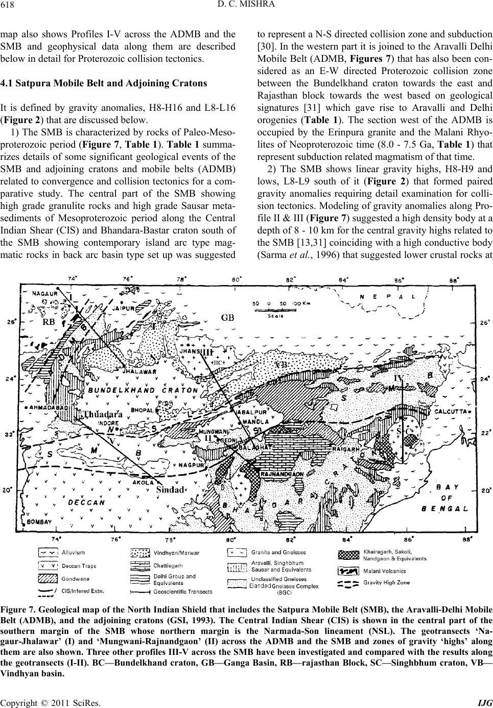 D. C. MISHRA Copyright © 2011 SciRes. IJG 618 map also shows Profiles I-V across the ADMB and the SMB and geophysical data along them are described below in detail for Proterozoic collision tectonics. 4.1 Satpura M obi l e Bel t and Adjoinin g Cratons It is defined by gravity anomalies, H8-H16 and L8-L16 (Figure 2) that are discussed below. 1) The SMB is characterized by rocks of Paleo-Meso- proterozoic period (Figure 7, Table 1). Table 1 summa- rizes details of some significant geological events of the SMB and adjoining cratons and mobile belts (ADMB) related to convergence and collision tectonics for a com- parative study. The central part of the SMB showing high grade granulite rocks and high grade Sausar meta- sediments of Mesoproterozoic period along the Central Indian Shear (CIS) and Bhandara-Bastar craton south of the SMB showing contemporary island arc type mag- matic rocks in back arc basin type set up was suggested to represent a N-S directed collision zo ne and subdu ction [30]. In the western part it is joined to the Aravalli Delhi Mobile Belt (ADMB, Figures 7) that has also been con- sidered as an E-W directed Proterozoic collision zone between the Bundelkhand craton towards the east and Rajasthan block towards the west based on geological signatures [31] which gave rise to Aravalli and Delhi orogenies (Table 1). The section west of the ADMB is occupied by the Erinpura granite and the Malani Rhyo- lites of Neoproterozoic time (8.0 - 7.5 Ga, Table 1) that represent subduction related magmatism of that time. 2) The SMB shows linear gravity highs, H8-H9 and lows, L8-L9 south of it (Figure 2) that formed paired gravity anomalies requiring detail examination for colli- sion tectonics. Modeling of gravity anomalies along Pro- file II & III (Figure 7) suggested a high density body at a depth of 8 - 10 km for the central gr avity highs related to the SMB [13,31] coin ciding with a high con ductive bod y (Sarma et al., 1996) that sugg ested lower crustal rocks at Figure 7. Geological map of the North Indian Shield that includes the Satpura Mobile Belt (SMB), the Aravalli-Delhi Mobile Belt (ADMB), and the adjoining cratons (GSI, 1993). The Central Indian Shear (CIS) is shown in the central part of the southern margin of the SMB whose northern margin is the Narmada-Son lineament (NSL). The geotransects ‘Na- gaur-Jhalawar’ (I) and ‘Mungwani-Rajnandgaon’ (II) across the ADMB and the SMB and zones of gravity ‘highs’ along them are also shown. Three other profiles III-V across the SMB have been investigated and compar ed with the results along the geotransects (I-II). BC—Bundelkhand craton, GB—Ganga Basin, RB—rajasthan Block, SC—Singhbhum craton, VB— Vindhyan basin. 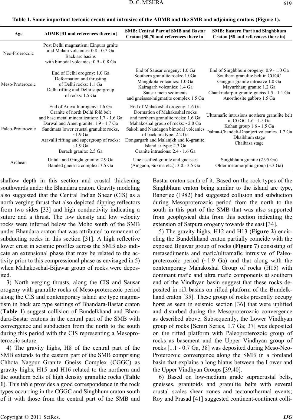 D. C. MISHRA Copyright © 2011 SciRes. IJG 619 Table 1. Some important tectonic events and intrusive of the ADMB and the SMB and adjoining cratons (Figure 1). Age ADMB [31 and references there in] SMB: Central Part of SMB and Bastar Craton [30,70 and references there in]SMB: Eastern Part and Singhbhum Craton [58 and references there in] Neo-Proerozoic Post Delhi magmatism: Einpura g rnite and Malani volcanics: 0 .8 - 0.7 Ga Back arc basins with bimodal volcanics: 0.9 - 0.8 Ga Meso-Proterozoic End of Delhi orogeny: 1.0 Ga Deformation and th rusting of Delhi rocks: 1.1 Ga Delhi rifting and Delhi supergroup of rocks: 1.5 Ga End of Sausar orogeny: 1.0 Ga Southern granulite rocks: 1.0Ga Mangikota volcanics: 1.0 Ga Kairagarh volcanics: 1.4 Ga Sausar meta sediments and gneisses/migmatite complex 1.5 Ga End of Singhbhum orogeny: 0.9 - 1.0 Ga Southern granulite belt in CGGC Gangpur granite intrusive 1.0 Ga Mayurbhanj granite 1.2 Ga Chankradarpur granite-gneiss 1.5 - 1.1 Ga Anorthosite gabbro 1.5 Ga Paleo-Proterozoic End of Aravalli orogeny: 1.6 Ga Granite of north Delhi fold belt and base metal mineralization: 1.7 - 1.6 Ga Darwal and Amet granite: 1 .9 - 1.7 Ga Sandmata lower crustal granulite rocks, ~1.9 Ga Aravalli rifting and supergroup of rocks: ~1.9 Ga Berach granite: 2.5 Ga End of Mahakosha l orogeny: 1.6 Ga Dormation of Mahakoshal rocks and northern granulite rocks: 1.6 Ga Mahakoshal group of rocks: ~2.0 Ga Sakoli and Nandagon bimodal volcanics of back arc type: 2.2 Ga Dongargarh and Malanjkh and K-grani te, Island ar type : 2.3 Ga Granite intrusions: 2.4 - 1.6 Ga Ultramafic intrusions northern granulite belt in CGGC 1.6 - 1.5 Ga Kohan group 1.6 - 1.5 Ga Dalma-Chandeli-Dhanjori volcanics. 1.7 Ga Dhaibhum stage Chaibasa stage Archean Untala and Gingla granite: 2.9 Ga Banded gneissic complex: 3.5 Ga Unclassified granite and gneisses (Amgaon, Sukma etc.): 3.0 - 3.5 Ga Singhbhum gr an it e (2.95 Ga) Older metamorphic group (3.3 Ga) shallow depth in this section and crustal thickening southwards under the Bhandara craton. Gravity modeling also suggested that the Central Indian Shear (CIS) as a north verging thrust that also depicted dipping reflectors from two sides [33] and high conductivity indicating a suture and a thrust. The low density and low velocity rocks were inferred below the Moho south of the SMB under Bhandara craton that was attributed to remanent of subducting rocks in this section [31]. A high reflective lower crust in seismic profiles acro ss the SMB also indi- cate an extensional phase that may be related to the ac- tivity prior to this compressional phase as envisaged in 5) when Mahakoschal-Bijawar group of rocks were depos- ited. 3) North verging thrusts, along the CIS and Sausar orogeny with granu lite rocks of Meso-protero zoic period along the CIS and contemporary island arc type magma- tism in back arc type settings of Bhandara-Bastar craton (Table 1) suggest collision of Bundelkhand and Bhan- dara-Bastar cratons in the central part of the SMB with convergence and subduction from the north to the south during this period with the CIS representing a Mesopro- terozoic suture. 4) The gravity highs, H8 of the central part of the SMB extends to the eastern part of the SMB comprising Chhota Nagpur Granite Gneiss Complex (CGGC) as gravity highs, H15 and H16 related to the northern and the southern belts of high density granulite rocks (Table 1). This table provid es a goo d correspondence in the rock types occurring in the CGGC and Singbhum craton south of it with those from the central part of the SMB and Bastar craton south of it. Based on the rock types of the Singhbhum craton being similar to the island arc type, Banerjee (1982) had suggested collision and subduction during Mesoproterozoic period from the north to the south in this part of the SMB that was also supported from geophysical data from this section indicating the extension of Satpura orogeny towards the east [34]. 5) The gravity highs, H12 and H13 (Figure 2) encir- cling the Bundelkhand craton partially coincide with the exposed Bija war group of rocks ( Figure 7) consisting of metasediments and mafic/ultramafic intrusive of Paleo- proterozoic period (~1.9 Ga) and that along with the contemporary Mahakoshal Group of rocks (H15) with dominant mafic and ultra mafic components at southern end of the Vindhyan basin suggest that these rocks de- posited in rift basins on rifted platform of the Bundelk- hand craton [35]. These group of rocks presently occupy horst as seen in seismic section [36] that were uplifted and disturbed during the Mesoproterozoic convergence as described above. Subsequently, the Lower Vindhyan group of rocks [Semri Series, 1.7 Ga; 37] was deposited on the rifted platform with Paleoproterozoic group of rocks as basement and the Upper Vindhyan group of rocks [1.1 - 0.7 Ga, 38] was deposited during Meso-Neo- Proterozoic convergence along the SMB in a foreland basin that explains a long hiatus between the Lower and the Upper Vindhyan Groups [39,40]. 6) Based on low-medium grade supracrustal belts, gneisses, granitoids and granulite belts with several crustal scales shear zones and tectonothermal events; Roy and Prasad [41] sug gested continent-contin ent colli- 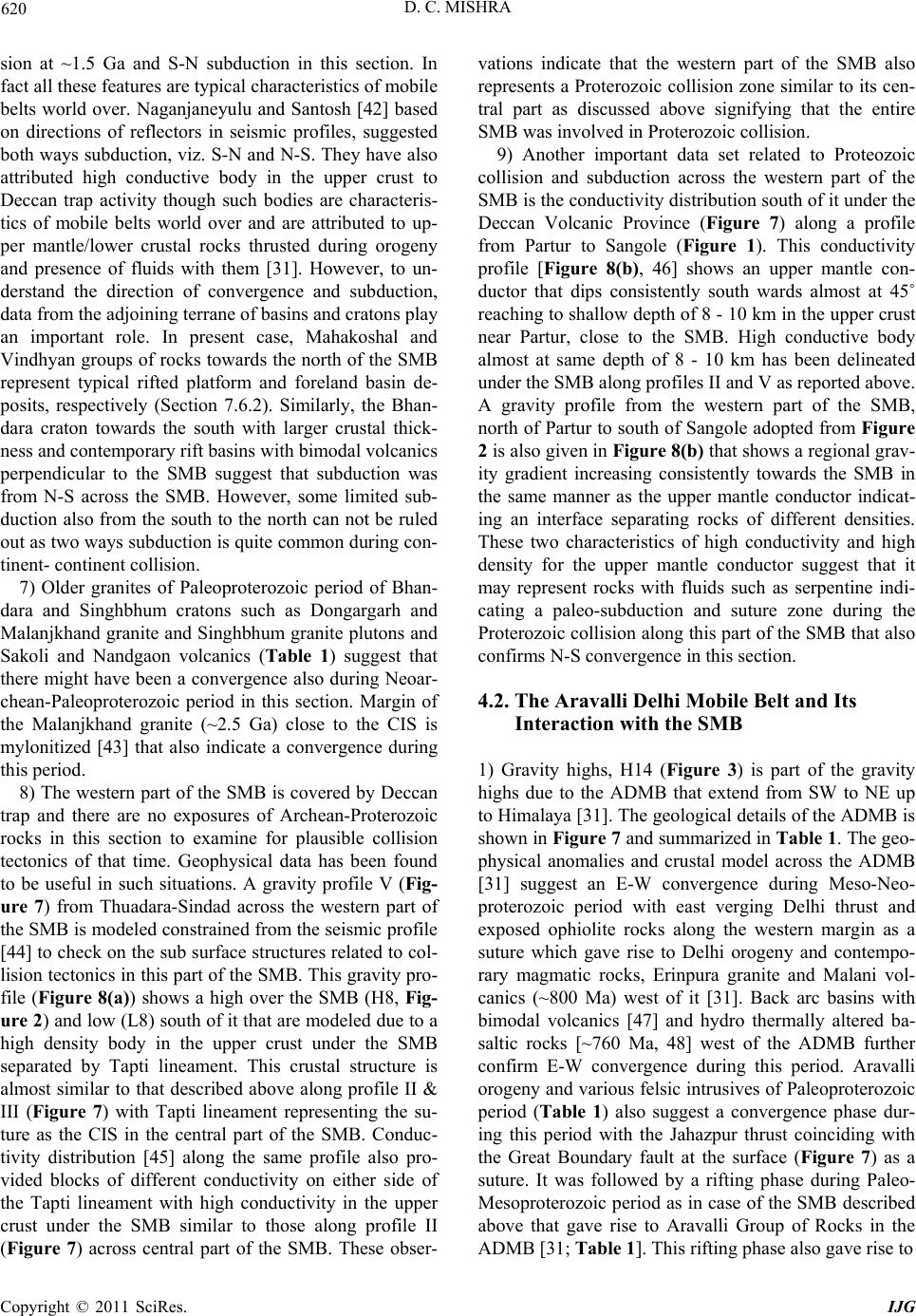 D. C. MISHRA Copyright © 2011 SciRes. IJG 620 sion at ~1.5 Ga and S-N subduction in this section. In fact all these features are typical characteristics of mobile belts world over. Naganjaneyulu and Santosh [42] based on directions of reflectors in seismic profiles, suggested both ways subduction, viz. S-N and N-S. They have also attributed high conductive body in the upper crust to Deccan trap activity though such bodies are characteris- tics of mobile belts world over and are attributed to up- per mantle/lower crustal rocks thrusted during orogeny and presence of fluids with them [31]. However, to un- derstand the direction of convergence and subduction, data from the adjoining terrane of basins and cratons play an important role. In present case, Mahakoshal and Vindhyan gr oups of rocks towards the north of the SMB represent typical rifted platform and foreland basin de- posits, respectively (Section 7.6.2). Similarly, the Bhan- dara craton towards the south with larger crustal thick- ness and contemporary rift basins with bimodal volcanics perpendicular to the SMB suggest that subduction was from N-S across the SMB. However, some limited sub- duction also from the south to the north can not be ruled out as two ways subduction is quite common during con- tinent- continen t collision. 7) Older granites of Paleoproterozoic period of Bhan- dara and Singhbhum cratons such as Dongargarh and Malanjkhand granite and Singhbhum granite plutons and Sakoli and Nandgaon volcanics (Table 1) suggest that there might have been a convergence also during Neoar- chean-Paleoproterozoic period in this section. Margin of the Malanjkhand granite (~2.5 Ga) close to the CIS is mylonitized [43] that also indicate a convergence during this period. 8) The western part of the SMB is covered by Deccan trap and there are no exposures of Archean-Proterozoic rocks in this section to examine for plausible collision tectonics of that time. Geophysical data has been found to be useful in such situations. A gravity profile V (Fig- ure 7) from Thuadara-Sindad across the western part of the SMB is modeled constrained fro m the seismic profile [44] to check on the sub surface structures related to col- lision tectonics in this part of the SMB. This gravity pro- file (Figure 8(a)) shows a high over the SMB (H8, Fig- ure 2) and low (L8) south of it that are modeled due to a high density body in the upper crust under the SMB separated by Tapti lineament. This crustal structure is almost similar to that described above along profile II & III (Figure 7) with Tapti lineament representing the su- ture as the CIS in the central part of the SMB. Conduc- tivity distribution [45] along the same profile also pro- vided blocks of different conductivity on either side of the Tapti lineament with high conductivity in the upper crust under the SMB similar to those along profile II (Figure 7) across central part of the SMB. These obser- vations indicate that the western part of the SMB also represents a Proterozoic collision zon e similar to its cen- tral part as discussed above signifying that the entire SMB was involved in Proterozoic collision. 9) Another important data set related to Proteozoic collision and subduction across the western part of the SMB is the conductivity distribution south of it under the Deccan Volcanic Province (Figure 7) along a profile from Partur to Sangole (Figure 1). This conductivity profile [Figure 8(b), 46] shows an upper mantle con- ductor that dips consistently south wards almost at 45˚ reaching to shallow depth of 8 - 10 km in the upper crust near Partur, close to the SMB. High conductive body almost at same depth of 8 - 10 km has been delineated under the SMB along profiles II and V as reported above. A gravity profile from the western part of the SMB, north of Partur to south of Sangole adopted from Figure 2 is also given in Figure 8(b) that shows a regional grav - ity gradient increasing consistently towards the SMB in the same manner as the upper mantle conductor indicat- ing an interface separating rocks of different densities. These two characteristics of high conductivity and high density for the upper mantle conductor suggest that it may represent rocks with fluids such as serpentine indi- cating a paleo-subduction and suture zone during the Proterozoic collision alon g this part of the SMB that also confirms N- S convergence in this section. 4.2. The Aravalli Delhi Mobile Belt and Its Interaction with the SMB 1) Gravity highs, H14 (Figure 3) is part of the gravity highs due to the ADMB that extend from SW to NE up to Himalaya [31]. The geological details of the ADMB is shown in Figure 7 and summarized in Ta ble 1. Th e geo- physical anomalies and crustal model across the ADMB [31] suggest an E-W convergence during Meso-Neo- proterozoic period with east verging Delhi thrust and exposed ophiolite rocks along the western margin as a suture which gave rise to Delhi orogeny and contempo- rary magmatic rocks, Erinpura granite and Malani vol- canics (~800 Ma) west of it [31]. Back arc basins with bimodal volcanics [47] and hydro thermally altered ba- saltic rocks [~760 Ma, 48] west of the ADMB further confirm E-W convergence during this period. Aravalli orogeny and variou s felsic intrusives of Paleopro terozoic period (Table 1) also suggest a convergence phase dur- ing this period with the Jahazpur thrust coinciding with the Great Boundary fault at the surface (Figure 7) as a suture. It was followed by a rifting phase during Paleo- Mesoproterozoic period as in case of the SMB described above that gave rise to Aravalli Group of Rocks in the ADMB [31; Table 1]. This rifting phase also gave rise to 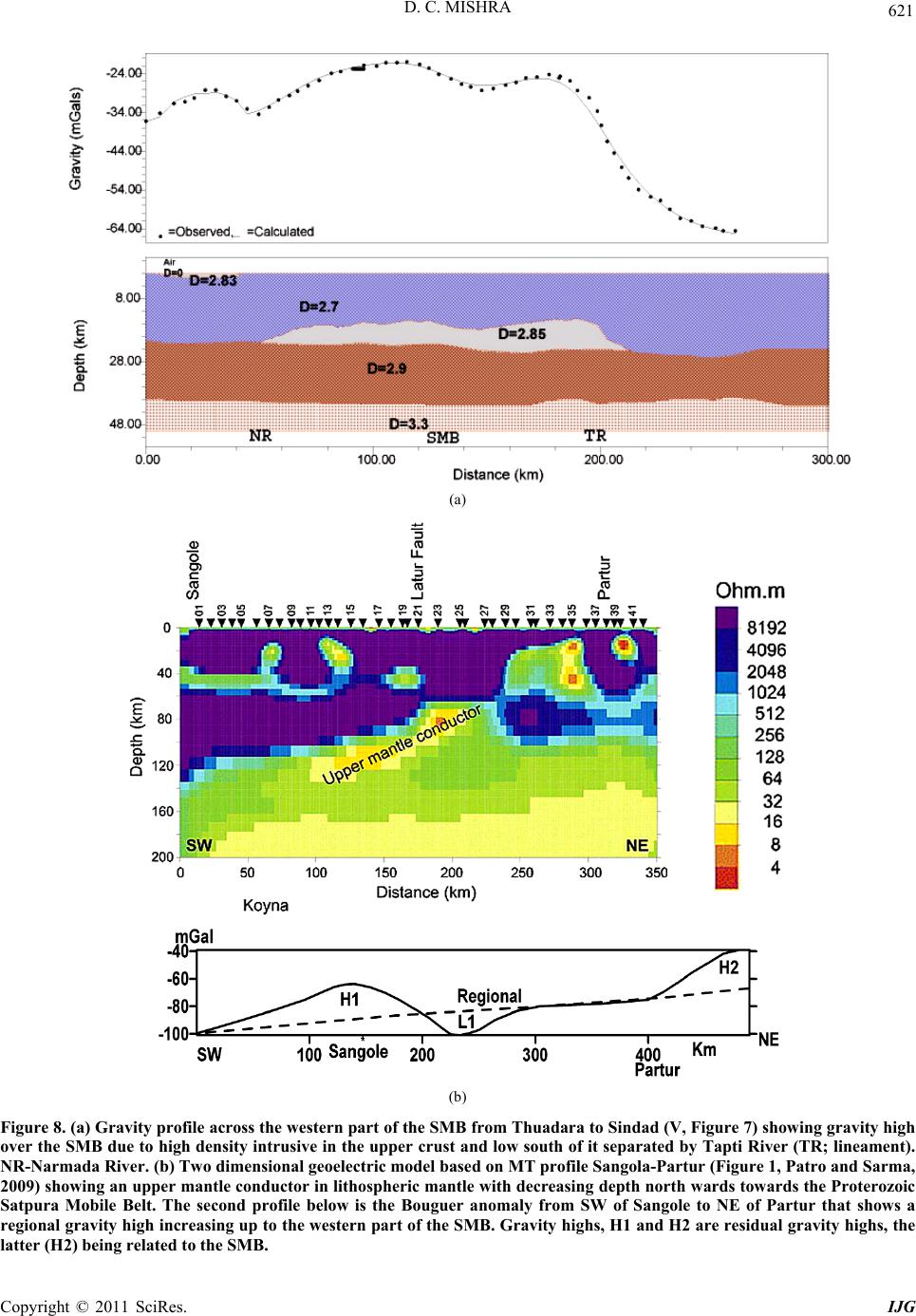 D. C. MISHRA Copyright © 2011 SciRes. IJG 621 (a) (b) Figure 8. (a) Gravity profile across the western part of the SMB from Thuadara to Sindad (V, Figure 7) showing gravity high over the SMB due to high density intrusive in the upper crust and low south of it separated by Tapti River (TR; lineament). NR-Narmada River. (b) Two dimensional geoelectric model based on MT profile Sangola-Partur (Figure 1, Patr o and Sarma, 2009) showing an upper mantle conductor in lithospheric mantle with decreasing depth north wards towards the Proterozoic Satpura Mobile Belt. The second profile below is the Bouguer anomaly from SW of Sangole to NE of Partur that shows a regional gravity high increasing up to the western part of the SMB. Gravity highs, H1 and H2 are residual gravity highs, the latter (H2) being related to the SMB.  D. C. MISHRA Copyright © 2011 SciRes. IJG 622 rocks contemporary to Bijawar and Mahakoshal Group of Rocks along the ADMB east of the Great Boundary Fault that formed the basement of the Vindhyan basin in this section over the rifted margins of the Bundelkhand craton [35]. 2) The gravity highs due to the SMB, H8 and H9 and ADMB, H14 form curvilinear mobile belt between the Bundelkhand craton in the central part and Rajasthan block towards the west and Dharwar-Bhandara-Singhb- hum cratons towards the south (Figures 1 and 7) with E- W convergence across the ADMB and N-S convergence across the SMB during Paleo-Mesoproterozoic periods with a rifting phase in between. 3) Contemporary N-S convergence of Bundelkhand craton across the SMB and its E-W convergence across the ADMB suggest primary stress direction as NE-SW with E-W and N-S components. It is supported by NW- SE oriented large lineaments and shear zones in the Bun- delkhand and the Dharwar cratons. 4.3. Godavari Proterozoic Belt (GPB) and Proterozoic Triple Junction It is defined by the gravity anomalies, H10-H11 and L10-L11 (Figures 1 and 2) that are discussed below. 1) This section is characterized by Gondwana (Per- mian-Triassic) sediments in the central part [49] flanked by Paleo-Neoproterozoic metasediments of Pakhal-Sul- lavai basins [50] that are exposed on either sides of the Godavari Gondwana graben (Figure 1). Figure 2 shows a central gravity low, L10 related to Gondwana sedi- ments flanked by gravity highs, H10 and H11 that coin- cides with the Paleo and Neoproterozoic metasediments of the Pakhal and Sullivai Group of Rocks along the shoulders. North of the exposed Proterozoic rocks is the Bhandara-Bastar craton that consists of several basins of Paleo-Mesoproterozoic period. The contact of Bhandara- Bastar craton with the Proterozoic metasediments of Go- davari Proterozoic Basin consists of Bhopalpatnam granulite belt of 1.6 Ga. The southern part of the Goda- vari Proterozoic basin is in contact with the Dharwar craton that is characterized by Karimnagar granulite belt of 2.4 - 2.2 Ga at its contact [51]. However, the latter (southern part) also shows a thermal event of 1.6 Ga that has been reported from Karimnagar dykes in the vicinity of the granulite belt [52] which is contemporary to Bho- palpatnam granulite belt. 2) A gravity profile (Figure 9(a)) across Chintalpudi sub basin in the southern part of the Godavari basin (H10, H11 and L10, Figure 2) is modeled constrained from seismic section [53] limited to the cen tral part of the pro- file (L10) that shows a high density layer in the upper crust (5 - 6 km) in the central part popping up along the shoulders supported from high seismic velocity in the central part. This may represent the thrusted lower crustal rocks that are exposed in some parts as Karimnagar and Bhopalpatnam granulite belt described above. 3) Airborne magnetic anomaly of large amplitude (~550 nT, Figure 9(b)) at a height of about 9000’ (~2.7 km a.m.s.l) along southern margin of the Proterozoic Pakhal group of rocks suggest mafic intrusive of high susceptibility 3.0 × 10⁻³ emu at a depth of about 5.3 km below m.s.l that is almost at same depth where high den- sity and high velocity rocks have been reported above and may represent thrusted mafic intrusive in the base- ment. The remanant magnetization of this body, Inclina- tion = –40˚ and declination = 300˚ required to match the observed and the computed field is typical of Paleo- Mesoproterozoic rocks [Vindhyan sediments, 54] in this region indicating the period of collision and thrusting. It is also similar to those reported for dykes of the same period in this region [52]. 4) Gravity highs over Proterozoic terrain caused by high density bodies in the upper crust and exposed gra- nulite lower crustal rocks (Bhopalpatnam granulite belt) and gravity lows over Archean craton (L11, Figure 2) suggest collision tectonics of Mesoproterozoic period between Bhandara-Bastar and Dharwar cratons that gave rise to this mobile belt with Bhopalpatnam granulite belt of this period and Sullavai metasediments of Meso- Neoproterozoic period along the GPB as r elated foreland basin. This convergence was approximately NE-SW di- rection, perpendicular to th e strike of the GPB that migh t be related to convergence along the SMB towards north of it as discussed above. Prior to it, there might be an- other phase of convergence and rifting during Paleopro- terozoic period similar to that along the SMB that gave rise to Karimnagar granulite belt of 2.2 - 2.4 Ga. Large scale mafic/ultramafic intrusive associated with the Pak- hal Group of rocks delineated from the airborne mag- netic anomaly as described above were responsible for rifting prior to Mesoproterozoic convergence when Pak- hal Group of rocks was deposited on the rifted platform of the adjoining cratons. 5) The two branches of the SMB viz the Western and the Central parts and the GPB (H8, H9 and H10 and H11, Figure 2) separating Bundelkhand craton towards the north and Bhandara-Bastar craton towards the SE and Dharwar craton towards the SW form a triple junctio n of Meso-Neoproterozoic period around Nagpur. 5. Eastern Ghat Mobile Belt and Cuddapah Basin They are defined by the gravity anomalies, H16-H20 and L16-L20 (Figures 1 and 2) that are discussed below 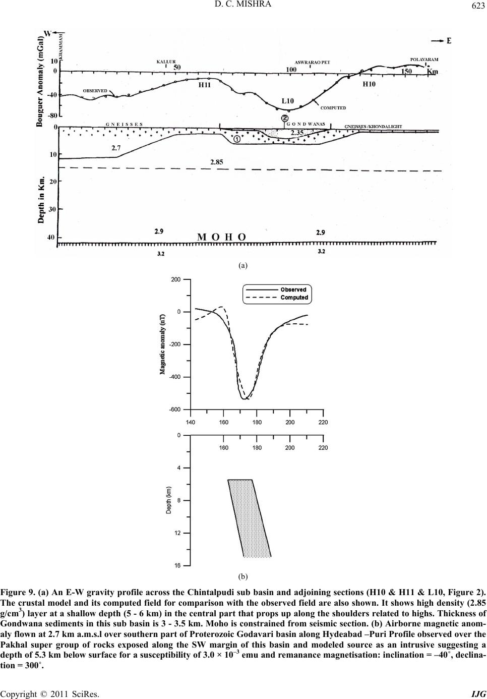 D. C. MISHRA Copyright © 2011 SciRes. IJG 623 (a) (b) Figure 9. (a) An E-W gravity profile across the Chintalpudi sub basin and adjoining sections (H10 & H11 & L10, Figure 2). The crustal model and its computed field for comparison with the observed field are also shown. It shows high density (2.85 g/cm3) layer at a shallow depth (5 - 6 km) in the central part that props up along the shoulders related to highs. Thickness of Gondwana sediments in this sub basin is 3 - 3.5 km. Moho is constr ained from seismic section. (b) Airborne magnetic anom- aly flown at 2.7 km a.m.s.l over southern part of Proterozoic Godavari basin along Hydeabad –Puri Profile observed over the Pakhal super group of rocks exposed along the SW margin of this basin and modeled source as an intrusive suggesting a depth of 5.3 km below sur face for a susc eptibility of 3.0 × 10 –3 emu and remanance magnetisation: inclination = –40˚, declina- tion = 300˚.  D. C. MISHRA Copyright © 2011 SciRes. IJG 624 1) High grade charnockite and khondalite rocks of the EGMB and intrusives have provided wide range of dates from 1.6 - 1.0 Ga [55] that are exposed from south of Bhubaneshwar to north of Chennai (Nellore). However, the most prominent metamorphic event in the EGMB is reported at 1.0 - 1.1 Ga [56]. The northern part of the EGMB consists of gneisses and migmatites with high grade granulite rocks of Meso-proterozoic period (1.6 - 1.5 Ga) [57], which are similar to those reported from the CGGC [58]. In fact, Dobmeier et al. [59] have provided dates of about 1.6 Ga of magma emplacement and low grade metamorphic overprint of 0.5 Ga related to Pan African event in the EGMB. Vijaya Kumar and Leelan- andam [60] have identified two stages of rifting and convergence in southern part of the EGMB, east of the Cuddapah basin du ri n g Paleo pr ot erozoic period (2.0 - 1.6 Ga) and Mesoproterozoic period (1.55 Ga) to Grenvil- lian/Pan African collision (1.0/0.5 Ga). The metasedi- ments of Cuddapah basin (Figure 1) abetting the EGMB in the southern part primarily consists of Cuddapah sper- group of rocks of Paleoproterozoic Period [~1.9 - 1.6 Ga, 61] in the eastern and the western parts of the basin (Horizontal lines, Figure 3) and Kurnool supergroup of rocks of Neoproterozoic period in the central part (bro- ken lines, Figure 3) that is considered mostly undis- turbed and free from any volcanic activity. The eastern part of the basin, known as Nallamalai sub basin along the EGMB is highly disturbed with several foldings and faultings and consists of metasediments with several acidic intrusives and lamprophyre dykes that are consid- ered younger than the rocks belonging to the same su- pergroup of rocks in the western part. The western mar- gin of Cuddapah basin is characterized by large mafic sills in Cuddapah supergroup of rocks that have been dated as 1885.4 3.1. Ma [62] indicating that sediments might be even older than this. They have also reported similar dates for some dykes from southern part of the Bastar craton along the northern part of the EGMB (Figure 1) suggesting the existence of a large igneous province at that time in this section. Cuddapah basin is also characterized by occurrences of several minerals such as base metals, barytes etc. including uranium min- eralization along the western margi n of the ba si n. 2) The EGMB is largely characterized by gravity highs along the east coast of India (H19-H21, Figure 3) which extends from south of Bhubaneshwar up to Chen- nai. These gravity highs are caused by high density rocks of 2.8 - 3.0 g/cm3 (Figure 10(b)). It is interesting to ob- serve that these highs, H19-H21 are accompanied by gravity low L19-L21 towards the west forming paired gravity anomalies that are significant for Proterozoic collision zone. The linear grav ity highs, H19-H21 extend southwards up to southern end along the east coast of India (H18) and northwards up to Himalaya (H22) along eastern margin of the CGGC where it interacts with the SMB (H15 and H16). 3) The gravity highs and lows, H17 and L17 west of the EGMB (Figure 2) in the southern part are related to the Cuddapah basin (Figure 3) occupied by metasedi- ments and mafic intrusives of Mesoproterozoic period. The gravity high, H17 is located where large mafic flows and sills are exposed while the gravity lows surrounding it coincide with felsic intrusives. The air borne total in- tensity map of the western part of Cuddapah basin re- corded at a terrain clearance of about 500’ (~152 m) with a profile spacing of 1 km [63,64] provided a complex picture of magnetic anomalies due to sev eral mafic intru- sives in the western part of Cuddapah basin as dykes and sills and metamorphosed sediments. The magnetic data west of Cuddapah basin was further complicated due to exposed gneisses and various intrusives that included both mafic dykes and granite batholiths. This data set was reprocessed by correcting for the earth’s geomag- netic reference field (IGRF) and filtered for the high frequency components due to surface/shallow bodies that provided a total intensity magnetic anomaly map of the western part of the Cuddapah basin (Figure 10(a)). This map broadly shows a magnetic low (L1) along the S-W margin of the Cuddapah basin with a magnetic high to- wards north (H1) and south (H2) of it. The amplitude and extent of these magnetic anomalies suggest a large igne- ous province under the sediments that has given rise to this set of magnetic anomalies, which might be responsi- ble for evolution of this basin. Size of the magnetic anomaly indicates that it may represent a large mafic intrusive in the basement of the western part of this ba- sin. 4) The airborne magnetic and gravity data along the eastern part of the deep seismic sounding profile I (Kavali-Udipi, Figure 3 ) across Cuddapah basin (Figure 10(b)) are simultaneously modeled constraining it from the seismic section [16]. This profile shows gravity highs, H1 and H2 (H17 and H19, Figure 2) related to the west- ern part of the cuddapah basin and the EGMB and inter- vening low, L1 (L19, Figure 3). The computed crustal model suggests a thrust T1 of high density under the EGMB and crustal thickening along with under plating (3.05 g/cc) under the eastern part of the Cuddapah basin, west of the EGMB. Thrusting due to this convergence is also supported from high conductivity in the crust re- ported from the eastern part of the basin [65]. It also suggests a large mafic intrusive (MI) in the basement of high susceptibility (0.002 emu) and remnant magnetiza- tion of inclination 6˚ and declination = 119˚ that is simi- lar to direction of magnetization of sills of Paleo-Meso- proterozoic period exposed in this region [66]. This is an 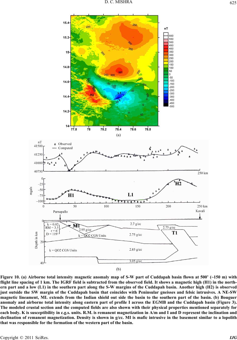 D. C. MISHRA Copyright © 2011 SciRes. IJG 625 (a) (b) Figure 10. (a) Airborne total intensity magnetic anomaly map of S-W part of Cuddapah basin flown at 500’ (~150 m) with flight line spacing of 1 km. The IGRF field is subtracted from the observed field. It shows a magnetic high (H1) in the north- ern part and a low (L1) in the southern part along the S-W margins of the Cuddapah basin. Another high (H2) is observed just outside the SW margin of the Cuddapah basin that coincides with Peninsular gneisses and felsic intrusives. A NE-SW magnetic lineament, ML extends from the Indian shield out side the basin to the southern part of the basin. (b) Bouguer anomaly and airborne total intensity along eastern part of profile I across the EGMB and the Cuddapah basin (Figure 3). The modeled crustal section and the computed fields ar e also shown with their phy sical properties mentioned separate ly for each body. K is susceptibility in c.g.s. units. R.M. is remanent magnetization in A/m and I and D represent the inclination and declination of remanent magnetization. Density is shown in g/cc. MI is mafic intrusive in the basement similar to a lopolith that was responsible for the formation of the western part of the basin. 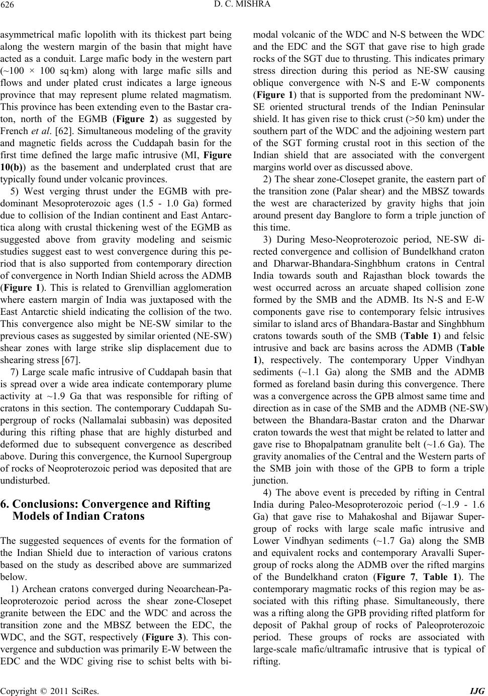 D. C. MISHRA Copyright © 2011 SciRes. IJG 626 asymmetrical mafic lopolith with its thickest part being along the western margin of the basin that might have acted as a conduit. Large mafic body in the western part (~100 × 100 sq·km) along with large mafic sills and flows and under plated crust indicates a large igneous province that may represent plume related magmatism. This province has b een extending even to the Bastar cra- ton, north of the EGMB (Figure 2) as suggested by French et al. [62]. Simultaneous modeling of the gravity and magnetic fields across the Cuddapah basin for the first time defined the large mafic intrusive (MI, Figure 10(b)) as the basement and underplated crust that are typically found under volcanic provinces. 5) West verging thrust under the EGMB with pre- dominant Mesoproterozoic ages (1.5 - 1.0 Ga) formed due to collision of the Indian continent and East Antarc- tica along with crustal thickening west of the EGMB as suggested above from gravity modeling and seismic studies suggest east to west convergence during this pe- riod that is also supported from contemporary direction of convergence in North Indian Shield across the ADMB (Figure 1). This is related to Grenvillian agglomeration where eastern margin of India was juxtaposed with the East Antarctic shield indicating the collision of the two. This convergence also might be NE-SW similar to the previous cases as suggested by similar oriented (NE-SW) shear zones with large strike slip displacement due to shearing stress [67]. 7) Large scale mafic intrusive of Cuddapah basin that is spread over a wide area indicate contemporary plume activity at ~1.9 Ga that was responsible for rifting of cratons in this section. The contemporary Cuddapah Su- pergroup of rocks (Nallamalai subbasin) was deposited during this rifting phase that are highly disturbed and deformed due to subsequent convergence as described above. During th is co nvergence, the Kurn ool Sup ergroup of rocks of Neoproterozoic per iod was deposited th at are undisturbed. 6. Conclusions: Convergence and Rifting Models of Indian Cratons The suggested sequences of events for the formation of the Indian Shield due to interaction of various cratons based on the study as described above are summarized below. 1) Archean cratons converged during Neoarchean-Pa- leoproterozoic period across the shear zone-Closepet granite between the EDC and the WDC and across the transition zone and the MBSZ between the EDC, the WDC, and the SGT, respectively (Figure 3). This con- vergence and su bduction was primarily E-W between the EDC and the WDC giving rise to schist belts with bi- modal volcanic of the WDC and N-S between the WDC and the EDC and the SGT that gave rise to high grade rocks of the SGT due to thrusting. This indicates primary stress direction during this period as NE-SW causing oblique convergence with N-S and E-W components (Figure 1) that is supported from the predominant NW- SE oriented structural trends of the Indian Peninsular shield. It has given rise to thick crust (>50 km) under the southern part of the WDC and the adjoining western part of the SGT forming crustal root in this section of the Indian shield that are associated with the convergent margins world over as discussed above. 2) The shear zone-Closepet granite, the eastern part of the transition zone (Palar shear) and the MBSZ towards the west are characterized by gravity highs that join around present day Banglore to form a triple junction of this time. 3) During Meso-Neoproterozoic period, NE-SW di- rected convergence and collision of Bundelkhand craton and Dharwar-Bhandara-Singhbhum cratons in Central India towards south and Rajasthan block towards the west occurred across an arcuate shaped collision zone formed by the SMB and the ADMB. Its N-S and E-W components gave rise to contemporary felsic intrusives similar to island arcs of Bhandara-Bastar and Singhbhum cratons towards south of the SMB (Table 1) and felsic intrusive and back arc basins across the ADMB (Table 1), respectively. The contemporary Upper Vindhyan sediments (~1.1 Ga) along the SMB and the ADMB formed as foreland basin during this convergence. There was a convergence across the GPB almost same time and direction as in case of the SMB and the ADMB (NE-SW) between the Bhandara-Bastar craton and the Dharwar craton towards the west that might be related to latter and gave rise to Bhopalpatnam granulite belt (~1.6 Ga). The gravity anomalies of the Central and the Western parts of the SMB join with those of the GPB to form a triple junction. 4) The above event is preceded by rifting in Central India during Paleo-Mesoproterozoic period (~1.9 - 1.6 Ga) that gave rise to Mahakoshal and Bijawar Super- group of rocks with large scale mafic intrusive and Lower Vindhyan sediments (~1.7 Ga) along the SMB and equivalent rocks and contemporary Aravalli Super- group of rocks along the ADMB over the rifted margins of the Bundelkhand craton (Figure 7, Table 1). The contemporary magmatic rocks of this region may be as- sociated with this rifting phase. Simultaneously, there was a rifting along the GPB providing rifted platform for deposit of Pakhal group of rocks of Paleoproterozoic period. These groups of rocks are associated with large-scale mafic/ultramafic intrusive that is typical of rifting.  D. C. MISHRA Copyright © 2011 SciRes. IJG 627 5) Simultaneous to Mesoproterozoic convergence across the ADMB and the SMB, there was a NE-SW to E-W convergence across the EGMB between the East Antarctica and the Indian shield (Figure 11) that gave rise to contemporary thrusted rocks of the EGMB and other deep seated intrusive that formed the Grenvillian agglomeration of Indian cratons and East Antarctica. NE-SW oriented shear zones and strike slip motion along them indicates that this convergence also might have been in NE-SW direction as in the previous cases. 6) Prior to this Mesoproterozoic convergence across the EGMB, there was a rifting phase during Paleo- Mesoproterozoic period (~1.9 - 1.5 Ga) that gave rise to large scale magmatism of Cuddapah basin and adjoining Bastar craton and Kondapalli layered compl ex (~1.7 Ga) of the EGMB that apparently was responsible for the break up of Dharwa r craton providing rifted platform for the formation of the several Proterozoic basins along the EGMB including the Cuddapah Super group of rocks. This break up might be related to the break up of Super- continent Columbia agglomeration in this section due to a plume that existed almost at the same time [68]. In fact, the same plume might have been wide spread that rifted the Indian cratons along the SMB, the ADMB and the GPB during the same period which also show contem- porary mafic/ultra mafic intrusive and contemporary basins were formed on rifted platform of cratons along these mobile belts as discussed above. Dates provided here for different periods are at the best approximate, as most of the rocks are not dated so far. More over, this is a general scheme and there may be some variations in various stages of these processes in different sections. 7) There are also indications of a Paleoproterozoic convergence across the EGMB, the SMB, the ADMB and the GPB almost in the same direction (NE-SW) prior to the above rifting (>1.9 Ga). Such a process across the EGMB would explain the formation of the Nellore and other schist belts of the EDC and related mafic and felsic Figure 11. A schematic section of the Mesoproterozoic colli- sion between the Indian cratons and East Antarctica along the EGMB that gave rise to this mobile belt and associated intrusive that gave rise to Cuddapah basin. E-W arrows indicate direction of convergence while opposite arrows indicate direction of thrusting. CB—Cuddapah Basin, EG—Eastern Ghat Mobile Belt, NC—Napier Complex. intrusive. It will also explains the Karimnagar granulite belt (2.4 - 2.2 Ga) across the GPB and various felsic in- trusive such as Dongargarh, Malanjkhand and Singhb- hum granite plutons across the SMB and Berach granite across the ADMB (Table 1). However, signatures of this convergence are not very clear. 8) In general the present study suggests repeated for- mation of agglomeration of Indian cratons and East Ant- arctica and their break up during Paleoproterozoic period (1.9 - 1.6 Ga) due to a plume followed by a NE-SW convergence during Meso-Neoproterozoic period. This convergence might have driven the other Indian cratons to converge and collide as their movements during this period were in same direction (Figure 1). In general, such repeated formations of Supercontinents and their break up during Neoarchean-Proterozoic period (2.7 - 1.0 Ga) have been suggeste d by Ernst [69] . 9) Signatures of platform deposits and foreland basins are absent from Archean collision zones indicating that they may represent the differences between the Protero- zoic and the Archean convergence and collision. The other difference lies in their elevation. Proterozoic fold belts are still observed as high lands while those of Ar- chean period are mostly peneplained plateaus with small variations in elevation and amalgamated to the adjoining cratons. 7. Acknowledgements Author is thankful to The Director, N.G.R.I and CSIR for Emeritus Scientist Scheme and to the Ministry of Earth Sciences for the project, MoES/PO(Seismo)/23(646)/ 2007. Thanks are also due to Mr M. Ravi Kumar for his help towards preparation of the manuscript. 8. References [1] R. A. Gibbs and M. D. Thomas, “Gravity Signature of Fossil Plate Boundaries in the Canadian Shield,” Nature, Vol. 262, No. 5565, 1976, pp. 199-200. doi:10.1038/262199a0 [2] D. M. Fountain and M. H. Salisbury, “Exposed Cross Section through the Continental Crust: Implications for Crustal Structure, Petrology and Evolution,” Earth and Planetary Science Letters, Vol.56, 1981, pp. 263-277. doi:10.1016/0012-821X(81)90133-3 [3] D. C. Mishra, “Building Blocks and Crustal Architecture of Indian Peninsular Shield Cratons and Fold Belts and Their Interaction Based on Geophysical Data Integrated with Geological Information,” Journal Geological Soci- ety of India, Vol. 68, No. 6, 2006, pp. 1037-1057. [4] GSI-NGRI, “Gravity Map Series of India” Geological Survey of India and National Geophysical Research In- stitute, Hyderabad, 2006.  D. C. MISHRA Copyright © 2011 SciRes. IJG 628 [5] D. C. Mishra, B. Singh and V. M. Tiwari, “Gravity Stud- ies in India,” Golden Jubilee, Volume of the Geological Society of India Golden Jubilee Memoir of Geological Society of India, 2008, pp. 329-372. [6] D. V. Subba Rao, “Resolving Bouguer Anomalies in Continents—A New Approach,” Geophysical Research Letters, Vol. 23, No. 24, 1996, pp. 3543-3546. doi:10.1029/96GL03471 [7] D. C. Mishra and L.B. Pedersen, “Statistical Analysis of Potential Fields from Subsurface Relief,” Geoexploration, Vol. 19, No. 4, 1982, pp. 247-265. doi:10.1016/0016-7142(82)90030-8 [8] A. P. Singh, D. C. Mishra and G. Laxman, “Apparent Density Mapping and 3-D Gravity Inversion of Dharwar Crustal Province,” Journal Indian Geophysical Union, Vol. 7, No. 1, 2003, pp. 1-9. [9] M. Jayananda , J. F.Moy a n, H. Martin, J. J. Peuc at, B. Au- vray and B. Mahabaleshwar, “Late Archean (2550-2520 Ma) Juvenile Magmatism in the Eastern Dharwar Craton, Southern India: Constraints from Geochronology, Nd-Sr Isotopes and Whole Rock Geochemistry,” Precambrian Research, Vol. 99, No. 3-4, 2000,pp. 225-254. doi:10.1016/S0301-9268(99)00063-7 [10] D. C. Mishra and S. K. Prajapati, “A Plausible Model for Evolution of Schist Belts and Granite Plutons of Dharwar craton, India and Madagascar during 3.0-2.5 Ga: Insight from Gravity Modelling Constrained in Part from Seismic Studies,” Gondwana Research, Vol. 6, No. 3, 2003, pp. 501-511. doi:10.1016/S1342-937X(05)71001-7 [11] B. Chadwick, V. N. Vasudev, G. V. Hegde and A. P. Nutman, “Structure and SHRIMP U/Pb Zircon Ages of Granites Adjacent to the Chitradurga Schist Belt: Impli- cations for Neoarchean Convergence in the Dharwar Craton, Southern India,” Journal Geological Society of India, Vol. 69, 2007, pp. 5-24. [12] A. Kumar, Y. J. Bhaskar Rao, T. V. Sivaraman and K. Gopalan, “Sm-Nd Ages of Archean Meta-Volcanics of the Dharwar Craton, South India,” Precambrian Re- search, Vol. 80, No. 3-4, 1996, pp. 205-216. doi:10.1016/S0301-9268(96)00015-0 [13] K. Arora, R. P. Rajasekhar and D. C. Mishra, “Density Models of Crust under Dharwar-Granite Greenstone Ter- rain and the Satpura Mobile Belt: Archean-Proterozoic Analogue of Plate Tectonics,” Memoir Gondwana Re- search, Vol. 10, 2007, pp. 217-226. [14] S. Kiselev, L.Vinnik, S. Oreshin, S. Gupta, S. S. Rai, A. Singh, M. R .Kumar and G. Mohan, “Lithosphere of the Dharwar Craton by Joint Inversion of P and S Receiver Functions,” Geophysical Journal International, Vol. 173, No. 3, 2008, pp. 1106-1118. doi:10.1111/j.1365-246X.2008.03777.x [15] S. Gupta, S. S. Rai, K. S. Prakasam and D. Srinagesh, “The Nature of the Crust in Southern India: Implications for Precambrian Crustal Evolution,” Geophysical Re- search Letters, Vol. 30, No. 8, 2003, p. 1419. doi:10.1029/2002GL0167 [16] K. L. Kaila, R. K. Chowdhury, P. R. Reddy, V. G. Krishna, H. Narain, S. I. Subbotin, V. B. Sollogulb, A. V. Chekunov, G. E. Kharetcho, M. A. Lazarenko and T. V. Ilchenko, “Crustal Structure along the Kavali-Udipi Pro- file in the Indian Peninsular Shield from Deep Seismic Sounding,” Journal of Geological Society of India, Vol. 20, 1979, pp. 307-333. [17] S. G., Gokaran, G. Gupta and C. K. Rao, “Geoelectric Structure of the Dharwar Craton from Magnetotelluric Studies: Archean Suture Identified along the Chitradurga- Gadag Schist Belt,” Geophysical Journal International, Vol. 158, No. 2, 2004, pp. 712-728. doi:10.1111/j.1365-246X.2004.02279.x [18] Y. J. B. Rao, A. S. Janardhan, T. V. Kumar, B. L. Nara- yana, A. M. Dayal, B. N. Taylor and T. R. K. Chetty, “Sm-Nd Model Ages and Rb-Sr Isotopic Systematics of Charnockites and Gneisses across the Cauvery Shear Zone, Southern India: Implications for the Archaean- Neoproterozoic Terranes Boundary in the Southern Granulie Terrain,” Memoir Geological Society of India, Vol. 50, 2003, pp. 297-317. [19] D. C. Mishra and V. V. Kumar, “Evidence for Protero- zoic Collision from Airborne Magnetic and Gravity Studies in Southern Granulite Terrain, India and signa- tures of Recent Tectonic Activity in the Palghat Gap,” Gondwana Research, Vol. 8, No. 1, 2005, pp. 1-12. doi:10.1016/S1342-937X(05)70261-6 [20] E. J. Krogstad, S. Balakrishnan, D. K. Mukhopadhyay, V. Rajamani, G. N. Hanson, “Plate tectonics, 2.5 billion yeas ago: Evidence at Kolar South India,” Science, Vol. 243, No. 4896, 1989, pp. 1337-1340. doi:10.1126/science.243.4896.1337 [21] P. R. Reddy, V. Vijayarao. B. R. Prasad, K. Sain, P. Prasad Rao and P. Khare, “Crustal Seismic Studies along Kuppam-Palani Transect in Southern Granulite Terrain,” Memoir Geological Society of India, Vol. 50, 2003, pp.79-106. [22] D. C. Mishra, V. Vijai Kumar and R. P. Rajasekhar, “Analysis of Airborne Magnetic and Gravity Anomalies of Peninsular Shield, India Integrated with Seismic and Magnetotelluric Results and Gravity Anomalies of Madagascar, Sri Lanka and East Antarctica,” Gondwana Research, Vol. 10, No. 1-2, 2006, pp. 6-17. doi:10.1016/j.gr.2005.11.014 [23] D. Canil, “Canada’s Craton: A Bottoms-Up View,” GSA Today, Vol. 18, 2008, pp. 4-10. doi:10.1130/GSAT01806A.1 [24] S. S. Schmidberger, A. Simonetti, L. M. Heaman, R. A. Creaserand and S. Whiteford, “Lu-Hf, in Situ Sr and Pb Isotope and Trace Element Systematics for Mantle Ec- logites from the Diavik Diamond Mine: Evidence for Pa- leo Proterozoic Subduction Beneath the Slave Craton,” Earth and Planetary Science Letters, Vol. 254, No. 1-2, 2007, pp. 55-68. doi:10.1016/j.epsl.2006.11.020 [25] M. Santosh, S. Maruyama and K. Sato, “Anatomy of a Cambrian Suture in Gondwana: Pacific Type Orogeny in Southern India,” Gondwana Research, Vol. 16, No. 2, 2009, pp.321-341. doi:10.1016/j.gr.2008.12.012 [26] K. Naganjaneyulu and M. Santosh, “The Cambrian Colli-  D. C. MISHRA Copyright © 2011 SciRes. IJG 629 sional Suture of Gondwana in Southern India: A Geo- physical Appraisal,” Journal of Geodynamics, Vol. 50, No. 3-4, 2010, pp. 256-267. doi:10.1016/j.jog.2009.12.001 [27] U. Raval and K. Veeraswamy, “Within and beyond the Protocontinents: Some Geophysical Aspects Reflecting Geodynamics of the Indian Continental Lithosphere,” Memoir Gondwana Research, Vol. 10, 2007, pp. 263- 285. [28] GSI, “Geological Map of India on 1: 5 Million Scale,” Geological Survey of India, Calcatta, 1993. [29] D. H. Yedekar, S. C. Jain, K. K. K. Nair and K. K. Dutta, “The Central Indian Collision Suture. In: Precambrian of Central India,” Geological Survey of India, Special Pub- lication, Nagpur, Vol. 28, 1990, pp. 1-43. [30] S. Sinha-Roy, “Proterozoic Wilson Cycle in Rajasthan,” Memoir Gological Society of India, Vol. 7, 1988, pp. 95- 108. [31] D. C. Mishra, B. Singh, V. M. Tiwari S. B. Gupta and M. B. S. V. Rao, “Two Cases of Continental Collisions and Related Tectonics during the Proterozoic Period In In- dia-Insights from Gravity Modelling Constrained by Seismic and Magnetotelluric Studies,” Precambrian Re- search, Vol. 99, No. 3-4, 2000, pp. 149-169. doi:10.1016/S0301-9268(99)00037-6 [32] A. P. Singh, D. C. Mishra, V. V. Kumar and M. B. S. V. Rao, “Gravity-Magnetic Signatures and Crustal Archi- tecture along Kuppam-Palani Geotransect, South India”. Memoir Geological Society of India, Vol. 50, 2003, pp. 139-163. [33] P. R. Reddy, P. R. K. Murthy Rao, I. B. P. D. M. Mall and P. Koteshwar Rao, “Coincident Deep Seismic Re- flection and Refraction Profiling of Central India,” Re- search Highlights in Earth System Science, DST Special Volume 1, Indian Geological Congress, 2000, pp. 49-53. [34] R. P. Rajasekhar and D. C. Mishra, “Crustal Structure of Bengal Basin and Shillong Plateau: Extension of Eastern Ghat and Satpura Mobile Belts to Himalayan Fronts and Seismotectonics,” Gondwana Research, Vol. 14, No. 3, 2008, pp. 523-534. doi:10.1016/j.gr.2007.10.009 [35] D. C. Mishra and R. P. Rajasekhar, “Gravity and Mag- netic Signatures of Proterozoic Rifted Margins: Bun- delkhand Craton and Bijawar and Mahakoshal Group of Rocks and Vindhyan Basin and Their Extension under Ganga Basin,” Journal of Geological Society of India, Vol. 71, 2008, pp. 377-387. [36] K. Sain, N. Bruguier, A. S. N. Murthy and P. R. Reddy, “Shallow Velocity Structure along Hirapur-Mandla Pro- file Using Travel Time Inversion of Wide Angle Seismic Data and Its Tectonic Implications,” Geophysical Journal International, Vol. 142, No. 2, 2000, pp. 505-515. doi:10.1046/j.1365-246x.2000.00176.x [37] J. S. Ray, J. Veizer, W. J. Davis, “C, O, Sr and Pb Isotope systematics of Carbonate Sequences of the Vindhyan Supergroup, India: Age, Diagenesis, Correlations and Implications for Global Events,” Precambrian Research, Vol. 121, No. 1-2, 2003, pp. 103-140. doi:10.1016/S0301-9268(02)00223-1 [38] J. S. Ray, M. W. Martin, J. Veizer and S. A. Bowring, “U-Pb Zircon Dating and Sr Isotope Systematics of the Vindhyan Supergroup, India,” Geology, Vol. 30, No. 2, 2002, pp. 131-134. doi:10.1130/0091-7613(2002)030<0131:UPZDAS>2.0.C O;2 [39] D. C. Mishra, “Long hiatus in Proterozoic Sedimentation in India: Vindhyan, Cuddapah and Pakhal Basins—A Plate Tectonics Model,” Journal of Geological Society of India, Vol. 77, No. 1, 2011, pp. 17-25. doi:10.1007/s12594-011-0004-9 [40] D. C. Mishra, “Gravity and Magnetic Methods for Geo- logical Studies (Principles Integrated Exploration and Plate Tectonics),” B. S. Publications, Hyderabad & CRC Press, Boca Raton, 2011, pp. 1-938. [41] A. Roy and M. H. Prasad, “Tectonothermal Events in Central Indian Tectonic Zone (CITZ) and Its Implications in Rodinian Crustal Assembly,” Journal of Asian Earth Sciences, Vol. 22, No. 2, 2003, pp. 115-129. doi:10.1016/S1367-9120(02)00180-3 [42] K. Naganjaneyulu and M. Santosh, “The Central India Tectonic Zone: A Geophysical Perspective on Continen- tal Amalgamation along a Meso Proterozoic Suture,” Gondwana Research, Vol. 18, No. 4, 2010, pp. 547-564, doi:10.1016/j.gr.2010.02.017 [43] S. Majumder and M. A. Mamtani, “Magnetic Fabric in the Malanjkhand Granite (Central India)—Implications for regional Tectonics and Proterozoic Suturing of the In- dian Shield,” Physics of the Earth and Planetary Interiors, Vol. 172, No. 3-4, 2009, pp. 310-323. doi:10.1016/j.pepi.2008.10.007 [44] A. R. Sridhar, H. C. Tewari, V. Vijaya Rao, N. Satavani, N. K. Thakur, “Crustal Velocity Structure of the Narmada Son Lineament along the Thuadara-Sendhwa-Sindad pro- file in the NW Part of Central India and Its Geodynamic Implications,” Journal Geological Society of India, Vol. 69, 2007, pp. 1147-1160. [45] C. K. Rao, S. G. Gokaran and B. P. Singh, “Upper Crustal Structure in the Torni-Purnad Region, Central In- dia Using Magnetotelluric Studies,” Journal Geomagne- tism and Geoelectricity, Vol. 47, No. 4, 1995, pp. 411- 420. doi:10.5636/jgg.47.411 [46] P. K. Patro and S. V. S. Sarma, “Lithospheric Electrical Imaging of the Deccan Trap Covered Region of Western India,” Journal of Geophysical Research, Vol. 114, 2009, pp. B01102-B01118. doi:10.1029/2007JB005572 [47] S. A. Chore and M. Mohanty, “Stratigraphy and Tectonic Setting of the Trans Aravalli, Neoproterozoic Volcano Sedimentary Sequence in Rajasthan,” Journal Geological Society of India, Vol. 51, 1998, pp. 57-68. [48] B. V. Lente, L. D. Ashwal, M. K. Pandit, S. A. Bowring and T. H. Torsvik, “Neoproterozoic Hydrothermally Al- tered Basaltic Rocks from Rajasthan, Northwest India: Implications for Late Precambrian Tectonic Evolution of the Aravalli Craton,” Precambrian Research, Vol. 170, No. 3-4, 2009, pp. 202-222.  D. C. MISHRA Copyright © 2011 SciRes. IJG 630 doi:10.1016/j.precamres.2009.01.007 [49] P. S. R. Raju, “Geology and Hydrocarbon Prospects of Pranhita-Godavari Graben,” Journal of Association of Exploration Geophysics, Vol. 7, No. 3, 1986, pp. 131- 146. [50] T. S. Rao, “The Pakhal Basin; A perspective. In: Purana Basins of Peninsular India, Middle to Late Proterozoic Based on the Proceedings of the Seminar,” Memoir Geo- logical Society of India, Vol. 6, 1987, pp. 161-187. [51] M. Santosh, K. Yokoyama and S. K. Acharyya, “Geo- chronology and Tectonic Evolution of Karimnagar and Bhopalpatnam Granulite Belts, Central India,” Gondwana Research, Vol. 7, No. 2, 2004, pp. 501-518. doi:10.1016/S1342-937X(05)70801-7 [52] J. M. Rao, G. V. S. P Rao and S. K. Patil, “Geochemical and Paleomagnetic Studies on the Middle Proterozoic Karimnagar Mafic Dyke Swarm, India,” In: A. P. Parker, P. C. Rock Wood and D. H. Tucker, A. A. Balkema, Eds., Rotterdam Mafic Dykes and Emplacement Mechanism, Balkema, Rotterdam, 1990, pp. 373-382. [53] K. L. Kaila, P. R. K. Murthy, V. K. Rao and N. Venkates- warlu, “Deep Seismic Sounding in the Godavari Graben and Godavari (Coastal) Basin, India,” Tectonophysics, Vol. 173, 1990, pp. 307-317. doi:10.1016/0040-1951(90)90226-X [54] D. C. Mishra, “Paleomagnetism of variation Rocks of India,” Ph.D. Thesis, Banaras Hindu university, Banaras, 1965, [55] K. Mezger and M. A. Cosca, “The Thermal History of the Eastern Ghats Belts (India) as Revealed by U-Pb and (su- per 40) Ar/(Super 39) A Dating of Metamorphic and Magmatic Minerals: Implications for the SWEAT Corre- lation,” Precambrian Research, Vol. 94, No. 3-4, 1999, pp. 251-271. doi:10.1016/S0301-9268(98)00118-1 [56] D. K. Paul, T. Barman, N. J. McNaughton, I. R. Flecther, P. J. Potts, M. Ramakrishnan and P. F. Augustine, “Ar- chean-Proterozoic Evolution of Indian Charnockites-Iso- Topes and Geochemical Evidence from Granulites of the Eastern Ghat Belt,” Journal of Geology, Vol. 98, No. 2, 1990, pp. 253-263. doi:10.1086/629396 [57] C. J. Dobmeier and M. Raith, “Crustal Architecture and Evolution of the Eastern Ghats Belt and Adjacent Re- gions of India,” In: M. Yoshida, B. F. Windley, S. Das- gupta, Eds., Proterozoic East Gondwana: Super continent Assembly and Break up, Geological Society, Special Pub- lications, London, Vol. 206, 2003, pp. 145-168. [58] S. K. Acharyya, “A Plate Tectonic Model for Proterozoic Crustal Evolution of Central Indian Tectonic Zone, Gond,” Geological Magazine, Vol. 7, 2003, pp. 9-31. [59] C. J. Dobmeier, S. Lutke, K. Hammerschmidt and K. Mezger, “Emplacement and Deformation of the Vinukon- da Meta-Granite (Eastern Ghats, India: Implications for the Geological Evolution of Peninsular India and for Rodinia Reconstructions,” Precambrian Research, Vol. 146, No. 3-4, 2006, pp. 165-178. doi:10.1016/j.precamres.2006.01.011 [60] K. V. Kumar and C. Leelanandam, “Evolution of the Eastern Ghats Belt, India: A Plate Tectonic Perspective,” Journal of the Geological Society of India, Vol. 72, No. 6, 2008, pp. 720-759. [61] B. K. Nagaraja Rao, S. T. Rajurkar, G. Ramlingaswamy and B. R. Babu, “Stratigraphy, Structure and Evolution of the Cuddapah Basin,” Memoir Geological Society of In- dia, Vol. 6, 1987, pp. 33-87. [62] J. E. French, L. M. Heaman, T. Chacko and R. K. Srivastava, “1891-1883 Ma Southern Bastar-Cuddapah Mafic Igneous Event, India: A Newly Recognized Large Igneous Province,” Precambrian Research, Vol. 160, No. 3-4, 2008, pp. 308-322. doi:10.1016/j.precamres.2007.08.005 [63] V. B. Rao, Y. Sreedhar Murthy and K. Govindarajan, “Contours to Images-Part II: Aeromagnetic Image of Western Part of Cuddapah Basin and Adjoining Crystal- lines—A Case Study,” Journal of Geophysics, Vol. 19, 1998, pp. 195-203. [64] D. C. Mishra, V. Babu Rao, G. Laxman, M. B. S. V. Rao and M. Venkatarayudu, “Three-Dimensional Structural Model of Cuddapah Basin and Adjacent Eastern Part from Geophysical Studies,” Memoir Geological Society of India, Vol. 6, 1987, pp. 313-330. [65] K. Naganjaneyulu and T. Harinarayana, “Deep Crustal Electrical Signatures of Eastern Dharwar Craton, India,” Gondwana Research, Vol. 7, No. 4, 2004, pp. 951-960. doi:10.1016/S1342-937X(05)71077-7 [66] D. C. Mishra and V. M. Tiwari, “An Asymmetrica l Basic Lopolith below Sediments in Western Cuddapah Ba- sin—Geophysical evidence, Proc. Annual Convention of Geological Society of India,” University of Tirupati, Ti- rupati, 1995, 31-41. [67] T. R. K. Chetty, “The Eastern Ghats Mobile Belt, India: A Collage of Juxtaposed Terranes (?),” Gondwana Re- seach, Vol. 4, No. 3, 2001, pp. 319-328. doi:10.1016/S1342-937X(05)70332-4 [68] J. J. W. Rogers and M. Santosh, “Tectonics and Surface Effects of the Supercontinent Columbia,” Gondwana Re- search, Vol. 15, No. 3-4, 2009, pp. 373-380. doi:10.1016/j.gr.2008.06.008 [69] W. G. Ernst, “Archean Plate Tectonics, Rise of Protero- zoic Supercontinentality and Onset of Regional, Episodic Stagnant-Lid Behavior,” Gondwana Research, Vol. 15, No. 3-4, 2009, pp. 243-253. doi:10.1016/j.gr.2008.06.010 [70] S. N. Sarkar, K. Gopalan and J. R. Trivedi, “New Data on the Geochronology of the Precambrians of Bhan- dara-Drug, Central India,” Indian Journal of Earth Sci- ence, Vol. 8, No. 2, 1981, pp. 131-151. |