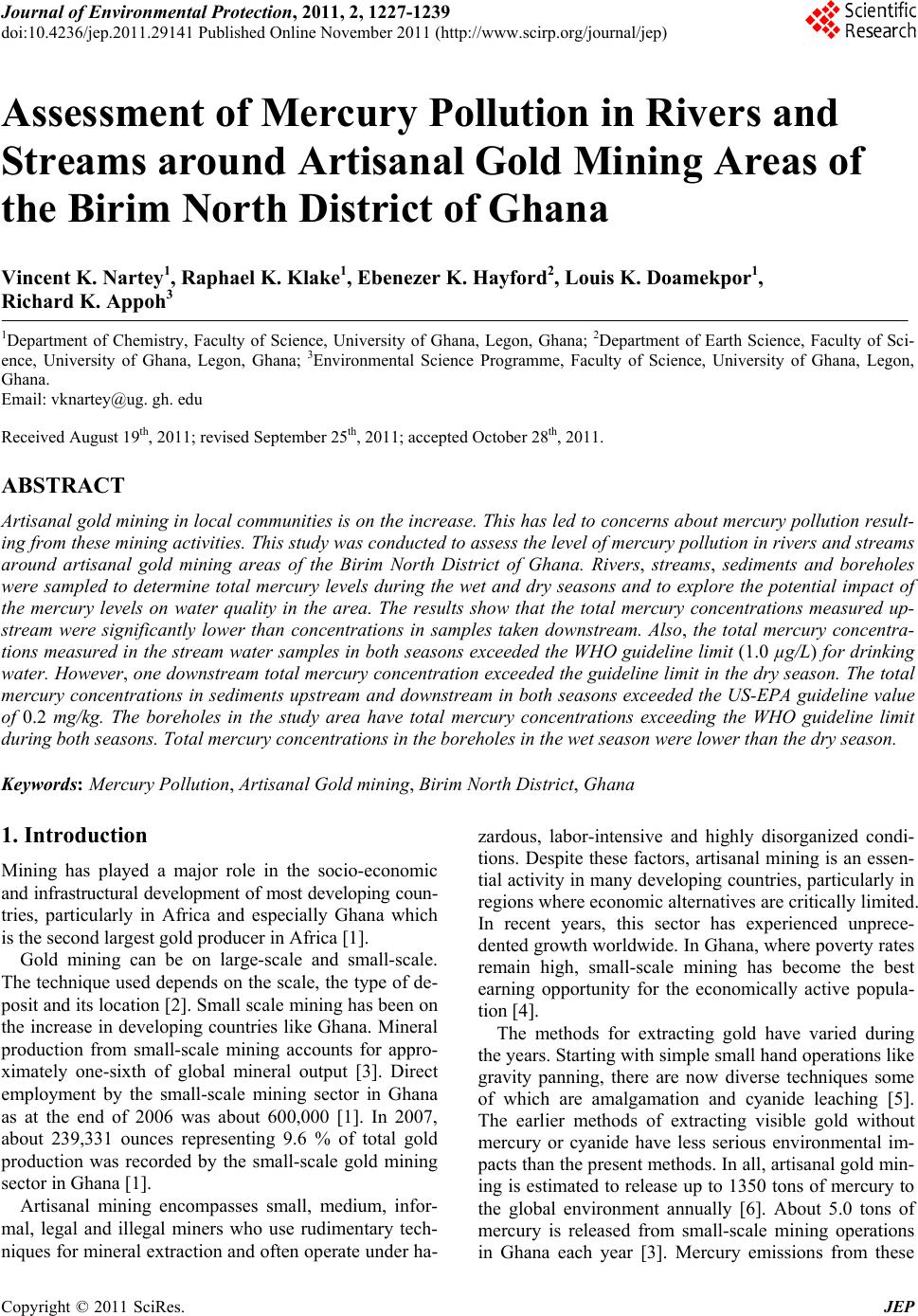
 Journal of Environmental Protection, 2011, 2, 1227-1239 doi:10.4236/jep.2011.29141 Published Online November 2011 (http://www.scirp.org/journal/jep) Copyright © 2011 SciRes. JEP Assessment of Mercury Pollution in Rivers and Streams around Artisanal Gold Mining Areas of the Birim North District of Ghana Vincent K. Nartey1, Raphael K. Klake1, Ebenezer K. Hayford2, Louis K. Doamekpor1, Richard K. Appoh3 1Department of Chemistry, Faculty of Science, University of Ghana, Legon, Ghana; 2Department of Earth Science, Faculty of Sci- ence, University of Ghana, Legon, Ghana; 3Environmental Science Programme, Faculty of Science, University of Ghana, Legon, Ghana. Email: vknartey@ug. gh. edu Received August 19th, 2011; revised September 25th, 2011; accepted October 28th, 2011. ABSTRACT Artisanal gold mining in local communities is on the increase . This has led to concern s about mercury pollution result- ing from these mining activities. This study was conducted to assess the level of mercury pollution in rivers and streams around artisanal gold mining areas of the Birim North District of Ghana. Rivers, streams, sediments and boreholes were sampled to determine total mercury levels during the wet and dry seasons and to explore the potential impact of the mercury levels on water quality in the area. The results show that the total mercury concentrations measured up- stream were significantly lower than concentrations in samples taken downstream. Also, the total mercury concentra- tions measured in the stream water samples in both seasons exceeded the WHO guideline limit (1.0 µg/L) for drinking water. However, one downstream total mercury concentration exceeded the guideline limit in the dry season. The total mercury concentrations in sediments upstream and downstream in both seasons exceeded the US-EPA guideline value of 0.2 mg/kg. The boreholes in the study area have total mercury concentrations exceeding the WHO guideline limit during both seasons. Total mercury concentrations in the boreholes in the wet season were lower than the dry season. Keywords: Mercury Pollution, Artisanal Gold mining, Birim North District, Ghana 1. Introduction Mining has played a major role in the socio-economic and infrastructural development of most developing coun- tries, particularly in Africa and especially Ghana which is the second largest gold producer in Africa [1]. Gold mining can be on large-scale and small-scale. The technique used depends on the scale, the type of de- posit and its location [2]. Small scale mining has been on the increase in developing countries like Ghana. Mineral production from small-scale mining accounts for appro- ximately one-sixth of global mineral output [3]. Direct employment by the small-scale mining sector in Ghana as at the end of 2006 was about 600,000 [1]. In 2007, about 239,331 ounces representing 9.6 % of total gold production was recorded by the small-scale gold mining sector in Ghana [1]. Artisanal mining encompasses small, medium, infor- mal, legal and illegal miners who use rudimentary tech- niques for mineral extraction and often operate under ha- zardous, labor-intensive and highly disorganized condi- tions. Despite these factors, artisanal mining is an essen- tial activity in many de veloping countries, particularly in regions where economic alternatives are critically limited. In recent years, this sector has experienced unprece- dented growth worldwide. In Ghana, where poverty rates remain high, small-scale mining has become the best earning opportunity for the economically active popula- tion [4]. The methods for extracting gold have varied during the years. Starting with simple small hand op erations like gravity panning, there are now diverse techniques some of which are amalgamation and cyanide leaching [5]. The earlier methods of extracting visible gold without mercury or cyanide have less serious environmental im- pacts than the present methods. In all, artisanal gold min- ing is estimated to release up to 1350 tons of mercury to the global environment annually [6]. About 5.0 tons of mercury is released from small-scale mining operations in Ghana each year [3]. Mercury emissions from these 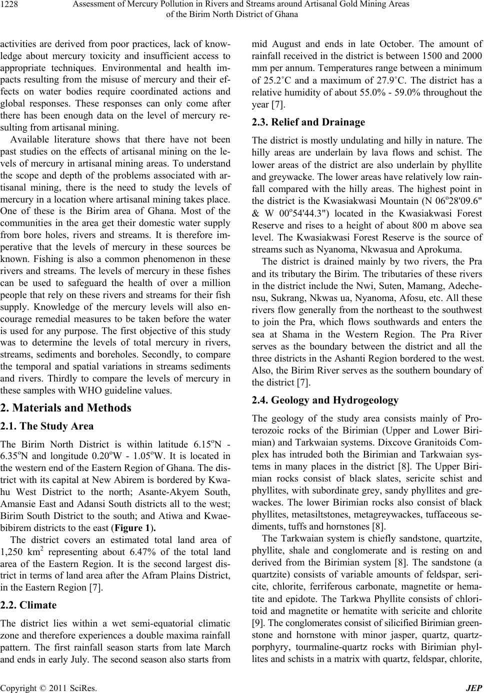 Assessment of Mercury Pollution in Rivers and Streams around Artisanal Gold Mining Areas 1228 of the Birim North District of Ghana activities are derived from poor practices, lack of know- ledge about mercury toxicity and insufficient access to appropriate techniques. Environmental and health im- pacts resulting from the misuse of mercury and their ef- fects on water bodies require coordinated actions and global responses. These responses can only come after there has been enough data on the level of mercury re- sulting from artisanal mining. Available literature shows that there have not been past studies on the effects of artisanal mining on the le- vels of mercury in artisanal mining areas. To understand the scope and depth of the problems associated with ar- tisanal mining, there is the need to study the levels of mercury in a location where artisanal mining takes place. One of these is the Birim area of Ghana. Most of the communities in the area get their domestic water supply from bore holes, rivers and streams. It is therefore im- perative that the levels of mercury in these sources be known. Fishing is also a common phenomenon in these rivers and streams. The levels of mercury in these fishes can be used to safeguard the health of over a million people that rely on these rivers and streams for their fish supply. Knowledge of the mercury levels will also en- courage remedial measures to be taken before the water is used for any purpose. The first objective of this study was to determine the levels of total mercury in rivers, streams, sediments and boreholes. Secondly, to compare the temporal and spatial variations in streams sediments and rivers. Thirdly to compare the levels of mercury in these samples with WHO guideline values. 2. Materials and Methods 2.1. The Study Area The Birim North District is within latitude 6.15oN - 6.35oN and longitude 0.20oW - 1.05oW. It is located in the western end of the Eastern Region of Ghana. The dis- trict with its capital at New Abirem is bordered by Kwa- hu West District to the north; Asante-Akyem South, Amansie East and Adansi South districts all to the west; Birim South District to the south; and Atiwa and Kwae- bibirem districts to the east (Figure 1). The district covers an estimated total land area of 1,250 km2 representing about 6.47% of the total land area of the Eastern Region. It is the second largest dis- trict in terms of land area after the Afram Plains District, in the Eastern Region [7]. 2.2. Climate The district lies within a wet semi-equatorial climatic zone and therefore experiences a double maxima rainfall pattern. The first rainfall season starts from late March and ends in early July. The second season also starts from mid August and ends in late October. The amount of rainfall received in the district is between 1500 and 2000 mm per annum. Temperatures range between a minimum of 25.2˚C and a maximum of 27.9˚C. The district has a relative humidity of abou t 55.0% - 59.0% throughout the year [7]. 2.3. Relief and Drainage The district is mostly u ndulating and hilly in na ture. The hilly areas are underlain by lava flows and schist. The lower areas of the district are also underlain by phyllite and greywacke. The lower areas have relatively low rain- fall compared with the hilly areas. The highest point in the district is the Kwasiakwasi Mountain (N 06o28'09.6" & W 00o54'44.3") located in the Kwasiakwasi Forest Reserve and rises to a height of about 800 m above sea level. The Kwasiakwasi Forest Reserve is the source of streams such as Nyanoma, Nkwasua and Aprokuma. The district is drained mainly by two rivers, the Pra and its tributary the Birim. The tributaries of these rivers in the district include the Nwi, Suten, Maman g, Adeche- nsu, Sukrang, Nkwas ua, Nyanoma, Afosu, etc. All these rivers flow generally from the northeast to the southwest to join the Pra, which flows southwards and enters the sea at Shama in the Western Region. The Pra River serves as the boundary between the district and all the three districts in the Ashanti Region bord ered to the west. Also, the Birim Rive r serves as the southe rn boundary of the district [7]. 2.4. Geology and Hydrogeology The geology of the study area consists mainly of Pro- terozoic rocks of the Birimian (Upper and Lower Biri- mian) and Tarkwaian systems. Dixcove Granitoids Com- plex has intruded both the Birimian and Tarkwaian sys- tems in many places in the district [8]. The Upper Biri- mian rocks consist of black slates, sericite schist and phyllites, with subordinate grey, sandy phyllites and gre- wackes. The lower Birimian rocks also consist of black phyllites, metasiltstones, metagreywackes, tuffaceous se- diments, tuffs and hornstones [8]. The Tarkwaian system is chiefly sandstone, quartzite, phyllite, shale and conglomerate and is resting on and derived from the Birimian system [8]. The sandstone (a quartzite) consists of variable amounts of feldspar, seri- cite, chlorite, ferriferous carbonate, magnetite or hema- tite and epidote. The Tarkwa Phyllite consists of chlori- toid and magnetite or hematite with sericite and chlorite [9]. The conglomerates consist of silicified Birimian green- stone and hornstone with minor jasper, quartz, quartz- porphyry, tourmaline-quartz rocks with Birimian phyl- lites and schists in a matrix w ith q uartz, feldspar, ch lorite, C opyright © 2011 SciRes. JEP  Assessment of Mercury Pollution in Rivers and Streams around Artisanal Gold Mining Areas of the Birim North District of Ghana Copyright © 2011 SciRes. JEP 1229 Figure 1. Map of the Study Area.  Assessment of Mercury Pollution in Rivers and Streams around Artisanal Gold Mining Areas 1230 of the Birim North District of Ghana carbonate, epidote, magnetite, chert and gondite [9]. The district lies almost wholly in the main mine ral de- posit area of the Eastern Region, accounting for the many small scale mining operations in gold and diamond. Groundwater is the main source of domestic water sup- ply in the study area. Most of the towns/villages rely on groundwater with the exception of New Abirem and Afosu where surface water taken from the Pra and Afosu Rivers is treated and distributed. The underground water reserve is rich, despite the scarcity and inadequacy of potable water in many communities. Borehole yields in the study area are in the range of 1 - 5 m3/hr. The rock underlying the area lack primary porosity since they are crystalline. Groundwater occurrence is therefore associ- ated with the development of second ary porosity through fissuring and weathering. Groundwater circulation in the study area is mainly localized due to the numerous mountains and hills that act as groundwater divides. Its flow is therefore mostly restricted to joints, fractures or other openings within the crystalline rock formations. In general, there are two types of aquifers: weathered rock aquifers and fractured rock aquifers. These aquifers tend to be either confined or semi-confined. Groundwater in the mining area is known to be vulnerable to pollution from mining and this may have serious effect on human health. 2.5. Sampling Sites Even though the Birim North District has many rivers and streams, the artisanal gold mining areas where the study was conducted is drained by the Pra, Nwi, Suten, Sereman, Nyanoma, Nkwasua, Aprokuma and Tainsu ri- vers. Out of these, Pra, Nwi, Suten, Nyanoma, Nkwasua and Tainsu were selected because of their strategic loca- tions in relation to the artisanal mining activities and their potential impact on domestic water supply in the area. The six boreholes sampled are located in the areas affected mostly by the mining activities. The sampling sites were given different designations as shown in Ta- ble 1. All the bore- holes have yields ranging from 1 - 3 m3/hr (Figure 2). 2.6. Sampling Methodology Environmental Data Sampling Sampling was designed to cover a 12 month period. The samples were collected between the months of April, 2009 and February, 2010. April, June and August were considered wet periods whilst October, December and February were considered as dry periods even though some rains occurred in the month of February. Water and sediment sampling points were immedi- ately upstream of the artisanal gold mining areas and near discharge areas of all the rivers/streams. The sam- pling points upstream of the artisanal gold mining areas were located at least 2 km from the artisanal gold mining area to prevent any possible contamination. The sam- pling points near the discharge areas were also located about 100 m upstream of the junction with the receiving water body. In the case of River Nwi, a first order tribu- tary of River Pra, samples were taken about 1km up- stream of its first tributary in the mining area and also 100 m upstream of the confluence with River Pra. Water and sediment samples from River Pra were taken about 2 km upstream before it enters the mining area and about 2 km downstream of the mining area. Two boreholes were selected at each mining town/village and water samples taken. At each river/stream sampling point, about 300 cm3 of water were taken from the centre of the stream/river at a depth of about 10 to 20 cm below the water surface. Sediment samples weighing about 300 g were also scooped below the water surface from the centre of the stream/ river. These were cleaned of wood pieces, pebbles, shells, leaves, etc. The borehole water samples were collected directly from the well heads. The borehole pipe should have been emptied by pumping before taking the sample but because these boreholes are almost continuously working throughout the day, the samples were collected directly. The water samples were kept in pre-labelled polypropylene bottles which have been rinsed with 10.0% HNO3. About 3 cm3 of concentrated HNO3 was added to the water samples before its cap was fitted in order to stabilize the mercury content, because trace mercury is relatively stable at lower pH [10]. The sedi- ment samples were put in pre-labelled transparent poly- thene bags. The bags were tied, put into a second poly- thene bag and sealed with duct tape. All the samples were stored in an ice chest with ice to maintain a low temperature (<4˚C) during transportation to the Envi- ronmental Chemistry Laboratory of the Water Research Institute for total mercury analysis. 2.7. Laboratory Analyses The laboratory analyses were undertaken according to procedures outlined by APHA, AWWA and WEF 1998) [11]. Total mercury analysis was done at the Environ- mental Chemistry Laboratory of the Water Research In- stitute by Cold-Vapour Atomic Absorption Spectroscopy (CVAAS). 2.7.1. Water Analyses About 100 cm3 each of the water samples was transferred into 125 cm3 conical flask. Approximately 5 cm3 of con- centrated HNO3 was added and heated in a water bath at 95˚C for about one hour. It was filtered, cooled and transferred into a 100 cm3 volumetric flask and diluted to the mark. A working solution of 0.1 mg/L was prepared C opyright © 2011 SciRes. JEP 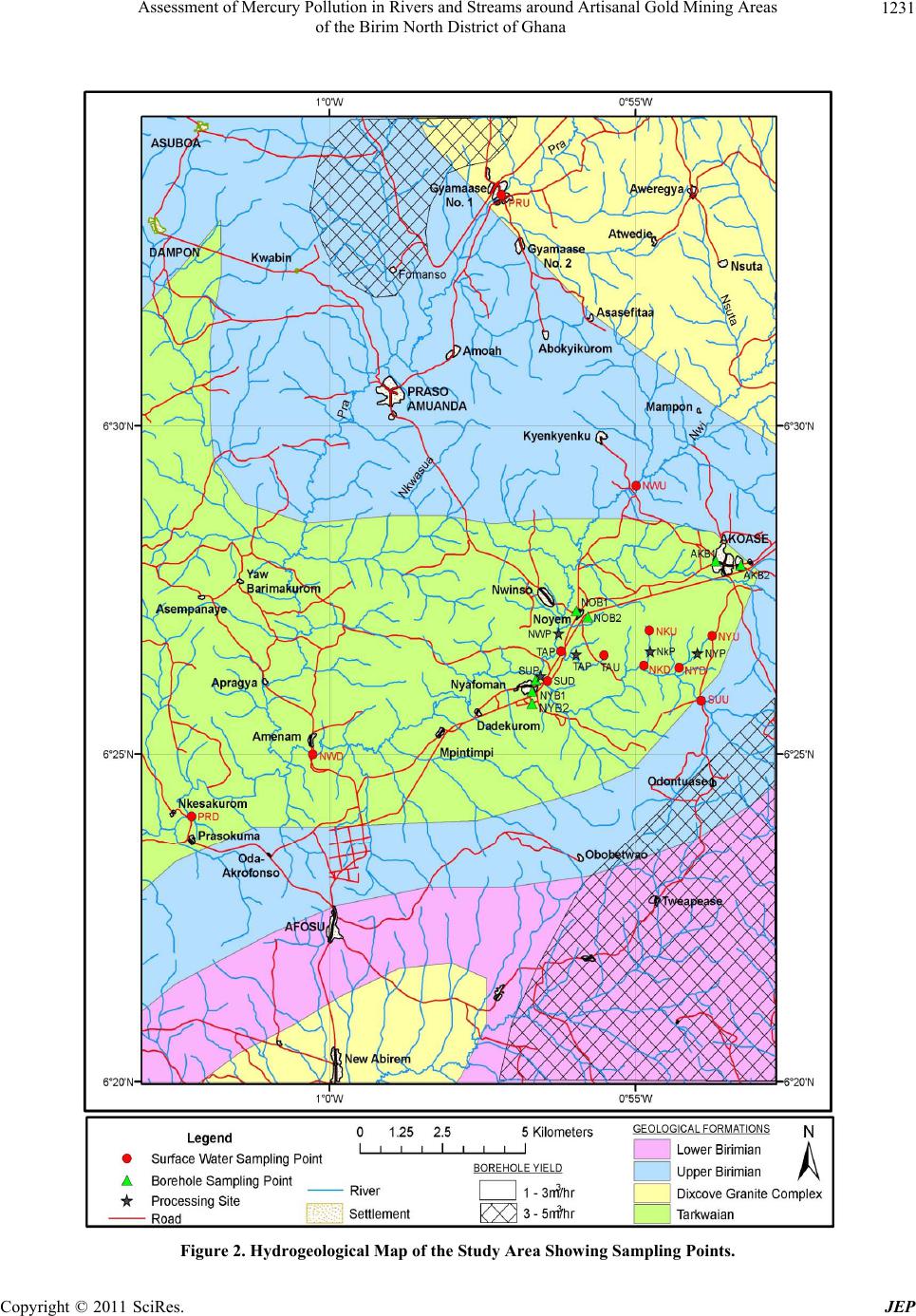 Assessment of Mercury Pollution in Rivers and Streams around Artisanal Gold Mining Areas 1231 of the Birim North District of Ghana Figure 2. Hydrogeological Map of the Study Area Showing Sampling Points. Copyright © 2011 SciRes. JEP 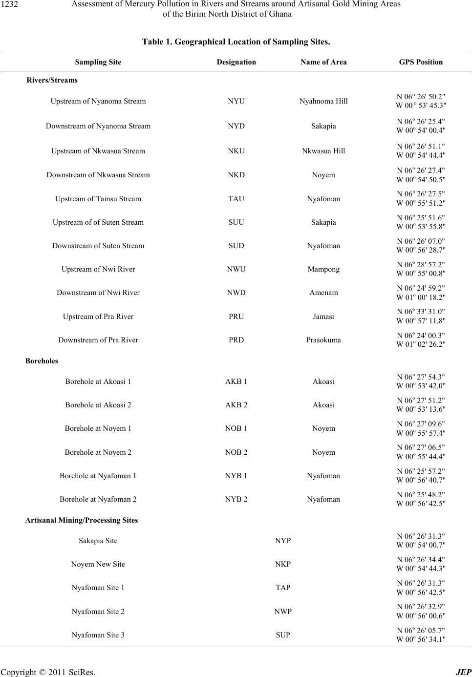 Assessment of Mercury Pollution in Rivers and Streams around Artisanal Gold Mining Areas 1232 of the Birim North District of Ghana Table 1. Geographical Location of Sampling Sites. Sampling Site Designation Name of Area GPS Position Rivers/Streams Upstream of Nyanoma Stream NYU Nyahnoma Hill N 06° 26' 50.2" W 00 o 53' 45.3" Downstream of Nyanoma Stream NYD Sakapia N 06o 26' 25.4" W 00o 54' 00.4" Upstream of Nkwasua Stream NKU Nkwasua Hill N 06o 26' 51.1" W 00o 54' 44.4" Downstream of Nkwasua Stream NKD Noyem N 06o 26' 27.4" W 00o 54' 50.5" Upstream of Tainsu Stream TAU Nyafoman N 06o 26' 27.5" W 00o 55' 51.2" Upstream of of Suten St ream SUU Sakapia N 06o 25' 51.6" W 00o 53' 55.8" Downstream of Suten Stream SUD Nyafoman N 0 6o 26' 07.0" W 00o 56' 28.7" Upstream of Nwi River NWU Mampong N 06o 28' 57.2" W 00o 55' 00.8" Downstream of Nwi River NWD Amenam N 06o 24' 59.2" W 01o 00' 18.2" Upstream of Pra River PRU Jamasi N 06o 33' 31.0" W 00o 57' 11.8" Downstream of Pra River PRD Prasokuma N 06o 24' 00.3" W 01o 02' 26.2" Boreholes Borehole at Akoasi 1 AKB 1 Akoasi N 06o 27' 54.3" W 00o 53' 42.0" Borehole at Akoasi 2 AKB 2 Akoasi N 06o 27' 51.2" W 00o 53' 13.6" Borehole at Noyem 1 NOB 1 Noyem N 06o 27' 09.6" W 00o 55' 57.4" Borehole at Noyem 2 NOB 2 Noyem N 06o 27' 06.5" W 00o 55' 44.4" Borehole at Nyafoman 1 NYB 1 Nyafoman N 06o 25' 57.2" W 00o 56' 40.7" Borehole at Nyafoman 2 NYB 2 Nyafoman N 06o 25' 48.2" W 00o 56' 42.5" Artisanal Mining/Processing Sites Sakapia Site NYP N 06o 26' 31.3" W 00o 54' 00.7" Noyem New Site NKP N 06o 26' 34.4" W 00o 54' 44.3" Nyafoman Site 1 TAP N 06o 26' 31.3" W 00o 56' 42.5" Nyafoman Site 2 NWP N 06o 26' 32.9" W 00o 56' 00.6" Nyafoman Site 3 SUP N 06o 26' 05.7" W 00o 56' 34.1" C opyright © 2011 SciRes. JEP 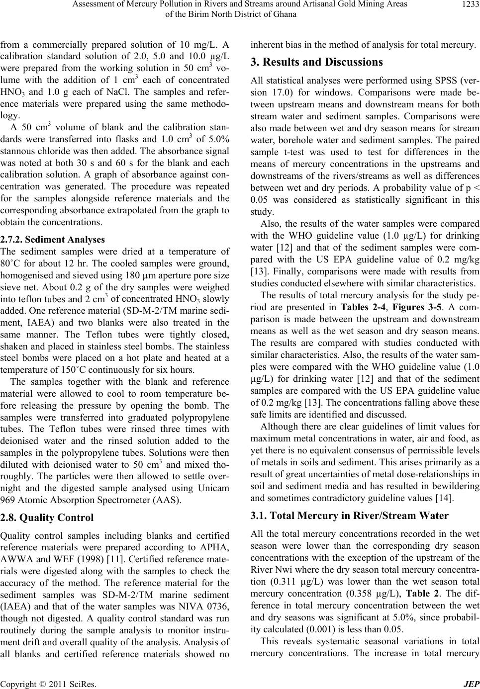 Assessment of Mercury Pollution in Rivers and Streams around Artisanal Gold Mining Areas of the Birim North District of Ghana Copyright © 2011 SciRes. JEP 1233 from a commercially prepared solution of 10 mg/L. A calibration standard solution of 2.0, 5.0 and 10.0 µg/L were prepared from the working solution in 50 cm3 vo- lume with the addition of 1 cm3 each of concentrated HNO3 and 1.0 g each of NaCl. The samples and refer- ence materials were prepared using the same methodo- logy. A 50 cm3 volume of blank and the calibration stan- dards were transferred into flasks and 1.0 cm3 of 5.0% stannou s chlorid e was then add ed. The ab sorban ce sign al was noted at both 30 s and 60 s for the blank and each calibration solution. A graph of absorbance against con- centration was generated. The procedure was repeated for the samples alongside reference materials and the corresponding absorbance extrapolated from the graph to obtain the concentrations. 2.7.2. Sediment Analyses The sediment samples were dried at a temperature of 80˚C for about 12 hr. The cooled samples were ground, homogenised and sieved using 180 µm aperture pore size sieve net. About 0.2 g of the dry samples were weighed into teflon tubes and 2 cm3 of concentrated HNO3 slowly added. One reference material (SD-M-2/TM marine sedi- ment, IAEA) and two blanks were also treated in the same manner. The Teflon tubes were tightly closed, shaken and placed in stainless steel bombs. The stainless steel bombs were placed on a hot plate and heated at a temperature of 150˚C continuously for six hours. The samples together with the blank and reference material were allowed to cool to room temperature be- fore releasing the pressure by opening the bomb. The samples were transferred into graduated polypropylene tubes. The Teflon tubes were rinsed three times with deionised water and the rinsed solution added to the samples in the polypropylene tubes. Solutions were then diluted with deionised water to 50 cm3 and mixed tho- roughly. The particles were then allowed to settle over- night and the digested sample analysed using Unicam 969 Atomic Absorption Spectrometer (AAS). 2.8. Quality Control Quality control samples including blanks and certified reference materials were prepared according to APHA, AWWA and WEF (1998) [11]. Certified reference mate- rials were digested along with the samples to check the accuracy of the method. The reference material for the sediment samples was SD-M-2/TM marine sediment (IAEA) and that of the water samples was NIVA 0736, though not digested. A quality control standard was run routinely during the sample analysis to monitor instru- ment drift and overall quality o f the analysis. Analysis of all blanks and certified reference materials showed no inherent bias in the method of analysis for total mercury. 3. Results and Discussions All statistical analyses were performed using SPSS (ver- sion 17.0) for windows. Comparisons were made be- tween upstream means and downstream means for both stream water and sediment samples. Comparisons were also made between wet and dry season means for stream water, borehole water and sediment samples. The paired sample t-test was used to test for differences in the means of mercury concentrations in the upstreams and downstreams of the rivers/streams as well as differences between wet and dry periods. A probability value of p < 0.05 was considered as statistically significant in this study. Also, the results of the water samples were compared with the WHO guideline value (1.0 µg/L) for drinking water [12] and that of the sediment samples were com- pared with the US EPA guideline value of 0.2 mg/kg [13]. Finally, comparisons were made with results from studies conducted elsewhere with similar characteristics. The results of total mercury analysis for the study pe- riod are presented in Tables 2-4, Figures 3-5. A com- parison is made between the upstream and downstream means as well as the wet season and dry season means. The results are compared with studies conducted with similar characteristics. Also, the results of the water sam- ples were compared with the WHO guideline value (1.0 µg/L) for drinking water [12] and that of the sediment samples are compared with the US EPA guideline value of 0.2 mg/kg [13]. Th e con c entration s falling abov e th ese safe limits are identified and discu ssed. Although there are clear guidelines of limit values for maximum metal concen trations in water, air and food, as yet there is no equivalent consensus of permissible levels of metals in soils and sediment. This arises primarily as a result of great uncertainties of metal dose-relatio nships in soil and sediment media and has resulted in bewildering and sometimes contradictory guideline values [14]. 3.1. Total Mercury in River/Stream Water All the total mercury concentrations recorded in the wet season were lower than the corresponding dry season concentrations with the exception of the upstream of the River Nwi where the dry season total mercury concentra- tion (0.311 µg/L) was lower than the wet season total mercury concentration (0.358 µg/L), Table 2. The dif- ference in total mercury concentration between the wet and dry seasons was significant at 5.0%, since probabil- ity calculated (0.001) is less than 0.05. This reveals systematic seasonal variations in total mercury concentrations. The increase in total mercury 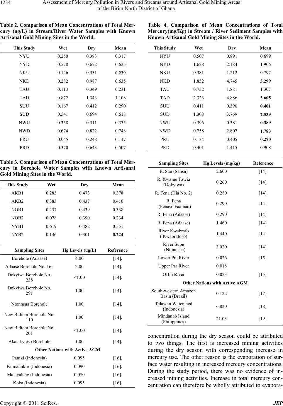 Assessment of Mercury Pollution in Rivers and Streams around Artisanal Gold Mining Areas 1234 of the Birim North District of Ghana Table 2. Comparison of Mean Concentrations of Total Mer- cury (µg/L) in Stream/River Water Samples with Known Artisanal Gold Mining Sites in the World . This Study Wet Dry Mean NYU 0.250 0.383 0.317 NYD 0.578 0.672 0.625 NKU 0.146 0.331 0.239 NKD 0.282 0.987 0.635 TAU 0.113 0.349 0.231 TAD 0.872 1.343 1.108 SUU 0.167 0.412 0.290 SUD 0.541 0.694 0.618 NWU 0.358 0.311 0.335 NWD 0.674 0.822 0.748 PRU 0.045 0.248 0.147 PRD 0.370 0.643 0.507 Table 3. Comparison of Mean Concentrations of Total Mer- cury in Borehole Water Samples with Known Artisanal Gold Mining Sites in the World. This Study Wet Dry Mean AKB1 0.283 0.473 0.378 AKB2 0.383 0.437 0.410 NOB1 0.237 0.439 0.338 NOB2 0.078 0.390 0.234 NYB1 0.619 0.482 0.551 NYB2 0.146 0.301 0.224 Sampling Sites Hg Levels (ug/L) Reference Borehole (Adaase) 4.00 [14]. Adaase Borehole No. 162 2.00 [14]. Dokyiwa Borehole No. 238 <1.00 [14]. Dokyiwa Borehole No. 291 1.00 [14]. Ntonnsua Borehol e 1.00 [14]. New Bidiem Borehole No. 110 1.00 [14]. New Bidiem Borehole No. 201 <1.00 [14]. Akatakyieso Borehole 1.00 [14]. Other Nations with Active AGM Paniki (Indonesia) 0.095 [16]. Kumahukur (Indonesia) 0.090 [16]. Malayalang (Indonesia) 0.070 [16]. Koka (Indonesia) 0.095 [16]. Table 4. Comparison of Mean Concentrations of Total Mercury(mg/Kg) in Stream / River Sediment Samples with Known Artisanal Gold Mining Sites in the World. This Study Wet Dry Mean NYU 0.507 0.891 0.699 NYD 1.628 2.184 1.906 NKU 0.381 1.212 0.797 NKD 1.852 4.745 3.299 TAU 0.732 1.881 1.307 TAD 2.323 4.886 3.605 SUU 0.411 0.390 0.401 SUD 1.308 3.769 2.539 NWU 0.396 0.381 0.389 NWD 0.758 2.807 1.783 PRU 0.134 0.405 0.270 PRD 0.401 1.415 0.908 Sampling Sites Hg Levels (mg/kg) Reference R. San (Sansu) 2.600 [14]. R. Kwame Tawia (Dokyiwa) 0.260 [14]. R. Fena (Hia No. 2) 0.280 [14]. R. Fena (Fenaso Faaman) 0.290 [14]. R. Fena (Adaase) 0.290 [14]. R. Fena (Adaase) 1.460 [14]. River Kwabrafo ( Kwabrafoso) 1.440 [14]. River Supu (Ntonnsua) 3.020 [14]. Lower Pra River 0.026 [15]. Upper Pra River 0.018 Offin River 0 .023 [15]. Other Nations with Active AGM South-western Amazon Basin (Brazil) 0.122 [17]. Talawan Watershed (Indonesia) 6.820 [18]. Mindanao Island (Philippines) 21.03 [19]. concentration during the dry season could be attributed to two things. The first is increased mining activities during the dry season with corresponding increase in mercury use. The other reason is the evaporation of sur- face water resulting in increased mercury concentrations. During the study period, there was no evidence of in- creased mining activities. Increase in total mercury con- centration can therefore be wholly attributed to evapora- C opyright © 2011 SciRes. JEP  Assessment of Mercury Pollution in Rivers and Streams around Artisanal Gold Mining Areas of the Birim North District of Ghana Copyright © 2011 SciRes. JEP 1235 0.0 0.2 0.4 0.6 0.8 1.0 1.2 1.4 1.6 NYU NYD NKU NKDTAUTADSUUSUD NWUNWD PRUPRD Sampling Points Total Mercury (ug/L) Wet Season Dry Seas on WHO Guide l i ne Figure 3. Total Mercury Analysis of Stream/River Water Samples (NYU) = Upstream of Nyanoma Stream, (NYD) = Down- stream of Nyanoma Stream, (NKU) = Upstream of Nkwasua Stream, (NKD) = Downstream of Nkwasua Stream, (TAU) = Upstream of Tainsu Stream, (TAD) = Downstream of Tainsu Stream, (SUU) = Upstream of Suten Stream, (SUD) = Down- stream of Suten Stream, (NWU) = Upstream of Nwi River, (NWD) = Downstream of Nwi River, (PRU) = Upstream of Pra River, (PRD) = Downstream of Pra River. 0.0 0.2 0.4 0.6 0.8 1.0 1.2 AKB1 AKB2 NOB1 NOB2 NYB1 NYB2 Sampling Points Total Mercury (ug/L) Wet Season Dry Season WHO Guideline Figure 4. Total Mercury Analysis of Borehole Water Samples (AKB1) = Borehole at Akoasi 1, (AKB2) = Borehole at Akoasi 2, (NOB1) = Borehole at Noyem 1, (NOB2) = Borehole at Noyem 2, (NYB1) = Borehole at Nyafoman 1, (NYB2) = Borehole at Nyafoman 2.  Assessment of Mercury Pollution in Rivers and Streams around Artisanal Gold Mining Areas 1236 of the Birim North District of Ghana 0.0 1.0 2.0 3.0 4.0 5.0 6.0 NYU NYD NKU NKDTAUTADSUUSUDNWUNWD PRUPRD Sampling Points Total Mercury (mg/kg) Wet Seas on Dry Seas on US-EPA Guideline Figure 5. Total Mercury Analysis of Stream/River Sediment Samples (NYU) = Upstream of Nyanoma Stream, (NYD) = Downstream of Nyanoma Stream, (NKU) = Upstream of Nkwasua Stream, (NKD) = Downstream of Nkwasua Stream, (TAU) = Upstream of Tainsu Stream, (TAD) = Downstream of Tainsu Stream, (SUU) = Upstream of Suten Stream,( SUD) = Down- stream of Suten Stream, (NWU) = Upstream of Nwi River, (NWD) = Downstream of Nwi River, (PRU) = Upstream of Pra River, (PRD) = Downstream of Pra River. tive effects. Also, during the dry season, river mixing is very minimal and this prevents mercur y in bottom layers of the rivers from coming to the surface to be volatilized. None of the wet season total mercury concentrations exceeded the WHO guideline value (1.0 µg/L) for drink- ing water [12]. Even though that of the downstream of Tainsu River (0.872 µg/L) was considerably close. The lowest total mercury concentration recorded during the dry season was 0.248µg/L in the River Pra. The total mercury concentrations were higher in all the downstreams of the rivers/streams than the correspond- ing upstream. The difference is significant at 5.0% since probability calculated (0.001) is less than 0.05. This su- ggests that the gold recovery activities contribute immen- sely to the level of mercury in these water bodies, result- ing in increased mercury concentrations downstream of each of the rivers/streams. None of the upstream total mercury concentrations exceeded the WHO guideline value (1.0 µg/L) for drink- ing water [12]. The lowest upstream total mercury con- centration of 0.045 µg/L was recorded in the Pra River during the rainy season whilst the highest (0.412 µg/L) was recorded in the River Suten during the dry season. The lowest downstream total mercury concentration of 0.282 µg/L was recorded in the Nkwasua River during the wet season and the highest (1.343 µg/L) which ex- ceeds the WHO guideline value (1.0 µg/L) for drinking water was recorded in River Tainsu during the dry sea- son. Other downstream total mercury concentrations which were significant but lower than the WHO guideline value (1.0 µg/L) for drinking water [12] included Nkwasua (0.987 µg/L) during the dry season, Tainsu (0.872 µg/L) during the wet season and Nwi (0.822 µg/L) during the dry season. In both the wet and dry seasons, trends in total mer- cury concentrations showed peak values at the down- stream of River Tainsu. This may be d ue to the proximity of a gold processing site to the downstream of the river. There were very significant variations in the total mer- cury concentrations among the downstream sampling po- ints (range = 0.282 – 1.343 µg/L) th an the upstream sam- pling points (rang e = 0.045 – 0.412 µg/L) indep endent of the sampling time. These variations were most likely the result of the intensity of processing activities that take place along the individual rivers. In comparing with other studies conducted in Ghana and other countries, the data available did not differenti- ate between wet and dry periods and therefore the com- parisons are made between the means only. Table 2 gives the comparative resu lts for water samples from the study area, other artisanal gold mining areas in Ghana with similar geology and three other known artisanal gold mining sites in the world. The Rivers Fena, Kwa- C opyright © 2011 SciRes. JEP  Assessment of Mercury Pollution in Rivers and Streams around Artisanal Gold Mining Areas 1237 of the Birim North District of Ghana brafo, Kwame Tawia, Supu, San, Buama and Jimi are all located in the Offin Sub-basin of the Pra Basin. The ri- vers in the Talawan watershed (Indonesia) include Lotta, Pancuran IX, ‘Sea’, Malalayang, Paal II, Perumnas and Kilu. The Mutum Parana, Prainha, Humaita, Porto Velho and Cachoreira Rivers are all located in the South-west- ern Amazon Basin where most gold mining activities in Brazil occur. A comparison of the data from this stud y with that ob- tained by others at the River Pra basin in previous studies revealed that all the total mercury concentrations repor- ted were relatively higher than those recorded at all the sampling points in this study [15,16]. The differences could be attributed to factors such as the length of time that gold processing has taken place in the rivers/streams, the period of sampling, the sample collection/handling procedures as well as analytical tools employed. The total mercury concentrations in the river/stream water samples collected from the study area were rela- tively higher than values recorded) at the Talawan Wa- tershed (Indonesia) [17]. Also , the total mercury concen- trations in the South-western Amazon Basin (Brazil) were relatively lower compared to the study area whereas that of the Philippines (Mindanao Island, 754.00 µg/L) far exceeds levels recorded in the study area. 3.2. Total Mercury in Borehole Water In wet and dry seasons, trends in total mercury concen- trations showed peak values at NYB1. This could be as a result of the proximity of NYB1 to the downstream of River Suten which also serves as a gold processing site. The mean mercury values for both seasons were 0.291 µg/L (wet) and 0.420 µg/L (dry). The total mercury con- centrations measured in the wet season were lower than the corresponding dry season concentrations with the exception of NYB1 where the wet season total mercury concentration (0.619 µg/L) was higher than the dry sea- son total mercury concentration (0.482 µg/L). NYB1 recorded the highest dry season total mercury concentra- tion of 0.482 µg/L whilst the lowest of 0.301 µg/L was recorded at NYB2. The lowest wet season total mercury concentration of 0.078 µg/L was measured at NOB2 and the highest 0.619 µg/L at NYB1. The difference in total mercury concentrations between the two seasons was insignificant at 5.0%, since probability calculated (0.096) is greater than 0.05. None of the total mercury concentrations exceeded the WHO guideline value (1.0 µg/L) for drink ing water [12]. Measured total mercury concentrations in this study ranged from 0.078 µg/L to 0.619 µg/L in the wet season and from 0.301 µg/L to 0.482 µg/L in the dry season. This shows that there are variations among the various sampling sites in the total mercury concentrations meas- ured in the wet season more than those measured in the dry season. Table 3 gives the comparative results for borehole water samples from the study area, other mining areas in Ghana and artisanal gold mining sites located in the Ta- lawan watersh e d of Ind o nesia. A comparison of the data from this stud y with that ob- tained in a study at Obuasi and its surrounding commu- nities show that all the total mercury concentrations re- ported were relatively higher than that recorded at all the sampling points in this study [15]. The differences could be attributed to factors such as the depth of the boreholes, soil type, proximity to gold processing sites as well as the length of time that gold mining has taken place in the areas. The mean total mercury concentrations in the borehole water samples collected from the study area were also relatively higher than all the known sites in In- donesia. 3.3. Total Mercury in River/Stream Sediments Sediments represent an important component of aquatic ecosystems because of the niche and food source they provide for benthic aquatic organisms. The protection of sediment quality is therefore viewed as a logical and needed extension of water quality protection. All the total mercury concentrations measured in the dry season were higher than the corresponding wet season concen- trations with the exception of the upstream of Rivers Nwi and Suten, Table 4. In the case of the upstream of River Nwi, the wet season total mercury concentration was 0.396 mg/kg an d the dry season total mercury con centra- tion was 0.381 mg/kg. Also, the wet season total mercury concentration of the upstream of River Suten was 0.411 mg/kg whereas the dry season concentration was 0.390 mg/kg. The difference in total mercury concentration between the wet and dry seasons was significant at 5.0% since probability calculated (0.003) is less than 0.05. Two reasons may have contributed to this seasonal variation in total mercury concentration. The first is in- creased mining activities during the dry season with cor- responding increase in mercury use. The other reason is the evaporation of surface water resulting in increased mercury concentrations in the water and sediments. Dur- ing the study period, there was no evidence of increased mining activities. In crease in total mercury concentration can therefore be wholly attributed to evaporative effects. Also, during the dry season, river mixing is very minimal and this prevents mercury in bottom layers of the sedi- ments from coming to the surface to be volatilized. The total mercury concentration s of the upstreams and downstreams of all the rivers/streams during both the wet Copyright © 2011 SciRes. JEP  Assessment of Mercury Pollution in Rivers and Streams around Artisanal Gold Mining Areas 1238 of the Birim North District of Ghana and dry seasons exceeded the US EPA guideline value of 0.2 mg/kg with the exception of the upstream of the Pra River (0.134 mg/kg) during the wet season. The total mercury concentrations were lower in all the upstreams of the rivers/streams than the corresponding downstreams. The difference is significant at 5.0% since probability calculated (0.001) is less than 0.05. This may be as a result of the dumping of contaminated tailings and waste water into the water bodies, resulting in increased mer- cury concentrations in the sediments downstream of each of the rivers/streams. The highest upstream total mercury concentration of 1.881 mg/kg was recorded in the Tainsu stream during the dry season whilst the lowest (0.134 mg/kg) was re- corded in the Pra River during the rainy season. The highest downstream total mercury con centratio n of 4.886 mg/kg was recorded in the Tainsu stream during the dry season and the lowest (0 .401 mg/kg) was recorded in the Pra River during the wet season. Other downstream total mercury concentrations which were very significant in- clude Nkwasua (4.745 mg/kg) and Suten (3.769 mg/kg) during the dry season. In both the wet and dry seasons, trends in total mer- cury concentrations showed peak values at the down- stream of Tainsu and Nkwasua streams, Figure 5. This could be attributed to the fact that the downstream of both streams are very close to gold processing sites. There were very significant variations in the total mercury con- centrations among the downstream sampling points (range = 0.401 - 4.886 mg/kg) more than the upstream sampling points (range = 0.134 - 1.881 mg/kg) indepen- dent of the sampling time. The differences in intensity of processing activities that take place along the individual rivers may have accounted for this. Generally, metals in sediments do not have immediate implications for human health as long as humans do not consume these sediments directly, but they can have se- rious consequences when they enter the food chain. Ta- ble 4 gives the comparative results for sediment samples from the study area, other mining areas in Ghana with similar geology and three other known artisanal gold mining sites located in Brazil, Indonesia and Philipp ines. A comparison of the data from this stud y with another on the Upper and Lower Pra [16]. revealed that the total mercury concentrations measured at all sampling points in this study exceeded the concentrations in the Upper Pra (0.018 mg/kg), the Lowe r Pra (0.026 mg/kg) and the Offin (0.023 mg/kg) Rivers. Another comparison with a study showed differential variation among the total mer- cury concentrations [15]. The difference could probably be due to differences in the length of time that gold pro- cessing has taken place in the rivers/streams, sediment grain size, organic matter content, sampling seasons, the sample collection/handling procedures as well as analy- tical tools employed. Compared with other active AGM sites in the world, the mean mercury values obtained in the study sediments were higher than that of Brazil, but lower than that of the Philippines and Indonesia. 4. Acknowledgements Our sincere thanks go to Mr. Felix Okyere Amoah of Land-tech Engineering Ltd. for helping pick all the GPS coordinates and also Mr. H. Komladzei of the Map Room of the Water Research Institute fo r drawing all the maps in this work. W e also appreciate the role played by Messrs Michael Dzorleku and Michael Afram Danquah of the Environmental Chemistry Laboratory of the W ater Research Institute in the analyses. The role played by the field assistants Messrs Agyarko Ayeh Asiedu and Daniel Asomani is acknowledged REFERENCES [1] O. Bermudez-Lugo, “Gold Fields Mineral Survey,” In: Ghana Chamber of Mines Factoid 2008, Ghana Chamber of Mines, Accra, 2008. [2] B. K. Ntibery, E. Atorkui and B. N. A. Aryee, “Trends in Small-Scale Mining of Precious Minerals in Ghana: A Perspective on its Environmental Impact,” Journal of Cleaner Produc tion, Vol. 11, 2003, pp. 131-140. doi:10.1016/S0959-6526(02)00043-4 [3] G. Hilson, “A Contextual Review of the Ghanaian Small-Scale Mining Industry,” Mining, Minerals and Sustainable Development (MMSD), Vol. 76, 2001, pp. 2-30. [4] J. Heintz, “Employment, Poverty and Gender in Ghana,” Political Economy Research Institute, University of Massachusetts, Amherst, Working Paper Series No. 92, 2005. [5] E. H. Mcdonald, “Alluvial Mining: The Geology, Tech- nology and Economics of Placers,” Chapman and Hall, London, 1983, p. 508. [6] K. H. Telmer and M. M. Veiga, “World Emissions of Mercury from Artisanal and Small Scale Gold Mining,” In: Mercury Fate and Transport in the Global Atmos- phere: Measurements, Models and Policy Implications, Interim Report of the UNEP Global Mercury Partnership, Mercury Transport and Fate Research Partnership Area, Accessed on 14 July 2008. http://www.cs.iia.cnr.it/UNEP-MFTP/index.htm [7] Birim North District Assembly, “Birim North District Profile,” An Unpublished Document, 2006. [8] G. O. Kesse, “The Mineral and Rock Resources of Ghana,” A. A. Balkema Publisher, Rotterdam, 1985. [9] J. S. Kuma, “Is Groundwater in the Tarkwa Gold Mining C opyright © 2011 SciRes. JEP  Assessment of Mercury Pollution in Rivers and Streams around Artisanal Gold Mining Areas of the Birim North District of Ghana Copyright © 2011 SciRes. JEP 1239 District of Ghana Potable?” Environmental Geology, Vol. 45, No. 3, 2004, pp. 391-400. doi:10.1007/s00254-003-0888-9 [10] Anonym, “Preventive Measures against Environmental Mercury Pollution and Its Health Effects,” Japan Public Health Association, 2001. [11] APHA, AWWA & WEF, “Standard Methods for the Examination of Water and Wastewater,” 20th Edition, Washington D.C., 1998. [12] WHO, “Guidelines for Drinking—Water Quality,” 4th Edition, World Health Organization, Geneva, Switzerland. 2006. [13] E. R. Long, D. D. MacDonalds, S. L Smith and F. D Cal- der, “Incidence of Adverse Biological Effects within Ranges of Chemical Concentrations in Marine and Estua- rine Sediments,” Environmental Management, Vol. 19, No. 1, 1995, pp. 81-97. Accessed on line 4 April 2010. http://water.epa.gov./polwaste/sediments/guidelines.cfm [14] M. Macklin, “Metal Contaminated Soils and Sediment: A Geographical Perspective,” In: M. Newson, Ed., Manag- ing the Human Impact on the Natural Environmental Patterns and Processes, Belhaven Press, London, 1992, pp. 173-193. [15] T. M. Akabzaa, J. S. Seyire and K. Afriyie, “The Glitter- ing Façade: Effects of Mining Activities on Obuasi and its Surrounding Communities,” Third World Network— Africa, 2007. [16] A. K. Donkor, V. K. Nartey, J. C. Bonzongo and D. K. Adotey, “Artisanal Mining of Gold with Mercury in Ghana,” West Africa Journal of Applied Ecology, Vol. 9, 2006, 8 Pages. [17] D. Limbong, J. Kumampung, I. F. M. Rumengan, T. Arai and N. Miyazaki, “Measurement of Total Mercury Con- centration in the Water Source Pool of Public Drink Wa- ter Installations around Manado City, North Sulawesi, Indonesia. Otsuchi,” Marine Science, Vol. 28, 2003, pp. 99-101. [18] C. Aspinall, “Small-Scale Mining in Indonesia,” Mining, Minerals and Sustainable Development (MMSD), Vol. 79, 2001, pp. 2-30. [19] G. Drasch, S. Böse-O’Reilly, C. Beinhoff, G. Roider and S. Maydl, “The Mt. Diwata Study on the Philippines 1999—Assessing Mercury Intoxication of the Population by Small-Scale Gold Mining,” The Science of the Total Environment, Vol. 267, 2001, pp. 151-168. doi:10.1016/S0048-9697(00)00806-8
|