R. SHOFIYATI ET AL.
Copyright © 2011 SciRes. JGIS
355
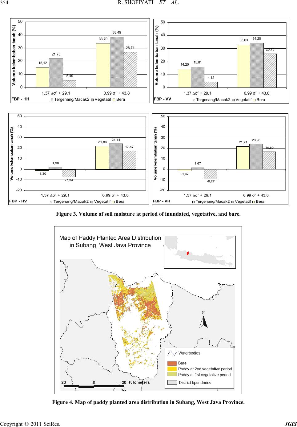
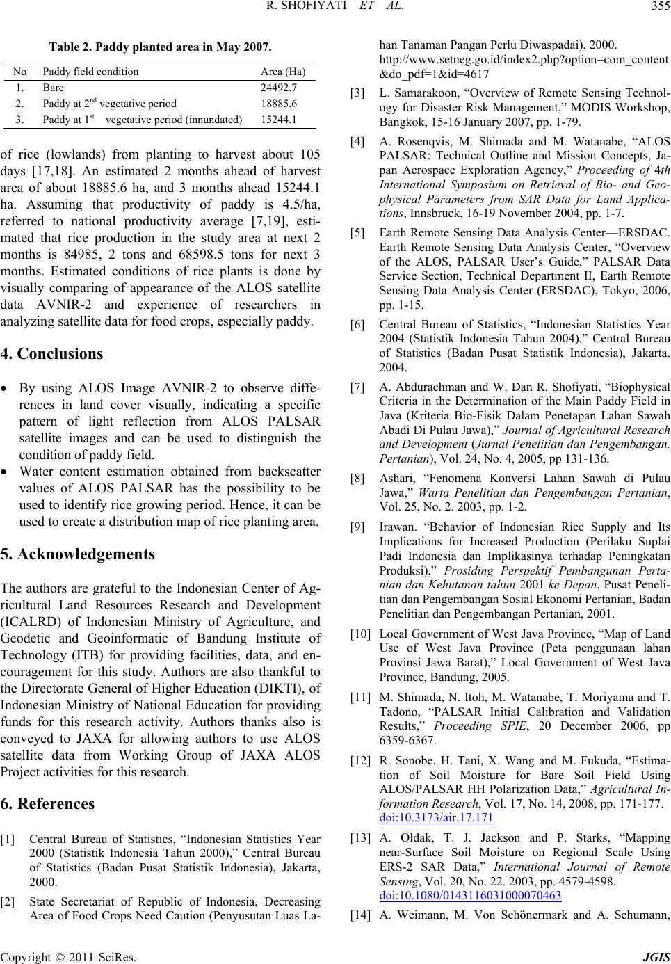
Table 2. Paddy planted area in May 2007.
No Paddy field condition Area (Ha)
1. Bare 24492.7
2. Paddy at 2nd vegetative period 18885.6
3. Paddy at 1st vegetative period (innundated) 15244.1
of rice (lowlands) from planting to harvest about 105
days [17,18]. An estimated 2 months ahead of harvest
area of about 18885.6 ha, and 3 months ahead 15244.1
ha. Assuming that productivity of paddy is 4.5/ha,
referred to national productivity average [7,19], esti-
mated that rice production in the study area at next 2
months is 84985, 2 tons and 68598.5 tons for next 3
months. Estimated conditions of rice plants is done by
visually comparing of appearance of the ALOS satellite
data AVNIR-2 and experience of researchers in
analyzing satellite data for food crops, especially paddy.
4. Conclusions
By using ALOS Image AVNIR-2 to observe diffe-
rences in land cover visually, indicating a specific
pattern of light reflection from ALOS PALSAR
satellite images and can be used to distinguish the
condition of paddy field.
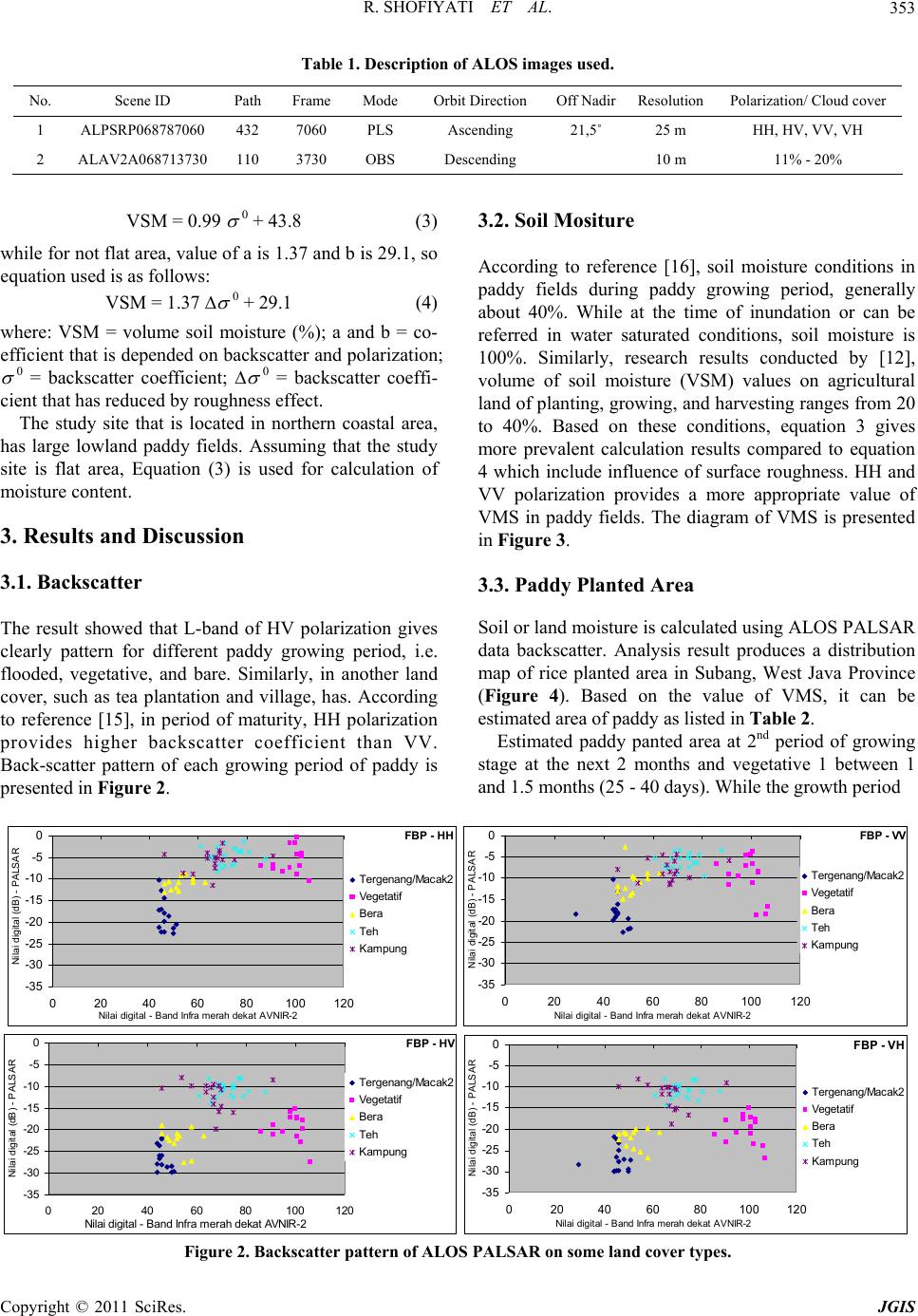
Water content estimation obtained from backscatter
values of ALOS PALSAR has the possibility to be
used to identify rice growing period. Hence, it can be
used to create a distribution map of rice planting area.
5. Acknowledgements
The authors are grateful to the Indonesian Center of Ag-
ricultural Land Resources Research and Development
(ICALRD) of Indonesian Ministry of Agriculture, and
Geodetic and Geoinformatic of Bandung Institute of
Technology (ITB) for providing facilities, data, and en-
couragement for this study. Authors are also thankful to
the Directorate General of Higher Education (DIKTI), of
Indonesian Ministry of National Education for providing
funds for this research activity. Authors thanks also is
conveyed to JAXA for allowing authors to use ALOS
satellite data from Working Group of JAXA ALOS
Project activities for this research.
6. References
[1] Central Bureau of Statistics, “Indonesian Statistics Year
2000 (Statistik Indonesia Tahun 2000),” Central Bureau
of Statistics (Badan Pusat Statistik Indonesia), Jakarta,
2000.
[2] State Secretariat of Republic of Indonesia, Decreasing
Area of Food Crops Need Caution (Penyusutan Luas La-
han Tanaman Pangan Perlu Diwaspadai), 2000.
http://www.setneg.go.id/index2.php? option= com_content
&do_pdf=1&id=4617
[3] L. Samarakoon, “Overview of Remote Sensing Technol-
ogy for Disaster Risk Management,” MODIS Workshop,
Bangkok, 15-16 January 2007, pp. 1-79.
[4] A. Rosenqvis, M. Shimada and M. Watanabe, “ALOS
PALSAR: Technical Outline and Mission Concepts, Ja-
pan Aerospace Exploration Agency,” Proceeding of 4th
International Symposium on Retrieval of Bio- and Geo-
physical Parameters from SAR Data for Land Applica-
tions, Innsbruck, 16-19 November 2004, pp. 1-7.
[5] Earth Remote Sensing Data Analysis Center—ERSDAC.
Earth Remote Sensing Data Analysis Center, “Overview
of the ALOS, PALSAR User’s Guide,” PALSAR Data
Service Section, Technical Department II, Earth Remote
Sensing Data Analysis Center (ERSDAC), Tokyo, 2006,
pp. 1-15.
[6] Central Bureau of Statistics, “Indonesian Statistics Year
2004 (Statistik Indonesia Tahun 2004),” Central Bureau
of Statistics (Badan Pusat Statistik Indonesia), Jakarta.
2004.
[7] A. Abdurachman and W. Dan R. Shofiyati, “Biophysical
Criteria in the Determination of the Main Paddy Field in
Java (Kriteria Bio-Fisik Dalam Penetapan Lahan Sawah
Abadi Di Pulau Jawa),” Journal of Agricultural Research
and Development (Jurnal Penelitian dan Pengembangan.
Pertanian), Vol. 24, No. 4, 2005, pp 131-136.
[8] Ashari, “Fenomena Konversi Lahan Sawah di Pulau
Jawa,” Warta Penelitian dan Pengembangan Pertanian,
Vol. 25, No. 2. 2003, pp. 1-2.
[9] Irawan. “Behavior of Indonesian Rice Supply and Its
Implications for Increased Production (Perilaku Suplai
Padi Indonesia dan Implikasinya terhadap Peningkatan
Produksi),” Prosiding Perspektif Pembangunan Perta-
nian dan Kehutanan tahun 2001 ke Depan, Pusat Peneli-
tian dan Pengembangan Sosial Ekonomi Pertanian, Badan
Penelitian dan Pengembangan Pertanian, 2001.
[10] Local Government of West Java Province, “Map of Land
Use of West Java Province (Peta penggunaan lahan
Provinsi Jawa Barat),” Local Government of West Java
Province, Bandung, 2005.
[11] M. Shimada, N. Itoh, M. Watanabe, T. Moriyama and T.
Tadono, “PALSAR Initial Calibration and Validation
Results,” Proceeding SPIE, 20 December 2006, pp
6359-6367.
[12] R. Sonobe, H. Tani, X. Wang and M. Fukuda, “Estima-
tion of Soil Moisture for Bare Soil Field Using
ALOS/PALSAR HH Polarization Data,” Agricultural In-
formation Research, Vol. 17, No. 14, 2008, pp. 171-177.
doi:10.3173/air.17.171
[13] A. Oldak, T. J. Jackson and P. Starks, “Mapping
near-Surface Soil Moisture on Regional Scale Using
ERS-2 SAR Data,” International Journal of Remote
Sensing, Vol. 20, No. 22. 2003, pp. 4579-4598.
doi:10.1080/0143116031000070463
[14] A. Weimann, M. Von Schönermark and A. Schumann,