A. R. J. RAD ET AL.
Copyright © 2011 SciRes. JGIS
317
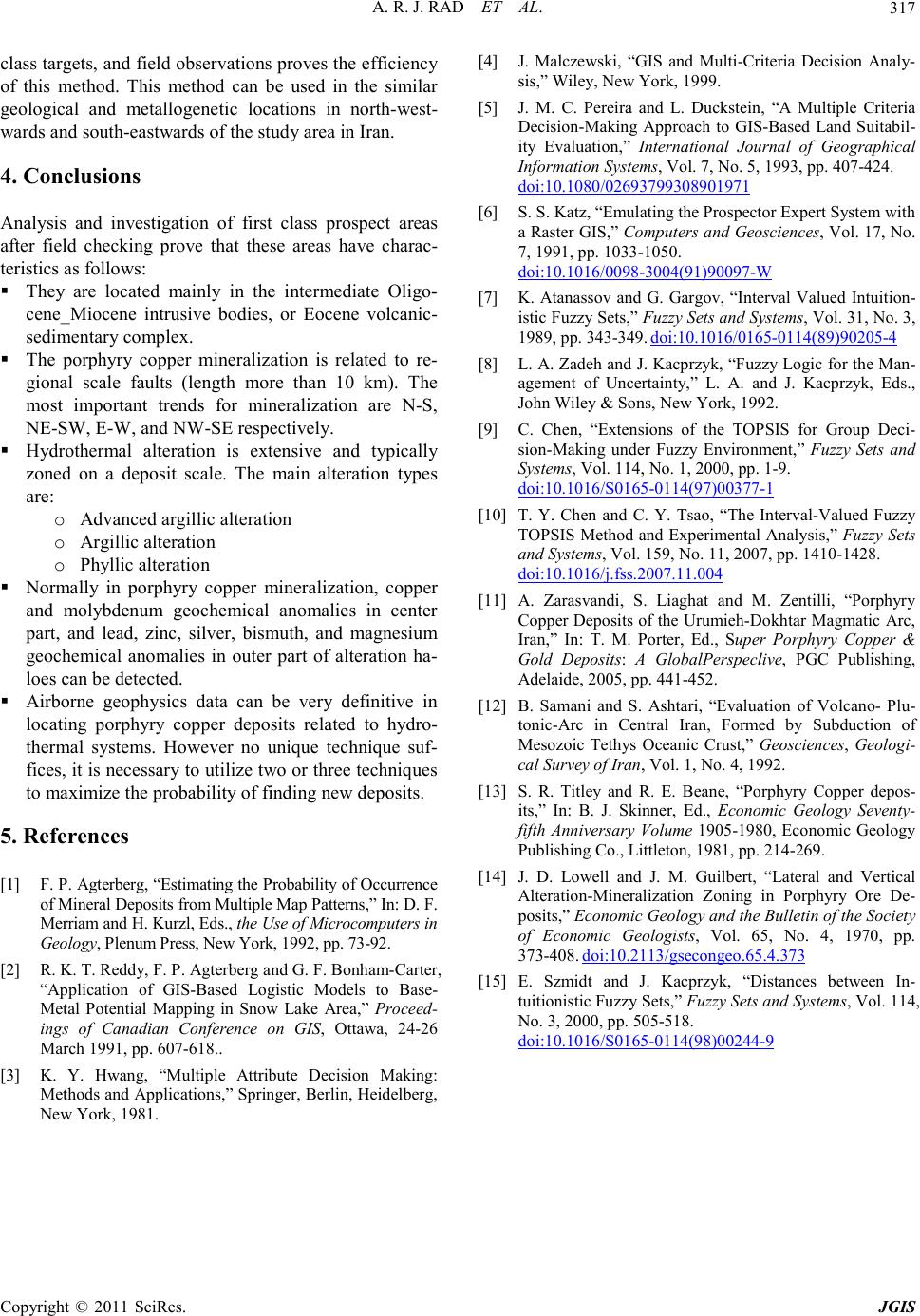
class targets, and field observations proves the efficiency
of this method. This method can be used in the similar
geological and metallogenetic locations in north-west-
wards and south-eastward s of the study area in Iran.
4. Conclusions
Analysis and investigation of first class prospect areas
after field checking prove that these areas have charac-
teristics as follows:
They are located mainly in the intermediate Oligo-
cene_Miocene intrusive bodies, or Eocene volcanic-
sedimentary complex.
The porphyry copper mineralization is related to re-
gional scale faults (length more than 10 km). The
most important trends for mineralization are N-S,
NE-SW, E-W, and NW-SE respectively.
Hydrothermal alteration is extensive and typically
zoned on a deposit scale. The main alteration types
are:
o Advanced argillic alteration
o Argillic alteration
o Phyllic alteration
Normally in porphyry copper mineralization, copper
and molybdenum geochemical anomalies in center
part, and lead, zinc, silver, bismuth, and magnesium
geochemical anomalies in outer part of alteration ha-
loes can be detected.
Airborne geophysics data can be very definitive in
locating porphyry copper deposits related to hydro-
thermal systems. However no unique technique suf-
fices, it is necessary to utilize two or three techniques
to maximize the probability of finding new deposits.
5. References
[1] F. P. Agterberg, “Estimating the Probability of Occurrence
of Mineral Deposits from Multiple Map Patterns,” In: D. F.
Merriam and H. Kurzl, Ed s., the Use of Microcomputers in
Geology, Plenum Pres s, New York, 1992, p p. 73- 92.
[2] R. K. T. Reddy, F. P. Agterberg and G. F. Bonham-Carter,
“Application of GIS-Based Logistic Models to Base-
Metal Potential Mapping in Snow Lake Area,” Proceed-
ings of Canadian Conference on GIS, Ottawa, 24-26
March 1991, pp. 607-618..
[3] K. Y. Hwang, “Multiple Attribute Decision Making:
Methods and Applications,” Springer, Berlin, Heidelberg,
New York, 1981.
[4] J. Malczewski, “GIS and Multi-Criteria Decision Analy-
sis,” Wiley, New York, 1999.
[5] J. M. C. Pereira and L. Duckstein, “A Multiple Criteria
Decision-Making Approach to GIS-Based Land Suitabil-
ity Evaluation,” International Journal of Geographical
Information Systems, Vol. 7, No. 5, 1993, pp. 407-424.
doi:10.1080/02693799308901971
[6] S. S. Katz, “Emulating the Prospector Expert System with
a Raster GIS,” Computers and Geosciences, Vol. 17, No.
7, 1991, pp. 1033-1050.
do i :10.1016/ 0098- 3004( 91)90 097-W
[7] K. Atanassov and G. Gargov, “Interval Valued Intuition-
istic Fuzzy Sets,” Fuzzy Sets and Systems, Vol. 31, No. 3,
1989, pp . 343-349. doi:10.1016/0165-0114(89)90205-4
[8] L. A. Zadeh and J. Kacprzyk, “Fuzzy Logic for the Man-
agement of Uncertainty,” L. A. and J. Kacprzyk, Eds.,
John Wiley & Sons, New York, 1992.
[9] C. Chen, “Extensions of the TOPSIS for Group Deci-
sion-Making under Fuzzy Environment,” Fuzzy Sets and
Systems, Vol. 114, No. 1, 2000, pp. 1-9.
doi:10.1016/S0165-0114(97)00377-1
[10] T. Y. Chen and C. Y. Tsao, “The Interval-Valued Fuzzy
TOPSIS Method and Experimental Analysis,” Fuzzy Sets
and Systems, Vol. 159, No. 11, 2007, pp. 1410-1428.
doi:10.1016/j.fss.2007.11.004
[11] A. Zarasvandi, S. Liaghat and M. Zentilli, “Porphyry
Copper Deposits of the Urumieh-Dokhtar Magmatic Arc,
Iran,” In: T. M. Porter, Ed., Super Porphyry Copper &
Gold Deposits: A GlobalPerspeclive, PGC Publishing,
Adelaide, 2005, pp. 441-452.
[12] B. Samani and S. Ashtari, “Evaluation of Volcano- Plu-
tonic-Arc in Central Iran, Formed by Subduction of
Mesozoic Tethys Oceanic Crust,” Geosci ences, Geologi-
cal Su rvey of Iran , Vol. 1, No. 4, 1992.
[13] S. R. Titley and R. E. Beane, “Porphyry Copper depos-
its,” In: B. J. Skinner, Ed., Economic Geology Seventy-
fifth Anniversary Volume 1905-1980, Economic Geology
Publishing Co., Littleton, 1981, pp. 214-269.
[14] J. D. Lowell and J. M. Guilbert, “Lateral and Vertical
Alteration-Mineralization Zoning in Porphyry Ore De-
posits,” Economic Geology and the Bulletin of the Society
of Economic Geologists, Vol. 65, No. 4, 1970, pp.
373-408. doi:10.2113/gsecongeo.65.4.373
[15] E. Szmidt and J. Kacprzyk, “Distances between In-
tuitionistic Fuzzy Sets,” Fuzzy Sets and Systems, Vol. 114,
No. 3, 2000, pp. 505-518.
doi:10.1016/S0165-0114(98)00244-9