Open Journal of Geology
Vol. 3 No. 3 (2013) , Article ID: 34319 , 11 pages DOI:10.4236/ojg.2013.33026
Tethys Subduction History in Caucasus Region
Department of Geology, Science and Research Breanch, Islamic Azad University, Tehran, Iran
Email: mmf_sg@yahoo.com
Copyright © 2013 Mojtaba Manafi et al. This is an open access article distributed under the Creative Commons Attribution License, which permits unrestricted use, distribution, and reproduction in any medium, provided the original work is properly cited.
Received March 25, 2013; revised April 25, 2013; accepted May 20, 2013
Keywords: Moghan; Tethys; Caucasus; Subduction; Gondwana; Baltic
ABSTRACT
Caucasus region is located in the center of Alpine-Himalayan orogenic belt. It is made of two Great and Lesser Caucasus fold thrust belts and an intramountain area called Trans caucasus or Mid caucasus. This region contains a system of oceanic crust subduction, island arcs, volcanic arcs, back arc basins and rifts. The earthquakes of 60 km in depth are the evidences of deep brittle zone under Great Caucasus. Without considering Prototethys, Paleotethys and Neotethys Oceans, the tectonic situation of this region is not possible to study. The oceanic lithosphere under oceanic lithosphere subduction made Trans caucasus containing a trans crust. The subduction of Prototethys under Baltic made Great Caucasus and the subduction of Paleotethys under Iran, made Lesser Caucasus. The earth sutures caused by the closure of Prototethys and Paleotethys Oceans are clear in the region. The direction of Paleotethys subduction in lesser Caucasus is a considerable issue. Most of the existing evidences prove the southward direction which is different from Paleotethys subduction in Alborz of Iran. The lithospheric type of Midcaucasus is different from Caspian. Midcaucasus plays the role of determining collision type in the region.
1. Introduction
According to lots of authors, Middle East region contains 10 unites: 1) Helmend and Farah in Afghanistan; 2) Southwest Pakistan and southeast Turkmenistan; 3) Alborz; 4) Central Iran; 5) Sanandaj-Sirjan; 6) Northwest Iran (probably up to east of turkey); 7) Pontides (Turkey); 8) Taurides (Turkey); 9) Great Caucasus; 10) Lesser Caucasus. Lesser and Great Caucasus are located between Caspian Sea and Black Sea. They contain Armenia, Azerbaijan, Georgia, southwest Russia and northwest of Iran. With a high probability, the studies show that all ten terranes are separated from each other. Middle East is an obvious sample of mosaic tectonic. Most of these terranes are highly deformed and are involved in a wide tectonic belt between Eurasia, Arabia and India. Northwest of Iran, east of turkey, Armenia, Azerbaijan and around have different structural units related to their middle east tectonic. The classification scale does not let to study these smaller units. Midcaucasus is one of the unites studied in this article. Moreover, by combining the new and old information, we tried to make an almost complete history of Caucasus tectonic.
In the other hand, according to some of the authors, in Iranian geological classifications the northwest part of this country is considered as a part of central Iran and according others is considered as a part of Alborz.
The tectonically differences between Gharedagh and Moghan with other parts of Iran, made us to study the history of Caucasus which later can be used in reclassification of structural unites of this country. Also, according to some of the researchers believing Caspian oceanic lithosphere and Black Sea are trapped, more study on Midcaucasus is required since it seems to have an important effect on lithospheres trapping.
2. Three Tethys Oceans
The structure interpretation of Caucasus is impossible without Tethys Oceans. Therefore, Tethys and the related expressions are going to be described in advance. According to geology, Paleobiography and paleomagnetism information, great longtime horizontal displacements occurred on Caucasus terranes before they could join to each other in a fold-thrust belt in Tethys Ocean [1-3].
During Paleozoic, the seaway developed in North of Middle East is called Paleotethys by some of the authors [4,5]. Some others called Prototethys Ocean (or Asian Ocean). The oceans in which Middle Silurian was created in the edges of Hun super terranes are called Prototethys [6-10]. The oceans created between Africa-Arabia (Gondwana) in middle Permian-Triassic called Neotethys by most of the authors [8], Mezotethys [11], Pindose Ocean [12]. Ruban et al. [13] used Prototethys for earlyPaleozoic Oceans while late-Paleozoic Oceans are called Paleotethys and Neotethys by them. Adamia et al. [14] used Prototethys Ocean for late Proterozoic, Paleotethys for late Proterozoic-early Paleozoic and Neotethys for Triassic-Jurassic.
In this study, the great ocean located between Baltic and Arabia-Africa is named Prototethys (the ocean between Great Caucasus and Trans Caucasus), Paleotethys is used for the ocean between Africa-Arabia and Trans Caucasus (the ocean between Trans Caucasus and Lesser Caucasus) and recent ocean located in Zagros-Bitlis is named Neotethys.
3. Caucasus Classification
Caucasus is located between the still converging Eurasian and African-Arabian lithospheric plates in the center of Alp-Himalayas orogenic belt. In late Proterozoic-early Cenozoic, this region belonged to Tethys Ocean and Eurasian and African-Arabian margins. Island arcs, active and passive continental margins and rifts existed in this region. Regarding crust type, we divide Caucasus into three blocks or terranes from north to south called Great Caucasus, Trans Caucasus and Lesser Caucasus (Figure 1). The common trend of Great Caucasus and Trans Caucasus is northwest-southeast, while it is approximately east-west for Lesser Caucasus in western part
(near Black Sea) and it follows northwest-southeast direction in the central and eastern part. Golonka. [12] considered Trans Caucasus as a distinct unit. Rustamov [15] considered Trans Caucasus massif and south Caspian as a tectonic unit. Ruban et al. [13] considered Trans Caucasus as a part of Great Caucasus, and Adamia et al. [14] considered Trans Caucasus and Great Caucasus as a unique unit called North Caucasus.
4. Late Precambrian
According to Adamia et al. [14], before construction of Great Caucasus and Lesser Caucasus in late Proterozoicearly Paleozoic, there was a mass with undistinguished crust type called Trans Caucasus. Aiming to reach to depth of 15,000 meter, the Russian Science Academy designed an ultra deep well in Saatlee region, where Aras and Kura rivers get connected. Reaching to the depth of about 8000 meters, they could gain accurate information of underneath rocks. According to our classification, this well was located in Trans Caucasus. The results of petrochemical and geochemical studies of volcanics beside the distribution data of rare elements in these deposits showed that these volcanoes similar with island arcs, had been originated from Calsic-Alkaline magmas [16]. The Trans Caucasus basement rocks belong to Late Proterozoic-Early Paleozoic. The studies of igneous masses in Trans Caucasus gave them the characteristics of island arcs [14]. Saatlee well contained some kilometers of
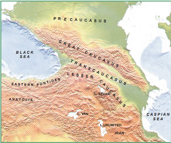
Figure 1. Physical map of the Caucasus and adjacent areas of the Black Sea-Caspian Sea region [14].
Mesozoic sedimentary and showed a very important hiatus in sedimentation of late Cretaceous to Miocene [17]. They could distinguish some volcanic complexes in this region. One of them is the wide developed sedimentaryvolcanic series in 4784 meter with Basalt, Andesite, Dolerite and Diorite during early-middle Jurassic. Two others are the developing of these series in 390 meter during late Jurassic and in 320 meter during late cretaceous with Carbonate and Basalt.
For the creation of Trans Caucasus with old basement rocks, we suggest a subduction inside Prototethys Ocean and using Adamia et al. [14] studies, a south direction is assumed for the subduction (Figure 2). This subduction is the reason of the construction of island arcs which are considered as the initial core of Trans Caucasus. As a transferring crust, Trans Caucasus didn’t have a remarkable extension. According to petrochemical studies of Adamia et al. [14] the region was made of volcanic and plutonic rocks in late Paleozoic, which shows the characteristics of island arcs. Prototethys was separated into two north and south parts in this period. The melted oceanic crust of Prototethys sounds to have a rift step in southern part which was later the cause of Paleotethys construction. Paleotethys ocean had been opening between Trans Caucasus and Africa-Arabia from late Proterozoic up to early Paleozoic while Prototethys Ocean had been closing between Trans Caucasus and Baltic (Figure 3).
The subduction direction of Prototethys was two-sided in the beginning (under Trans Caucasus and under Baltic). Then, while the subduction direction was enhuncing to north it was diminishing to south (Figure 4). The main reason came from the density difference between three oceanic plate, Baltic continental plate and Trans Caucasus plate and oceanic plate. Except granitoid massifs penetration inside Trans Caucasus, there are no clear indications about south subduction among available data [14,12].
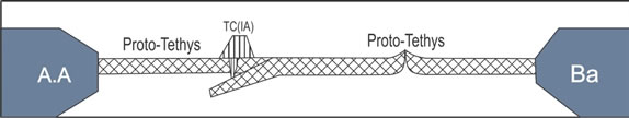
Figure 2. Schematic section of Baltic (Grate Caucasus), Mid Caucasus and Africa-Arabia super continent (Lesser Caucasus) Locations in late protrozoic and intra ocean subduction. (GC: Grate Caucasus, TC: Trans Caucasus and AA: Africa-Arabia super continent).
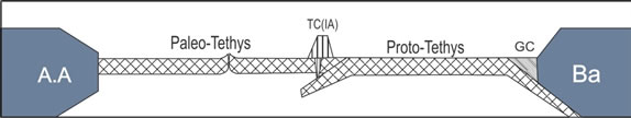
Figure 3. Schematic section of Midcaucasus, prototethys and paleotethys locations in 600 - 800 Ma. Two-sided subduction in Prototethys.
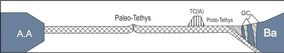
Figure 4. Schematic section of Paleotethys development and Prototethys subduction under Baltic and Great Caucasus. As a single arc with transcrust, Trans Caucasus is approaching to Great Caucasus. Due to inadequate compression caused by reduced Paleotethys development, Under Trans Caucasus subduction is decreased (400 - 500 Ma).
While there are many available signs confirming the northward Prototethys subduction under Baltic which caused Great Caucasus. Ophiolites and Metaophiolites of Great Caucasus confirm this fact. Northward subduction is corroborated by Brunet et al. [18], Allen et al. [19], Adamia et al. [14]. The data obtained from surveying the epicenter of 1973 up to 2012 earthquakes show that at least 20 earthquakes with more than 60 kilometers in depth happened in the center and north of Great Caucasus. Considering the thickness of the crust in Great Caucasus (60 Km [20] and 55 Km [16]), we come into conclusion that a thick skin tectonic happened in the region.
5. Paleozoic
Matching the sedimentary cores show that most of the mosaic terranes of Middle East in Paleozoic have a same origin. Middle east was affected by the evolution of Paleozoic Tethys Oceans, Hun and Cimmeria superterranes and Pangea and Gondwana super continents [8-10,21- 28]. Three important rifts of Paleozoic through Gondwana and Pangea borders are discussed in the model presented by Ruban et al. [13] for Middle East. When Avolunia and Gondwana were separating from each other in early Ordovician, the first rift happened. Since this rift is 6000 kilometers away from the region, it can not affect Middle East. The second period goes back to middle Silurian which contained the division of Hun superterranes. Since some parts of super terranes contain tectonic units of Middle East, this division can affect the region. Permian-Triassic is the third period in which some Cimmeria Middle East terranes were separated from Gondwana or part of Pangea. According to Sharland et al. [4] and Stampfli et al. [7] in Paleozoic up to middle Permian-Triassic (when Cimmeria started to separate and construct Neotethys), the region of Middle East is interpreted like passive Gondwana and Pangea margins. Moreover, two regional unconformities are detected. The first one is the absence of middle Silurian up to middle Devonian (middle Paleozoic hiatus) which sometimes is matched with Caledonian orogeny [29]. The second one contains the absence of middle carboniferous which usually is matched with Hercynian orogeny [30]. This match can not be considered as a model of Paleozoic plate evolution in Middle East, because their locations are in a great distance from the listed orogenies.
Paleozoic tectonic configuration of Middle East is determined by three Gondwana, Lurasia and Pangea super continents [7-10,24,31-35].
In the Middle East model presented by Ruban et al. [13] three proto, paleo and neo Tethys Oceans are considered in Paleozoic period beside Great Caucasus and Lesser Caucasus. They put Prototethys between Lurasia and Hun while Paleotethys is put between Cimmeria and Hun in the model. Considering the facts that Great Caucasus is a part of Hun and Lesser Caucasus with Trans Caucasus are parts of Cimmeria, hence just one subduction can be presented for three Caucasus terranes collision. This model is not compatible with our studies because at least two Ophiolitic sequences, one in Great Caucasus and the other in Lesser Caucasus are observable. Thus, according to the distance between two Caucasus areas and the age difference of the Ophiolites, at least two subductions in two different oceans (proto and paleo Tethys) are considered to Caucasus evolution (Figure 3).
Great Caucasus is now located in south of Russian platform [36,37] and the Paleozoic sedimentary complexes are outcropped in central mountains of it [38]. About 4500 kilometers of volcanic and pyroclastic rocks had been sedimented in middle and late Devonian up to Famenin [39]. Periodic volcanic activities can be a sign of tectonics existing between Great Caucasus and other Hun’s terranes. Magmatic activities are related to the closure of Rheic Ocean [8]. Following the Tawadros et al. [37], Ruban et al. [13] considered Great Caucasus as a subset of Hun superterranes and probably its cordillera. Before Hun’s breakage, the location of Great Caucasus in early Paleozoic is not exactly determined. But without any certain information, Tawadros et al. [37] located it in African-Arabian margin. Great caucuses were located beside the east of Hun Cordillerain middle Paleozoic. It moved to west by strike motions in north of Paleotethys breccia zone in carboniferous-middle Triassic and in late Triassic-early Jurassic to east. Late Paleozoic breccia zone up to Mesozoic also developed along the southern margin of Lurasia and joined to one of the breccia zones inside Pangea [5,8,27,37,40-46]. In Paleozoic period Great and Trans Caucasus had the tectonic characteristics of the volcanoes up subduction zone and the penetration of Granite brought deep regional metamorphism, deformation and orogeny [14].
Northward subduction of Paleotethys under Trans Caucasus along with ignesious materials (caused by partial melting of oceanic crust) penetration affected Trans Caucasus and reduced the density of island arc transcrust. (Figure 5).
Lesser Caucasus is now located in south of Great
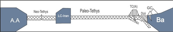
Figure 5. Schematic section of Neotethys opening, Paleotethys subduction, and Trans Caucasus and Great Caucasus collision. A slab of subducted lithosphere is plotted According to the depth of earthquakes (320 Ma).
Caucasus and north of Iran and Turkey. The interpretation of paleomagnetism and Paleontology data show that [47,48] Lesser Caucasus is apparently a separated terranes. Lesser Caucasus along with Cimmeria is separated northward. Ruban et al. [13] suggested that lesser Caucasus was part of Cimmeria. They also concluded that the ancient location of Caucasus was the margin of Gondwana or inside the two remaining super terrans of it. Lesser Caucasus was also considered as a part of Gondwana in Paleozoic [14].
Some slices of oceanic crust (Ophiolite) and trans crust are added to the easternmost part of Europe in late Paleozoic (middle-late carboniferous) [49-51]. The southernmost strip of Great Caucasus crystalline core is determined by metaophiliotic thrust slices [52,53]. These Metaophiolites contain ultrabasic rocks, Gabro-Amphi-boliteand Mica schist, Plagioclase gneiss and Marble. The amphibolite facieses show a high and medium pressure metamorphism. The metaophiolites of Great Caucasus are dated to late Devonian-early Carboniferous which is simultaneous with the closure of Prototethys and complete extension of Paleotethys. This is the reason of Trans Caucasus and Great Caucasus collision in that period because according to our interpretations, the Trans Caucasus crust is a kind of transferring crust. (Figure 5).
• 5.1. The Evidences of Trans and Great Caucasus Collision
• Thrust metaophiolitic slices in southernmost part of Great Caucasus.
• Amphibolites facieses and middle and high pressure metamorphism.
• Slices of oceanic and transcrust addition to easternmost part of Europe in late Paleozoic especially in middle-early carboniferous.
• I and S type Granites from south to northand after Ophiolitic belt in Great Caucasus that represent subduction and collision depression.
Conodonts containing slices of lime exist in Lesser Caucasus Ophiolite belt in middle carboniferous-Permian. They are visible in Gharabagh [54]. It shows that Paleotethys Ocean wasn’t closed in that period. The ophiolites of Paleozoic also are known in Rasht [55,56] Alborz and Binalood [57,58].
6. Mesozoic
Oceanic subduction, obduction, addition of small lithospheric plates and other later motions in Caucasus mostly happened from late Cretaceous to Eocene [8,59]. Some Microplates were attached to Eurasia margin and caused Paleotethys closure during late Triassic-early Jurassic. The northward subduction boundaries developed along this new continental margin in south Pontaides, south Trans Caucasus and Iran. Lesser Caucasus, Sanandaj-Sirjan in Caucasus-Caspian region were joined to Iran during late cretaceous [12]. Lesser Caucasus contained dolomite, Marl and sandstone in Triassic. Trans Caucasus and Great Caucasus are presented by shallow coal containing deposits. The deposits of Jurassic and early cretaceous are rare in Lesser Caucasus. Meanwhile late cretaceous period is wide in this area and shows shallow sea constructions containing clay, Trijenous, organic, sandy-clay and marl Limestones. The sediments of Great and Trans Caucasus contain thickness of 12 - 15 kilometers from Jurassic up to Paleocene. They are deformed: Isoclinal folds, over thrust and thrust, Boodinage, cleavage and small scale nappes.
Rolland et al [60], considered lesser Caucasus as an ocean region with a slow expansion in early middle Jurassic. The northwest Armenia Ophiolites of upper middle Jurassic up to late cretaceous confirms the developing of Lesser Caucasus oceanic crust in this Time [61]. Some slices of Paleotethys crust along the southern border of Trans Caucasus and inside the Ophiolite Sevan-Akra complex in Pontaides are visible [14]. Also the evidences of Paleotethys crust are outcropped in Iran, Garabagh and east Lesser Caucasus [15]. Studying the Sevan-Akra Ophiolites shows a complete circle of Ultramafic-mafic. They are generally dated to upper-Triassic and in northwest Armenia show late Cretaceous. Trans Caucasus was an island-arc unit which moved upward in Triassic up to Eocene [14]. Sevan-Akra Ophiolites are two types: Telloeitic and Benonitic. Both of them show a complete Ophiolite sequence. Ur/Pb dating of Benonites gave an age of 160 Ma. The petrochemical and geochemical data show that the Telloeitic sequence of Sevan-Akra has an origin of up subduction [62]. Studying Jurassic Ophiolites in Armenia show ocean remaining Ophiolite rocks and also show arc type volcanic rocks which are probably from upper cretaceous [63]. Studying Radiolarites of Ophiolite volcanic rocks in three regions of Armenia (east Sevan Lake, northwest Armenia and center of Armenia) suggests the age of middle-upper Jurassic and lower cretaceous. K/Ar dating of Amphibolite-Gabro Ophiolites of Sevan-Akra by Galoyan et al. [63] gave the age of middle Jurassic for them.
Paleotethys, the ocean between Trans Caucasus and Lesser Caucasus, was closing and subducting under Trans Caucasus and Iranin Mesozoic period. But still no collision happened up to the end of Mesozoic between Trans and Lesser Caucasus. The Neotethys Ocean was created and expanded behind Lesser Caucasus and between central Iran and Arabia in the time of middle late Mesozoic. It accelerated the northward subduction of Paleotethys (Figure 6).
There are several different ideas about the direction of Paleotethys subduction. According to Alavi. [64], Trans Caucasus (Moghan) is part of south Caspian oceanic plate and the subduction is northward. According to Sengor, Yılmaz. [59], Rice et al. [65,66], the direction along the sutures of late Mesozoic is to north. Adamia et al. [67], Sengor, Yilmaz [59], Boztug [68], believe that the great thickness of the arc type igneous rocks located on east pontaides crust show northward subduction of Tethys. Vernant et al. [69], Adamia et al. [14] consider the direction to north and Golonka [12], Ruban et al. [13], Hisarli [70], consider it to south. The southward subduction is also presented by Kozur [71] and their followers [72,73]. Brunet et al. [18] believe that during early Eocene, the subduction zone was southward from Lesser Caucasus up to Iran, and during late cretaceous and early Paleocene, the result of this subduction was the appearance of south Armenia and probably Sanandaj Sirjan. According to all field observations, economical geology and tectonic relations, along with evidences like Gharadagh and Sevan and Akra Ophiolites, we assume the southward subduction under Iran for Paleotethys Ocean (Figure 6).
7. Cenozoic
As the rift of carboniferous-early Permian, Neotethys Ocean was constructed in Cimmerid plate during Permian period [74,75]. This ocean located Great India and Australia in one side and Loot, Farh, south of Pamir, Giantang and Southeast Asia in the other side [12].
The oceanic lithosphere subduction under Lesser Caucasus finished at the end of cretaceous. After Ophiolite obduction in Conyaceane [76], the Sevan-Akra suture was constructed in late cretaceous or Paleogene [77]. As a result, the south Armenian continental terran (Lesser Caucasus) got added to the Trans caucasus block [18]. According to Bronet et al. [18], after Sevan-Akra Ophiolite obduction [76] at the end of cretaceous, the down Lesser Caucasus subduction zone got locked. The age of Lesser Caucasus and Eurasia collision is dated to 71 -
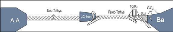
Figure 6. Schematic section of Neotethys development simultaneous with two-sided subduction (as south Caspian) under Lesser Caucasus and Trans Caucasus (65 - 205 Ma).
73.5 Ma by [60]. It is considered as an arc-continental collision by them. At the end of cretaceous or in Paleocene, Lesser Caucasus and probably Sanandaj-Sirjan and Makran joined to Transcaucasus-Talish-South CaspianLoot system [12,77,78]. According to the unconformity of limestone, the age of the ocean closure and the sutures constructions in lesser Caucasus are dated to upper Conyaceane, late cretaceous. While according to Rolland et al. [60], this period belongs to Ophiolites obduction. They probably assumedeast of Ismir-Ankara-Irzinjan suture as the Sevan-Akra suture’s developing direction. They also considered that the age of lesser Caucasus Ophiolites formation in Armenia was compatible with Sevan Ophiolites age.
Some authors believe that Oligocene was the start of collisions in Caucasus extension [79,80] (Figure 7). Great Caucasus, Talish and Lesser Caucasus mountains were constructed at deep basins in this period. By the start of late Miocene up to the end of Pleistocene, volcanic eruptions with surface conditions happened in the central part. Trans Caucasus was separated in to two parts in Peliocene, Drizola dependant on Black Sea in west and Kura dependant on Caspian Sea in east (Figure 8). Except some small terranes, whole Caucasus emerged from water in late Sarmatiane [14]. The Ophiolites of Lesser Caucasus are mostly represented by blue shiest and metamorphosed rocks with amphibolite facies [81].
At the central parts of Caucasus, volcanic eruptions with coarse clastic formations happened in lands in Miocene up to the end of Pleistocene [14]. The amount of different marine fossils in middle Miocene proves that Trans Caucasus was in relation with free water.
8. Discussion and Conclusion
South Caspian is considered as trapped remaining Paleotethys by some of the researchers [82] (Figure 8). Also Priestley et al. [83], consider it as a rigid unseismic block. The history of pre Paleocene is not clear enough and its boundary with south Caspian is not accurately determined [19]. East of great Caucasus is assumed to be affected by westward motion of south Caspian and shortening caused by Arabian-African convergence with Eura-
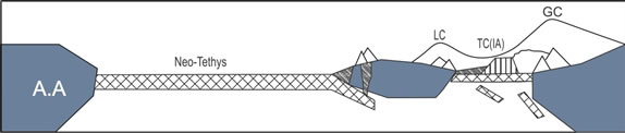
Figure 7. Schematic section of Caucasus collisions and Neotethys subduction and formation of Caucasus folded mountains. (Oligocene). Neotethys closure caused pressure increase which along with the pressure of Arabia made thrust faults in Caucasus folded belt. It is related to post Neotethys closure period. Locating two oceanic crusts on each other in Trans Caucasus justifies the crust thickness in this region.
sia [19].
The formatting process of Today’s structures (Figure 9) (high Caucasus Mountains, intramountain embayment and high volcanos) in this region especially were enhunced from late Miocene. Simultaneous and post collision horizontal shortening caused by northward AfricanArabian plate motion is estimated to hundreds of kilometers. By several methods this remarkable shortening of the earth crust can be justified: 1) Crust deformation along with depressional structures, folds and thrusts developing; 2) slope and displacement of crust blocks along with uplifts, subductions and under thrusting (a process which occasionally is called continental subduction) and 3) Escape tectonic. The northwest Caucasus and Kura tectonic is converted to divide slab subducted tectonic from an indentation tectonic. This demonstrates a rearrangement of deformation zone [84].
According to GPS studies along Great and Lesser Caucasus mountains [85], the least north-south ward shortening rate is specified to be 10 ± 2 mm per year, which
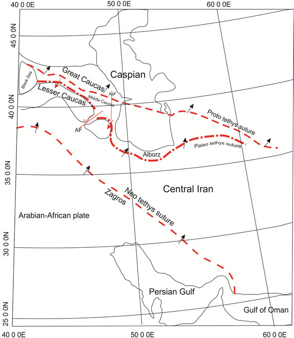
Figure 8. Present location of Tethys and Caucasus cracks. (Subduction directions are indicated by black arrows).
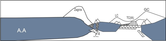
Figure 9. A schematic section from present location of African-Arabian plane, Lesser Caucasus, Great Caucasus and Trans Caucasus after Tethys closures.
60 percent of it is estimated to happen in Great Caucasus [86]. Seismic data show that the Velosity of P and S waves in Talish, under Kura and under south Caspian is high while it is low in west of Kura in Armenia, south of Talish and Alborz [84]. The under Kura high speed anomaly is attributed to an oceanic crust by Zonenshain &Le Pichon [87].
The Following Results Can Be Obtained in a Summary
Today’s basin of Moghan was a part of great Kura-Aras basin and was constructed between two Caucasus regions. Considering tectonically, it is a part of Trans Caucasus and is located under Kura basin. The depth of Moho in Kura varies from 45 to 60 kilometers.
Paleotethys Ocean is located between Great and Lesser Caucasus. Its signs are visible in Iran, Turkey and Armenia. Prototethys Ocean is located between Great and Trans Caucasus with evidences in Great Caucasus. The oceanic subduction in Prototethys constructed island arc Trans Caucasus. The Prototethys subduction under Baltic caused Trans Caucasus and Baltic collision and consequently construction of Great Caucasus. The Paleotethys subduction caused Great and Trans Caucasus collision with northwest margin of Iran and consequently construction of Lesser Caucasus.
The subduction direction creating Great Caucasus was to north and the direction creating Lesser Caucasus was to south. In addition to mentioned signs of southward subduction, some other evidences can be discussed. On one side of Paleotethys, Transcaucasus crust was located and in the other side, Iranian-Arabian continental crust existed. Thus, the excessive density of Iranian-Arabian crust and Paleotethys in comparison with Transcaucasus crust and Paleotethys made southward subduction.
Deep seismic data confirm that in Great and Lesser Caucasus tectonic region change from thin tectonic to thick skin tectonics.
Lesser and Trans Caucasus are poor in deep earthquakes but had surface destructive ones. Deep earthquakes mostly happen in Great Caucasus, Caucasus boundaries and east of this region. Earthquakes in east probably show that brittle section of south Caspian crust is deeping.
Great, Trans and Lesser Caucasus collisions were harder in the center of Caucasus (Armenia region), while it was slight in east and west (Black Sea and Caspian Sea). The reason can be the low distance of Great and Lesser Caucasus in Armenia rather than margins. It illustrates an indentation tectonic. Another reason can be the more expansion of island arc Transcaucasus in east and west which acts as a barrier of Iran penetration to north and Eurasia. If this assumption is considered to be true, this theory can be mentioned that south Caspian and Black Sea crusts are the trapped basins of Iran Eurasia collision.
With more than 1000 km length, the Izmir, Ankara, Arzanjan suture separates Eurasia from Gondwana. This suture limits to Sevan, Akra, Gharabagh, Talish, Rasth and Binalood from east. It is a sign of Paleotethys.
Trans Caucasus is full of hydro carbonic resources. Old crust, thick sediments and igneous intrusions made proper conditions for hydro carbonic formations.
9. Acknowledgements
The authors thank Fazell Khalegi & Yashar Ansari & Nourazar Shokrzadeh for their important comments and suggestions in improving the manuscript.
REFERENCES
- J. Dercourt, L. E. Ricu, S. H. Adamia, G. Gsaszar, H. Funk, J. Lefeld, M. Rakus, M. Sandulescu, A. Tollmann and P. Tchoumachenko, “Anisian to Oligocene Paleogeography of the European Margin of Tethys (Geneva to Baku), Evolution of the Northern Margin of Tethys,” Mémoire de la Sočiété Géologique de France, Vol. 154, 1990, pp.159-160.
- G. M. Stampfli, “Tethyan Oceans,” Geological Society of London, Vol. 173, 2000, pp. 1-23. doi:10.1144/GSL.SP.2000.173.01.01
- E. Barrier and B. Vrielynck, “Paleotectonic Maps of the Middle East,” Middle East Basins Evolution Programme, CGMW, Atlas, 2008, Maps, pp. 1-14.
- P. R. Sharlan, R. Archer, D. M. Casey, R. B. Davies, S. H. Hall, A. P. Heward, A. D. Hurbury and M. D. Simmons, “Arabian Plate Sequence Stratigraphy,” GeoArabia Special Publication (Gulf Petrolink), Bahrain, 2001, p. 371.
- V. A. Bykadorov, V. A. Bush, O. A. Fedorenko, I. B. Filippova, N. V. Miletenko, V. N. Puchkov, A. V. Smirnov, B. S. Uzhkenov and Y. A. Volozh, “OrdovicianPermian Palaeogeography of Central Eurasia: Development of Palaeozoic Petroleum-Bearing Basins,” Journal of Petroleum Geology, Vol. 26, No. 3, 2003, pp. 325-350. doi:10.1111/j.1747-5457.2003.tb00033.x
- P. A. Ziegler, S. Cloetingh, R. Guiraud and G. M. Stampfli, “Peritethyan Platforms: Constraints on Dynamics of Rifting and Basin Inversion,” Memoires du Museum National d Historie Naturelle, Vol. 6, 2001, pp. 51-108.
- G. M. Stampfli, J. Mosar, P. Favre, A. Pillevuit and J. C. Vaney, “Permo Mesozoic Evolution of the Western Tethys Realm: The Neotethys East Mediterranean Basin connection,” Memoires du Museum National d Historie Naturelle, Vol. 186, 2001, pp. 51-108.
- G. M. Stampfli and G. D. Borel, “A Plate Tectonic Model for the Paleozoic and Mesozoic Constrained by Dynamic Plate Boundaries and Restored Synthetic Oceanic Isochrones,” Earth and Planetary science Letters, Vol. 196, No. 1-2, 2002, pp.17-33. doi:10.1016/S0012-821X(01)00588-X
- J. F. Von Raumer, G. M. Stamfli, G. Borel and F. Bussy, Organization of Pre-Variscan Basement Areas at the North Gondwana Margin,” International Journal of Earth Sciences, Vol. 91, No. 1, 2002, pp. 35-52. doi:10.1007/s005310100200
- J. F. VonRaumer, G. M. Stampfli and F. Bussy, “Gondwana-Derived Microcontinents—The Constituents of the Variscan and Alpine Collisional Orogens, Tectonophysics, Vol. 365, No. 1-4, 2003, pp. 7-22. doi:10.1016/S0040-1951(03)00015-5
- I. Metcalfe, “The Ancient Tethys Oceans of Asia: How many? How old? How deep? How wide?” UNEAC Asia papers, No. 1, 1999, pp. 1-9.
- J. Glonka, “Plate Tectonic Evolution of the Southern Margin of Eurasia in the Mesozoic and Cenozoic,” Tectonophysics, Vol. 381, No. 1-4, 2004, pp. 235-273. doi:10.1016/j.tecto.2002.06.004
- D. A. Ruban, M. Al Husseini and Y. Iwasaki, “Review of Middle East Paleozoic Plate Tectonics,” GeoArabia, Vol. 12, No. 3, 2007, pp. 35-56.
- Sh. Adamia, G. Zakaridze, T. Chkhatua, M. Sadradze, M. Tseretelir, A. Chabukiani and A. Gventsadzeh, “Geology of the Caucasus: A Review,” Turkish Journal of Earth Sciences, Vol. 20, No. 5, 2011, pp. 489-544.
- M. Rustamov, “South Caspian Basin-Geodynamic Events and Processes,” Institute of Geology NASA, Baki, 2004, pp. 46-71.
- L. A. Buryakovsky, G. V. Chilingar and F. Aminzadeh, “Petroleum Gology of the South Caspian Basin,” Gulf Professional Publishing, Houston, 2001.
- A. A. Ali-Zade, V. E. Khain and A. D. Ismail-Zade, “The Saatly Ultra-deep Well, The Study of Deep Structure of the Kura Intermontane Depression According to the Data of the Drilling of the Saatly Ultra-Deep Well SG-1,” Nafta-Press, Baku, 1999.
- M. F. Brunet, M. V. Korotaev, A. V. Ershov and A. M. Nikishin, “The South Caspian Basin: A Review of Its Evolution from Subsidence Modeling,” Journal of Sedimentary Geology, Vol. 156, No. 1-4, 2003, pp. 119-148. doi:10.1016/S0037-0738(02)00285-3
- M. B. Allen, S. J. Vincent, G. I. Alsop, A. Ismail zadeh and R. Flecker, “Late Cenozoic Deformation in the South Caspian Region: Effects of a Rigid Basement Block within a Collision Zone,” Journal of Tectonophysics, Vol. 366, No. 3-4, 2003, pp. 223-239. doi:10.1016/S0040-1951(03)00098-2
- C. Ruppel and M. McNutt, “Regional Compensation of the Greater Caucasus Mountains Based on an Analysis of Bouguer Gravity Data,” Earth and Planetary Science, Vol. 98, No. 3-4, 1990, pp. 360-379. doi:10.1016/0012-821X(90)90037-X
- A. M. C. Sengor, “A New Model for the Late Palaeozoic -Mesozoic Tectonic Evolution of Iran and Implications for Oman,” Geology Society of London, Special Publication, No. 49, 1990, pp. 797-831.
- G. Stampfli, “The Intra-Alpine Terrain: A Palaeotethyan Remnat in the Alpine Variscides,” Ecloga Geologicae Helvetiae, Vol. 89, 1996, pp. 12-42.
- J. Von Raumer, “The Palaeozoic Evolution in the Alps: From Gondwana to Pangea,” Geologische Rundshau, Vol. 87, No. 3, 1998, pp. 407-435. doi:10.1007/s005310050219
- L. R. M. Cocks and T. H. Torsvik, “Earth Geography from 500 to 400 Million Years Ago: A Faunal and Palaeomagnetic Review,” Journal of the Geological Society of London, Vol. 159, No. 6, 2002, pp. 631-644. doi:10.1144/0016-764901-118
- G. M. Stampfli, J. von raumer and G. D. Borel, “The Palaeozoic Evolution of Pre-Variscan Terranes: From Peri Gondwana to the Variscan Collision,” Geological Society of America, Special Paper, No. 364, 2002, pp. 263-280.
- T. H. Torsvik and L. R. M. Cocks, “Earth Geography from 400-250 Ma: A Palaeomagnetic, Faunal and Facies Review,” Journal of Geology Society of London, Vol. 161, No. 4, 2004, pp. 555-572. doi:10.1144/0016-764903-098
- B. A. Natal’in and A. M. C. sengor, “Late Palaeozoic to Triassic Evolution of the Turan and Scythian Platforms; The Pre-History of the Palaeo-Tethyan Closure,” Tectonophysics, Vol. 404, No. 3-4, 2005, pp.175-202. doi:10.1016/j.tecto.2005.04.011
- P. Xypolias, W. Dorr and G. Zulauf, “Late Carboniferous Plutonism within the Pre-Alpine Basement of the External Hellenides (Kithira,Greece): Evidence from U-Pb Zircon Dating,” Journal of the Geological Society of London, Vol. 163, No. 3, 2006, pp. 539-547. doi:10.1144/0016-764904-114
- T. Buday, “The Regional Geology of Iraq: Tectonism, Magmatism and Metamorphism,” State Organization for Minerals, Baghdad, 1980, 445 p.
- M. Berberian and G. C. P. King, “Towards the Paleogeography and Tectonic Evolution of Iran,” Canadian Journal of the Earth Sciences, Vol. 18, No. 2, 1981, pp. 210-265. doi:10.1139/e81-019
- P. Courjault-Rade, F. Debrenne and A. Gandian, “Palaeogeographic and Geodynamic evolution of the Gondwana Continental margins during the Cambrian,” Terra Nova, Vol. 4, No. 6, 1992, pp. 657-667. doi:10.1111/j.1365-3121.1992.tb00615.x
- L. R. M. Cocks, “Ordovician and Silurian Global Geography,” Journal of the Geological Society of London, Vol. 158, No. 2, 2001, pp. 197-210. doi:10.1144/jgs.158.2.197
- R. A. Fortey and L. R. M. Cocks, “Palaeontological Evidence Bearing on Global Ordovician-Silurian Continental Reconstruction,” Earth-science Reviews, Vol. 61, No. 3-4, 2003, pp. 245-307. doi:10.1016/S0012-8252(02)00115-0
- C. R. Scotese, “A Continental Drift Flipbook,” Journal of Geology, Vol. 112, No. 6, 2004, pp. 729-741. doi:10.1086/424867
- D. Avigad, A. Sandler, K. Kolodner, R. J.stern, M. Mc Williams, N. Miller and M. Beyth, “Mass-Production of Cambro-Ordovician Quartz-Rich Sandstone as a Consequence of Chemical Weathering of Pan-African Terranes: Environmental Implications,” Earth and Planetary Science Letters, Vol. 240, No. 3-4, 2005, pp. 818-826. doi:10.1016/j.epsl.2005.09.021
- I. P. Gamkrelidze, “Terranes of the Caucasus and Adjacent Areas,” Bulletin of Georgian Academy of Science, Vol. 155, No. 3, 1997, pp. 391-394.
- E. Tawadros, D. A. Ruban and M. Efendyeva, “Evolution of NE Africa and the Greater Caucasus: Common Pattern and Petroleum Potential, the Canadian Society of Petroleum Geologist, the Canadian Society of Exploration Geophysicist,” The Canadian Well Logging Society Joint Convention, Calgary, 15-18 May 2006, pp. 531-538.
- D. A. Ruban, “Diversity Changes of the Brachiopods in the Northern Caucasus: A Brief Overview,” Acta Geologica Hungarica, Vol. 49, No. 1, 2006, pp. 57-71. doi:10.1556/AGeol.49.2006.1.4
- D. S. Kizevalter and V. N. Robinson, “Devonskaja Sistema Srtatigrafija SSSR,” Nedra, Moscow, 1973, pp. 220-229.
- F. Arthaud and P. Matte, “Late Paleozoic Strike-Slip Faulting in Southern Europe and Northern Africa: Result of a Right-Lateral Shear Zone between the Appalachian and the Urals,” Geological Society of America Bulletin, Vol. 88, No. 9, 1977, pp. 1305-1320. doi:10.1130/0016-7606(1977)88<1305:LPSFIS>2.0.CO;2
- M. T. Swanson, “Preliminary Model for an Early Transform History in Central Atlantic Rifting,” Geology, Vol. 10, No. 6, 1982, pp. 317-320. doi:10.1130/0091-7613(1982)10<317:PMFAET>2.0.CO;2
- A. E. Rapalini and H. Vizan, “Evidence of Intrapangaea Movements in Gondwanaland, Comptes Rendus. XII ICC-p,” GeoArabia, Journal of the Middle East Petroleum Geosciences, Vol. 1, No. 1, 1993, pp. 405-434.
- L. A. Lawver, A. Grantz and L. M. Gahagan, “Plate Kinematic Evolution of the Present Arctic Region since the Ordovician,” Geological Society of America, Special Paper, Vol. 360, 2002, pp. 333-358.
- G. B. Vai, “Development of the Palaeogeography of Pangaea from Late Carboniferous to Early Permian,” Palaeogeography, Palaeoclimatology, Palaeoecology, Vol. 196, No. 1-2, 2003, pp. 125-155. doi:10.1016/S0031-0182(03)00316-X
- Z. Garfunkel, “Origin of the Eastern Mediterranean Basin: A Reevaluation,” Tectonophysics, Vol. 391, No. 1-4, 2004, pp. 11-34.
- D. A. Ruban and S. Yoshioka, “Late Paleozoic Early Mesozoic Tectonic Activity within the Donbass (Russian Platform),” Trabajos de Geolga, Vol. 1, No. 25, 2005, pp. 101-104.
- M. B. Lordkipanitze, S. H. Adamia and B. Z. Asanidze, “Paleookeanologija,” 27 Mezhdunarodnyj Geologitscheskij Congress, Doklady Nedra, Moskva, 1984, pp. 72-83.
- I. P. Gamkrelidze, “Geodynamic Evolution of the Caucasus and Adjacent Areas in Alpine Time,” Tectonophysics, Vol. 127, No. 3-4, 1986, pp. 261-277. doi:10.1016/0040-1951(86)90064-8
- S. H. Adamia and I. Shavishvili, “Root Zone of the Ophiolite Nappes of the Western Caucasus,” Doklady of Academy of Sciences of the USSR, Vol. 267, 1982, pp. 1424-1425.
- A. Belov and V. O. L. Omelchenko, “Late Variscan and Post-Variscan Thrusts in the Pre-Upper Jurassic Basement of the Northern Caucasus,” Izvestia VUZ (Institute of Higher Education), Series Geological and Mineral Resources, Vol. 9, 1986, pp. 14-20.
- M. Somin, “Main Features of Structures of the Pre-Alpine Basement of the Great Caucasus,” Rocks Complexes and Geodynamics of the Main Stages of Evolution of the Great Caucasus, GEOS, Moscow, 2007, pp. 10-52.
- S. H. Adamia, M. Abesadze, M. Kekelia, T. Chkhotua and I. Shavishvili, “Metaophiolites, Island-Arc Complexes and Blastomilonites of the Main Range of the Great Caucasus,” Doklady of Academy of Sciences of the USSR, Vol. 241, 1978, pp. 1139-1142.
- S. H. Adamia, B. Asanidze, T. Chkhotua, M. Kekelia, I. Shavishvili, G. Tsimakuridze and G. Zakariadze, “Fragments of Paleo-Tethyan Terranes in the Crystalline Core of the Great Caucasus,” Proceedings of the 5th International Symposium on Eastern Mediterranean Geology, Thessaloniki, 14-20 April 2004, pp. 233-236.
- I. Kariakin and V. O. L. Aristov, “On the Age and Geological Position of ‘Exotic Rocks’ of Rogachai Zone (Lesser Caucasus),” Doklady of Academy of Sciences of the USSR, Vol. 311, 1990, pp. 1189-1193.
- B. Majidi, “The Ultrabasic Lava Flows of Mashhad, North-East Iran,” Geological Magazine, Vol. 118, No. 1, 1979, pp. 49-58. doi:10.1017/S0016756800024791
- M. Davoudzadeh and K. Shmidt, “Contribution to the Paleogeography and Stratigraphy of the Upper Triassic to the Middle Jurassic of Iran,” Neues Jahrbuch für Geologie und Paläontologie, Vol. 162, No. 2, 1981, pp. 137-163.
- N. Lyberis and G. Manby, “Oblique to Orthogonal Convergence across the Turan Block in the Post-Miocene,” AAPG Bulletin, Vol. 83, No. 7, 1999, pp. 1135-1160.
- A. Zanchi, S. Zanchetta, F. Berra, M. Mattei, E. Garzanti, I. Villa, S. Molinex, A. Nawab and J. Sabouri, “The EoCimmerian Collision between North Iranian and the Southern Portion of Eurasia: New Constraints from the Alborz-Kope Dag Regions,” International Symposium on Middle East Basins Evolution, Paris, 4-5 December 2007, pp. 17-18.
- A. M. C. Sengor and Y. Yilmaz, “Tethyan Evolution of Turkey: A Plate Tectonic Approach,” Tectonophysics, Vol. 75, No. 3-4, 1981, pp. 181-241. doi:10.1016/0040-1951(81)90275-4
- Y. Rolland, S. Billo, M. Corsini, M. Sosson and G. Galoyan, “Blueschists of the Amassia-Stepanavan Suture Zone (Armenia): Linking Tethys Subduction History from E-Turkey to W-Iran,” International Journal of Earth Science, Vol. 98, No. 3, 2009, pp. 533-550. doi:10.1007/s00531-007-0286-8
- T. Danelian, G. Asatryan, M. Sosson, G. Galoyan, A. Avagyan, L. Sahakyan and Y. Rolland, “New Paleontological (Radiolarian) Age Constraints for the Sedimentary Cover of Ophiolites in the Lesser Caucasus (Armenia),” International Symposium on Middle East Basins Evolution, Paris, 4-5 December 2007, p. 47.
- O. G. Bogdanovski, G. S. Zakariadze, S. F. Karpenko, S. K. Zlobin, V. M. Pukhovskaya and V. Yu. Amelin, “SmNd Age of the Gabbroids of a Tholeiitic Series of the Ophiolites of the Sevan-Akera Zone of the Lesser Caucasus,” Academy of Sciences Russia, Vol. 327, 1992, pp. 566-569.
- G. Galoyan, Y. Rolland, M. Sosson, M. Corsini and R. Melkonyan, “Evidence for superimposed MORB, Oceanic Plateau and Volcanic Arc Series in the Lesser Caucasus (Stepanavan, Armenia),” Comptes Rendus Geoscience, Vol. 339, No. 7, 2007, pp. 482-492.
- M. Alavi, “Sedimentary and Structural Characteristics of the Paleo-Tethys Remnants in Northeastern Iran,” Geological Society of America Bulletin, Vol. 103, No. 8, 1991, pp. 983-992. doi:10.1130/0016-7606(1991)103<0983:SASCOT>2.3.CO;2
- S. P. Rice, A. H. F. Robertson and T. Ustaömer, “Late Cretaceous-Early Cenozoic Tectonic Evolution of the Eurasian Active Margin in the Central and Eastern Pontides, Northern Turkey,” Geological Society, Special Publications, Vol. 260, 2006, pp. 413-445.
- S. P. Rice, A. H. F. Robertson, T. Ustaomer, N. Inan and K. Tasli, “Late Cretaceous—Early Eocene Tectonic Development of the Tethyan Suture Zone in the Erzincan Area, Eastern Pontides, Turkey,” Geological Magazine, Vol. 146, No. 4, 2009, pp. 567-590. doi:10.1017/S0016756809006360
- S. H. Adamia, M. Lordkipanidze and G. Zakariadze, “Evolution of an Active Continental Margin as Exemplified by the Alpine History of the Caucasus,” Tectonophysics, Vol. 40, No. 3-4, 1977, pp. 183-199.
- D. Boztug, “Timing of Magnetic Episodes in the Composite Kackar Batholiths, Eastern Pontides, Turkey,” 2nd International Symposium on the Geology of the Black Sea region (ISGB), Ankara, 5-9 October 2009, pp. 35-36.
- P. F. Vernant, J. Nilforoushan, R. Chery, Y. Bayer, F. Djamour, H. Masson, J. Nankali, F. Ritz, M. Sedighi and F. Tavakoli, “Deciphering Oblique Shortening of Central Alborz in Iran using Geodetic Data,” Earth and Planetary Science Letters, Vol. 223, No. 1-2, 2004, pp. 177-185. doi:10.1016/j.epsl.2004.04.017
- Z. M. Hisarli, “New Paleomagnetic Constraints on the Late Cretaceous and Early Cenozoic Tectonic History of the Eastern Pontides,” Journal of Geodynamics, Vol. 52, No. 2, 2010, pp. 114-128. doi:10.1016/j.jog.2010.12.004
- H. Kozur, “The Evolution of the Meliata-Hallstatt Ocean and Its Significance for the Early Evolution of the Eastern Alps and Western Carpathians,” Palaeogeography, Palaeoclimatology, Palaeoecology, Vol. 87, No. 1-4, 1991, pp. 109-130. doi:10.1016/0031-0182(91)90132-B
- H. Kozur and R. Mock, “New Paleogeographic and Tectonic Interpretations in the Slovakian Carpathians and Their Implications for Correlations with the Eastern Alps and Other Parts of the Western Tethys: Part II. Inner Western Carpathians,” Mineralia Slovaca, Vol. 26, 1997, pp. 164-209.
- U. G. Wortmann, H. Weissert, H. Funk and J. Hauck, “Alpine Plate Kinematics Revisited: The Adria Problem,” Tectonics, Vol. 20, No. 1, 2001, pp. 134-147.
- J. Golonka, M. I. Ross and C. R. Scotese, “Phanerozoic Paleogeographic and Paleoclimatic Modeling Maps,” Memoir-Canadian Society of Petroleum Geologists, Vol. 17, No. 1, 1994, pp. 1-47.
- A. M. C. Sengor and B. A. Natalin, “Paleotectonics of Asia: Fragment of a Synthesis,” Cambridge University Press, Cambridge, 1996.
- A. L. Knipper, A. Ya. Sharaskin and A. I. Voznesenskii, “Ophiolite Clastic Breccias of the Lesser Caucasus: Structural Features and Origin,” Geotectonics, Vol. 35, No. 3, 2001, pp. 199-206.
- A. L. Knipper and S. D. Sokolov, “Pre-Upper Senonian Tectonic Sheets in the Lesser Caucasus,” Geotectonics, Vol. 1, No. 6, 1974, pp. 357-361.
- S. A. Adamia, “The Caucasus Oil and Gas Province,” Earth Science and Resources Institute, Vol. 7, No. 1-2, 1991, pp. 53-74.
- A. Saintot, M. Brunet, F. Yakovlev, M. Sebrier, R. Stephenson, A. Ershov, F. Chalot-Prat and T. McCann, “The Mesozoic-Cenozoic Tectonic Evolution of the Greater Caucasus,” Geological Society, London, Memoirs, Vol. 32, No. 1, 2006, pp. 277-289.
- S. Vincent, M. Allen, A. Ismail-Zadeh, R. Flecker, K. Foland and M. Simmons, “Insights from the Talysh of Azerbaijan into the Paleogene Evolution of the South Caspian Region,” Geological Society of America Bulletin, Vol. 117, No. 11-12, 2005, pp. 1513-1533. doi:10.1130/B25690.1
- V. O. L. Agamalian, “The Lesser Caucasus Earth Crust Formation and Evolution in the Collision Zone of PaleoTethys,” Proceedings of the 5th International Symposium on Eastern Mediterranean Geology, Thessaloniki, 14-20 April 2004, pp. 17-20.
- R. S. Nadirov, E. Bagirov, M. Tagiyev and I. Lerche, “Flexural Plate Subsidence, Sedimentation Rates, and Structural Development of the Super-deep South Caspian Basin,” Marine and Petroleum Geology, Vol. 14, No. 4, 1997, pp. 383-400. doi:10.1016/S0264-8172(96)00054-2
- K. Priestley, C. Baker and J. Jackson, “Implications of Earth-Quake Focal Mechanism Data for the Active Tectonics of the South Caspian Basin and Surrounding Regions,” Geophysical Journal International, Vol. 118, No. 1, 1994, pp. 111-141.
- F. Masson, Y. Djamour, S. Van Gorp, J. Chery, M. Tatar, F. Tavakoli, H. Nankali and P. Vernant, “Extension in NW Iran Driven by the Motion of the South Caspian Basin,” Earth and Planetary Science Letters, Vol. 252, No. 1-2, 2006, pp. 180-188. doi:10.1016/j.epsl.2006.09.038
- R. E. Reilinger, S. C. McClusky, B. J. Souter, M. W. Hamburger, M. T. Prilepin, A. Mishin, T. Guseva and S. Balassanian, “Preliminary Estimates of Plate Convergence in the Caucasus Collision Zone from Global Positioning System Measurements,” Geophysical Research Letters, Vol. 24, No. 14, 1997, pp. 1815-1818. doi:10.1029/97GL01672
- S. McClusky, S. Balassanian, A. Barka, C. Demir, S. Ergintav, I. Georgiev, O. Gurkan, M. Hamburger, K. Hurst, H. Kahle, K. Kastens, G. Kekelidze, R. King, V. O. L. Kotzev, O. Lenk, S. Mahmoud, A. Mishin, M. Nadariya, A. Ouzounis, D. Paradissis, Y. Peter, M. Prilepin, R. Relinger, I. Sanli. H. Seeger, A. Tealeb, M. N. Toksoz and G. Veis, “Global Positioning System Constraints on Plate Kinematics and Dynamics in the Eastern Mediterranean and Caucasus,” Journal of Geophysical Research, Vol. 105, No. B3, 2000, pp. 5695-5719.
- L. P. Zonenshain and X. Pichon, “Deep Basins of the Black Sea and Caspian Sea as Remnants of Mesozoic Back-Arc Basins,” Tectonophysics, Vol. 123, No. 1-4, 1986, pp. 181-211. doi:10.1016/0040-1951(86)90197-6