Open Access Library Journal
Vol.04 No.07(2017), Article ID:78042,39 pages
10.4236/oalib.1103745
Classification and Characterization of Landscapes in the Territory of Adilabad District, Telangana, Deccan Region, India
Medagam Thirupathi Reddy1*, Someswara Rao Pandravada2, Natarajan Sivaraj2, Venkateswaran Kamala2, Neelam Sunil2, Nilamani Dikshit3
1Vegetable Research Station, Sri Konda Laxman Telangana State Horticultural University, Hyderabad, India
2National Bureau of Plant Genetic Resources, Regional Station, Hyderabad, India
3National Bureau of Plant Genetic Resources, Regional Station, Dr. PDKV Campus, Akola, India

Copyright © 2017 by authors and Open Access Library Inc.
This work is licensed under the Creative Commons Attribution International License (CC BY 4.0).
http://creativecommons.org/licenses/by/4.0/


Received: June 16, 2017; Accepted: July 25, 2017; Published: July 28, 2017
ABSTRACT
We are in the Anthropocene and recent studies have revealed that conventional land management strategies diminished natural landscapes and created anthropogenic ones. The classification and characterization of landscapes, therefore, provide a mechanism for quantifying anthropogenic changes to the landscape systems in the Anthropocene. This study was aimed at classifying and characterizing landscapes in the territory of Adilabad District, Telangana, Deccan region, India, which was selected as the area of case study. It was a multi-method approach, where ecogeographic and environmental data were gathered using user/visual-based approach, while socio-economic data were gathered through direct observations, interviews, focus group discussions, questionnaires and literature surveys. The data were analyzed using descriptive and inferential statistics. The study was undertaken by National Bureau of Plant Genetic Resources, Regional Station, Rajendranagar in collaboration with Vegetable Research Station, Rajendranagar during 2010-2012. In the District, a very wide range of land use types was observed. In the last 60 years, the District’s landscape has undergone a remarkable transformation and fragmentation as a consequence of anthropogenic activities like deforestation, agriculture expansion, intensive agriculture, transport infrastructure, urbanization, trade, tourism and recreation. The results revealed that there is a growing body of evidence supporting the hypothesis that the geographical space, which is a mosaic of natural and anthropogenic landscapes (semi-natural and artificial landscapes), is limited in the District. Hills, valleys, forests, rivers, streams, waterfalls and lakes were certain natural landscapes with little or no human impact found in the District. Traditional land management strategies including burning and clearing practiced by indigenous tribal communities, the native inhabitants of the area, have diminished natural landscapes and created semi-natural and artificial landscapes. Complex interactions between humans and nature resulted in a rich amalgam of anthropogenic landscapes and new ecosystems and habitats were created in urban, rural and tribal areas. The artificial landscapes are classified into three main categories: urban, rural and tribal landscapes based on the dominant human societies inhabiting them in the District. Our study identifies the same importance to all types of landscapes: thus natural, semi-natural, tribal, rural, urban landscapes are the key factors in cultural identity of the District. Our work on landscape analysis as a tool for the strategic assessment of the case study area enabled us to use user/visual-based approach based on the assessment of the visual fields of the District.
Subject Areas:
Ecosystem Science
Keywords:
Anthropogenic Landscapes, Cultural Landscapes, Landscape Dynamics, Landscape Ecology, Landscape History, Land Use Changes, Natural Landscapes, Rural Landscapes, Semi-Natural Landscapes, Tribal Landscapes, Urban Landscapes

1. Introduction
A landscape is determined by all the visible features of an area of land, often considered in terms of their aesthetic appeal. It includes the non-living physical elements of geo-physically defined landforms such as mountains, hills and water bodies such as rivers, lakes and ponds, and the living elements of land cover including indigenous vegetation forests flora and fauna and human elements including different forms of land use, buildings and structures, and transitory elements such as lighting and weather conditions. Landscape boundaries can coincide with visual catchments or land type boundaries. Small landscapes can nest within larger landscapes and are scale dependent (District and Local Scale). Landscapes are the most important elements in building spatial identities and the concept of resource limitation can be applied in landscape ecology [1] . Landscapes are composed of different types of land cover which each occupies a fraction of a geographical space, which could and should be considered as a limited resource [1] . The use of space by one land cover type reduces the remaining space available to other types [1] . Landscape can be defined as from one point of view enter into the framework of a view that they produce a combination of natural and cultural assets [2] . Landscapes are dynamic systems constantly modified by the interaction of natural and cultural processes and abiotic environment. These interactions emerge as a spatial configuration of land and vegetation patterns, which in turn influence the flow of energy, matter and species in the system. Landscapes, with their natural and cultural features can usually provide information about the way of life of the people. Perceptions of landscape are rooted in history and local, regional and national cultures, and usually vary over time for the viewer and between different users of landscape, such as between farmers, environmentalists and urban dwellers [3] . Landscape has become an essential component in the integrated management of resources and territories. They are used in a sustainable manner for future generations and make sense economically.
Land use is nothing but human use of land, which involves management and modification of natural environment into fields, pastures, settlements, etc. Land cover is the physical material on the earth’s surface, which includes grass, trees, ground, water, etc. The assessment of land use of landscape is widely used in landscape science [4] [5] . Anthropogenic effects refer to those land use and land cover dynamics which are caused by human activities. Since man replaces natural land covers by anthropogenic ones and since this substitution is not a random one, landscape patterns can be used to detect anthropogenic influences. Earth’s landscape is highly fragmented as a result of deforestation, agriculture expansion, intensive agriculture, transport infrastructure, industrialization and urbanization. Historically, noticeable anthropogenic effects are accepted to be associated with the start of agriculture. It is evident that also earlier in time, i.e., before the invention of agriculture, anthropogenic effects would have occurred, however due to the low population density, the local (or even sub-patch) character of the land cover changes and the non-sedentary character of the populations involved, they can be accepted of little or no significance. However, with the rapid expansion of human population and associated land use, concerns have been raised about the influence of anthropogenic landscape features [6] .
We are in the Anthropocene [7] , which refers to the onset of a new geological era in which humans have become dominant. In this Anthropocene age, humans dominate earth’s landscapes to an extent greater than ever before [8] [9] by changing natural systems on every possible scale [10] . For millennia, human actions have been shaping the world to the degree that they are inscribed in the geological and ecological records [7] . More than 75% of the earth’s ice-free land shows evidence of alteration as a result of human residence and land use, with less than a quarter remaining as wild lands [11] . Recently, this has been occurring with increasing speed and influence which means we need to be asking integrative and effective questions about the world and how we relate to it. Anthropogenic activities that require much space and which destroy or replace original land covers will consequently dominate human-driven landscape dynamics; they are considered exogenous disturbances [12] [13] . This human impact on ecosystems and landscapes has lead to the recognition of anthropogenic biomes, grouped in dense settlements, villages, croplands, rangelands and forested areas [11] . The identification of anthropogenic landscapes, therefore, provides a mechanism for quantifying anthropogenic changes to the landscape systems in the Anthropocene. Anthropogenic change of landscapes confirms the status of geographical space as a limited resource [1] . To manage this resource effectively, it is essential that it be classified and characterized so that planners have an inventory, and a frame of reference for communication and research.
Human niche construction has broad and deep effects not just on landscapes and environments, but on myriad other beings sharing space with us [7] . Humans are self-appointed ecosystem managers and lead actors in seeking sustainability for planetary and local ecosystems [7] . The human imprint on the global environment has now become so large and active that it rivals the great forces of nature in its impact on the functioning of the system of the earth [10] . We are really now in a kind of a hybrid earth, of a nature injected with human will, however responsibly or irresponsibly that may have been exercised [14] . It is no longer possible to understand, predict, or successfully manage ecological pattern, process, or change without understanding why and how humans reshape these in the long term [15] . Understanding, predicting and adjusting to changing landscapes increasingly altered by humans constitute pressing challenges that fall squarely within the purview of Earth surface science. The challenges facing all urban, rural and tribal landscapes stem from the closely interlinked pressures on the economy, ecosystems and human health. This calls for an integrated approach to urban, rural and tribal landscape planning in which government departments need to foster greater collaboration and communication.
Globally, most landscapes are blends of human activities with the expression of biodiversity [16] . From a birds-eye view, the landscape in India is an apparent expression of complex human-environment interactions. Globally, agriculture is the major form of anthropogenic land use [17] . In India, the fate of biodiversity is intimately linked to agricultural land use. Yet both traditional and urban societies derive a mixture of instrumental, existence and bequest values from agrobiodiversity [18] [19] . Widespread human modification and conversion of land has led to loss and fragmentation of natural ecosystems, altering ecological processes and causing declines in biodiversity [20] . Anthropogenic landscapes are receiving increasing attention in developing world conservation [21] [22] [23] . A landscape-scale approach significantly broadens the 20th century practice of conservation. In order to accomplish this, there is a need to better understand how anthromes are shaped, inhabited and altered. To this end, we present an example of landscapes in the territory of Adilabad District, Telangana, Deccan Region, India. As yet, there have been no ecogeographic surveys to identify the landscapes within this territory.
This publication concentrates on the classification and characterization approaches and principles for landscapes in the territory of the case study area. Classification of landscape is important task for study and mapping of landscapes. Many classifications of landscapes have been developed [24] [25] . Landscapes are divided into three basic groups as natural, semi-natural and cultural (artificial) [24] . Geographic sciences have adopted the following classification of landscapes: natural, anthropogenic and cultural landscapes [25] . By natural and semi-natural we understand here the natural vegetation or the semi-natural one from a region of landscape interest or biologic interest. Hills, valleys, forests, rivers and lakes are natural landscapes [26] . Urban, recreational, agricultural and industrial areas form artificial landscapes [27] . Landscape classification is classification of landscape into internally homogeneous and well interpretable biogeographical and ecological units. Landscape classification is the process of defining and mapping landscapes which require special protection and management because of their elevated values. This subject has been a traditional focus of researchers worldwide across all spatial scales, because such units provide a useful framework for both ecological research and environmental management. Landscape characterization is the process of sorting the landscape into different types or areas using selected criteria but without attaching relative values to the same. This provides valuable data on the attributes and key characteristics that contribute to character of the landscape. It involves the review of a range of existing information, including existing landscape studies for the District, field work, other research documents and input from related technical experts. Landscape characterization is not an evaluative process, but it is a valid basis for evaluation. Besides it also provides a useful spatial basis for determining the extent of natural and anthropogenic landscapes (i.e., where the landscape lines should be drawn). Further, careful analysis and evaluation of various socioeconomic, environmental and scientific issues is essential so that agricultural activities could be reoriented towards better use of local resources and their sustainable management in landscapes. Hence, an attempt was made to understand the complexity of the interactions among the different elements in the agro-ecosys- tem, in particular, between the economic, social, and environmental elements interacting on the diversity of habitat types within the agro-ecosystems in urban, rural and tribal areas. We propose the first classification of the landscapes of Adilabad District based on ecogeographic surveys. We show how knowledge of past human activities leads to better understanding of history, ecology and landscape dynamics; and how an improved understanding of all elements including intrinsic natural and cultural heritage can contribute to management planning processes.
Keeping in view the above, the objective of this paper is to give agricultural, environmental and development practitioners a basic understanding of the history, ecology, dynamics, classification and characterization of landscapes in the territory. Against this background, the main aims of this study were 1) to study the history, ecology and dynamics of landscapes; 2) to study the classification and characterization of landscapes in the territory of Adilabad District, Telangana, Deccan Region, India.
2. Materials and Methods
2.1. Ethics Statement
No specific permits were required for the described ecogeographic surveys. The field studies had essentially no effect on local human or animal populations.
2.2. Selection and Characterization of the Case Study Area
Based on literature survey and website searches, we selected Adilabad District, Telangana, located on the northwestern periphery of the Deccan Region, India as the case study area. DIVA-GIS version 7.5.0, free downloadable software [28] was used to map the case study area in the map of India (Figure 1) and Deccan Region (Figure 2). Adilabad District is one of the 17 Districts included in Deccan Region. This region, covering Telangana, Maharashtra and Karnataka, is one of the 22 agrobiodiversity hotspots of India, and well-known for its species richness, endemism, taxonomic uniqueness, unusual ecological or evolutionary phenomena and global rarity [29] . The shape of the District is almost rectangular in East to West direction [30] . Adilabad is located in the Deccan Plateau, hilly regions, pediplain and fluvial regions. Adilabad is situated between 18˚40 and 19˚56N latitudes and 77˚47 and 80˚00E longitudes. Adilabad is the northern-most District of Telangana. It is bounded on the North by Yavathmal and Chandrapur Districts, East by Chandrapur, and West by Nanded District of Maharashtra State and on the South by Nizamabad and Karimnagar Districts of Telangana [31] . It is endowed with rich natural resources such as land, water, forests and minerals. Adilabad is with subtropical climate. The Adilabad District lies within the humid and sub humid tropical rain forest zone with diverse relief,

Figure 1. DIVA-GIS mapping of the Adilabad District in the map of India.
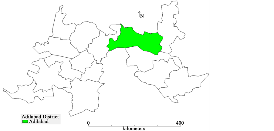
Figure 2. DIVA-GIS mapping of the Adilabad District in the map of Deccan Region, India.
climate and vegetation [32] . The annual average rainfall is 900 - 1137 mm mostly by south-west monsoon [31] . The climate of the District is characterized by hot summers; the climate is generally dry except during the south-west monsoon season [33] . The minimum and maximum temperatures range between 5˚C and 52˚C [34] . The maximum and minimum temperatures during south-west monsoon range from 32˚C - 37˚C and 21˚C - 25˚C, respectively [31] .
2.3. Data Collection
The studies were undertaken by National Bureau of Plant Genetic Resources, Regional Station, Rajendranagar in collaboration with Vegetable Research Station, Rajendranagar during 2010-2012. This paper uses a multi-method approach, with a strong focus on field survey work and participatory methods, combined to capture several aspects of the social, economic, ecological and environmental elements in the natural and anthropogenic landscapes.
Landscapes occurring across the case study area were assessed and classified to identify natural and anthropogenic landscapes. In the late 1990s, the practice of assessing landscape qualities evolved into a combination of expert-based and visual-based (user-based) methods [35] . Habitat patches in a landscape are perceived by humans by walking/working in it. Indicators of the undisturbed natural environment [36] were used to determine the segments on the territory of the case study area that should be considered free of human impact. There are different levels of anthropogenic impacts though less strict parameters are required for a better differentiation between areas with weak or medium level of human impacts in the territory. Coordination of Information on the Environment (CORINE) land use categories were used to identify the scale of human impact on the landscapes. The landscape analysis of the case study area was based on the standard approach or method called visual management systems (VMS) which was used in the field of agroforestry [37] [38] . Visual management systems (VMS) are a design-based approach to the classification/evaluation/assessment of visual resources. These are straightforward systems that use holistic analysis combined with the identification of observable physical landscape and/or habitat attributes to classify them. Typically, this involves the observation of landscapes and habitats and judgment of them by panels of persons, representative of targeted populations. Using this system requires that a number of different landscapes are assessed and their physical characteristics evaluated to determine the correlation between ratings for the landscapes as a whole and the presence or absence of key physical elements. This can be done using colour photographs or slides, or even site visits to different landscapes. This method highlights the links between object and subject, a descriptive or visual based approach. Our approach to this method focused on three main steps: 1) visual assessment of the case study area; 2) inventory of the different perceptions of the people in the case study area and its surroundings; and 3) a summary of the data gathered during the first two phases in order to highlight the potential of the different landscape units of the case study area and its environment. Our method of study was based on a zoning of the case study area into several landscape units defined according to the criteria such as topography, vegetation cover, habitat, humanization, hydrography and visual quality [39] . Natural character of the landscapes was identified using indicators such as landform, vegetation cover, particularly indigenous vegetation, other ecological patterns, water bodies, lack of built elements and human influences along with natural ambience (wildness, wilderness and remoteness).
The data on social, economic, ecological and environmental elements in the landscapes was gathered through direct observation, interviews, focus group discussions, questionnaires and literature surveys. We applied a detailed and staged questionnaire to the human societies inhabiting the respective anthropogenic landscapes of the territory, thus collecting and crosschecking data on the lands they access for agriculture, specific crops, cattle grazing and forest products. The schedule consisted of questions ranging from the cultural practices of the people to the village political system, religious system, economic system, social system and interrelation with the outside world. Throughout the paper, we use biophysical and social, primary and secondary data, stakeholder involvement, from local to landscape level, expert assessments and global meta-data. Human settlement characteristics were obtained from local chronicles, literatures, the National Census Data and field survey. Road and railway characteristics were acquired from local chronicles, local railway station record and field survey.
2.4. Data Analysis
The data collected was analyzed using descriptive and inferential statistics. Percentages, frequencies and simple averages were extensively used for the presentation of the aspects.
3. Results and Discussion
3.1. Landscape History, Ecology and Dynamics in the Case Study Area
Adilabad District, prior to 1905, was a sub-District by name Sirpur-Tandur and extended over an area of 5029 square miles. It then consisted of only three Taluks viz., Edlabad (Adilabad), Rajura and Sirpur besides a few Jagir villages. In 1905, the erstwhile Hyderabad Government effected a general reconstitution of the divisions and Districts in Hyderabad State during which Sirpur-Tandur sub-District gained two Taluks viz., Narsapur and Nirmal from Nizamabad (Indur) District and two Taluks viz., Chinnur and Lakshettipet from Karimnagar (Elgandla) District and the sub-District was upgraded into an independent District known as Adilabad District. The northern portions of Narsapur and Nirmal Taluks and a part of Edlabad (Adilabad) Taluk were clubbed and constituted into a new Taluk called Kinwat. The remaining portion of Narsapur was merged with Nirmal Taluk. In between Sirpur and Lakshettipet Taluks, a new Taluk by name Jangoan was created by grouping together villages from both the Taluks. This Taluk was later renamed as Asifabad Taluk. A new Paigah Taluk of Yelgadap was also constituted later. During the following decade of 1911-1921, these Taluks were again reorganized so as to allow the formation of the new Taluks of Utnur and Boath. During the decade 1941-1951 Yelgadap-Paigah Taluk was renamed as Khanapur Independent Sub-Taluk [40] .
Andhra Pradesh was formed on 1st November, 1956 under the States Reorganization Scheme [40] . Adilabad is the northernmost District in the Telangana region of Andhra Pradesh as reorganized in 1956. Telangana became the 29th state of India on 2nd June 2014. The District did not undergo any major territorial change in its jurisdiction after November, 1956 [40] . In pre-historic times, the great Dravidian race occupied Southern India including a major portion of the Deccan plateau [40] . Deccan region has its own unique combination of living species, habitats, landscapes and ecosystems, which together make up its diversity rich resource. Adilabad District is a mosaic of landscapes, managed and domesticated by indigenous tribal people in various degrees, rather than a pristine and untouched forest [41] .
In the study area, a very wide range of land uses was observed (Table 1). The main conclusions emerging from the analysis regarding trend of land use during the period 1955-56 to 2015-16 (Table 1) are as follows. Currently (2015-16), Districts landscape was dominated by forest land (689,517 ha) followed by agricultural land (5,46,527 ha), current fallows (1,23,757 ha), other fallows (1,03,458 ha), land put under non-agricultural uses (61,786 ha), barren land (43,920 ha), cultivable waste (18,797 ha), permanent pastures (14,243 ha) and miscellaneous trees and crops not included under net area sown (8,504 ha).
Currently, about 33.94% of the land is used for agriculture (Table 1). The net area sown under crops is increased to 5,46,527 ha (2015-16) from 5,10,194 ha (1955-56). This could be attributed to the conversion of many natural grasslands

Table 1. Dominant land use pattern of Adilabad District, Telangana, Deccan Region, India.
Values in parenthesis denote the percentage to the geographical area. Source: Directorate of Economics and Statistics, Hyderabad, India.
and wetlands into tilled fields. Few decades ago, agricultural land use differed substantially from today’s land use. There was more or less a decreasing trend in cultivable waste from 76,281 ha (1955-56) to 15,076 ha (2005-06). Within decades, all plain and fertile areas had been cleared of trees and bushes, stumps and stones and cultivated. Farming is commercialized in the agricultural plains of the south. Farms are small with small monoculture fields having little variation in crops grown. Agricultural practices are highly mechanized, and the use of fertilizers as well as pesticides is intensive.
The data revealed variation in dominant land use pattern suggesting that landscapes are changing over time and the spatial configuration of land uses is rarely static. Further, the results revealed that landscapes across the District are undergoing simplification due to changing patterns of land use. Currently, the District had almost 42.81% of its land area under forests (Table 1) contributing significantly to amenities and the quality of the environment. This has increased from 29.02% in 1955-1956. The forest grazing that previously was very common has now ceased except in a few sites. In the forested landscape dominating in the northern two thirds of the District, most silvicultural land has decreased and farming has increased. There was more or less decreasing trend in permanent pastures from 59,526 ha (1955-56) to 14,243 ha (2015-16). One of the most obvious ecological effects resulting from this land use change is the dramatic reduction of the area of semi-natural grasslands, that is, permanent pastures for grazing (Table 1).
The local people in the study area expressed the range of human effects on landscapes in terms of the prevalent land use. Current spatial pattern of the landscape in the study area resulted from changes in land uses and management practices over time. The emergence of outsiders and growth of new institutions and their penetration in various sectors had resulted in several changes especially during 1950-1970. Land-use patterns are altering under pressures coming from different sources. There is scarcely a landscape anywhere in the District that has not been modified by human activity. Natural ecological dynamics and anthropogenic pressures are the drivers of change and in the context of this paper; drivers are understood as natural or anthropogenic developments affecting forests, pastures and crop systems for food security and nutrition. The imprint of human actions on earth’s surface has made even the identification of natural landscapes difficult. Human interventions and/or modifications have resulted in undifferentiated modified systems and/or built areas. Natural land or vegetation cover has been partially or totally substituted or altered by anthropogenic systems as a result of deforestation, human settlements, agriculture expansion, agriculture intensification, transport infrastructure, urbanization, industrialization, trade, tourism and recreation. These human activities have directly or indirectly influenced environmental conditions on natural landscapes and have resulted in dominance of anthropogenic landscapes in Adilabad District. In turn, the natural setting has shaped how people live, their settlement patterns, livelihoods, cultural practices and beliefs-indeed their very way of life. Since man replaces natural land covers by anthropogenic ones, and since this substitution is not a random one, landscape pattern can be used to detect anthropogenic effect.
3.1.1. Deforestation
Until the 1940s, much of the District was remote and relatively inaccessible comprised mainly of hilly terrain covered by dense teak forests. Adilabad District is well known for its forest lands [41] . Currently, much of the District’s landscape is a silvicultural landscape (42.81%) that has changed over time (Table 1). Deforestation in the form of hill, forest and wood clearing for Jhum (shifting cultivation) by indigenous tribal communities in recent few decades has steadily reduced forest cover in interior areas although it is not evident from the land use pattern (Table 1). Cultivation is the main source of livelihood for the tribal population of Adilabad District, though types of cultivation differ from area to area depending on terrain. The Kolams of the highland slopes and the Naikpods who have now moved to the plains follow the Podu or slash-and-burn form of cultivation; while the Gonds practice the relatively more settled plough cultivation technique with rotation of crops and the practice of leaving land follow in between periods of cultivation. Jhum system, the traditional agriculture areas include area put under Jhum paddy, terraced rice cultivation (TRC) paddy and sorghum. Despite heavy deforestation, statistics shows that percentage of forested landscapes has increased to 42.81%. This could probably be due to the fact that much of the areas have been afforested and reforested under various social, community and reserved forestry programs of the government due to increased awareness of the negative consequences of forest loss.
3.1.2. Agriculture Expansion and Intensification
Agriculture played a key role in shaping the quality of landscape, as in many parts of the case study area; farming is the major user of land (Table 1). Much of the District’s landscape is an agricultural landscape (33.94%) that changed over time and now includes arable land, wetland, garden land where structures such as fences, farmhouses, barns, pump-houses, utilities and land management practices form part of the agricultural landscape. The importance of the development of agriculture and its productivity for the evolution of settlements, villages and towns is emphasized by the majority of the interviewees. Agriculture alters the composition and configuration of natural patch types. In the case study area, natural landscape matrix was initially substituted by an agricultural one. Therefore, it can be accepted that agricultural land uses became dominant in landscapes through time and have replaced the original natural patch types, such as forests, by anthropogenic ones, such as fields, fallow lands, pasture lands or agricultural buildings. Before the invention of agriculture, it is supposed that man lived in equilibrium with its environment and that all landscapes were natural landscapes (natural environments) [7] . Even before the invention of agriculture, anthropogenic effects would have occurred; however, due to the low population density, the local (or even sub-patch) character of the land cover changes and the non-sedentary character of the populations involved, they can be accepted to have been of little or no significance.
Indigenous tribal communities were hunters and gatherers who relied on naturally occurring vegetation, fruits, nuts, carrion and game for subsistence. Tribes did not establish permanent settlements such as villages. They moved their camps in response to changes in the season and climate. There seems to be a close relationship between the development of agriculture, the evolution of Mans sedentary lifestyle and landscape change. The shift from the nomadic life style of the hunters and gatherers to the sedentary one of the early farmers was suggested to have been a consequence of the larger amount of energy required for hunting and gathering than for agricultural practices to obtain the same calories of food energy, together with the intrinsic dynamics of human populations and more favorable climates leading to the exuberance of vegetation and diversification of the plant communities. This change of life style is accepted to have been directly related to the invention of agriculture in the Neolithic era. Landscape- scale dynamics have occurred since man has become sedentary. Agriculture allowed and even forced people to become sedentary. Agriculture can be defined as living for a prolonged period in one place, as establishing permanent villages and towns and as developing classified societies that included dedicated social or professional segments such as farmers, artisans, soldiers, religious leaders, teachers and governors. Historically, noticeable anthropogenic effects are accepted to have appeared in landscapes after the invention of agriculture and further trends of landscape change could be linked to the development of agriculture. Among the most significant examples of human impact on the evolution of ecological niches is the domestication of animals and plants. Domesticated species were of prime importance for agriculture: without agriculture, the complex, technically innovative societies and large human populations that exist today could not have evolved. Husbandry is consequently defined as the cultivation of domesticated plants and animals for use by human societies, as many domesticated plants and animals would not survive without human intervention. It is appealing to detail these links between the start of husbandry, the founding of settlements, the development of villages, and the origin of towns and cities. Agricultural intensification goes beyond past efforts to improve the living standard of the Districts rural poor, e.g., by increasing agricultural productivity using improved crop varieties and inputs such as inorganic fertilizers, biocides and irrigation. Agricultural development from a local, low productive activity to an extensive, high yielding production process based on high energy inputs, has put its footprint on societies and landscapes.
3.1.3. Human Settlements
Human settlements (District capital, town and village) are the man-made (anthropogenic) landscape features fragmenting the landscape in the study area. Human settlements are the areas used for human occupation and industrial activities. Human settlements are areas of cities, towns and villages and single buildings in the open landscape (e.g. farm houses). Human settlements are man-made habitats [42] . A human settlement is quite the contrary of wilderness as it contains mostly man-made features. There were 5 Revenue Divisions with 52 Mandals (Table 2). There were 7 Municipalities of which 3 were Urban Agglomerations (Table 2). There were 1725 Villages of which 866 were Gram Panchayats (Table 2). Classification of villages on the basis of population size, inhabited and un-inhabited is given in Table 3.
Area and population dynamics in rural and urban areas (2001-2011) is presented in Table 4. Although the geographical area remained constant, there was a substantial increase in the total, rural and urban population from 2.49 to 2.74 million, 1.83 to 1.98 million and 0.66 to 0.76 million, respectively over the last population census decade of 2001-2011 (Table 4). Further, there was a substan-
Table 2. Geographical area, revenue divisions, municipal bodies and gram panchayats in Adilabad District, Telangana, Deccan Region, India.
Source: Census of India, 2011; **http://www.cdma.telangana.gov.in; ***http://www.lgdirectory.gov.in.
Table 3. Classification of villages on the basis of population size, inhabited and un-inhabited in Adilabad District, Telangana, Deccan Region, India (Census year, 2011).
Source: Directorate of Census Operations, Hyderabad, India.
Table 4. Area and population dynamics in rural and urban areas of Adilabad District, Telangana, Deccan Region, India (Census year 2001-2011).
Values in parenthesis denote the percentage to the total population. Source: Directorate of Census Operations, Hyderabad, India.
tial increase in the population density from 155 (2001) to 170 (2011) (Table 4). During 2011, the total human population in the District was around 2.74 million, of which 72.27% were categorized as rural and 27.73% as urban (Table 4). Males accounted for 49.96% of the total population of the District and females for 50.04% (Table 5). During 2011, the density of population in Adilabad District was 170 per sq kilometer (Table 4). Population density was highest (2147) in urban areas, while lowest (354) in rural areas (Table 5). During 2011, the sex ratio in the District was 1001, being highest (1011) in rural areas and lowest (978) in urban areas (Table 5). There was a clear cut decreasing trend in percentage decadal variation of population growth from 27.65 (1961-71) to 10.16 (2001-2011) (Table 6).
The western part of the District was unpopulated until early 19th century. Human settlements began to spread along with canal development in late 20th century. Sixty years ago, about 80% of the population lived in the countryside. Before 1960s, majority of the population lived in the rural and tribal areas of the District. Several changes were set in motion in the 20thcentury which marked the end of the isolation of the tribes from outside influences. One such change was brought about by the form of centralized administration under the British which extended into tribal areas. Percentage of scheduled tribes population in the District was 18.09 [30] [40] . Adilabad District is inhabited by several indigenous tribal communities that have a strong social, historical and cultural back ground [32] . They are Aadivasi forest dwellers who depend mostly on various forest resources available locally for their livelihood. With growing commercialization, expansion of the market economy and the entry of non-tribes into the area followed by the acquisition of tribal lands by the new settlers, the process of opening up of the tribal regions was complete. The major trends in Gond society evident since the 1940s are erosion of the traditional social structure and the economic domination of Gonds by non-tribal groups [41] . The tribal area was colonized in the 1960s through government agricultural modernization and migration schemes. Most of the District’s poor people live in rural and tribal landscapes. The percentage decadal variation (2001-2011) in population growth (Table 7) was highest in urban areas (15.19), while lowest in rural areas (8.37). This could be attributed to rural-urban and tribal-urban migration processes. As a consequence, the urban population of Adilabad is in a growing stage. This trend has continued to the present a trend that can be expected to amplify in the
Table 5. Population by area, gender and sex ratio in Adilabad District, Telangana, Deccan Region, India (Census year, 2011).
Values in parenthesis denote the percentage to the total population; Sex Ratio = No. of females per 1000 males. Source: Directorate of Census Operations, Hyderabad, India.
Table 6. Percentage of decadal variation in population of Adilabad District, Telangana, Deccan Region, India.
Source: Directorate of Census Operations, Hyderabad, India.
Table 7. Percentage of decadal variation in population of rural and urban areas in Adilabad District, Telangana, Deccan Region, India (2001-2011).
Source: Directorate of Census Operations, Hyderabad, India.
near future. This is generated by the decay of the agriculture in the villages and by the stylish life in the urban areas. The towns became repopulated by a new social class, the rural workers, who did not share the knowledge and habits related to the management and practices necessary for an efficient industry. In future also, rural populations will decrease, and towns will expand to accommodate the growing urban population. We found a dualism in the way of urban living. Rural and tribal people migrated to urban areas are especially vulnerable to the ecological and economic risks associated with such transitions. It has also brought about diverse environmental issues both within and beyond the Adilabad District. Pollution of canal water by urban waste water is one of the most significant issues, similar to what has occurred in other developing urban areas in Deccan region. The polluted water flows to nearby farming areas through canal structures, forcing peri-urban farmers to incur water treatment costs and potentially threatening consumers of the products from these farms. Such water-related issues can be partially attributed to the lack of any institution that employs integrated approaches or enhances communication among urban and rural stakeholders.
Since 1960s, new technologies, new crops, new fertilizers and pesticides, and new management techniques, which all implemented on varying timescales and in different environmental conditions, have led to complex interactions between humans and nature, resulting in a rich amalgam of anthropogenic landscapes in the study area. New ecosystems and habitats were created in urban, rural and tribal areas as a result of this interaction. In the District, artificial landscapes have coevolved with the human societies inhabiting them. As people confront population growth, increased food demand, climate change, and the globalization of agricultural markets during the next few decades, anthropogenic landscapes will undergo unprecedented transitions. Tribal landscapes are likely to retain stable or even increasing tribal populations, especially if higher energy prices for transport and lower communication costs provide incentives for less concentrated patterns of settlement. Construction of human habitats which are creative, comfortable, attractive, safe, harmonious, connecting to the benefits of town living while preserving traditions and the normal wish of citizens to be close to nature, and at the same time introducing new technologies for continuous development is one of the main challenges facing modern culture.
3.1.4. Transport Infrastructure Development
Roads and railways are important components of transport infrastructure in the study area. National highways, state highways, major District roads and rural roads are common in the District along with broad gauge railway. Roads and railways, both linear landscape features, are man-made (anthropogenic) landscape features fragmenting the landscape in the study area. The building of roads during the 1940s followed by highways accelerated the process of penetration into tribal areas and opened up the territory in the case study area. Being basic modes of transport they are an important priority sector of infrastructure. Where the transport systems are efficient, there are better economic opportunities for people and greater mobility. Systematic development of roads and railways is one of the important prerequisites for development and acceleration of economic growth and more so in a State like Telangana which has chosen manufacturing as its future although rail connectivity is currently poor, and where rural and tribal areas are less covered by the railway network. Despite its contribution to economic development, transportation infrastructure is one of the key factors involved in destruction of habitats and biodiversity loss.
3.1.5. Industrialization/Industrial Development
After the industrial revolution, agriculture increasingly integrated with industrial activities. Industrial areas formed artificial landscapes [27] . Industrialization is one of the major factors which enhance fragmentation. Industrialization is one of the key factors involved in destruction of habitats and biodiversity loss. Ecological comparisons between industrial environments and natural areas emphasize their differences [43] .
3.1.6. Urbanization/Urban Development
In the study area, urbanization, involving a change in pattern of human settlements, is by far the most important social transformation that has taken place in recent times. However, the degree of urbanization in the study area varied considerably over the decades. The most important dimension in the process of urbanization in the study area relates to the shifting importance of the different Mandals. Fuelled by continuous movement of people from one part of the District to another and by no less important factor of differential natural increase some Revenue Divisions and Mandals in the District have attained high levels of urbanization while others have not been able to reach even the 1951 national level of urbanization. Thus, the level of urbanization in the study area is on rise and it has to deal with problems of land intrusions on productive agricultural lands. This is because urban land uses persistently compete with rural land-uses on the basis of more favourable land rent in free market. Again, higher level of urbanization would automatically lead to greater proportion of area under non- agricultural uses. In this context, issues relating to the subject of resources generates a somewhat different meaning, as it relates not only to resource exhaustion or depletion but also equally to its under-use, over-use, and often even its misuse.
Patterns of urbanization were site-independent, leading to pattern uniformity across sites within the same cultural area of the District. Ecological comparisons between urban environments and natural areas emphasize their differences [43] . The increase of urban areas is one of the most frequent land use changes in the case study area. Urbanization is one of the major factors which enhance fragmentation of landscape in the District. Although Adilabad had already started to grow before the 1940s, the current rapid urbanization trend began in the 1960s in terms of both land use change and increasing population. Urban land expansion occurred in the past half century in the District. Urbanization actually introduced new landscape dynamics replacing agricultural landscapes by urban ones. Changes from farmlands to urban land uses were often associated with landowners expectations for economic returns. Rapid urbanization has resulted in a highly heterogeneous landscape with both urban and rural land uses. Urban development in recent times was only possible by the earlier developments in husbandry. Urban growth has lead to functional and structural rural-urban conflicts in peri-urban areas. Urbanization has altered the composition and configuration of natural patch types. The urban environment is the cultural relations carrier among people and between people and the environment as well, and it is the population lifestyle reflection of each historical era, the social ideology, helping the town residents to integrate culturally. At the same time, the urban environment imprints the people’s community activities: any change in the citizens’ cultural life corresponds with the transformations in the urban environment and these changes are compared with other projects born in the economic, managerial and social spheres of the urban life. We must understand that the same urban environment that can contribute to harmony, comfort, satisfaction, person- environment feelings, may also cause a feeling of alienation arising from social anomalies and the destruction of the traditional social cultural codes. Urban dynamics, behavioral change, tackling inequalities and social mobilization all represent different options to address the drivers that affect forests and tree-based systems, and thus their impacts on food security and nutrition.
3.1.7. Trade
Over the past decades, the study area has witnessed the rise of developing economies to become a powerful force in state, national and international production, trade, and finance. Sweeping changes are afoot in the economic landscape; developments in trade are closely related to the ongoing structural shifts in the economic landscape. The structural transformations that were set in motion are not expected to be reversed in the foreseeable future as they are driven by technological, economic, social, institutional and organizational factors. Significant changes that the economic landscape in the District is witnessing are important to bear in mind. Economic activities are increasingly services-oriented and organized into global or national or regional value chains, which are becoming ever more prominent characteristics of the world economy. Accordingly, the intensity with which it shapes the current economic and commercial landscape has increased significantly.
3.1.8. Tourism and Recreation
Traditional agricultural landscapes are an important field in the case study area. Traditional agricultural landscapes form part of the cultural and natural heritage. The ecological integrity and the scenic value of landscapes make rural areas attractive for the establishment of enterprises, for places to live, for tourism, and recreation businesses. Agricultural landscapes include fruit and vegetable gardens, livestock and flower-growing businesses and watering plants. In addition, these areas have been adapted human life as field which is a recreational, a peaceful space, spending leisure time [44] . Especially, agricultural landscapes with their diversity of size, color, texture and form offer a plethora of visual effects to cater to people’s diverse preferences. However, tourism and outdoor recreation involve the frequent congregation of people, vehicles and vessels from geographically diverse areas. They are, therefore, perceived to be major pathways for the movement of non-native species in the area, and ones that will become increasingly important with the continued growth of these sectors. Studies on these factors are needed for a complete assessment of changing biodiversity patterns in the area.
3.2. Classification and Characterization of Landscapes in the Case Study Area
On the basis of ecogeographic surveys, we classified Adilabad’s landscapes (Figure 3) into two main categories namely natural and anthropogenic landscapes (semi-natural landscapes and artificial landscapes). Human modified ecosystems are considered to be ecologically novel in that climatic conditions, soils, toxins, hydrology, productivity, species composition, and interactions [45] differ from conditions prevailing prior to human alterations [43] . The physical,
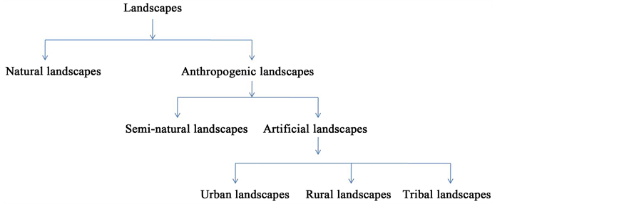
Figure 3. Classification of landscapes in the territory of Adilabad District, Deccan Region, India.
chemical and biological properties of soils found on anthropogenic landscapes are generally less favorable than those in soil found on natural landscapes [46] . For instance, urban soils are characterized by modified soil organism activity and modified soil temperature regimes, elevated soil reaction (pH), greater nutrient amounts and availability to plants, higher calcium levels, more rocks, greater decomposition rates, less accumulated organic matter, and compacted mixtures of anthropogenic materials compared with local remnants of the natural ecosystems [47] .
3.2.1. Natural Landscapes
In the study area, a higher dispersion for landscapes dominated by natural land cover was observed. All landforms and water components were assumed to be natural in the study area. Hills, valleys, forests, rivers, streams, waterfalls and lakes are dominant natural landscapes observed in the study area. Their natural patterns were generally site-specific and rather unique and rare. Natural landscape appears largely uncompromised by human modification and/or built elements and comprised of diverse natural systems that are functional and healthy. Natural landscapes are geosystems developed without mans contributions, which are often referred to as natural environments. Some natural landscapes, being free from human impact, represent a primeval natural system. A natural landscape can be best defined as an original landscape that exists before it is acted upon by human culture. However, in the twenty-first century landscapes that are totally untouched by human activity no longer exist, so that reference is sometimes now made to degrees of naturalness within a landscape. This type of landscape is in most cases unaffected or minimal influenced by human activity. The natural landscape is intact when all living and nonliving elements are free to move and change. As implied, a natural landscape may contain either the living or nonliving or even both. This landscape is a place which falls under the control of natural forces and free of the control of people for an extended period of time. First, we assumed that natural areas where human modification of land cover and human activities are minimal. Because perception and cognition of a landscape are not discrete events, landscape meaning may be more important than specific appearance in understanding peoples visual preferences for natural landscapes. On other grounds of acceptations there are opinions according to which the natural landscapes are in compliance with the initiatives of regeneration of urban areas [48] . Natural landscapes are those with little or no human impact [26] . Natural landscapes are highly valued and this is substantiated by psychophysical research on landscape value [49] [50] . The range of natural landscapes is shrinking rapidly, and the actual existence of such landscapes is a big question [25] .
In the context of conservation biology, the term natural is used to define anything that has not been made or influenced by humans, particularly by technology [51] [52] . In many situations, the human footprint may be difficult to recognize; thus, some authors tune the concept, accepting as natural a situation that is not measurably influenced by humans [53] . If we accept natural as being the antonym of artificial, the naturalness or the quality of being natural would express the level at which something occurs without artificial influence, a gradient ranking from the extreme of absolutely natural to the opposite, absolutely artificial. Humans are considered as a part of nature; therefore, all their activities should be taken as natural [54] . Conversely, humans are seen as a mix of biology and culture, and one should evaluate the condition of naturalness or artificialness according to which of each component is leading the activity. The word natural does not necessarily equate with the word pristine except in so far as landscape in a pristine state is probably rarer and of more value than landscape in a natural state. Often, when alluding to the pristine quality of a landscape, it refers to a landscape evolving under the auspices of its own ectogenetical code in which only the natural events can intervene. There is a spectrum of naturalness from pristine natural landscape to a cityscape, and a cultured landscape may still be an outstanding natural landscape. The word natural is a word indicating a product of nature and can include such things as pasture, exotic tree species, wildlife and many other things of that ilk as opposed to man-made structures, roads, railways and machinery. Ecosystems which are not influenced by man, or only indirectly, or only very extensively by hunters and gatherers may also be regarded as natural [55] [56] . Naturalness in forests means the co-occurrence of structural diversity of different stands offering a variety of niches, with species compositions belonging to all successional stages and cyclical phases. These conditions should exist at least partially and in some parts of a forest. It follows that naturalness can only be defined within a forested landscape, not within a single stand. Under naturalness we understand the actual expression of the natural state, as opposed to the cultural state (=state created by man) and the original state (=previous state in nature, uninfluenced by man) [57] . By contrast, the perception of naturalness is where landscapes appear largely uncompromised by modification and appear to comprise of natural systems that are functional and healthy. Naturalness describes the perception of the predominance of nature in the landscape. People may enjoy seeing a natural landscape because the landscape communicates the concept of naturalness. Naturalness is a concept which has no specific appearance in form, line, texture, or color. These formal visual qualities seem not to account for the power of naturalness as a predictor of visual preference. People prefer the visual quality of natural landscapes.
The diversity of geographic space, the socio-professional context encouraging a sense of transformation, the opportunities of current cultural acquisitions outline as many variants and variables through which the landscape space can be placed with easiness on a whole large scope of naturality. The naturalness of landscape places itself in a universal pattern, not critically differentiating from the word to the modelling act and vice versa. The small differences also range from rural to urban; even the rural inhabitants identify courageously with their landscape and end with the hues pinpointed by the researchers. The classic formula in representing the landscape stands valid: the components of physical origin, natural ones, give the tone to the conformation, organization, structure, functioning and visual legitimating of natural landscapes. The wild land context indicates a different interpretation of naturalness than does the rural context. A natural landscape can be perceived as wilderness because of certain key features, e.g., overwhelming scenery, the difficulty to access or the lack of signs of human civilization. There are aesthetic, moral and spiritual values connected to wilderness areas that are important experiences to humans apart from ecological values.
1) Hills and Valleys
Adilabad District is known for its characteristic presence of Sahyadri Hills locally called as Satnala Range in its northern boundary. The wooded hills and secluded valleys of Adilabad District are the habitats of the Kolams and the refuge area of some groups of Naikpods, where until the 1940s they practiced slash- and-burn cultivation with hoe and digging stick.
2) Forests
The forest area of the District is about 689517 ha and forms nearly 42.81% of the total area (Table 1). The entire District is covered by the tropical dry deciduous forests [30] . The forest has generally two stories or tiers of vegetations. The top storey consists mostly of Tectona grandis (Teak), Terminalia tomentosa (Nallamaddi), Pterocarpus marsupium (Bijasal), Anogeissus latifolia (Chirmanu), Madhuca latifolia (Mahua), Dalbergia latifolia (Jitregi), Strychnos nux-vo- mica (Musti) etc., and lower story consists of Phyllanthus emblica (Usiri), Aegle marmelos (Maredu), Butea monosperma (Modugu), Buchnania latifolia (Sarapappu), Bambusa spp. (Veduru), etc. [30] . The District is bestowed with dense Teak forests along the banks of river Godavari. These forests are home for several deciduous species like Teak (Tectona grandis), Nallamaddi (Terminalia tomentosa), Bijasal (Pterocarpus marsupium), Rosewood (Dalbergia latifolia), Narepa (Hardwickia binata), Veduru (Bambusa spp.), Bijasal (Pterocarpus marsupium), Chirmanu (Anogeissus latifolia), Mahua (Madhuca latifolia) and Musti (Strychnos nux-vomica) [58] . Except in Mudhole, erstwhile Taluk on the west, the forest is well distributed and the local population gets all its requirements of timber and fodder from the forests. Forests are natural or semi-natural areas. Forests are considered as a historically dominant part of our landscape [59] . Forests are natural landscapes [26] . Land use history has, more or less, reduced the naturalness of nearly all forests in the case study area. Natural forests are extremely rare in the case study area and restricted to a few areas. Most forests of natural origin are replaced today by diverse types of substitute plant communities. As a result, we encounter a mosaic of secondary forests, woodlands, grasslands and fields. While natural forests have decreased, reforestation, afforestation and social forestry activities have collectively been responsible for an increase in forested lands from 29.02% in 1955-1956 to 42.81% in 2015-16.
3) Rivers
Rivers are important natural waterways in the District. The most important river that traverses the District is the Godavari with Penganga, Wardha, Pranahita, Kadem and Peddavaagu as the tributaries and the rivulets flowing through are Satnala, Swarna and Suddavaagu [32] .
4) Streams
Streams are more than simply biodiversity; they are conduits for water and nutrients. Streams are freshwater habitats. Streamsides are linear habitat features. Streamsides are often relatively highly disturbed. Streamsides act as important refuges for species not favored in the modern intensively managed countryside and could be important for crop wild relatives diversity.
5) Lakes
Lakes are important natural water bodies in the District. Lakes are fresh water habitats. Lakes are natural landscapes [26] .
6) Waterfalls
The study area is bestowed with number of scenic waterfalls at various places. The important ones are Kuntala Water Falls and Pochara Water Falls. These waterfalls are beautiful landscapes with spectacular views not only of vital importance for tourism, but also for local people.
3.2.2. Anthropogenic Landscapes
The urge for survival has led humans to explore their surrounding natural environment for usable resources and cultivation. Humans consistently modify their environments-both directly and indirectly. This in turn has led humans to master the various uses of available natural resources, as well as to find the best ways of extracting them. The environmental impacts of human activities are irrational, violent, revolutionary or chaotic and pervasive. Over time, humans have gradually developed unique systems based on harmonious interactions with their natural environment. These sustainable systems have enhanced land management practices and made natural resource use more effective. These sociocultural systems and associated traditional ecological knowledge are forces that have, over centuries, shaped and formed unique landscapes adapted to various geographical and socio-cultural backgrounds around the world. Such sustainable human-in- fluenced landscapes, which have been known to be beneficial for biodiversity conservation and human well-being, are referred to here as anthropogenic landscapes. Anthropogenic complexes should be considered as new landscapes created by human and also all those natural complexes in which any of their components including vegetation with fauna had influenced by humans [60] . According to this definition every area in any place of earth can be considered as anthropogenic. Anthropogenic landscapes occur in most of the territories on the earth and the territory of Adilabad District is not an exception. For the purpose of this paper anthropogenic landscapes have been interpreted as the geographic products of interaction between human societies and culture with the natural environment. Anthropogenic landscapes are a vast group of heterogenic and heterotonic landscapes which include all forms of landscapes transformed by humans. Anthropogenic landscapes show characteristics that are determined by the action and interaction of human factors. An anthropogenic landscape is the most widely used term for modified natural landscapes in the result of the various degree of active anthropogenic impact on the structure and functions of natural complexes. Increased unsustainability occurs as a result of technicization all types of anthropogenic landscapes. This result from gradual increase in anthropogenic energy involved in the process of management and transformation of landscape.
1) Semi-Natural Landscapes
As soon as urban fringes retire, a matrix of cultivated land and pastureland predominate the appearance of the territory of the District. Amidst the mosaic of cultivated land and built environment, remnants and pockets of semi-natural vegetation and small biotopes sparsely scatter the landscape. Semi-natural landscapes can be regarded either as an evolutionary stage or a current stage of landscape which exists as a result of intentional protective measures of man. A semi- natural landscape is not something to be clearly defined or scrutinized, but it refers to landscapes which have been modified by human activity over long periods of time. Semi-natural landscapes are vast majority of natural landscapes which have been penetrated but not transformed by man throughout the history especially in the past 50 thousand years. An admixture between a variable content of natural and of artificial components makes up the dose of naturalness of landscapes, correctly called semi-natural. Semi-natural landscapes include both elements of natural components and outcomes of anthropogenic activity. Semi- natural landscapes contain a substantial number of elements and features significantly modified by human activities. They vary from grazed habitats to numerous cultural elements, such as traditional farmsteads and remnants of built environments. Semi-natural landscapes include agricultural and exotic land cover that has an absence of major infrastructure. Semi-natural landscapes are dominated by the majority of the natural areas of land cover change in the form of areas that are too small [27] .
Semi-natural landscapes may contain open and semi-open traditional rural biotypes and closed forest habitats, which form together with the surrounding habitats a complex landscape mosaic. Traditional rural biotypes are typical examples of biotypes created by traditional agricultural practices. They are hotspots of biodiversity in many semi-natural landscapes. Dramatic changes in agricultural practices especially during the last 50 years have threatened quantity and quality of traditional rural biotypes. As a consequence species dependent upon open and semi-open habitat conditions with traditional land use practices or management have declined. Nowadays many of the traditionally managed biotypes, such as grasslands, are overgrown and are often in a successional stage towards forests. Lack of management and sometimes dramatic changes in land uses have modified the structure of the landscapes and connections to historical and biological values and the character of the landscape has been lost. With the overgrowth of vegetation, valuable evidence of land use history is also disappearing. Remaining habitats and species of traditional rural biotypes are struggling in a strongly fragmented landscape, with extremely limited dispersal possibilities. Semi-natural landscapes may host variety of forest types. They vary from lately overgrown fields and pastures to relatively early over-grown fields and pastures forming nowadays old-growth forests. These patches together host species depending on certain successional state of forests (e.g. old deciduous forests) or other environmental process. Since semi-natural landscapes also host valuable natural elements such as relatively untouched forest patches, they maintain values related to both nature and culture. For such semi-natural landscapes, constant use or management is a prerequisite for their survival through time. Semi-natural landscapes are diverse management targets. In semi-natural landscapes, nature conservation activities include management of traditional rural biotypes, habitats of threatened species, broad leaved forests and herb-rich forests. Management of these features includes reactivation of ceased natural and cultural processes to maintain threatened characteristics of the biotypes.
2) Artificial/Cultural Landscapes
Artificial/cultural landscapes are nearly always created, formed, and structured by following artificial principles, i.e., principles which are not of natural nature, but of man who designs and constructs his world. In this respect, one can say that, ever since the 18th century, a central category of modernity has been the artificial. The physical structure of cities, towns, villages, homes and work places is called a built environment. It is the aggregate of the physical surroundings and conditions constructed by human beings (e.g. roads, railways, bridges and building structures), in contrast to those surroundings and conditions resulting from the natural environment.
Based on ecogeographic surveys, we classified artificial landscapes in the case study area into three main categories namely urban, rural and tribal landscapes located within urban, rural and tribal areas, respectively (Table 8). These landscapes reflect the dominant influences of human population on landscape character, often combining landform and land cover. A single artificial landscape has broadly similar patterns of human settlement, geology, landform, soils, vegetation, land use and field pattern in every area where it occurs. This does not mean that it will be identical, rather that there is a common pattern, which can be discerned. Economic activities of human population within classes of artificial landscapes proceed in several directions. As a result in each class of artificial landscape the certain structure of land use is organized. These diverse artificial
Table 8. Characterization and comparison of artificial landscapes in Adilabad District, Telangana, Deccan Region, India.
landscapes prove to be shaped not only by human hands, but by human minds as the socio-cultural, socio-cognitive specifics, both historical and contemporary, are major contributors to their multispecies make-ups, ecological processes and managerial actions. These diverse artificial landscapes are extremely different with respect to relief, function, human societies inhabiting them, degree of disturbance/human impact, transformation of landscape space and reduction of original natural patch types to a scattered pattern. Identification and explanation of these differences may contribute to a better understanding of the general biogeographical patterns in local territories. There is a dominance of man-made features, technicization, infrastructure development and industrial development in the case study area (Table 8). The linkage between human activity and artificial landscapes intensifies in urban situations. The lowest degree of disturbance occurs in tribal landscapes, followed by rural and urban landscapes. Urban landscapes are dominated by human habitats, while rural and tribal landscapes are dominated by plant habitats. Within urban towns, there is the cultivation of market gardens. The inhabitants of the rural communities are mainly farmers. The inhabitants of the tribal communities are mainly endogamous tribes. In the study area, urban, peri-urban and rural areas are the modern agricultural landscapes, while tribal areas are the traditional agricultural landscapes [32] .
(a) Urban Landscapes
In the District, there were 22 towns [7 Statutory Towns as Municipalities including 3 Urban Agglomerations (Adilabad, Mandamarri (New) and Mancherial) and 15 Census Towns] (Table 2). The term urban landscape refers to the more densely populated urban areas (cities and towns). Urban landscape includes all space having characteristics which are attributed to cities or towns. Urban areas form artificial landscapes [27] . The artificial landscapes and dense concentrations of human populations encountered in urban environments create a centripetal pull for resources that result in continual and distant landscape changes thus inextricably linking urbanism and anthropogenic landscapes. Examining past and present patterns of urban settlement and environmental impact provides context for this symbiotic relationship. Urban landscape is thought as a quilt. Urban landscapes are characterized by their relief plateaus. The urban landscape is a spatial matrix of landscape elements with different landscape functions. It consists of patches of forest, backyards, parking areas, abandoned lots, and buildings (houses, condominiums, hotels and malls) sewn together by streets, roads, highways, streams, and railway lines and utilities that support them. Across the District, towns are experiencing rapid urbanization, and with it, a growing demand for food, while at the same time facing ever increasing challenges in food production. There was accelerating urbanization District wide resulting in the loss of natural habitats and natural features, which are replaced directly by houses, condominiums, hotels, and malls, as well as by streets, highways and utilities that support them. According to landscape ecology, on the basis of human demand, urban landscape functions can be divided into four basic functions: biological production, environmental service, cultural support and information transportation. These functions are expressed in such corresponding landscape types as agricultural, ecological, residential and transportation. The heterogeneous matrix of landscape types and the correlation of landscape functions are the basis of the ecological integration of urban landscape. Compared to the District landscape, cultural support functions and information transportation functions of the urban landscape are higher, with lower functions of biological production and environmental services. The construction of urban areas and the development of road networks leave a significant signature on the earth’s surface, providing a geomorphological evidence to support the idea that humans are nowadays a geomorphic agent having deep effects on the morphological organization of the landscape [61] . Urban areas are inherently and strikingly heterogeneous, representing a mix of natural and built components at different densities and arrangements in the landscape [62] . Over the past decade, research in urban systems has increasingly focused on understanding the link between this spatial heterogeneity and ecological processes [45] [63] [64] .
Farm types were unconventional, partly mobile, partly without soil, more specialized independent units acting in cluster/chains. Farming was often a secondary livelihood and farmers often worked on a part time basis only. Some are beginners: urban citizens engaging in agriculture by necessity or by choice (entrepreneurs); others are recent migrants with weak traditional knowledge. Perishable products, especially green vegetables, dairy products, poultry and pigs, mushrooms, ornamental plants, herbs, fish etc. Cropping calendar was year-round growing of crops (irrigated). High land price, land scarcity, higher costs of labour, lower costs of commercial inputs, high cost of clean water, availability of low-cost organic wastes and wastewater were the common production factors. Farmer organizations were often lacking and cooperatives were more difficult to organize since farmers were dispersed and from greatly varied social backgrounds. Urban farmers often undertook activities outside their own neighborhood. The percentage of households engaged in farming in a neighborhood was highly variable, with urban farmers being highly variable in their socio-cultural backgrounds. The highly dynamic environment with strong fluctuations, the many external stakeholders with different interests and contrasting views on urban agriculture made the formal organization of farmers difficult. Research and extension services were minimally available, although individuals may gain direct access to libraries, research organizations, market information, etc. Credit services were barely available, but credit services for the informal sector were obtainable including for farmers and women. Proximity to markets, direct marketing to customers was possible and with a higher degree of local processing (including street foods). Land was insecure, often with informal use of public land and competitive land uses. It should be noted that converting agricultural land to build towns and to support the demands of growing urban populations itself drives other types of environmental change: urban dwellers depend on the productive and assimilative capacities of ecosystems well beyond their town boundaries (ecological footprint concept), to provide energy flows, material goods and non-material services that sustain human well-being and quality of life. Therefore, the landscape functions of the towns and District are united to support each other. Landscape functional planning in a single town cannot ensure the realization of urban sustainable development. Urban planning must be put in the context of the District, to realize the sustainable development of both the towns and the whole District through integrated District planning of urban landscape functions. Urban landscapes that have been transformed by urbanization, residential, commercial and industrial development, may help to conserve the integrity and ecological function of natural communities in remnant reserves.
(b) Rural Landscapes
In the District, there are 1725 Revenue Villages (Census Villages), of which 135 were uninhabited and 1590 were inhabited (Table 3). The term rural landscape refers to less densely populated villages and hamlets. A rural landscape includes a mosaic of different rural environments and habitats, and covers at least one to a few square kilometers. The term rural landscape describes the diverse portion of the District’s land area not densely populated or intensively developed, and not set aside for preservation in a natural state. A rural landscape is a spatial area constituting of several farms or small villages that are or have been inter-connected. The rural landscape includes a variety of geological and geographic features such as agricultural land, sheds and small rooms, farmhouses and farms amongst others. It supports the diversity of organisms that make human life possible in the District’s complex ecology. The rural landscape provides natural resources, food and fiber, wildlife habitat and inspiration. Rural landscapes are also characterized by their relief plateaus. Rural landscapes are artificial landscapes dominated by the majority of the natural areas of land cover change in the form of areas that are too small [27] . Agriculture represents the dominant rural land use in the District, and many species have adapted to rely on farmed habitats. Agricultural activities are more concentrated in rural areas. Agricultural landscapes that are one of the four elements of cultural landscape [65] are the main land use form, and the resulting high visibility leads to a widespread perception of rural farming. Rural landscapes are large areas of monoculture cropland, usually controlled by technologically advanced management systems. Rural landscapes were characterized by an agricultural system focusing upon intense production of one single food product. Districts rural landscapes are highly fragmented as a result of intensive agriculture. With the social context being the community, the economic interdependence between agriculture and wellbeing of the community is most pronounced in rural areas. Many traditional agricultural landscapes support large rural populations and have been farmed sustainably for thousands of years. Traditional rural landscapes are fundamental for the conservation of biodiversity [66] [67] . Rural landscapes can also support in-situ conservation of crop varieties and wild species that are necessary for sustainable agricultural production and rural livelihoods. The heterogeneous, mosaic structure of the traditional rural landscape is another reason suggested to explain why so many species could survive in the agro-ecosystem. Most of the District’s poor people live in rural landscapes, and are especially vulnerable to the ecological and economic risks associated with such transitions.
In the rural landscapes, most families were engaged in farming as was expected and shared a common social background, more homogeneous, relatively stable, with few external stakeholders; and farmers were more organized. Conventional farms consisting of interdependent subunits (fields) were common. Farming was the primary livelihood in rural landscapes with farmers being the managers of the rural environment. They were engaged full-time; usually born into a farming family with strong traditional knowledge. Mainly staple and cash crops were cultivated along with rearing of livestock. Cattle, buffalo, goat and sheep, mainly nondescript, constituted the livestock population, which was sparse, concentrated to a few farms, and mainly kept indoors. Animal husbandry was only second to agriculture in terms of contributing to the gross income and employment in the District. Cropping calendar was of seasonal periods. Low land price, lower costs of labour, high costs of commercial inputs, variable cost of water were common production factors. Land security was relatively high. Farmer organizations were often already in place and more easy to organize since farmers shared the same social background. From environmental point of view, rural landscapes were relatively stable, and land and water resources were rarely polluted. Availability of research and extension services was more although declining due to migration of people to towns. Availability of credit services was more likely especially for progressive farmers or those with large farm holdings and mainly men. Markets were distant and market chains were prevalent. The importance of recognizing multifunctional processes and products of rural landscapes has grown in recent years [68] . This is due in part to greater attention to systems dimensions of agriculture and food production, including emergent properties at scales larger than fields or farms. What is important is how the structure of these managed rural landscapes influences their function, both for immediate economic returns to owners and the ecosystem services that are provided for the wider society. Changing society always brings developmental issues such as highway construction, large scale supermarkets and factories expansion to a rural area. Rural landscapes are, by their nature, strongly influenced by the type of rural activity and the intensity of associated settlements. Natural elements generally remain strongly evident but are overlaid by patterns and processes of human activity. Natural systems operate but, in places, are manipulated to enhance productivity. Human induced patterns and processes are related predominately to productive land uses such as agriculture, horticulture and forestry, typically including paddocks, shelter belts, woodlots and forest blocks, cropping regimes and settlement. In rural landscapes of the District, vegetable garden plots, arable crop fields, ponds, rice fields, pasturelands or forest fragments were found at various distances from human settlements. The rural landscape of the case study area is an interweaving of agricultural, forestry, and rural residential land uses reflecting the history of both natural processes and human settlement. In rural landscapes of the study area, recent increases in agricultural productivity can largely be attributed to dependence on high-yield- ing varieties, irrigation, and agrochemical inputs, yet many of the inputs and practices of intensive agriculture are detrimental to human health, environmental quality, and the maintenance of biodiversity. Thus, in this type of heterogeneous rural landscapes, the best management option for achieving reasonable values of agricultural production and for biodiversity conservation involve the application of localized intensive agriculture on croplands while retaining relatively small remnants of natural or semi-natural vegetation. Controlled expansion of agricultural areas without replacement of natural vegetation in these heterogeneous rural landscapes, involves a reasonable degree of agricultural production and maintenance of optimal conditions for conservation of biodiversity and agrobiodiversity. Traditional rural landscapes are fundamental for the conservation of biodiversity. Rural residential development has the potential to affect resource lands by occupying productive areas and interacting with farm and forestry practices. Further, such development has the potential to present special challenges to urban expansions: punctuating open space and natural areas with expansion of roads and infrastructure, bringing traffic, noise, air, water, and light pollution. The patterns and locations of future rural development can thus affect both rural and urban residents of the District. The patterns of human activity are generally large scale by comparison with urban areas, reflected in generally low-density settlement, few structures and often a sense of spaciousness.
(c) Tribal Landscapes
Adilabad is predominantly inhabited by Aadivasi forest dwellers which include several indigenous tribal groups Gond, Naikpod, Kolam, Pardhan, Koya, Manne, Andh, Thoti, Lambada and Yerukala spread over 650 Revenue Villages with Utnoor as the headquarters for Integrated Tribal Development Agency (ITDA) [33] . These tribal communities have been existed since centuries and have a strong social, historical and cultural back ground. The Naikpods lived in hill settlements. The wooded hills and secluded valleys of Adilabad District were the habitats of the Kolams. The term tribal landscape refers to more remote, isolated and thinly populated tribal villages and hamlets (Tandas). Tribal landscapes are characterized by their hills and valleys as relief. The highlands of Adilabad are one of the areas with a higher proportion of tribal population as compared with the rest of the State. Tribal landscape is defined as any place in which a relationship, past or present, exists between a spatial area, resource, and an associated group of indigenous tribal people whose cultural practices, beliefs or identity connects them to that place. Tribal landscapes include areas where there is little or no human impact. Tribal landscapes (forest landscapes) are forest production complexes and Adilabad is known for its significant forests. Tribal landscapes are natural landscapes and consist of a mixture of forests, ploughed fields, grasslands and villages. There always exists a symbiotic relationship between their livelihood pursuits and the surrounding natural resource base such as the forest, land, water bodies, mineral resources and other flora and fauna in tribal landscapes [32] . For tribal people, land and forests are the important natural resources and are employed for different purposes. Apart from the land, which is the only tangible asset and important source of livelihood, forests are the second source of revenue as they collect various minor forest products for their regular income [32] . Open access of land has always been the basis of the tribal economy in the study area. The cultivation of land is the main economic activity of the tribes. Historically, along with collection of forest resources, the hunter gatherers or tribal societies have been practicing marginal and subsistence agriculture [32] [69] . In Adilabad, tribal landscapes are totally rainfed agro-ecosystems with the economy being primarily agro-based [32] . Agriculture is the main source of livelihood for almost 90% of tribal households. The tribal landscapes are typically but not always managed by smallholders and indigenous tribal farmers with backyard farming also prevalent [33] . On the basis of topography, agroecology and their racial and cultural backgrounds, tribes have adopted diverse, sometimes area and community specific, agricultural practices with their time tested indigenous knowledge and technologies, and have integrated several related world view (spiritual) practices. The study revealed that the indigenous tribal communities in the past had evolved and adopted several mechanisms for land, soil and crop management including natural pest management in the tribal landscapes. In the tribal landscapes of the study area, rice fields are located in secluded valleys along rivers, and crop fields and settlements are located on the terraces and secondary woodlands of surrounding hills. Until the 1940s, Naikpods practiced slash-and-burn cultivation with hoe and digging stick. Traditionally they utilize plain forest land for cultivation and follow shifting cultivation. But with time and external influence, the practices have changed, firstly the shift from sustenance-agriculture practices to input intensive agriculture with use of pesticide and fertilizer; and secondly the shift from a primarily food-based system of cropping to commercial cash crops. They keep changing the patch of land every two to three years. The farmlands have dry, arid, black and loamy soil, which is best suited for growing millets and pulses. In the tribal landscape, silvicultural lands are embedded with small plots where market oriented, cash cropping of cotton, corn and sorghum is practiced. Several farmers maintained tracts of secondary vegetation on their lands. Even with all these potential elements, the major disturbances which ensued in the tribal landscapes in the last few decades have affected all of the economic and social life components: economic relations, system of values, individual behavior, the basic elements of tribal community life. In these conditions, tribal landscapes have experienced a regressive process. Indigenous tribal communities that use traditional resource management practices and knowledge have achieved a great deal for the global community by developing and caring for a broad base of agrobiodiversity. Local people in tribal settings have retained their traditional land-use practices, which are based on forest resources. Forested landscapes are of indisputably high importance for the tribal people living in the presented research area. Traditional tribal agricultural landscapes form part of the cultural and natural heritage; the ecological integrity and the scenic value of landscapes make tribal areas attractive for the establishment of diverse enterprises, for places to live, for tourism, and recreation businesses. It is possible to develop ecological, scientifically-in- formative and partially recreational and sanitary (health-improving) tourism along with elements of agricultural tourism in these tribal territories. Although some of the components may stay unchanged, much of aesthetic, historical or cultural value of tribal landscapes remains to be inventoried and recorded urgently before it completely disappears.
4. Conclusions
The results revealed a distinctive land use pattern dominated by forests contributing to amenity and the quality of the environment in Adilabad District, Telangana, Deccan Region, India. Over the last 60 years, a very wide range of land use changes was observed in the territory and District landscape was highly transformed and fragmented as a result of human activities such as deforestation, agriculture expansion, intensive agriculture, transport infrastructure, urbanization, trade, tourism and recreation. Study of the land use changes in the District enable us to propose possible future situations based on the design and implementation of management policies that consider the history of changes occurred. Thus, it permits careful future development and planning strategies to mitigate potential negative environmental impacts while still gaining the benefits of mixed land uses. There is a growing body of evidence supporting the hypothesis that the geographical space in Adilabad District is limited, being a mosaic of natural and anthropogenic landscapes (semi-natural landscapes and artificial landscapes). These categories are overlapping and interconnected and may not always have distinct boundaries. This landscape classification was for the purpose of understanding the natural diversity of the District as a basis for planning and managing ecology which is equally valid for landscape planning. Our study identifies the same importance to all types of landscapes; thus natural, semi- natural, tribal, rural and urban landscapes are the key factors in cultural identity of the case study area. Our work on landscape analysis as a tool for the strategic assessment of the case study area enabled us to use visual-based approach based on the assessment of the visual fields of the case study area.
In the study area, we found certain natural landscapes with little or no human impact like hills, valleys, forests, rivers, streams, waterfalls and lakes. We focused on natural landscapes, which are an outcome and excellent indicator of environmental conditions and historical biogeographical processes, but nevertheless do not take into account the full ecological and biogeographical complexity of landscapes. Our results offer a preliminary basis for understanding patterns of broad-scale landscape diversity of natural ecosystems and provide the first preliminary classification relevant to local-scale conservation initiatives. Our results enable the identification of three broad categories of artificial landscapes namely urban, rural and tribal landscapes, which merit more dedicated focus in local and District planning, each with slightly different management objectives. These are landscapes that are co-constructed by multiple species through complex webs of ecologies, economies and histories and represent the way that humans are drawn into relationships with non-humans; relationships which in turn alter landscapes in the study area. These diverse anthropogenic landscapes might have co-evolved with human societies inhabiting them and offer living models of sustainable land and resource use practices. The diverse anthropogenic landscapes presented in this study are the first attempt to provide a traditional classification of the landscapes based on the distribution of urban, rural and tribal populations in the case study area. However, it is important to recognize that these anthropogenic landscapes are often working environments undergoing change and used for a variety of purposes. This classification is a source for detection of fragmentation of landscape structure and forms a basis for the balanced organization of the territory in the District. Although farming activities are not restricted to rural landscapes, the economic interdependence between agriculture and community wellbeing is most pronounced in rural landscapes. As agriculture dominates and shapes the landscape in rural and tribal regions, the contribution made by this strategy is also of particular relevance in efforts towards achieving sustainable rural and tribal development. Tribal landscapes are managed and domesticated by indigenous tribal communities in various degrees, rather than a pristine and untouched forest. Transformation of rural and/or tribal to urban ecosystems is an expression of changed livelihoods that modify the landscape and its cultural values and often degrade cultural heritages. Thus, the classification and characterization of natural and anthropogenic complexes provide data to increase our understanding of the structure of landscapes. These data can be used in landscape planning to define certain options for sustainable development of the localities within each type of anthropogenic landscape.
This study provides a starting point for designing conservation initiatives that respond to each particular anthropogenic landscape and aim at a context-based sustainability. Although a landscape approach to agricultural research could provide information on the design of agroecosystems to maximize synergies, enhance resilience and inform what policies would be useful in influencing collective actions, programs to encourage such research do not exist. The use of Geographic Information Systems (GIS) technology will be essential for the examination of landscape and regional-level questions. Understanding, predicting and adjusting to changing landscapes increasingly altered by humans constitute pressing challenges that fall squarely within the purview of earth surface science. Mechanistic models that account explicitly for human-landscape interactions are needed, especially for adaptive management and for assisting decision making in the face of change. Science is far from developing a general theory of human- nature systems, even though such a theory may offer the potential to slow or reverse environmental degradation. Because such a theory would include knowledge of societal perceptions of environmental impacts and the ability and willingness of societies to react to these changes, much focused inductive and empirical work is still required to investigate these interacting processes in a range of earth surface environments and human societies. It is envisaged that the landscape classification will be further enhanced with landscape value information based on robust public preference studies (psycho-physical approach) that assesses the quality of different landscapes. Evidently, the paper could only briefly touch upon the vast and complex issues involved in this topic. Accordingly, it should rather be considered as an attempt to give a broad overview of the natural and anthropogenic landscapes in the District and the associated challenges. Hence, each of the issues tackled above calls for a more profound approach and a further deepening of research.
Acknowledgements
This study would never be completed without the contribution of many people to whom we would like to express our gratitude. The administrative Adilabad’s development agents, district agricultural officials, local guides, committee leaders and respondent households in each of the sampling areas were indispensable for the successful completion of the field work. We would like also to acknowledge people who contributed their knowledge and time in data collection and entry processes. This manuscript is dedicated to esteemed Horticulturists Gayam Sandhya Rani and Linga Swathi. The senior author is most thankful for their inspiration and enthusiasm and wants to highlight their contribution, constant support and dedication to ecology, nature conservation and horticulture.
Cite this paper
Reddy, M.T., Pandravada, S.R., Sivaraj, N., Kamala, V., Sunil, N. and Dikshit, N. (2017) Classification and Characterization of Landscapes in the Territory of Adilabad District, Telangana, Deccan Region, India. Open Access Library Journal, 4: e3745. https://doi.org/10.4236/oalib.1103745
References
- 1. Bogaert, J., Vranken, I. and Andre, M. (2014) Anthropogenic Effects in Landscapes: Historical Context and Spatial Pattern. In: Hong, S.K., Bogaert, J. and Min, Q., Eds., Biocultural Landscapes: Diversity, Functions and Values, Springer Science + Business Media, Dordrecht, 89-112.
https://doi.org/10.1007/978-94-017-8941-7_8 - 2. Council of Europe (2000) European Landscape Convention, Council of Europe, Strasbourg. EC, 2012. European Commission, Agricultural and Rural Development, Brussels.
- 3. Cary, J. (2000) The Aesthetics of Remnant Vegetation and Rural Landscape Features. In: Hamblin, A., Ed., Visions of Future Landscapes, Proceedings of the Australian Academy of Science Fenner Conference on the Environment, Canberra, 2-5 May 1999, Bureau of Rural Sciences, Canberra, 103-108.
- 4. Richling, A. and Lewandowski, W. (1988) The Map of Landscape Use. Miscellanea Geographica, Wazszawa.
- 5. Kolyka, L. and Lipsky, Z. (1999) Maps of Present Landscape. Geographie (Geography) Journal of the Czech Geographical Society, 104, 161-175. (In Czech)
- 6. Yang, J., Jiang, Z., Zeng, Y., Turghan, M., Fang, H. and Li, C. (2011) Effect of Anthropogenic Landscape Features on Population Genetic Differentiation of Przewalski’s Gazelle: Main Role of Human Settlement. PLoS ONE, 6, e20144.
https://doi.org/10.1371/journal.pone.0020144 - 7. Fuentes, A. and Baynes-Rock, M. (2017) Anthropogenic Landscapes, Human Action and the Process of Co-Construction with Other Species: Making Anthromes in the Anthropocene. Land, 6, 15.
https://doi.org/10.3390/land6010015 - 8. Hooke, R. and Martin-Duque, L.B.J.F. (2012) Land Transformation by Humans: A Review. GSA Today, 22, 4-10.
https://doi.org/10.1130/GSAT151A.1 - 9. Ellis, E.C., Kaplan, J.O., Fuller, D.Q., Vavrus, S.J., Goldewijk, K.K. and Verburg, P.H. (2013) Used Planet: A Global History. Proceedings of the National Academy of Sciences USA, 110, 7978-7985.
https://doi.org/10.1073/pnas.1217241110 - 10. Steffen, W., Grinevald, J., Crutzen, P. and McNeil, J. (2011) The Anthropocene: Conceptual and Historical Perspectives. Philosophical Transactions of Royal Society A, 369, 842-867.
https://doi.org/10.1098/rsta.2010.0327 - 11. Ellis, E.C. and Ramankutty, N. (2008) Putting People in the Map: Anthropogenic Biomes of the World. Frontiers in Ecology and the Environment, 6, 439-447.
https://doi.org/10.1890/070062 - 12. McIntyre, S. and Hobbs, R.J. (1999) A Framework for Conceptualizing Human Effects on Landscapes and Its Relevance to Management and Research Models. Conservation Biology, 13, 1282-1292.
https://doi.org/10.1046/j.1523-1739.1999.97509.x - 13. Fischer, J. and Lindenmayer, D.B. (2007) Landscape Modification and Habitat Fragmentation: A Synthesis. Global Ecology and Biogeography, 16, 265-280.
https://doi.org/10.1111/j.1466-8238.2007.00287.x - 14. Hamilton, C. and Grinevald, J. (2015) Was the Anthropocene Anticipated? The Anthropocene Review, 2, 59-72.
https://doi.org/10.1177/2053019614567155 - 15. Ellis, E.C. (2015) Ecology in an Anthropogenic Biosphere. Ecological Monographs, 85, 287-331.
https://doi.org/10.1890/14-2274.1 - 16. Bridgewater, P.B. and Arico, S. (2002) Conserving and Managing Biodiversity Sustainability: The Roles of Science and Society. Natural Resources Forum, 26, 245-248.
https://doi.org/10.1111/0165-0203.00025 - 17. Defries, R.S., Foley, J.A. and Anser, G.P. (2004) Land-Use Choices: Balancing Human Needs and Ecosystem Function. Frontiers in Ecology and the Environment, 2, 249-257.
https://doi.org/10.1890/1540-9295(2004)002[0249:LCBHNA]2.0.CO;2 - 18. Perrings, C., Barbier, E.B., Brown, G., Dalmazzone, S., Folke, C., Gadgil, M., Hanley, N., Holling, C.S., Maler, K.G., Mason, P., Panayotou, T. and Turner, R.K. (1995) The Economic Value of Biodiversity. In: Heywood, V. and Watson, R., Eds., Global Biodiversity Assessment, Cambridge University Press, Cambridge, 823-914.
- 19. Pascual, U. and Perrings, C.P. (2007) The Economics of Biodiversity Loss in Agricultural Landscapes. Agriculture, Ecosystems and Environment, 121, 256-268.
https://doi.org/10.1016/j.agee.2006.12.025 - 20. Theobald, D.M., Reed, S.E., Fields, K. and Soule, M. (2012) Connecting Natural Landscapes Using a Landscape Permeability Model to Prioritize Conservation Activities in the United States. Conservation Letters, 5, 123-133.
https://doi.org/10.1111/j.1755-263X.2011.00218.x - 21. Daily, G.C. (2001) Ecological Forecasts. Nature, 411, 245.
https://doi.org/10.1038/35077178 - 22. Urquiza-Haas, T., Dolman, P.M. and Peres, C.A. (2007) Regional Scale Variation in Forest Structure and Biomass in the Yucatan Peninsula, Mexico: Effects of Forest Disturbance. Forest Ecology and Management, 247, 80-90.
https://doi.org/10.1016/j.foreco.2007.04.015 - 23. Gardner, T.A., Barlow, J., Chazdon, R., Ewers, R.M., Harvey, C.A., Peres, C.A. and Sodhi, N.S. (2009) Prospects for Tropical Forest Biodiversity in a Human-Modified World. Ecology Letters, 12, 561-582.
https://doi.org/10.1111/j.1461-0248.2009.01294.x - 24. Atik, M. (2009) Avrupa Birliginde Doganin Korunmasive Natura 2000, Turkiyeve Orta Dogu Amme Idaresi Enstitusu Yayini, No: 354, Yerel Yonetimler Merkeziyayini No: 27. Sayfa, Ankara, 119-134.
- 25. Myga-Piatek, U. (2014) Natural, Anthropogenic and Cultural Landscapes an Attempt to Define Mutual Relations. Prace Komisji Krajobrazu Kulturowego. Dissertations of Cultural Lnadscape Commission, Sonsoweic, 39-56.
- 26. Cepel, N. (1990) Ekolojik Terimler Sozlugu. Istanbul Universitesi Orman Fakultesi Yayinlari, Istanbul, 3048.
- 27. Eroglu, E., Acar, C. and Turna, I. (2013) Homegardens in Landscape Architecture—A Case Study of Hazelnut Plantations. In: Ozyavuz, M., Ed., Advances in Landscape Architecture. InTech, Croatia, 761-772.
- 28. Hijmans, R.J., Guarino, G. and Macathur, P. (2012) DIVA-GIS. Version 7.5.0. Manual.
http://www.divagis.org - 29. Nayar, M.P., Singh, A.K. and Nair, K.N. (2009) Agrobiodiversity Hotspots in India: Conservation and Benefit Sharing, Volume I & II. PPV & FR Authority, New Delhi, 217 -307.
- 30. Census of India (2011a) Andhra Pradesh, Series-29, Part Xii-A, District Census Handbook Village and Town Directory, Directorate of Census Operations. Kendriya Sadan, Sultan Bazar, Ministry of Home Affairs, Hyderabad, 1344.
- 31. Pandravada, S.R., Sivaraj, N., Sunil, N., Jairam, R., Prasanthi, Y., Chakrabarty, S.K., Ramesh, P., Bisht, I.S and Pareek, S.K. (2013) Sorghum Landraces Patronized by Tribal Communities in Adilabad District, Andhra Pradesh. Indian Journal of Traditional Knowledge, 12, 465-471.
- 32. Reddy, M.T., Pandravada, S.R., Sivaraj, N., Sunil, N., Dikshit, N. and Kamala, V. (2017) Backyard Farming of Okra (Abelmoschuses culentus L. Moench) in Traditional Agricultural Landscapes of Adilabad District, Telangana, India. Journal of Global Agriculture and Ecology, 6, 147-161.
- 33. Kumar, K.A. (2010) Local Knowledge and Agricultural sustainability: A Case Study of Pradhan Tribe in Adilabad District. Working Paper No. 81. Centre for Economic and Social Studies, Begumpet, Hyderabad, 36.
- 34. Pandravada, S.R., Sivaraj, N., Sunil, N., Jairam, R., Chakrabarty, S.K., Ramesh, P., Jadhav, S.N., Bisht, I.S. and Bansal, K.C. (2012) NAIP Brochure on Adilabad, Andhra Pradesh. National Bureau of Plant Genetic Resources, Regional Station, Rajendranagar, Hyderabad, 1-4.
- 35. Gueroui, D., Baha-Eddine, B. and Djamel, F. (2017) Landscape Approaches as a Strategic Tool in the Environmental Management of Resources and Territories: Case of Ain Dalia Dam in Northeastern Algeria. International Journal of Advanced Engineering and Management, 2, 118-126.
https://doi.org/10.24999/IJOAEM/02050030 - 36. European Environmental Agency (2005) The European Environment-State and Outlook 2005. Luxembourg, Copenhagen, 570.
- 37. Hunziker, M. (1995) The Spontaneous Reforestation in Abandoned Agricultural Lands: Perception and Aesthetic Assessment by Locals and Tourists. Landscape and Urban Planning, 31, 399-410.
https://doi.org/10.1016/0169-2046(95)93251-J - 38. Franco, D., Mannino, F.I and Zanetto, G. (2003) The Impact of Agroforestry Networks on Scenic Beauty Estimation. The Role of a Landscape Ecological Network on a Socio-Cultural Process. Landscape and Urban Planning, 62, 119-138.
https://doi.org/10.1016/S0169-2046(02)00127-5 - 39. Fadel, D., Donadieu, P. and Kholladi, M.K. (2010) Estimation des potentialitespaysageresd’unecarrieredans le nord-estalgerien en vue de son integration dans le paysageenvironnant. Revue Sciences and Technologie (D), 32, 27-32.
- 40. Census of India (2011b) Andhra Pradesh, Series-29, Part Xii-B, District Census Handbook Village and Town Wise Primary Census Abstract (PCA). Kendriya Sadan, Sultan Bazar, Ministry of Home Affairs, Hyderabad, 515.
- 41. Haimendorf, C.V.F. (1988) Tribes of India (Struggle for Survival). Oxford University Press, Oxford, 57.
- 42. Lososova, Z., Chytry, M., Kuhn, I., Hajek, O., Horakova, V., Pysek, P. and Tichy, L. (2006) Patterns of Plant Traits in Annual Vegetation of Man-Made Habitats in Central Europe. Perspectives in Plant Ecology, Evolution and Systematics, 8, 69-81.
https://doi.org/10.1016/j.ppees.2006.07.001 - 43. Lundholm, J.T. and Richardson, P.J. (2010) Habitat Analogues for Reconciliation Ecology in Urban and Industrial Environments. Journal of Applied Ecology, 47, 966-975.
https://doi.org/10.1111/j.1365-2664.2010.01857.x - 44. Gokalp, D.D. and Yazgan, E.M. (2013) Kirsal Peyzaj Planlamada Agroturizmve Agriturizm. KMU Sosyalve Ekonomik Arastirmalar Dergisi, 15, 25-29.
- 45. Pickett, S.T.A., Cadenasso, M.L., Grove, J.M., Nilon, C.H., Pouyat, R.V., Zipperer, W.C. and Costanza, R. (2001) Urban Ecological Systems: Linking Terrestrial Ecological, Physical, and Socioeconomic Components of Metropolitan Areas. Annual Review of Ecology, Evolution and Systematics, 32,127-157.
https://doi.org/10.1146/annurev.ecolsys.32.081501.114012 - 46. Rewicz, A., Kolodziejek, J. and Jakubska-Busse, A. (2016) The Role of Anthropogenic Habitats as Substitutes for Natural Habitats: A Case Study on Epipactis helleborine (L.) Crantz (Orchidaceae, Neottieae). Variations in Size and Nutrient Composition of Seeds. Turkish Journal of Botany, 40, 258-268.
https://doi.org/10.3906/bot-1404-69 - 47. McDonnell, M.J., Pickett, S.T.A., Groffman, P., Bohlen, P., Pouyat, R.V., Zipperer, W.C., Parmelee, R.W., Carreiro, M.M. and Medley, K. (1997) Ecosystem Processes along an Urban-to-Rural Gradient. Urban Ecosystems, 1, 21-36.
https://doi.org/10.1023/A:1014359024275 - 48. Grandin-Maurin, C., Giorgiutti, V. and Bunuel, F. (2003) Passions et raisons du paysage—Une nature sensible, Collection Jardins et Paysages, Les Editions de l_Imprimeur.
- 49. Environment Waikato (2003) Coastal Values and Beach Use Survey Report. Technical Report No 2003/9. Hamilton, New Zealand.
- 50. Fairweather, J.R. and Swaffield, S.R. (1999) Public Perceptions of Natural and Modified Landscapes of the Coromandel Peninsula, New Zealand. Research Report No. 241. Agribusiness and Economics Research Unit, Lincoln University, Canterbury.
- 51. Hunter Jr., M.L. (1996) Benchmarks for Managing Ecosystems: Are Human Activities Natural. Conservation Biology, 10, 695-697.
https://doi.org/10.1046/j.1523-1739.1996.10030695.x - 52. Angermeier, P.L. (2000) The Natural Imperative for Biological Conservation. Conservation Biology, 14, 373-381.
https://doi.org/10.1046/j.1523-1739.2000.98362.x - 53. Freedman, B. (1989) Environmental Ecology. The Impacts of Pollution and Other Stresses on Ecosystem Structure and Function. Academic Press, San Diego.
- 54. Comer, P.J. (1997) A Natural Benchmark for Ecosystem Function. Conservation Biology, 11, 301-303.
- 55. Erz, W. (1992) UngestorteNatur-Grundsatzuberlegungen, Wid-erspruche, Klarungen und Konsequenzen. WWF Tagungsbericht Husum, 6, 55-83.
- 56. Bergstedt, J. (1997) Theorie des Naturschutzes. In: Handbuch An-gewandter Biotopschutz II-3,10, Erg. Lfg.,10/97 S, Ecomed Verlag, Landsberg, 3-10.
- 57. Scherzinger, W. (1996) Naturschutz im Wald: Qualitatsziele einer dyna-mischen Waldentwicklung. Zoosystematics and Evolution, 74, 149.
- 58. Socioeconomic Outlook (2015) Reinventing Telangana—The First Steps. Planning Department, Government of Telangana, Hyderabad, 190.
- 59. Vispo, C. (2014) The Nature of the Place. Adonis Press, New York, 361.
- 60. Milkov, F.N. (1973) Human and Landscapes, Musl, Moscow. In: Gamble, J.S. and Fischer, C.E.C., Eds., Flora Presidency of Madras, (Reprinted 1957, Calcutta). Moresdale, London, 223. (In Russian)
- 61. Sofia, G. and Tarolli, P. (2015) Geomorphology of Anthropogenic Landscapes. Geophysical Research Abstracts, 17, EGU 2015-3372, EGU General Assembly 2015.
- 62. Zhou, W., Cadenasso, M.L., Schwarz, K. and Pickett, S.T.A. (2014) Quantifying Spatial Heterogeneity in Urban Landscapes: Integrating Visual Interpretation and Object-Based Classification. Remote Sensing, 6, 3369-3386.
https://doi.org/10.3390/rs6043369 - 63. Grimm, N.B., Grove, J.M., Pickett, S.T.A. and Redman, C.L. (2000) Integrated Approaches to Long-Term Studies of Urban Ecological Systems. Bioscience, 50, 571-584.
https://doi.org/10.1641/0006-3568(2000)050[0571:IATLTO]2.0.CO;2 - 64. Pickett, S.T.A., Cadenasso, M.L., Grove, J.M., Boone, C.G., Groffman, P.M., Irwin, E., Kaushal, S.S., Marshall, V., McGrath, B.P., Nilon, C.H., Pouyat, R.V., Szlavecz, K., Troy, A. and Warren P. (2011) Urban Ecological Systems: Scientific Foundations and a Decade of Progress. Journal of Environmental Management, 92, 331-362.
https://doi.org/10.1016/j.jenvman.2010.08.022 - 65. Karahan, F. and Orhan, T. (2008) Uzundere Vadisi Tarimsal Faalietlerinin PeyzajCesitliligine Etkileri. Alinteri, 15, 26-32.
- 66. Antrop, M. (2005) Why Landscapes of the Past Are Important for the Future. Landscape and Urban Planning, 70, 21-34.
https://doi.org/10.1016/j.landurbplan.2003.10.002 - 67. Calvo-Iglesias, M.S., Fra-Paleo, U. and Diaz-Varela, R.A. (2009) Changing in Farming System and Population as Drivers of Land Cover and Landscape Dynamics: The Case of Enclosed and Semi-Open Field Systems in Northern Galicia (Spain). Landscape and Urban Planning, 90, 168-177.
https://doi.org/10.1016/j.landurbplan.2008.10.025 - 68. Brandt, J., Tress, B. and Tress, G. (2000) Multifunctional Landscapes: Interdisciplinary Approaches to Landscape Research and Management. Proceedings of International Conference Centre for Landscape Research, Univ. Roskilde, Denmark, 18-21 October.
- 69. Kala, C.P. (2013) Traditional Ecological Knowledge on Characteristics, Conservation and Management of Soil in Tribal Communities of Pachmarhi Biosphere Reserve, India. Journal of Soil Science and Plant Nutrition, 13, 201-214.