International Journal of Geosciences
Vol.5 No.3(2014), Article ID:44230,11 pages DOI:10.4236/ijg.2014.53031
An Interpretation of Structures from the Aeromagnetic Field over a Region in the Nigerian Younger Granite Province
J. Raimi1, B. B. M. Dewu2, P. Sule1
1Department of Physics, Ahmadu Bello University (ABU), Zaria, Nigeria
2Centre for Energy Research and Training, Zaria, Nigeria
Email: raimi.jimoh@yahoo.com, bbmdewu@yahoo.com, psule@yahoo.com
Copyright © 2014 by authors and Scientific Research Publishing Inc.
This work is licensed under the Creative Commons Attribution International License (CC BY).
http://creativecommons.org/licenses/by/4.0/


Received 24 December 2013; revised 23 January 2014; accepted 22 February 2014
ABSTRACT
An interpretation of high resolution aeromagnetic data was carried out to provide new information about the study area. Located between latitude 10˚30'N and 11˚00'N and longitude 8˚30'E and 9˚00'E, the interpretation revealed previously unknown folds and magnetic anomaly with a signature that is similar to those associated with ring complexes in the study area but without the surface manifestation that is associated with the complexes. Qualitatively interpreted as unexposed ring complex, the magnetic anomaly is underlain by cross-over of major lineaments; implying presence of weak zone that probably allowed the volcanic eruption that initiated the emplacement of the source of the anomaly. A depth that ranges from outcrop to 1200 m and from outcrop to 1800 m is respectively suggested for the unexposed ring complex and folds by the Euler deconvolution results.
Keywords:Aeromagnetic; Euler Deconvolution; Ring Complex; Lineaments; Folds

1. Introduction
Several geological and geochemical studies have been carried out in a study area that is bounded by latitude 10˚30'N and 11˚00'N and longitude 8˚30'E and 9˚00'E [1] -[5] . Situated within the Nigerian younger granite province (Figures 1 and 2), the studies were mainly carried out because of the economic importance of some of the ring complexes in the area. The earliest gravity surveys were used to delineate and provide information about the ring complexes [6] -[10] . However, the studies have failed to provide information on structural setting
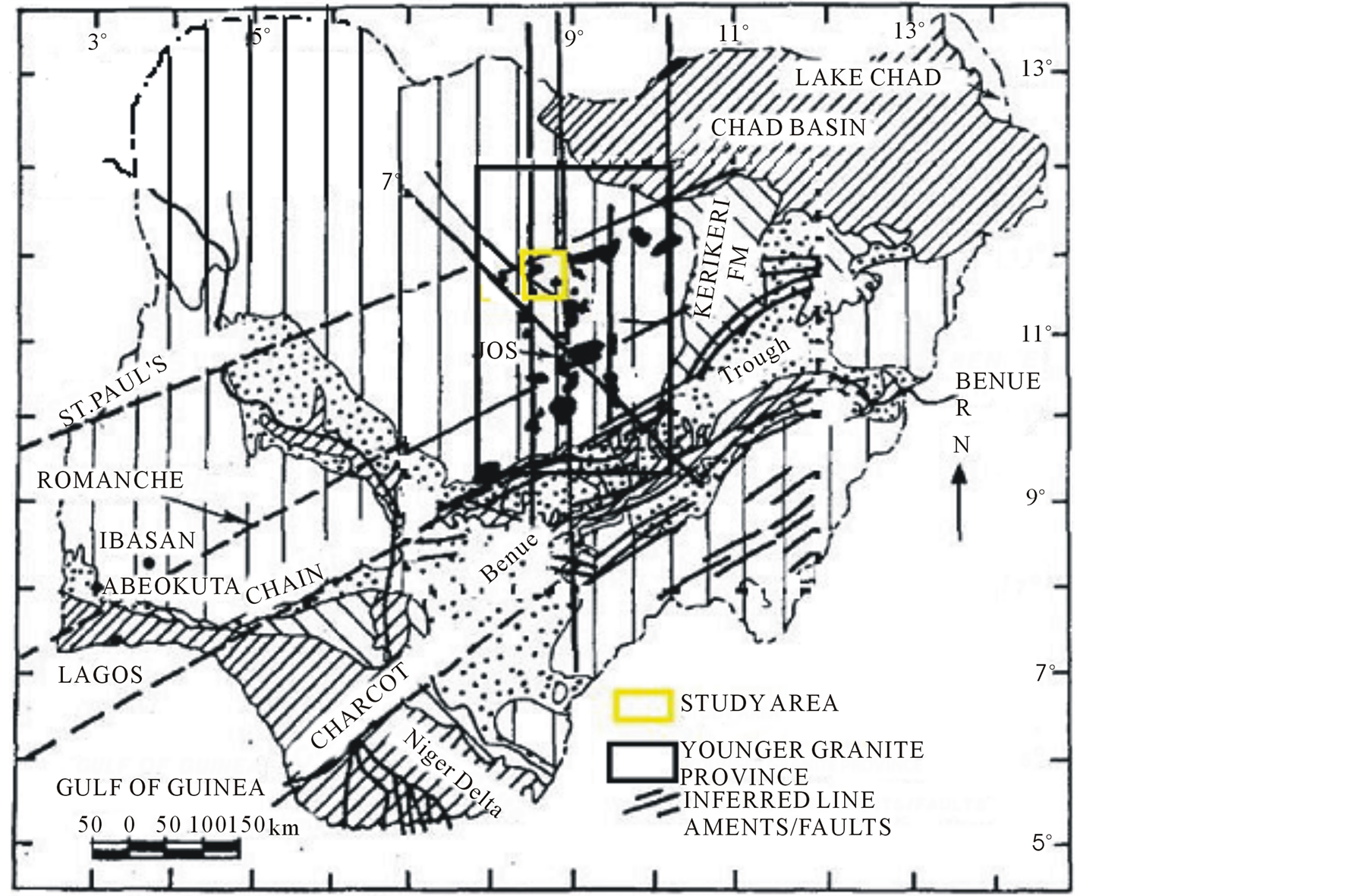
Figure 1. Simplified geological map of Nigeria showing the generalized geological setting of the Younger Granite complexes and the study area (modified after Ofoegbu and Hein, 1991).
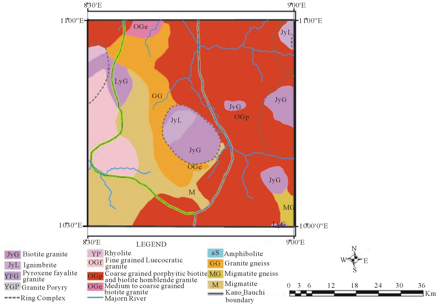
Figure 2. Geological map of the study area.
because of the sparse station density of the surveys; which additional data set would have provided. In view of the relevance of the additional data set, the aeromagnetic data of the study area and beyond, acquired in 1974 by the Geological Survey of Nigeria (at nominal flight height of 152.4 m, along N-S flight lines that were spaced at 2 Km interval), have been interpreted [11] -[15] . Much could not be deduced because the data only represent anomalies greater than 4 km (twice spatial sample interval, because of aliasing effect) and the interpretation techniques that were used [16] [17] . The interpretation by [14] , which mainly focused on the study area, was general and it related the distinct magnetic character as the expression of ring complexes. The study also revealed lineaments that trend along NW-SE and NE-SW direction. Interestingly, high resolution aeromagnetic data of the study area, whose interpretation will reveal subtle anomalies, have been acquired by the Nigerian Geological Survey Agency (NGSA). However, the data have not been studied to fill the gap created by the limitations of the previous geophysical studies. As such, the broad aim of this study is to use the high resolution airborne magnetic data to provide new insight on the structural setting of the study area.
2. Summary of Geology and Structural Setting of the Study Area
Detailed studies of the geology of the study area have been carried out [1] -[5] . However, only the aspect that is relevant to aeromagnetic interpretation has been summarized. Also, because Younger granites are often associated with distinct surface exposure, topography of the study area has also been included in the review (Figure 3).
As revealed by the geological map, the study area is largely covered by basement rocks while the rest is covered by ring complexes.
The basement rocks consist of two groups; the ancient metasediments that are considered to be older than 2000 m.y and the group that mainly consist of migmatites, granite-gneisses and Older Granites that is believed to have resulted from remobilization during the Pan-African orogeny [9] . This basement has been subjected to different episodes of folding and faulting. The dominant foliation is roughly north-south with variations between NW-SE and NE-SW [18] . Fractures and shear zones also characterize the basement. They consist of E-W trending fractures, which are perhaps the oldest fractures and almost obliterated. Others are N-S fractures that resulted from brittle deformation and twin conjugate sets of NE/SW and NW/SE and the NNE/SSW and NNW/ SSE sets, produced by transcurrent movements [18] .
The ring complexes are mainly associated with surface exposure that raised between the range of 500 and 1350 m above mean sea level (Figure 3). Three complete complexes, namely Ririwai, Gamawa and Zuku, and parts of Banke, Ningi and Tibchi-Yeli complexes outcrop in the study area. Their evolution and those in the province follow the same pattern. They began with volcanic phase that was associated with eruption of large volume of rhyolites via ring fractures, then followed by formation of ring dykes of granite-porphyry upon subsidence of the rocks interior to the ring fracture. Intrusion of arfvedsonite and biotite granite belonged to the plutonic phase that ended the evolution [2] . While ring fracture and cauldron subsidence are considered as the major controls that governed the emplacement of the Nigerian Younger Granites [2] [4] [19] , the sites of the emplacement have been suggested to be influenced by lineaments; a feature whose origin have been differently suggested [20] [21] . [20] relates the emplacement sites of ring complexes with the ancient lineaments that are associated with the separation of Africa from South America. [21] , on the other hand, believed that the sites of emplacement and the mineralization that are associated with them are influenced by the NE-SW and NW-SE lineaments that originated from the reactivation of the Pan-African shear zones and transcurrent faults.
The economic importance of the ring complexes include cassiterite and columbite that were mined in commercial quantities. Other minerals that are also associated with the complexes are wolframite, tungsten, zircon, sphalerite, thorite, etc.
3. Results and Discussion
3.1. Processing and Interpretation of High Resolution Aeromagnetic Data
The high resolution aeromagnetic (HRAM) data of the study area, named sheet 126, were sourced from the Nigerian Geological Survey Agency (NGSA). The data, covering half-degree sheet and in scale of 1:100,000, were acquired at a flight altitude of 80 m, along NE-SW flight lines that were spaced at 500 m. The effect of regional geomagnetic field (IGRF; 2004) has been removed, implying that the sourced data are HRAM anomaly or resi-
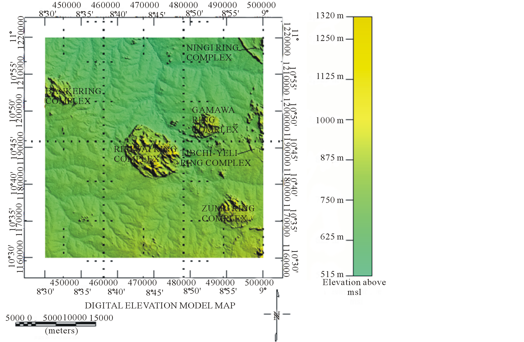
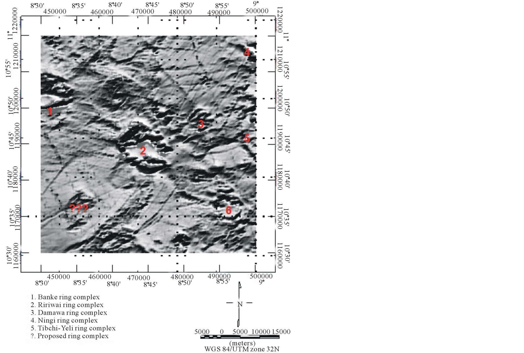
Figure 3. Digital elevation map of the study area.
dual field. Noise was removed by upward continuation of the aeromagnetic anomaly field to a height of 125 m before producing the upward continued aeromagnetic anomaly map of the sheet, in coloured (Figure 4) and shaded relief (Figure 5). Several processing techniques were also applied to the upward continued aeromagnetic anomaly data but only the enhancement with optimal information for the intended purpose of this paper was considered for interpretation.
Punctuated by pockets of distinct magnetic anomalies, almost circular in shape, the upward continued aeromagnetic anomaly map (Figure 4) is mainly characterized by regional NW-SE trending pattern that is consistent with the Pan African structural trend of the basement complex [18] ; except at the extreme north of the map where the trend is an E-W orientation. The distinct magnetic anomalies, clearly revealed in Figure 5, coincide spatially with outcropping ring complexes of the study when the geological and the shaded relief of the upward continued aeromagnetic anomaly maps of the study area are overlain (Figure 6). Also, an anomaly with the same feature with the anomalies of the ring complexes is also revealed by the overlain map (indicated with question marks) but without an associated surface manifestation (outcrop). This anomaly, bounded by longitude 8˚32'E and 8˚38'E and latitude 10˚32'N and10˚40'N, is believed to be an intrusion, probably a ring complex without a surface exposure, similar to that suggested by [9] in the north eastern part of the province and by [22] - [25] in central Brazil.
The north eastern part of Banke ring complex, in Figure 6, is characterized by undulating wavelike-shaped feature that extends towards Ririwai ring complex, which is consistent with anomaly pattern of a fold. Axis of the fold trends in the NE direction. Smaller pattern of such fold also trend along the same direction from the SSE flank of the non outcropping anomaly towards southern part of Ririwai ring complex. The rocks of the area with the inferred fold structure are granite gneiss and migmatite gneiss. Field and laboratory studies of the rocks revealed trend of folds in different directions [18] , including the direction that coincide with the direction of the folds inferred from Figure 6. Positions of the inferred folds close to the few ring complexes could imply that the emplacement of complexes constitute additional perturbation that allowed the observed folds. The study area, revealed by Figure 5, is characterized by lineaments and is more obvious on shaded relief of First Vertical Derivative of the aeromagnetic anomaly map (Figures 7(a) and (b)). An overlay of the lineaments in Figure 7(a) on those on the geological map draped with the shaded relief of the upward continued aeromagnetic map (Figure 8) shows that majority of the lineaments trend along NW-SE and NE-SW directions. Some are overlain by some discrete anomalies that were earlier interpreted to be due to ring complexes. This may imply that the lineaments probably influenced the emplacement sites of the ring complexes by serving as the conduits that guided the location of the volcanic eruption that initiated each of the ring complex. This suggestion is shared by numerous scholars [15] [20] [21] [26] . In particular, a major lineament in the NW-SE orientation, overlain by both the anomalies due to Banke and the identified unexposed ring complex, appears to be part of the large northwest-trending lineament that extends into the Benue trough and beyond, which [27] described as one of the possible lineament systems that relates to magmatic occurrences. This lineament has been revealed by the map to be crossed over by a NE-SW lineament at the identified unexposed ring complex.
3.2. Depth to Structural Features
Euler deconvolution technique; used to determine depth and location of features that represent structures, is based on Euler’s homogeneity equation, where the homogeneity equation relates magnetic field to the location and depth of its sources with the equation:
 (1)
(1)
The homogenous function F in Equation (1) is the observed field at location (x,y,z) caused by the anomalous source at location  and N, degree of homogeneity, interpreted as structural index (SI), is directly relates to the shape of the source of the field [28] .

Figure 4. Upward continued aeromagnetic map of the study area.
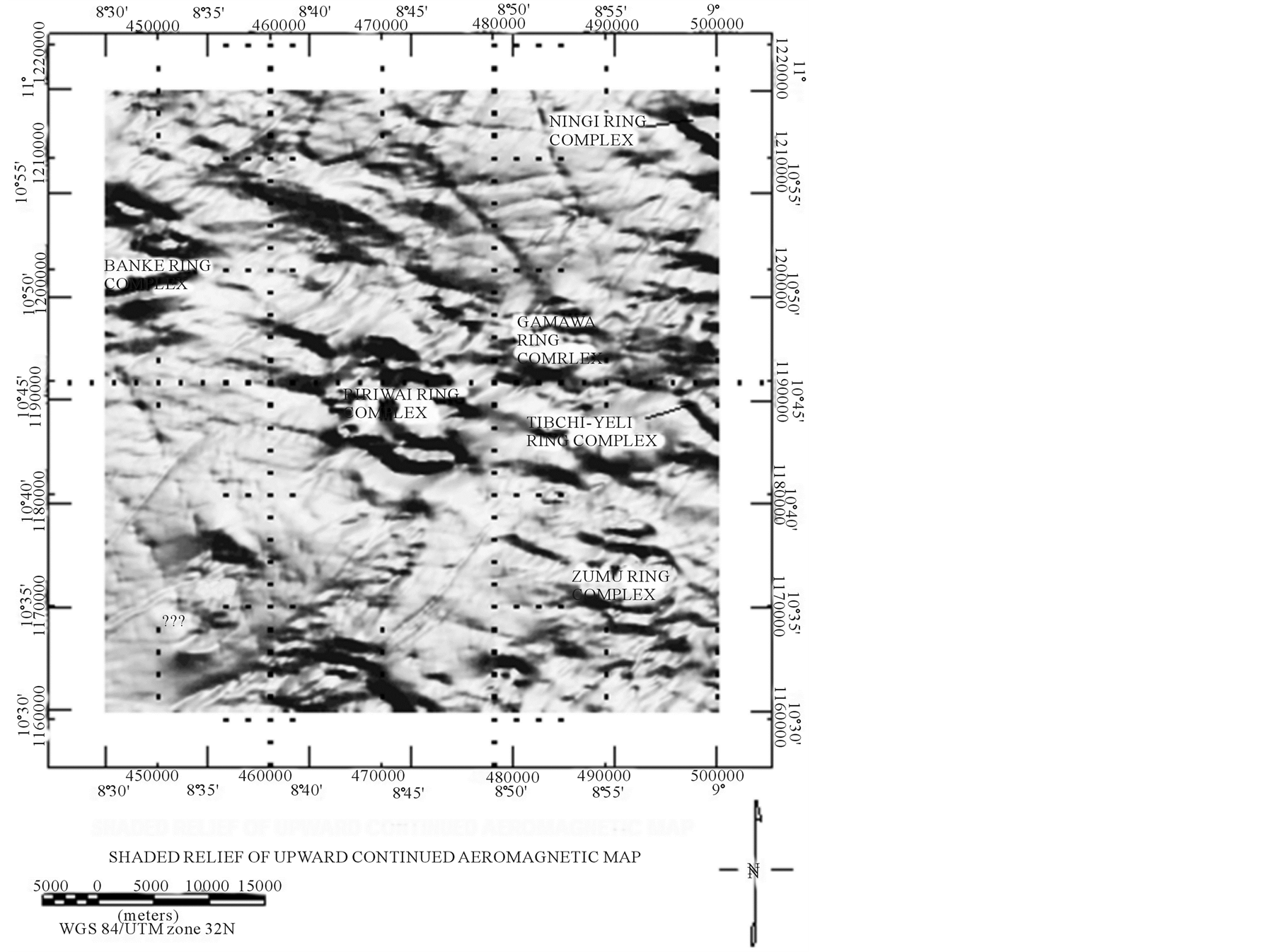
Figure 5. Shaded relief of upward continued aeromagnetic map of the study area.
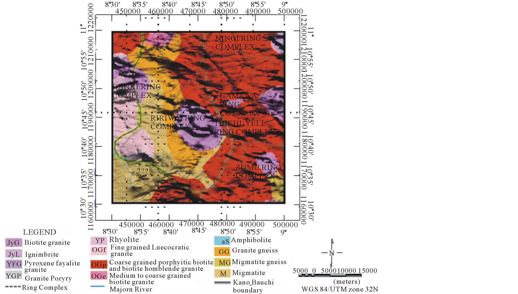
Figure 6. Geological map draped with shaded relief of upward continued aeromagnetic map.
 (a)
(a)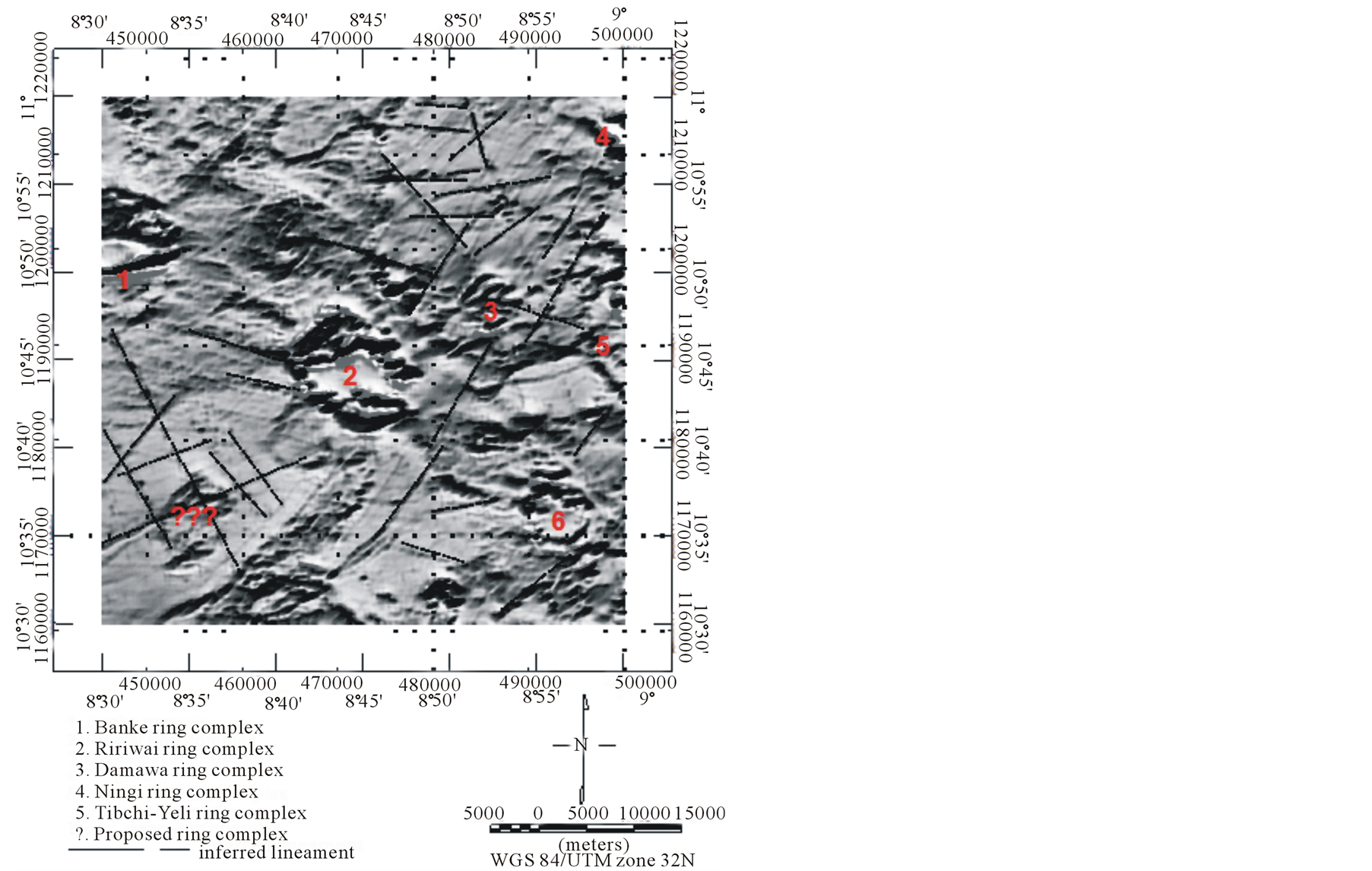 (b)
(b)
Figure 7. (a) Shaded relief of upward continued FVD map, (b) Lineaments delineated on shaded relief of upward continued FVD map.
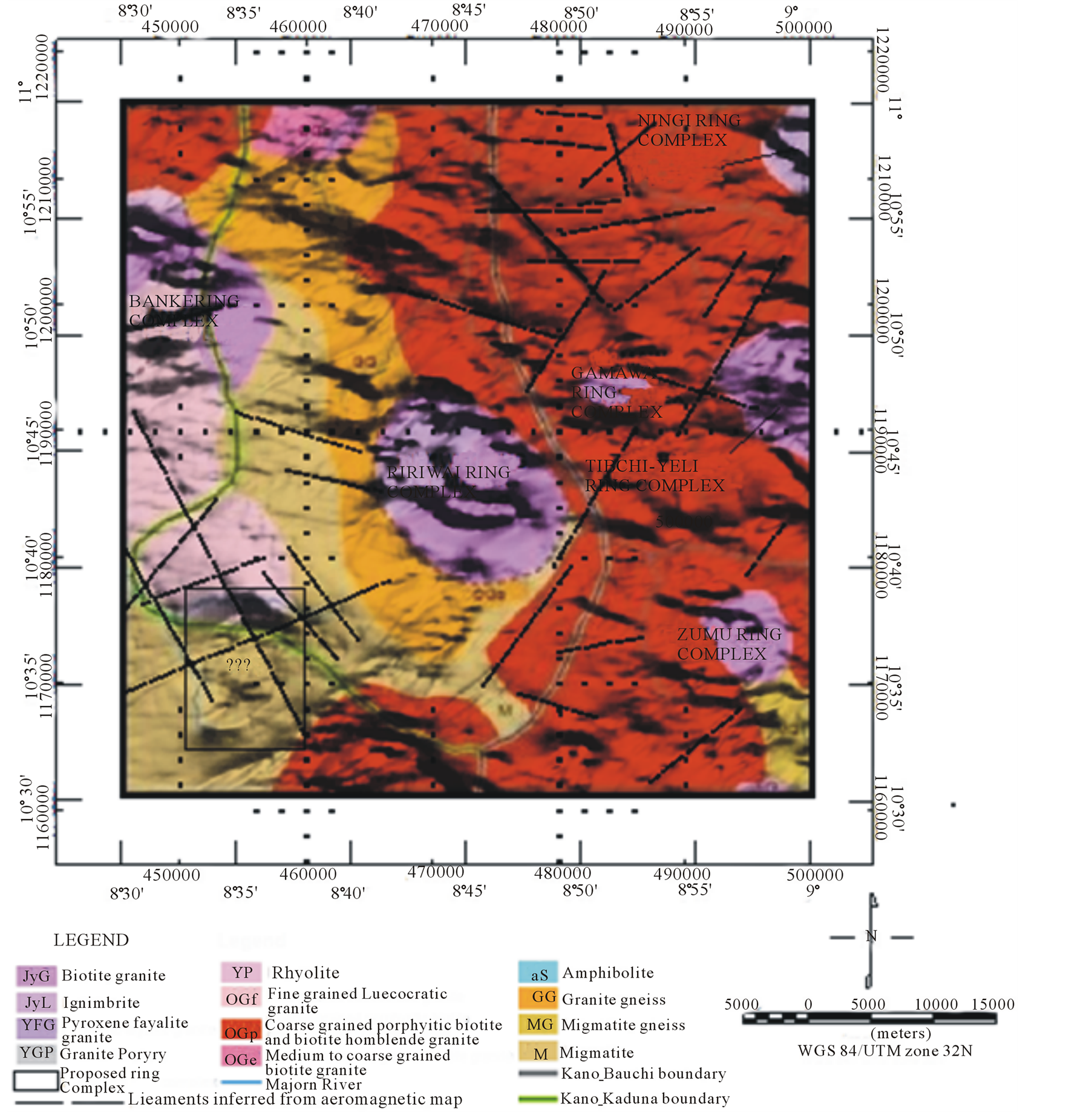
Figure 8. Draped map of the study area overlain with inferred lineaments.
The technique was applied to the upward continued aeromagnetic anomaly data to determine depth of ring complexes and folds in the study area. Structural index 2, which represents cylindrical shaped body, was chosen because magnetic field of alkaline intrusion (ring complex) can be inferred with the body [8] [24] . This index was ran with window lengths of 10, 15 and 20 and a combination of 20 × 20 window size with the index was used for the interpretation because it gave the tightest cluster of solutions that fitted the expected geological structure [29] . The result is displayed in Figure 9.
The results of the Euler solutions indicate that the depth of the ring complexes range from outcrop to 1800 m. For the inferred unexposed ring complex, the depth range from outcrop to 1200 m. It also revealed tightest cluster of solutions along inferred folds with depth that range from 0 to 1800 m.
4. Conclusion
Results of the study revealed details that are not previously known about the study area. The map in Figure 8 revealed presence of folds and magnetic anomaly with characteristics that is similar to those associated with ring
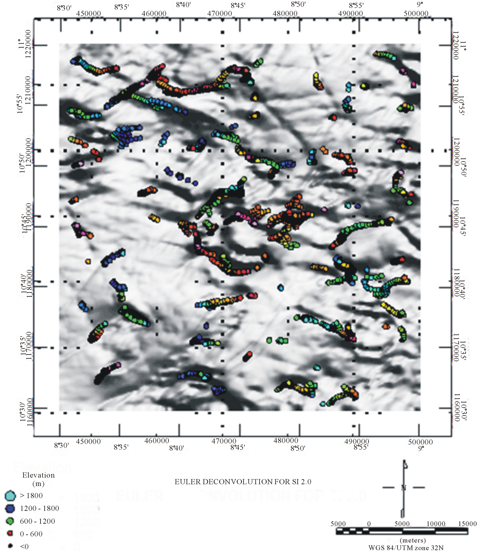
Figure 9. Euler deconvolution for structural index 2.0.
complexes in the study area but without the surface manifestation that is associated with the complexes. The observed magnetic anomaly underlain by cross-over of major lineaments may suggest presence of weak zone that probably allowed the volcanic eruption that initiated the emplacement of the source of the anomaly, unexposed ring complex. Because of the historical knowledge of the mining activities at the neighbouring complexes in the study area, the unexposed ring complex may be associated with economic minerals. Depth of the inferred unexposed ring complex has been revealed by the Euler deconvolution results to range from outcrop to 1200 m. It also revealed tightest cluster of solutions along inferred folds with depth that ranged from 0 to 1800 m.
References
- Bennett, J.N., Turner, D.C. and Ike, E.C. (1984) The Geology of Some Northern Nigerian Anorogenic Ring Complexes. Overseas Geology and Mineral Resources, 61, 65 p.
- Jacobson, R.R.E. and Macleod, W.N. (1977) Geology of the Liruei, Banke and Adjacent Younger Granite Ring Complexes. Bulletin of Geological Survey of Nigeria, 33, 1-117.
- Kinnaird, J.A. (1985) Mineralization and Hydrothermal Alteration of the Alkaline Anorogenic Ring Complexes of Nigeria. Journal of African Earth Sciences, 3, 229-251. http://dx.doi.org/10.1016/0899-5362(85)90038-7
- Turner, D.C. (1972) Structural and Tectonic Setting of the Younger Granite Ring Complexes of Nigeria and Southern Niger. Part I: Ring Complexes and Their Component Units. Savana I, 223-236.
- Turner, D.C. (1989) Structure and Petrology of the Younger Granite Complexes. In: C. A. Kogbe, Ed., Geology of Nigeria, 2nd Edition, Elizabethan Publ. Co., Lagos, 175-190.
- Ajakaiye, D.E. (1968) A Gravity Interpretation of the Liruei Younger Granite Ring Complex of Northern Nigeria. Geological Magazine, 105, 256-263. http://dx.doi.org/10.1017/S0016756800052274
- Ajakaiye, D.E. (1970) Gravity Measurements over the Nigerian Younger Granite Province. Nature, 225, 50-52. http://dx.doi.org/10.1038/225050b0
- Ajakaiye, D.E. (1974) A Gravity Profile across the Banke Ring Complex, Nigeria. Geoexploration, 12, 59-66. http://dx.doi.org/10.1016/0016-7142(74)90007-6
- Ajakaiye, D.E. (1989) A Gravity Survey over the Nigerian Younger Granite Province. In: C. A. Kogbe, Ed., Geology of Nigeria, 2nd Edition, Elizabethan Publ. Co., Lagos, 227-244.
- Ajakaiye, D.E. and Sweeney, J.F. (1974) A Three-Dimensional Gravity Interpretation of the Dutsin-Wai Complex, Nigerian Younger Granite Province. Tectonophysics, 24, 331-341. http://dx.doi.org/10.1016/0040-1951(74)90016-X
- Ajakaiye, D.E., Hall, D.H. and Millar, T. (1982) Preliminary Interpretation of Aeromagnetic Data across the Central Crystalline Shield of Nigeria. Annual Report, Centre for Precambrian Studies, 63-68.
- Ajakaiye, D.E., Hall, D.H. and Millar, T. (1985) Interpretation of Aeromagnetic Data across the Central Crystalline Shield Area of Nigeria. Geophysical Journal of the Royal Astronomical Society, 83, 503-517. http://dx.doi.org/10.1111/j.1365-246X.1985.tb06500.x
- Ajakaiye, D.E., Hall, D.H., Ashiekaa, J.A. and Udensi, E.E. (1991) Magnetic Anomalies in the Nigerian Continental Mass Based on Aeromagnetic Surveys. Tectonophysics, 192, 211-230. http://dx.doi.org/10.1016/0040-1951(91)90258-T
- Aina, A. and Olarewaju, V.O. (1992) Geological Interpretation of Aeromagnetic Data in Some Part of Northcentral Nigeria. Journal of African Earth Sciences, 14, 103-109. http://dx.doi.org/10.1016/0899-5362(92)90059-L
- Ofoeghu, C.O. and Hein, K. (1991) Analysis of Magnetic Data over Part of the Younger Granite Province of Nigeria. Pure and Applied Geophysics, 136, 173-189. http://dx.doi.org/10.1007/BF00876370
- Telford, W.M., Geldert, L.P., Sheriff, R.E. and Keys, D.A. (1990) Applied Geophysics. Cambridge University Press, Cambridge.
- Blakely, R.S. (1995) Potential Theory in Gravity and Magnetic Applications. Cambridge University Press, Cambridge. http://dx.doi.org/10.1017/CBO9780511549816
- Oluyide, P.O. (1988) Structural Trends in the Nigerian Basement Complex. Precambrian Geology of Nigeria, Geological Survey of Nigeria, 93-98.
- Bowden, P. and Turner, D.C. (1974) Peralkaline and Associated Ring Complexes in the Nigeria-Niger Province, West Africa. In: H. Sorensen, Ed., Alkaline Rocks, John Wiley & Sons New York, 330-351.
- Wright, J.B. (1970) Control of Mineralization in the Older and Younger Tin Fields of Nigeria. Economic Geology, 65, 945-951. http://dx.doi.org/10.2113/gsecongeo.65.8.945
- Kinnaird, J.A. and Bowden, P. (1987) African Anorogenic Alkaline Magmatism and Mineralization—A Discussion with Reference to the Niger-Nigeria Province. Geological Journal, 22, 279-340. http://dx.doi.org/10.1002/gj.3350220622
- Mantovani, M.S.M., Rugenski, A., Diogo, L.A. and Shukowsky, W. (2005) Integrated Geophysical Investigation of a Possible New Alkaline Occurrence in SE Brazil. Journal of South American Earth Sciences, 20, 259-266. http://dx.doi.org/10.1016/j.jsames.2005.05.011
- Dutra, A.C. and Marangoni, Y.R. (2009) Gravity and Magnetic 3D Inversion of Morro do Engenho Complex, Central Brazil. Journal of South American Earth Sciences, 28, 193-203. http://dx.doi.org/10.1016/j.jsames.2009.02.006
- Dutra, A.C., Marangoni, Y.R. and Junqueira-Brod, T.C. (2011) Investigation of the Goiás Alkaline Province, Central Brazil: Application of Gravity and Magnetic Methods. Journal of South American Earth Sciences, 33, 43-55. http://dx.doi.org/10.1016/j.jsames.2011.06.004
- Louro, V.H.A. and Mantovani, M.S.M. (2012) 3D Inversion and Modeling of Magnetic and Gravimetric Data Characterizing the Geophysical Anomaly Source in Pratinha I in the Southeast of Brazil. Journal of Applied Geophysics, 80, 110-120. http://dx.doi.org/10.1016/j.jappgeo.2012.01.013
- Kogbe, C.A. (1985) Landsat Imagery Interpretation Map of Curve-Linear Structures in North-Central Nigeria. Journal of African Earth Sciences, 3, 269-270. doi.org/10.1016/0899-5362(85)90041-7
- Wright, J.B. (1989) Volcanic Rocks in Nigeria. In: C. A. Kogbe, Ed., Geology of Nigeria, 2nd Edition, Elizabethan Publ. Co., Lagos, 125-173.
- Thompson, D.T. (1982) EULDPH—A Technique for Making Computer Assisted Depth Estimates for Magnetic Data. Geophysics, 47, 31-37. http://dx.doi.org/10.1190/1.1441278
- Reid, A.B., Allsop, J.M., Granser, H., Millett, A.J. and Somerton, I.W. (1990) Magnetic Interpretation in Three Dimensions Using Euler Deconvolution. Geophysics, 55, 80-91. http://dx.doi.org/10.1190/1.1442774