International Journal of Geosciences
Vol.4 No.6A2(2013), Article ID:36140,13 pages DOI:10.4236/ijg.2013.46A2007
Classification of River Reaches on the Little Disturbed East Alligator River, Northern Australia
1Environmental Research Institute of the Supervising Scientist, Darwin, Australia
2School of Environmental and Life Sciences, The University of Newcastle, Ourimbah Campus, Ourimbah, Australia
3Research Institute for the Environment and Livelihoods, Charles Darwin University, Darwin, Australia
Email: *Mike.Saynor@environment.gov.au
Copyright © 2013 Michael John Saynor, Wayne D. Erskine. This is an open access article distributed under the Creative Commons Attribution License, which permits unrestricted use, distribution, and reproduction in any medium, provided the original work is properly cited.
Received June 12, 2013; revised July 17, 2013; accepted August 9, 2013
Keywords: River Reaches; River Types; Sandstone Gorge; Anabranching Rivers; Cuspate Tidal Meanders; Wetlands and Channel Billabongs
ABSTRACT
The East Alligator River drains a 7000 km2 catchment in northern Australia comprised largely of Aboriginal land and has a very low average population density of about 0.15 persons per km2. River reaches were classified according to geomorphic features on both the East Alligator River and its major tributary, Magela Creek, next to which is located the Ranger uranium mine. Sixteen reaches were described for the 241.4 km of the East Alligator River and ten reaches were described for the 118.8 km of Magela Creek. The dominant river types on the East Alligator River were various types of anabranching rivers, sandstone gorges and cuspate tidal meanders. On Magela Creek the dominant river types were wetlands and channel billabongs, island anabranching and sandstone gorges. It is unusual for anabranching rivers and gorges to be so dominant. Current river classification schemes could not accommodate all the various river types and need to be modified so that tidal channels are covered in more detail and so that the classification of anabranching rivers recognises that sand-bed varieties occur in partly confined valley settings.
1. Introduction
River and floodplain classification have long been a topic of interest to Geographers. Professor W. M. Davis [1] first classified rivers into three developmental stages (young, mature, old) and then further classified drainage network patterns (for example, trellis, dendritic, radial, etc.). Ref. [2] identified three types of floodplain based on the genetic relationship between channel pattern and floodplain structure. These were meander plains, covered plains and bar plains. Ref. [3], much later, added anastomotic plain to the list.
Rivers or stream channels are now defined in Australia as linear, generally sinuous, open depressions characterized by a bed and banks [3]. They transmit water and its dissolved material plus fine and coarse sediment from the land surface to temporary storage areas, such as wetlands, small deltas, fans and floodouts, or to permanent sinks, such as large deltas and fans, large lakes and the ocean. Sediment entrainment, transport and deposition can go through many cycles of temporary storage before sediment reaches its final sink. The frequency of flow may be highly variable, ranging from permanent to episodic. A distinction is sometimes made between rivers and creeks on the basis of size, with creeks being smaller than rivers [4].
In Australia, the combined classification of rivers and floodplains was first attempted by [5] and then a different approach was adopted by [6]. Internationally, both Australian schemes were developed after what had been proposed in the United States of America [7,8].
Schemes for the systematic recording of geomorphic and associated information on river channel and valley characteristics for homogeneous short river reaches have been proposed [9-14]. Reference 11 emphasised the importance of placing a river in its terrain or landscape context, a theme revisited by [6]. These schemes are suitable for inventory purposes but require detailed information based partly on field measurements or observations. This can be very difficult to complete where there is no ground access by road or boat and where permissible aerial access by helicopter is very difficult, such as on most of the East Alligator River, northern Australia (Figure 1). Furthermore, indigenous land tenure in Australia can make access difficult to non-indigenous people as well as those from other clans.
As large-scale irrigated agriculture attempts to move to tropical Australian rivers, our current understanding of the types of rivers and their aquatic habitats, among other things, must be known in detail to prevent similar river degradation to that which has occurred in southern Australia [15]. Australian tropical rivers have not received the same research attention as their temperate counterparts [16,17] and, as a result, there are many rivers, about which little is known [18]. This paper concentrates on the tropical coastal East Alligator River and classifies the 241.4 km of the East Alligator River and the 118.8 km of its major tributary, Magela Creek, into geomorphologically homogeneous river reaches. The East Alligator River was selected because it is a minimally disturbed catchment with an average population density of about 0.15 person/km2 and because it contains an uranium mine in a World Heritage Listed National Park (see below). Each identified reach is then further classified into a specific river type based on a range of river typologies. Ma-
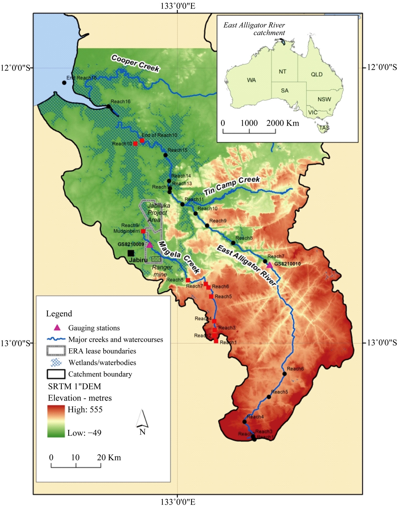
Figure 1. Little disturbed East Alligator River catchment in northern Australia.
gela Creek was also selected for classification because the Ranger Uranium Mine is located next to the channel [19].
2. East Alligator River and Magela Creek
2.1. Land Tenure
The East Alligator River is located 150 km east of Darwin and drains into van Dieman Gulf. Figure 1 shows the drainage basin which is composed of the World Heritage Listed Kakadu National Park, indigenous land forming part of Arnhem Land Aboriginal Reserve and two mining leases (Ranger and Jabiluka) currently held by Energy Resources of Australia (Figure 1). The mining leases are excised from Kakadu National Park [20] and are to be rehabilitated so that they are suitable for inclusion in Kakadu National Park. A former uranium mine, Nabarlek, is located on Cooper Creek in Arnhem Land [20]. Kakadu National Park is jointly managed by the traditional owners and the Australian Government through Parks Australia via a Board of Management.
The catchment area of the East Alligator River is about 7000 km2 and the catchment area of Magela Creek is about 1600 km2.
2.2. Landforms
The main large-scale landforms of the East Alligator River catchment are an extensive sandstone upland known, as the Arnhem Land plateau, the spectacular edge of the plateau, known as the Arnhem escarpment, an extensive, highly weathered lowlands below the escarpment, known as the Koolpinyah surface, floodplains and wetlands, and deltaic estuarine floodplains along the lower river [21]. Each is briefly described below.
The Arnhem Land plateau is an exhumed, essentially sandstone, tabular upland and constitutes most of the catchment of the East Alligator River. It produces low sediment yields of predominantly sandy sediment [22]. A deeply incised, trellised drainage pattern has developed along closely spaced joints and faults in the sandstone [21]. It coincides with high terrain in Figure 1.
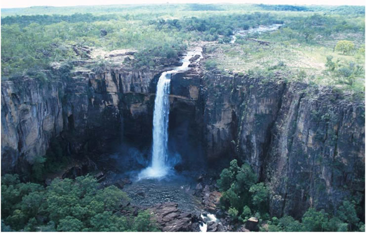
The Arnhem escarpment is a striking scenic feature at the edge of the sandstone plateau (edge of the high terrain in Figure 1). It varies from 30 to 330 m high and rivers exiting the plateau either flow over spectacular waterfalls (for e.g. Magela Falls on Magela Creek) or dissect the scarp by relatively long, narrow, deep bedrock gorges, which follow joints and faults (for e.g. East Alligator River).
The Koolpinyah surface is a monotonous lowland between the Arnhem escarpment and either erosion-resistant residuals or floodplains and wetlands or the deltaic estuarine floodplain (low terrain in Figure 1). It has developed across a wide range of lithologies and is a Tertiary lateritised palaeoplain [23,24] which experienced a second phase of lateritisation in the late Quaternary [25].
Rivers crossing the Koolpinyah Surface have cut shallow trenches which are occupied by sandy anabranching channels, floodplains, palaeochannels and wetlands [26- 28]. Magela Creek has been investigated in detail [27, 28]. Multiple Pleistocene terraces and palaeochannels flank the contemporary anabranching channel downstream of the Arnhem escarpment which started aggrading with sand about 5 - 7 ka [27]. This sand is slowly prograding downstream and is burying flood basins, billabongs and wetlands on lower Magela Creek [27]. Extensive flood basins of Holocene organic clay sediments lie between the upstream sandy alluvial plain and the downstream deltaic estuarine plain on the East Alligator River (Figure 1). The flood basin sediments stratigraphically overlie Holocene estuarine sediments [28].
The deltaic estuarine plain, based on results for the South Alligator River, exhibits four distinct channel types which in upstream sequence are the estuarine funnel, sinuous reach, cuspate meander reach and the upstream reach [29,30]. The deltaic estuarine plain developed in three major phases over the last 8 ka as sea level rose from about −14 m below sea level to its present level after 5.8 ka BP [29,30]. The “transgressive phase” (8 - 6.8 ka BP) marked the final marine flooding of the prior valley and the development of mangrove forests. Then the “big swamp phase” (6.8 - 5.3 ka BP) occurred as sea level stabilized around its present level and mangrove forests became established over most of the present estuarine floodplain. The “sinuous/cuspate phase” began about 5.3 ka BP and was characterized by the establishment of a meandering estuarine channel flanked by a marginal zone of mangroves. Freshwater swamps developed and overbank deposits were laid down on the floodplain surface. On Magela Creek, mangroves retreated downstream from Mudginberri after 4.4 ka BP and the strength of tidal connection was progressively severed and the former tidal channels were dismembered [28]. The channel and floodplain billabongs of [31,32] represent remnants of the former tidal channel. Between about 1.5 and 1.0 ka BP, freshwater wetlands formed over the lower 250 km2 of Magela Creek (Figure 1) [28].
2.3. Geology
The Arnhem Land plateau and escarpment are composed of resistant, horizontally bedded, vertically jointed, strongly ferruginous, medium quartz sandstone of the Palaeoproterozoic (Statherian) Mamadawerre Sandstone, Gumarrimbang Sandstone, Marlgowa Sandstone and McKay Sandstone of the Kombolgie Subgroup [33,34]. The sandstone is generally more than 95% medium to coarse grained, moderately well sorted, subrounded to subangular quartz grains with minor lithic fragments of quartzite and quartz-feldspar granophyric intergrowths [33]. A series of volcanic members (Nungbalgarri Volcanics and Gilruth Volcanic Member) were extruded contemporaneously with the sandstone [33].
The Koolpinyah Surface developed largely on Late Archaean Nanambu Complex basement rocks and Proterozoic Lower Cahill Formation which is the host of uranium mineralization in this area [33].The carbonate rich rocks of the Cahill Formation were deformed and metamorphosed before deposition of the Kombolgie Subgroup [33].
2.4. Climate and Hydrology
The East Alligator River catchment is located in the summer rainfall-tropical climatic zone, characterized by heavy periodic rains and generally hot and humid conditions from November to March and essentially dry and mild to warm conditions from April to October [35]. Rainfall variability in the summer rainfall-tropical climatic zone is low to moderate but high daily totals are recorded during tropical cyclones [35]. On average, one cyclone per year affects the Northern Territory coast [36]. Mean and median annual rainfall are similar at each station (rainfall distribution is not skewed) [37] and decreases from about 1500 mm/year at the mouth of the East Alligator River to about 1000 mm/year in the south of the catchment. Alternating sub-decadal to multi-decadal, wet and dry periods have occurred over the last 136 years [37]. Consecutive time periods were usually statistically significantly different to each other and each wet and dry period were statistically identical to each other [37]. It is essential that any field measurements of geomorphic and hydrologic processes are correctly assigned to the relevant wet or dry period [37].
Figure 2 shows mean monthly discharge at gauging stations G8210010 on the East Alligator River and at G8210009 on Magela Creek (Figure 1). On the East Alligator River, streamflow usually commences in December and persists until April. During wet years, flow can persist right through the year although baseflow is very low. Streamflow on Magela Creek is similar to the East Alligator River, except that it never persists right through the year (Figure 2). The largest recorded flood at both stations occurred in late February/early March 2007.
3. River Reaches
3.1. Methods
The approach adopted to identify, name and describe river reaches in the study area follows [38]. River reaches are homogeneous lengths of channel within which hydrologic, geologic and adjacent catchment conditions are sufficiently constant so that a uniform river morphology is produced [11]. Alternatively, river reaches could be defined as relatively homogeneous associations of channel units which distinguish them from adjoining reaches [6,39]. However the latter approach requires too much field work for application in remote areas, such as the East Alligator River. Reaches are typically 2 to more than 100 km long but can be shorter and longer. It is relatively easy to identify the core length of a reach, but it is more difficult to define precisely the boundaries of a reach because of their transitional nature [40].
Formal names have been given to reaches and comprise at least three terms. The first term is a geographic name for a location or feature within or next to the reach. The second term is a geomorphological descriptor for one of the dominant characteristics of the reach. The third term, when needed, is the word, reach or zone. This scheme has been applied to the mid-Goulburn River, Victoria by [40], to the Snowy River, New South Wales and Victoria by [41,42] and to the Hawkesbury-Nepean River, New South Wales by [43].
River reaches can then be classified into specific river types. Each identified reach on the East Alligator River and Magela Creek has been allocated to a river type according to the well-known classification schemes of Rosgen [44,45], Brierley and Fryirs [6] and Erskine et al. [18,46]. It is demonstrated below that each scheme has its strengths and weaknesses. However, these schemes cannot currently account for the range of river types found in the East Alligator River catchment. Clearly changes are required to all three schemes to enable classification of all river reaches in the East Alligator River catchment.
We do not believe that each reach of the same river type/style has progressed through the same evolutionary pathway. Therefore, each reach with the same river type/ style may not behave identically in future and different river management predictions are required for each reach, not each river type.
3.2. East Alligator River
The 241.4 km long East Alligator River has been classified into 16 reaches which are shown in Figures 1 and 3, and described from upstream to downstream in Table 1. Reach place names were obtained from topographic maps, geology maps and information sheets for Kakadu National Park. Examples of river reaches are shown in Figures 4 and 5.
This work revises our earlier, partial classification of the East Alligator River [47] in which we only used the river styles framework [6]. Furthermore, unlike the river styles framework [6], reach classification needs to emphasise the connections and disconnections between catchments, rivers and the ocean which are contingent, to
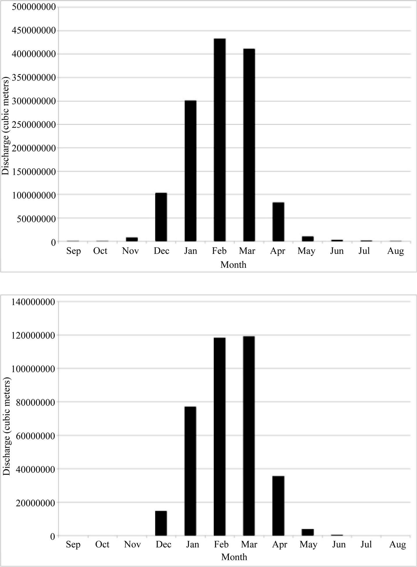
Figure 2. Mean monthly discharge at G8210010 on the East Alligator River and at G8210009 on Magela Creek. See Figure 1 for location of stations.
some degree, on what happens in estuaries which are important sediment stores [28-30]. Therefore, estuaries must be included in river classifications and not either ignored [44,45] or lumped into a single class which says nothing about sediment transport continuity and changes in channel behavior throughout the estuary. We are currently developing the classes of estuaries for inclusion in reach classification.
Channel scabland consists of extensive bedrock anabranching channels and scour pools eroded by catastrophic floods on bedrock uplands where the formative floods could not be contained in a single channel. They have been previously identified on the neighbouring Katherine River [48]. We have identified channel scabland for the first time at the upstream end of the Upper East Alligator Gorge (Table 1). Previous palaeoflood hydrology on the East Alligator River [49] was conducted in Reach 8 which the authors recognized was subject to scour and fill. Reach 6 is where we are currently concentrating palaeoflood investigations with Professor R. J. Wasson of the National University of Singapore.
The dominant river type on the East Alligator River is sandstone gorge although the various types of ana-
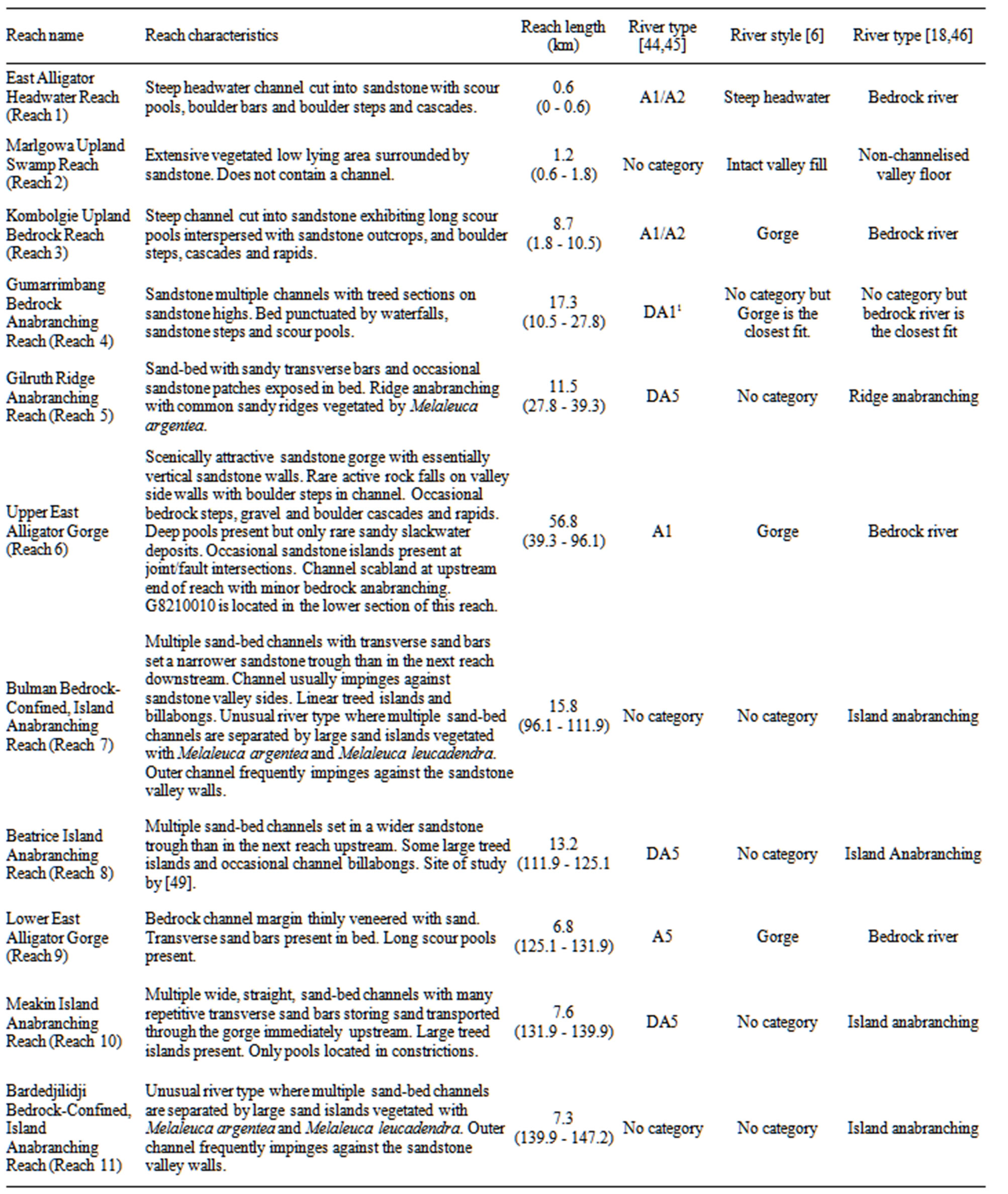
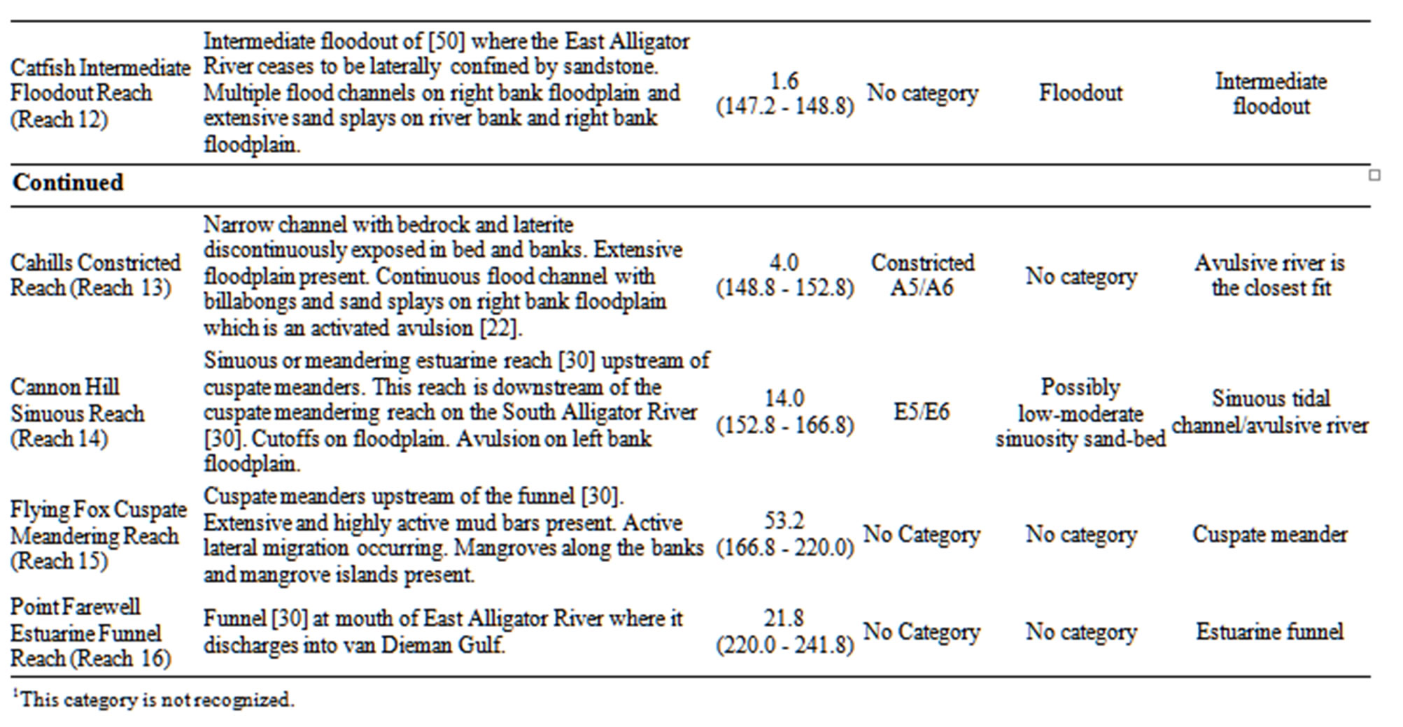
Table 1. River reaches on the East Alligator River. See Figures 1 and 3 for their location.
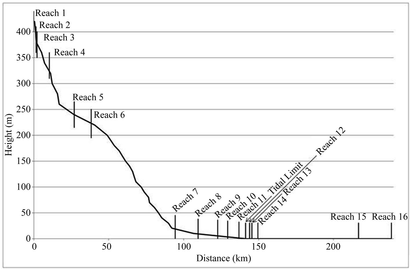
Figure 3. Longitudinal profile of the East Alligator River showing the river reaches described in Table 1. For location of river reaches see Figure 1.
 (a)
(a)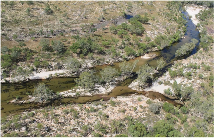 (b)
(b)
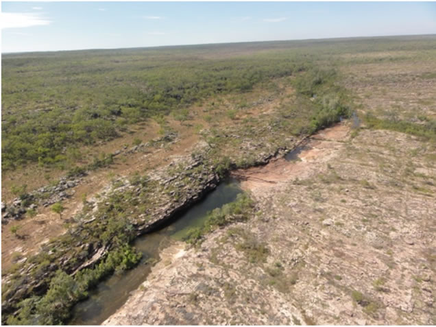
Figure 4. Examples of the river reaches identified on the East Alligator River. (a) Steep channel cut into sandstone on the Arnhem Land plateau showing scour pools and scoured sandstone surfaces on the East Alligator River in Reach 3 (Kombolgie Upland Bedrock Reach); (b) Ridge anabranching with sand ridges vegetated by Melaleuca argentea on the East Alligator River in Reach 5 (Gilruth Ridge Anabranching Reach). For location of river reaches see Figure 1 and for description of river reaches, see Table 1.
 (a)
(a)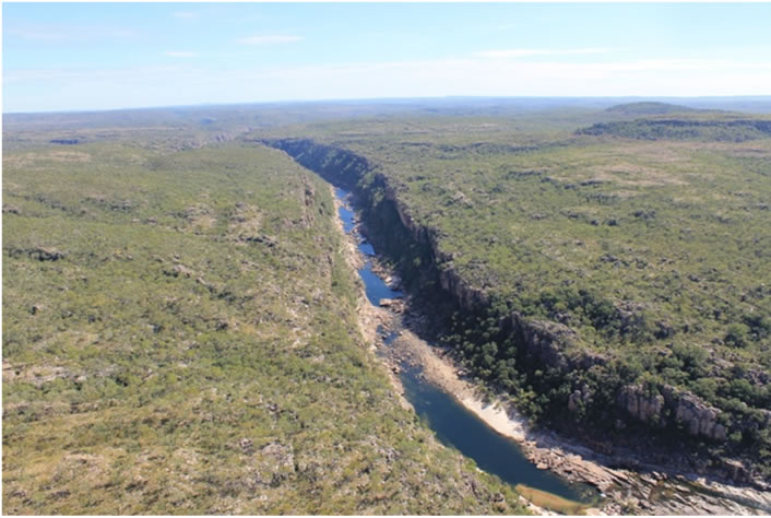 (b)
(b)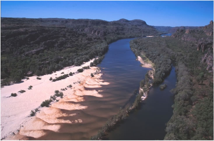 (c)
(c)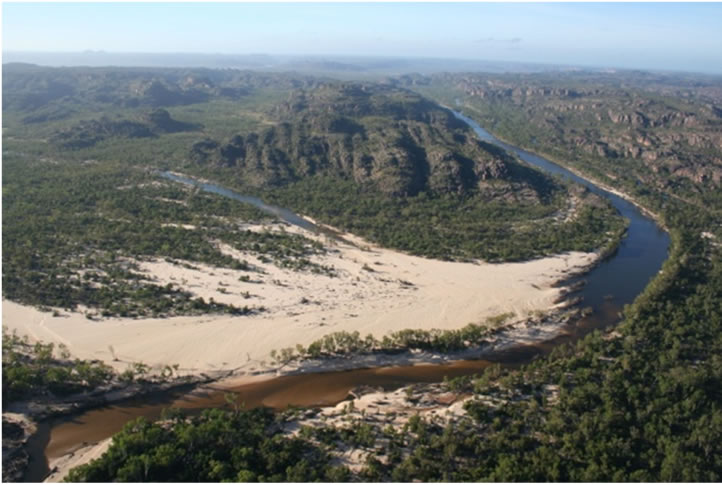 (d)
(d)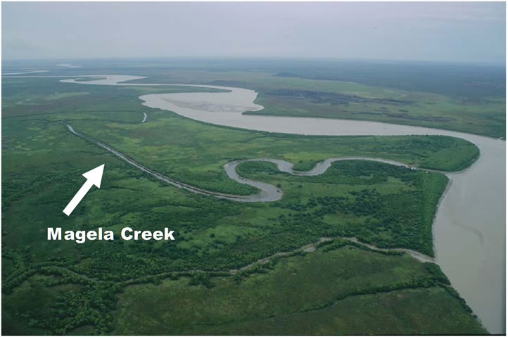 (e)
(e)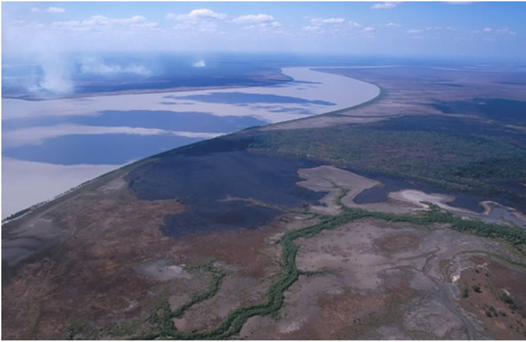 (f)
(f)
Figure 5. Examples of the river reaches identified on the East Alligator River and Magela Creek. (a) Magela Falls at the start of the Magela Falls Gorge Reach (Reach 7) on Magela Creek during the wet season. Note cap rock on the falls; (b) Section of Upper East Alligator Gorge (Reach 6) on the East Alligator River showing scour pools and cascades; (c) Upstream view of sandy transverse bars in the bed and large treed island on right side of photograph in Meakin Island Anabranching Reach (Reach 10) on the East Alligator River; (d) Upstream view of the Catfish Intermediate Floodout Reach (Reach 12) on the East Alligator River showing sand slug in bed of channel and extensive sand splays on bank and floodplain; (e) Junction of Magela Creek and East Alligator River showing cuspate meanders, bars and mangrove islands of the Flying Fox Cuspate Meander Reach (Reach 15) on the East Alligator River and the Magela Outflow Sinuous Reach (Reach 10) on Magela Creek; (f) Upstream view of Point Farewell Estuarine Funnel Reach (Reach 16) on the East Alligator River. For location of river reaches see Figure 1 and for description of river reaches, see Table 1 for East Alligator River and Table 2 for Magela Creek. Long profile of the East Alligator River showing location of all river reaches is included in Figure 3 and that for Magela Creek is included in Figure 6.
branching rivers are marginally longer (72.3 v 72.7 km) (Table 3). The anabranching river reaches on the East Alligator River do not occur in laterally unconfined valley settings, as proposed by [6]. Therefore, a new type of anabranching river must be recognized which is found in partly confined valley settings.
3.3. Magela Creek
The 118.8 km long Magela Creek has been classified into the 10 reaches shown in Figures 1 and 6, and described from upstream to downstream in Table 2. Examples of river reaches are shown in Figures 4 and 5.
Again sandstone gorges and anabranching reaches are common on Magela Creek, as on the East Alligator River (Table 3). The Ramsar-listed wetlands on lower Magela Creek (Nankeen Channel Billabong, Wetlands and Floodplain Reach in Table 2) represent a dismembered formerly tidal channel network [28]. Such atrophying tidal
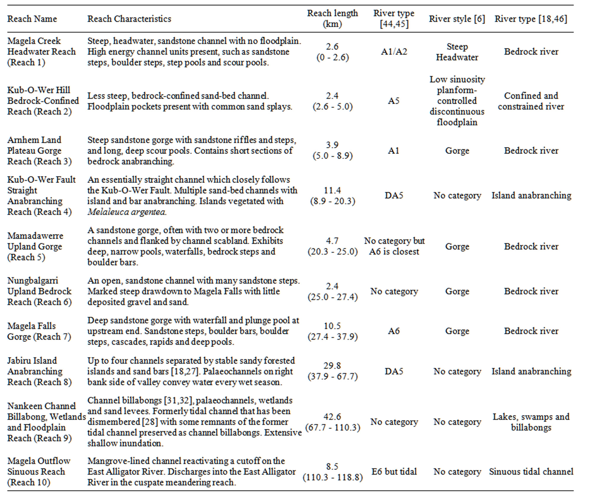
Table 2. River reaches on Magela Creek. See Figures 1 and 6 for their location.
channels are present right round Australia with excellent examples also present on the Snowy River estu-Ary in Victoria and on the Hawkesbury River estuary in New South Wales. This strengthens our claim that an appropriate estuary classification scheme must be developed for inclusion in a national river classification scheme. River styles [6] certainly do not do this although it might be able to be modified to include the wide range of tidal channels in Australia.
4. Discussion
All river classifications that we applied to the East Alligator River and Magela Creek, either do not accommodate all identified river reaches (i.e. no appropriate class) or fail to discriminate between different reach types (i.e. different reach types placed in same class). Clearly, if any of the river classification schemes were to be used for a national scheme in Australia, all would require extensive revision, including our own. In some cases, this is simply a matter of adding a class that is currently unrecognized. For example, Rosgen [44,45] currently does not recognize bedrock anabranching rivers but they can easily be accommodated in a new class DA1. A more serious issue is the inability of river styles [6] to handle all types of anabranching rivers. Under the current scheme, river styles recognizes only two types of anabranching river, wandering gravel bed and fine grained anabranching, both of which only occur in laterally unconfined valley settings. No anabranching rivers in the East Alligator River catchment belong to either category yet anabranching rivers are the dominant river type (Table 3).
Figure 4(b) shows ridge anabranching on the East Alligator River and Refs. [18,27] discuss island ana-branching on Magela Creek. Neither type of sand-bed channel
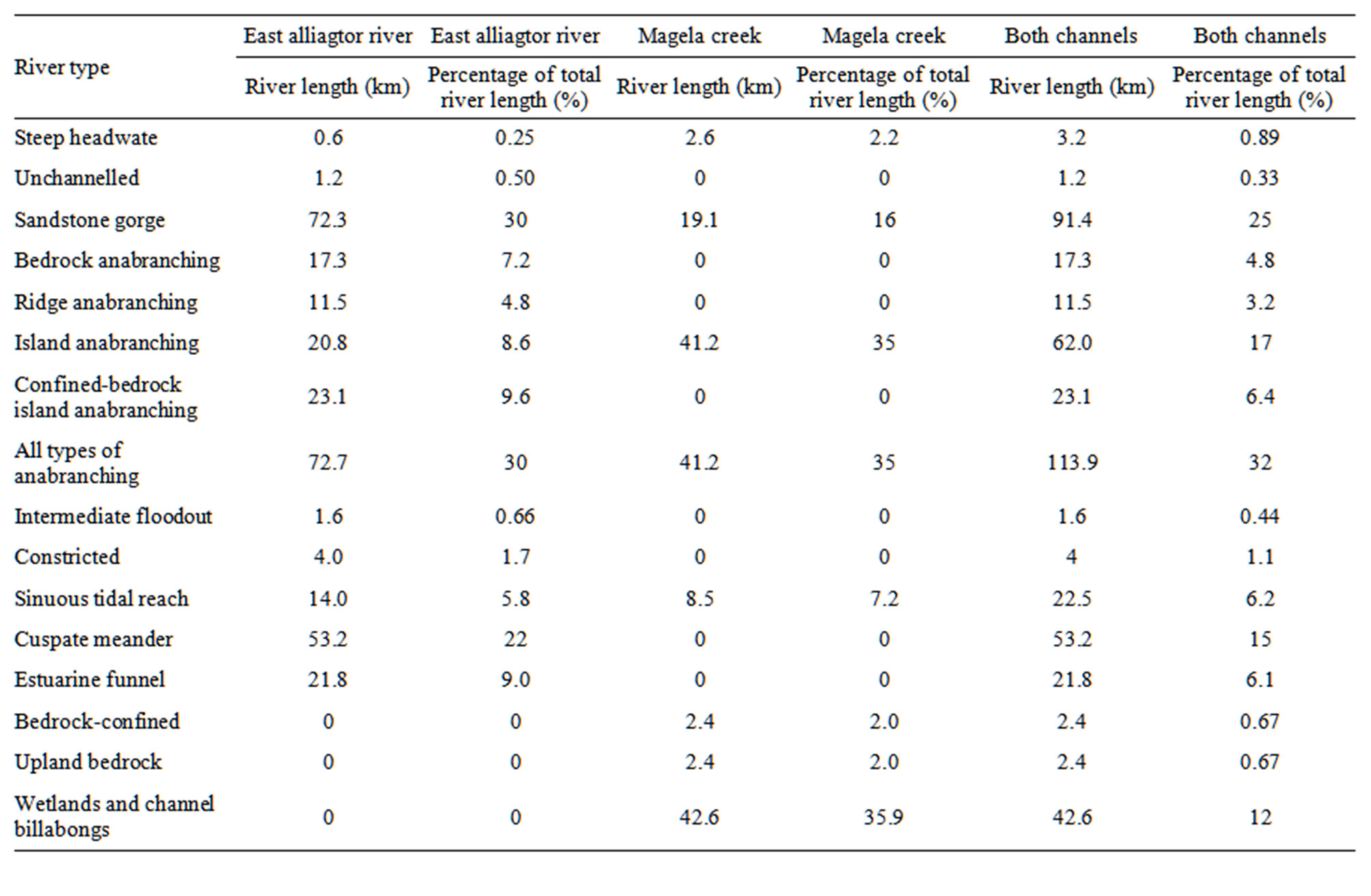
Table 3. Summary of river types on the East Alligator River and Magela Creek.
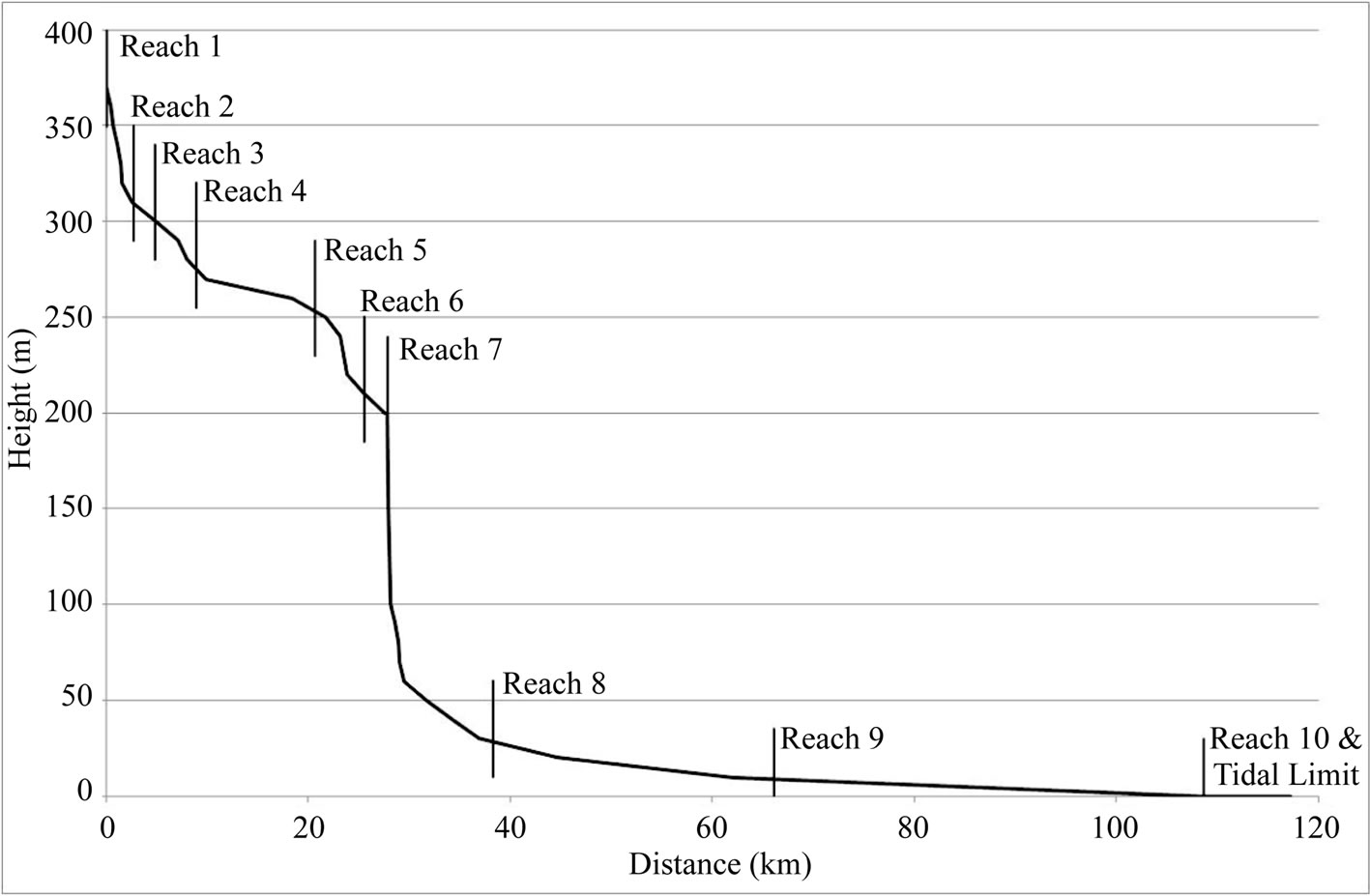
Figure 6. Longitudinal profile of Magela Creek showing the river reaches described in Table 2. For location of river reaches see Figure 1.
is currently accommodated by river styles [6]. Furthermore, we believe that there is a new anabranching river type that is bedrock-confined. We know the Bardedjilidji Bedrock-Confined, Island Anabranching Reach (Reach 11) of the East Alligator River (Table 1) the best because we have been researching it for many years [47]. The channel at the outer edge of the island belt impinges against sandstone for 25% of the valley length and, therefore, conforms to the partly confined valley setting of [6]. The sinuosity of the individual channels is very low (P < 1.1) and so are straight [51] or low sinuosity [6]. Each channel is separated by high, well vegetated islands although there is extensive erosion of the islands during extreme events [47]. Therefore, a new type of island anabranching channel should be added to [6] which is included in the partly confined valley setting and which is characteristed by multiple, straight, sand-bed channels (up to 4) separated by high treed islands equivalent to the floodplain of a single channel river. An anabranching category also needs to be added to the confined valley setting for bedrock anabranching rivers (Reach 4 on the East Alligator River in Table 1).
References [29,30] have clearly demonstrated that estuaries exhibit much spatial variation in morphology, sediments, hydrodynamics and vegetation. River classifications need to adequately account for these spatial variations by incorporating appropriate classes for all estuary types. In particular, connections and disconnections in water and sediment fluxes between different reaches must be adequately understood. This is not currently the case.
The East Alligator catchment is very old with the landscape having formed by erosion and weathering since the mid-Tertiary [21]. Despite major climate and sea level changes, gorges and bedrock-confined rivers (Figure 4(a) and Figures 5(a)-(c)) are still very common, forming 38.6% of the total river length classified (Table 3). This is geomorphologically unusual. The old landscape is currently producing low sediment but high water yields, except where disturbed by mining and feral animals [21, 22].
Ref. [49] undertook palaeoflood hydrology research in Reach 8 of the East Alligator River and found that the existing slackwater deposits were very young, only occurring at low elevations. Because they had not identified the river reaches on the East Alligator River, their study site was subject to frequent scour and fill, a fact that they explicitly recognized. It is now clear that such research should be completed in the Upper East Alligator Gorge (Reach 6) and we are undertaking this research.
On Magela Creek, we have identified channel scabland in the Mamadawerre Uplands Gorge (Reach 5) (Table 2). We are unaware of any of the previous geomorphic investigations of the East Alligator River recognizing this gorge and its associated channel scabland. Slackwater deposit investigations to determine palaeoflood hydrology should also be undertaken.
Further research is needed on Australia’s tropical rivers to better understand their form, processes and functioning before short-sighted politicians attempt to develop northern Australia. As part of this increased knowledge, classification and description of more rivers are needed urgently.
5. Conclusion
River reaches on the East Alligator River and Magela Creek, were classified according to geomorphic features. Sixteen reaches were described for the 241.4 km of the East Alligator River and ten reaches were described for the 118.8 km of Magela Creek. Dominant river types on the East Alligator River were anabranching rivers, sandstone gorges and cuspate tidal meanders. On Magela Creek, dominant river types were wetlands and channel billabongs, island anabranching and sandstone gorges. It is rare for anabranching rivers and gorges to be so dominant. Current river classification schemes could not accommodate all the river types and need to be modified so that tidal channels are covered in more detail and so that sand-bed varieties of anabranching rivers are recognised in partly confined valley settings.
6. Acknowledgements
This work was completed while WDE was on study leave from The University of Newcastle in 2010 at the Environmental Research Institute of the Supervising Scientist. Dr David Jones supported our research. Parks Australia and the Northern Lands Council gave permission for field work in Kakadu National Park and Arnhem Land, respectively. John Lowry prepared figures.
REFERENCES
- W. M. Davis, “The Geographical Cycle,” Geographical Journal, Vol. 14, No. 5, 1899, pp. 481-504. doi:10.2307/1774538
- F. A. Melton, “An Empirical Classification of Flood-plain Streams,” Geographical Review, Vol. 26, No. 4, 1936, pp. 593-609. doi:10.2307/209717
- J. G. Speight, “Landform,” In: The National Committee on Soil and Terrain, Australian Soil and Land Survey Field Handbook, CSIRO Publishing, Collingwood, 2009, pp. 15-72.
- J. D. Mollard, “Landforms and Surface Materials of Canada. A Stereoscopic Airphoto Atlas and Glossary,” Saskatchewan, 1974.
- S. J. Riley, R. F. Warner and W. D. Erskine, “Classification of Waterbodies in New South Wales,” Water Resources Commission of New South Wales, North Sydney, 1984.
- G. J. Brierley and K. A. Fryirs, “Geomorphology and River Management. Applications of the River Styles Framework,” Blackwell Publishing, Malden, 2005.
- L. M. Cowardin, V. Carter, F. C. Golet and E. T. La Roe, “Classification of Wetlands and Deepwater Habitats of the United States,” Office of Biological Services, Fish and Wildlife Service, US Department of Interior, Washington DC, 1979.
- L. M. Cowardin, “Wetlands and Deepwater Habitats: A New Classification,” Journal of Soil and Water Conservation, Vol. 37, No. 2, 1982, pp. 83-85.
- C. R. Neill and V. J. Galay, “Systematic Evaluation of River Regime,” Journal of Waterways and Harbours Division, Proceedings American Society of Civil Engineers, Vol. 93, No. 1, 1967, pp. 25-53.
- J. D. Mollard, “Airphoto Interpretation of Fluvial Features,” In: Subcommittee on Hydrology, Associate Committee on Geodesy and Geophysics, Natural Research Council of Canada, Fluvial Processes and Sedimentation, Hydrology Symposium No. 9, 1973, pp. 341-380.
- R. Kellerhals, M. Church and D. I. Bray, “Classification and Analysis of River Processes,” Journal of the Hydraulics Division, Proceedings of American Society of Civil Engineers, Vol. 102, No. 7, 1976, pp. 813-829.
- M. P. Mosley, “A Procedure for Characterising River Channels,” Ministry of Works and Development, Water and Soil, Miscellaneous Publication No. 32, 1982.
- A. J. Davenport, A. M. Gurnell and P. D. Armitage, “Habitat Survey and Classification of Urban Rivers,” River Research and Applications, Vol. 20, No. 6, 2004, pp. 687-704. doi:10.1002/rra.785
- C. R. Thorne, “Stream Reconnaissance Handbook,” John Wiley and Sons, Chichester, 1998.
- J. H. Harris and P. C. Gehrke, “Fish and Rivers in Stress. The NSW Rivers Survey,” NSW Fisheries Office of Conservation and the Cooperative Research Centre for Freshwater Ecology, Sydney, 1997.
- P. C. Gehrke, “Sustainable Futures for Australia’s Tropical Rivers: Introduction to Current Research and Information Needs,” Marine and Freshwater Research, Vol. 56, No. 3, 2005, pp. 5-7. doi:10.1071/MF05064
- S. K. Hamilton and P. C. Gehrke, “Australia’s Tropical River Systems: Current Scientific Understanding and Critical Knowledge Gaps for Sustainable Management,” Marine and Freshwater Research, Vol. 56, No. 3, 2005, pp. 243-252. doi:10.1071/MF05063
- W. D. Erskine, M. Saynor, L. Erskine, K. Evans and D. R. Moliere, “A Preliminary Typology of Australian Tropical Rivers and Implications for Fish Community Ecology,” Marine and Freshwater Research, Vol. 56, No. 3, 2005, pp. 253-267. doi:10.1071/MF04078
- T. J. East, G. C. Nanson and R. G. Roberts, “Geomorphological Stability of Sites for the Long-Term Containment of Uranium Mining Wastes in the Seasonally Wet Tropics, Northern Australia,” Zeitschrift fur Geomorphologie, Vol. 87, 1993, pp. 171-182.
- C. M. Finlayson and I. von Oertzen, “The Kakadu Region,” In: C. M. Finlayson and I. von Oertzen, Eds., Landscape and Vegetation Ecology of the Kakadu Region, Northern Australia, Kluwer Academic Publishers, Dordrecht, 1996, pp. 1-15. doi:10.1007/978-94-009-0133-9_1
- T. J. East, “Landform Evolution,” In: C. M. Finlayson and I. von Oertzen, Eds., Landscape and Vegetation Ecology of the Kakadu Region, Northern Australia, Kluwer Academic Publishers, Dordrecht, 1996, pp. 37-55. doi:10.1007/978-94-009-0133-9_3
- W. D. Erskine and M. J. Saynor, “Assessment of the OffSite Geomorphic Impacts of Uranium Mining on Magela Creek, Northern Territory, Australia,” Supervising Scientist Report 156, Supervising Scientist, Canberra, 2000.
- J. Hays, “Land Surfaces and Laterites in the North of the Northern Territory,” In: J. N. Jennings and J. A. Mabbutt, Eds., Landform Studies from Australia and New Guinea, Australian National University Press, Canberra, 1967, pp. 182-210.
- M. A. J. Williams, “Geomorphology of the AdelaideAlligator area,” C. S. I. R. O. Land Research Series, Vol. 25, 1969, pp. 71-94.
- S. A. Short, R. T. Lowson, J. Ellis and D. M. Price, “Thorium-Uranium Disequilibrium Dating of Late Quaternary Ferruginous Concretions and Rinds,” Geochimica et Cosmochimica Acta, Vol. 53, No. 6, 1989, pp. 1379-1389. doi:10.1016/0016-7037(89)90070-7
- G. Pickup, R. J. Wasson, R. F. Warner, D. Tongway and R. L. Clark, “A Feasibility Study of Geomorphic Research for the Long Term Management of Uranium Mill Tailings,” C. S. I. R. O. Division of Water Resources Research, Divisional Report 87/2, 1987.
- G. C. Nanson, T. J. East and R. G. Roberts, “Quaternary Stratigraphy, Geochronology and Evolution of the Magela Creek Catchment in the Monsoon Tropics of Northern Australia,” Sedimentary Geology, Vol. 83, No. 3-4, 1993, pp. 277-302. doi:10.1016/0037-0738(93)90017-Y
- R. J. Wasson, “Modern Sedimentation and Late Quarternary Evolution of the Magela Creek Plain,” Supervising Scientist for the Alligator Rivers Region, Research Report 6, Australian Government Publishing Service, Canberra, 1992.
- C. D. Woodroffe, B. G. Thom and J. M. A. Chappell, “Development of Widespread Mangrove Swamps in MidHolocene Times in Northern Australia,” Nature, Vol. 317, 1985, pp. 711-713. doi:10.1038/317711a0
- C. D. Woodroffe, J. M. A. Chappell, B. G. Thom and E. Wallensky, “Depositional Model of a Macrotidal Estuary and Flood Plain, South Alligator River, Northern Australia,” Sedimentology, Vol. 36, No. 5, 1989, pp. 737-756. doi:10.1111/j.1365-3091.1989.tb01743.x
- B. T. Hart and R. J. McGregor, “Limnological Survey of Eight Billabongs in the Magela Creek Catchment, Northern Territory,” Australian Journal of Marine and Freshwater Research, Vol. 31, No. 5, 1980, pp. 611-626. doi:10.1071/MF9800611
- T. Walker and P. Tyler, “Tropical Australia, a Dynamic Limnological Environment,” Verhandlungen des Internationalen Verein Limnologie, Vol. 22, 1984, pp. 1727- 1734.
- R. S. Needham, “Geology of the Alligator Rivers Uranium Field, Northern Territory,” Bureau of Mineral Resources, Bull. 224, 1988.
- L. J. Carson, P. W. Haines, A. Brakel, B. A. Pietsch and P. A. Ferenczi, “1:250 000 Geological Map Series Explanatory Notes Milingimbi SD 53-2,” Department of Mines and Energy, Northern Territory Geological Survey and Australian Geological Survey Organisation, Darwin, 1999.
- C. V. McQuade, J. T. Arthur and I. J. Butterworth, “Climate and Hydrology,” In: C. M. Finlayson and I. von Oertzen, Eds., Landscape and Vegetation Ecology of the Kakadu Region, Northern Australia, Kluwer Academic Publishers, Dordrecht, 1996, pp. 17-35. doi:10.1007/978-94-009-0133-9_2
- N. S. McDonald and J. McAlpine, “Floods and Droughts: The Northern Climate,” In: C. D. Haynes, M. G. Ridpath and M. A. J. Williams, Eds., Monsoonal Australia: Landscape, Ecology and Man in the Northern Lowlands, A. A. Balkema Publishers, Rotterdam, 1991, pp. 19-29.
- W. D. Erskine, M. J. Saynor and M. Townley-Jones, “Temporal Changes in Annual Rainfall in the ‘Top End’ of Australia,” In: S. W. Franks, E. Boegh, E. Blyth, D. M. Hannah and K. K. Yilmaz, Eds., Hydro-Climatology: Variability and Change, Wiley International Association of Hydrological Sciences, Wallingford, 2011, pp. 57-62.
- W. D. Erskine, “Stream Classification,” In: J. Lehr, J. Keeley, J. Lehr and T. B. Kingery III, Eds., Water Encyclopedia. Surface and Agricultural Water, Wiley Interscience, Hoboken, 2005, pp. 65-71. doi:10.1002/047147844X.sw966
- P. A. Bisson and D. R. Montgomery, “Valley Segments, Stream Reaches and Channel Units,” In: F. R. Hauer and G. A. Lamberti, Eds., Methods in Stream Ecology, Academic Press, San Diego, 1996, pp. 23-52.
- W. D. Erskine, “Downstream Hydrogeomorphic Impacts of Eildon Reservoir on the Mid-Goulburn River, Victoria,” Proceedings of Royal Society of Victoria, Vol. 108, No. 1, 1996, pp. 1-15.
- W. D. Erskine, N. Terrazzolo and R. F. Warner, “River Rehabilitation from the Hydrogeomorphic Impacts of a Large Hydro-Electric Power Project: The Case of the Snowy River, Australia,” Regulated Rivers: Research and Management, Vol. 15, No. 1-3, 1996, pp. 3-24. doi:10.1002/(SICI)1099-1646(199901/06)15:1/3<3::AID-RRR532>3.0.CO;2-R
- W. D. Erskine, A. A. Webb, L. M. Turner, B. Miners, T. Rose and R. Bevitt, “Benchmarking of Present River Condition after 34 Years of Large Scale Interbasin Water Transfers: Snowy River, Australia,” In: I. Rutherfurd, F. Sheldon, G. Brierley and C. Kenyon, Eds., Proceedings of the Third Australian Stream Management Conference, The Value of Healthy Streams, Vol. 1, Cooperative Research Centre for Catchment Hydrology, Clayton, 2001, pp. 653-658.
- W. D. Erskine, “Environmental Impacts of Extractive Industries on the Hawkesbury-Nepean River,” In: J. P. Powell, Ed., The Improvers Legacy, Deerubbin Press, Berowra Heights, 1998, pp. 49-74.
- D. L. Rosgen, “A Classification of Natural Rivers,” Catena, Vol. 22, No. 3, 1994, pp. 169-199. doi:10.1016/0341-8162(94)90001-9
- D. L. Rosgen, “Applied River Morphology,” Wildland Hydrology, Pagosa Springs, 1996.
- W. D. Erskine, M. J. Saynor and J. Lowry, “Classification of Australian Tropical Rivers to Predict Climate Change Impacts,” Proceedings 9th International Rivers Symposium, Brisbane, September 2006, p. 14.
- M. Saynor, W. D. Erskine and G. Staben, “Hydrogeomorphic Effects of the 2007 Extreme Flood on the East Alligator River, NT: Impacts on Ecotourism Operations,” In: J. R. Grove and I. D. Rutherfurd, Eds., Proceedings of the 6th Australian Stream Management Conference, Managing for Extremes, 6-8 February 2012, River Basin Management Society, Canberra, 2012, pp. 177-182.
- V. R. Baker and G. Pickup, “Flood Geomorphology of the Katherine Gorge, Northern Territory, Australia,” Geological Society of America Bulletin, Vol. 98, No. 6, 1987, pp. 635-646. doi:10.1130/0016-7606(1987)98<635:FGOTKG>2.0.CO;2
- A. S. Murray, E. Wohl and T. J. East, “Thermoluminescence and Excess 226Ra Decay Dating of Late Quarternary Fluvial Sands, East Alligator River, Australia,” Quaternary Research, Vol. 37, No. 1, 1992, pp. 29-41. doi:10.1016/0033-5894(92)90004-3
- S. D. Tooth, “Floodouts in Central Australia,” In: A. J. Miller and A. Gupta, Eds., Varieties of Fluvial Form, Wiley & Sons, Chichester, 1999, pp. 219-247.
- L. B. Leopold and M. G. Wolman, “River Channel Patterns: Braided, Meandering and Straight,” United States Geological Survey Professional Paper 282-B, United States Department of the Interior, Washington, 1957.
NOTES
*Corresponding author.