Journal of Transportation Technologies
Vol.09 No.03(2019), Article ID:93701,11 pages
10.4236/jtts.2019.93021
Impact of Urbanisation on Land Use/Land Cover in Puducherry City, India
P. Sangaradasse, S. Eswari
Department of Civil Engineering, Pondicherry Engineering College, Puducherry, India

Copyright © 2019 by author(s) and Scientific Research Publishing Inc.
This work is licensed under the Creative Commons Attribution International License (CC BY 4.0).
http://creativecommons.org/licenses/by/4.0/


Received: May 21, 2019; Accepted: July 14, 2019; Published: July 17, 2019
ABSTRACT
The change of land use plays a major role in the developmental activity of a developing country. Due to rapid growth of urbanisation and dramatic increasing population, the fertile agricultural land has been converted to built-up area with respect to the demand for housing requirement and to the need for basic infrastructure facilities. The quantum of open space and surface water bodies has also been encroached. There has been a rapid growth of population in Puducherry city from 3.48 million in 1991 to 5.44 million in 2011. Hence the conservation of natural resources becomes one of the major challenges especially in small and medium town. This study was conducted to assess the effect of change on land use in urban agglomeration area of Puducherry city for the duration period from 1997 to 2017. There has been an increase in population in Puducherry city mainly attributed to higher scale of migration from adjoining rural areas and medium town for better education, job opportunities and quality life. Hence, it has been strongly recommended for stringent Development Control Regulations to quantify the urban sprawl and manage the impact of urbanisation of land use/land cover in Puducherry city.
Keywords:
Change of Land Use/Land Cover, GIS, Urban Growth, Sustainable, Built-Up Area

1. Introduction
Land use is derived from the human utility of land and can mainly be classified into residential, agricultural, commercial use, industrial, etc. The land use/land cover changes are due to socio economic and natural factors. The growth in population as well as migration of people from rural to urban is the most important cause of land use change [1] . Urban area covers a very small portion of the world land surface. Their delineation has significantly changed the natural landscape, created enormous environmental and social impact at local, regional and global scale [2] . The unplanned and uncontrolled rapid growth of urbanisation has resulted in serious negative effects on the urban dwellers and their environment [3] . The change of land use has not been regularised in developing cities. The built-up area is generally considered as the parameter for quantifying urbanisation [4] . Land use and land cover are an important indicator in understanding the interaction between human activities and the environment [5] .
The expansion of urban and suburban areas requires more land and promotes the conversion of rural to urban agglomeration area [6] e.g. half of 100 million new urban residents expected in India by 2030 will be living in secondary or mid sized cities like Agartala, Imphal, Tripura and Tirupathi whereas one quarter will add to the population of the nations’ megacities like Delhi, Mumbai, Kolkata and Bengaluru [7] [8] . So analysis and projection of land use cover changes are one of the tools to assess ecosystem changes and their environmental implication’s at various temporal and spatial scales [9] [10] .
The concept of urban planning applied towards the preservation and management of natural land use will increase the quality of life [11] . Urban expansion changed cities “Big seven: Natural vegetation: Agricultural land: clean water: Jobs: housing: transport and socio-economy [12] . So there is a need for implementation of effective urban planning policies by the Governmental Authorities and other stakeholders to regulate land use [13] .
Geographical Information system (GIS) is a systematic process of spatial data and processing with attribute data for assessing the change forecasting with respect to the present scenario and future growth of the city. Remote sensing is data acquisition through space or air borne sensors without any analytical contact to objects. Remote sensing and GIS tool have been used in many urban growth analysis studies especially urban land use changes. Due to cost effectiveness and temporal frequency, remote sensing is mostly employed for changes of land use detection analysis [14] . It also has great potential for the acquisition of detailed and accurate surface information for managing and planning urban reforms [15] . However, Arc GIS is one of the best software tools to analyze the spatial data which can show attribute data with respect to land use analysis for rapid growth of cities.
2. Study Area
The Puducherry city is one of the tourism based city and situated in the east-central part of the Puducherry region. The geographical location is 11˚90˚N latitude and 79˚48˚E longitude. Puducherry city is located on a flat plain at an average elevation of 15 m from mean sea level (MSL) (Figure 1). The relative humidity is generally high and ranges to maximum of 70% during August to April and minimum of 60% during June and July.

Figure 1. Study area location.
The temperature varies between 27˚C to 37˚C. Puducherry city is non contiguous geographic in nature and it is well connected by rail and road transport and currently has airport facility. Population in Puducherry city has increased from 3.48 million in 1991 to 5.44 million in 2011. It consists of Puducherry and Oulgaret Municipalities which covers 41.9 sq∙km with respect to urban agglomeration area as recommended in Comprehensive Development Plan for Puducherry City [16] .
3. Methodology (Figure 2)
In the present study, satellite data, topography sheets of the study area obtained from Survey of India (SOI), Revenue Village map, Comprehensive Development Plan report for Puducherry city and Indian Remote Sensing (IRS) LISS-III images will be utilised to understand the dynamic phenomenon such as urban sprawl/growth and for land use change detection/analysis. Using ArCGIS, the study area boundary map, will be scanned and converted to digital raster image and generate various thematic layer in respect of ground truth verification and then eight separate land use classes will be identified like, Residential, Commercial, Industrial, Agricultural, Public and Semi Public, Grooves and garden, Traffic and Transportation and Water bodies for the year 1997 and 2017.
Analysis of land use classification and detection of the change of land use in urban agglomeration area as recommended in Comprehensive Development Plan for Pondicherry City.

Figure 2. Methodology flow chart.
4. Results and Discussion
In Indian cities, more than 30 percent of people are living in urban agglomeration areas and facing serious crisis, in terms of basic infrastructure facilities, due to rapid growth urbanisation. The urban sprawl has been replacing a large area of highly precious agricultural land and as a result the changing land use of Puducherry city as been shown in Figure 3 & Figure 4.
The study area of the Puducherry city and is located at 11˚90'N latitude and 79˚48'E longitude and mostly depends on tourism activity. It provides direct and indirect Job opportunities and plays a major role in the integral part of economy. It is evident semi-vegetation covers more area in 1997.
However, these areas have been changed under the demand from built up areas with respect to the requirement of increasing population. There is salient spatial and temporal change in the classification of land use in the city of Puducherry as shown in Table 1.
The influential change has been ascertained in the land use classification such as residential, commercial, transportation and communication. The negative changes were observed in industrial, public and semi public, water bodies, grooves and garden and agricultural land and the same shown in Figure 5 & Figure 6. The built up areas (including Residential, Commercial and Industrial) have increased from 16.07 sq∙km in 1997 to 19.70 sq∙km in 2017 with a percentage change of 9.87 as mentioned in Table 2. The study revealed that prodigious urbanisation between 1997 and 2017 was due to conversion of 8.88 sq∙km of agricultural land to built-up area.

Figure 3. Map for change detection 1997.

Figure 4. Percentage of Land use (1997).

Figure 5. Percentage of Land use (2017).
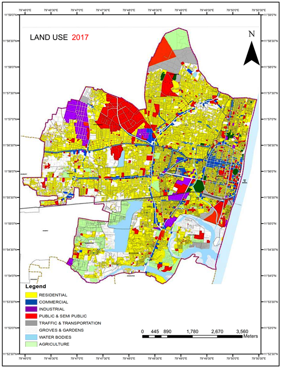
Figure 6. Map for change detection 2017.

Table 1. Land use classification.
Table 2. Overall percentage change in a different class.
Establishment of new high rise building such as mall which occupies a large built-up area consisting of textile trading complex, commercial outlets, recreation centres, hotels and several major multi branded retail outlets have been developing within the urban agglomeration area of the Puducherry City in terms of change detection land use classification as shown in Figure 7. The flow rate of touristor have been increasing from neighbouring states such as Chennai, Bengaluru and Andhra Pradesh to visit Aurobindo Ashram, Auroville, Arikamedu and other beach areas of the East Coastal Zone of Puducherry City.
In view of above, the year-on-year increasing number of vehicles, coupled with inadequate parking infrastructure has made motoring in the city more congested. In peak hours the traffic congestion is at higher rate in the intersections. All the Government head offices, Central Business District (CBD) are located in the centre of the city in boulevard. Hence the people residing in urban and other small and medium town areas need to reach the centre of the city for their requirements. This is one of the main reasons for increase in traffic congestion. The carrying capacities of the existing roads are inadequate to manage the present vehicle population.

Figure 7. Change detection map (1997-2017).
Mandate of rules for parking facilities at commercial complex, seems to have been missed by many multi story buildings. In some of the streets within the Puducherry City, parking on both sides is prohibited yet vehicles queue up due to insufficient of park lots.
Between 1997 and 2017 the population increased to 64.4% while area of building land grew by 76.63%, it required more rate of land development it terms of population growth and it would have a significant impact to provide basic infrastructure facilities. There is an incredible change in agricultural land with negative growth of 6.83% which declined about 33% from 8.88 sq∙km to 6.02 sq∙km between 1997 to 2017. This land has been utilised for urban and built up area like residential, commercial, industrial etc. Among the eight land use classification, grooves and garden cover only 0.73 sq∙km in 2017, while it was about 1.02 sq∙km. The agricultural land decreased from 8.83 sq∙km in 1997 to 6.02 sq∙km in 2017 which indicates a negative trend (Figure 8 & Figure 9).

Figure 8. Change detection.

Figure 9. Percentage change (1917-2017).
5. Conclusions
The present study analyzes the land use/land cover of the Puducherry city from 1997 to 2017 using Remote Sensing and ArC GIS in conjunction with Comprehensive Development Plan and various socio-economic parameters. As far as Puducherry city is concerned, the people from surrounding areas move towards Central Business District (CBD) to fulfill their day to day need and requirements. The rapid growth of population in Puducherry city is about 3.48 millon in 1991 to 5.44 million, in 2011 is one of the main reasons for an increase in the built-up area in Puducherry city. The Government of Puducherry has notified that the whole Puducherry region comes under the Puducherry Planning Area. Puducherry city is one of the educational hubs with good infrastructure facilities and hence people have migrated from rural areas, small and medium town to the main city. Large retailers have set up shops in Puducherry over the years without adequate parking space leading to traffic congestion. Hence this study suggests identifying the growth centres to decentralise facilities and conserve the natural resources. The upcoming building at commercial spaces must provide compulsory parking facilities unless they are located in a vehicle free zone. Paid public parking could also be introduced as in cities. Separate parking spaces have to be created for vehicle, especially two wheelers and four wheelers.
This study suggests that an intensive decrease in agricultural land, accommodation of dense population, consumption of natural resources are the prime challenges and due to these reasons the city would face for future development. Hence the planning policy must be made to regulate the urban growth and enhance the sustainable development in identified growth centres in and around of Puducherry city.
Acknowledgements
The authors are thankful to the Department of Civil Engineering, Pondicherry Engineering College, Indian Remote Sensing Centre, Town and Country Department, Department of Transport, Department of land and records and Department of Census.
Conflicts of Interest
The authors declare no conflicts of interest regarding the publication of this paper.
Cite this paper
Sangaradasse, P. and Eswari, S. (2019) Impact of Urbanisation on Land Use/Land Cover in Puducherry City, India. Journal of Transportation Technologies, 9, 331-341. https://doi.org/10.4236/jtts.2019.93021
References
- 1. Berling-Wolff, S. and Wu, J. (2004) Modeling Urban Landscape Dynamics: A Case Study in Phoenix, USA. Urban Ecosystems, 7, 215-240. https://doi.org/10.1023/B:UECO.0000044037.23965.45
- 2. Grimm, N.B., Grove, J.M., Picket, S.T.A. and Redman, C.L. (2000) Integrated Approaches to Long-Term Studies of Urban Ecological Systems. Bioscience, 50, 571-584. https://doi.org/10.1641/0006-3568(2000)050[0571:IATLTO]2.0.CO;2
- 3. Chadchan, J. and Shankar, R. (2012) An Analysis of Urban Growth Trends in the Post-Economic Reforms Period in India. International Journal of Sustainable Built Environment, 1, 36-49. https://doi.org/10.1016/j.ijsbe.2012.05.001
- 4. Barnes, K.B., Mrogan III, J.M., Roberge, M.C. and Lowe, S. (2001) Sprawl Development: Its Patterns, Consequences, and Measurement. Towson University, Towson.
- 5. Dewan, A.M., Yamaguchi, Y. and Rahman, M.Z. (2012) Dynamics of Land Use/Cover Changes and the Analysis of Landscape Fragmentation in Dhaka Metropolitan. Bangladesh GeoJournal, 77, 315-330. https://doi.org/10.1007/s10708-010-9399-x
- 6. Farooq, S. and Ahmad, S. (2008) Urban Sprawl Development around Aligarh City: A Study Aided by Satellite Remote Sensing and GIS. Journal of the Indian Society of Remote Sensing, 36, 77-88. https://doi.org/10.1007/s12524-008-0008-0
- 7. Haub, C. and Gribble, J. (2011) The World at 7 Billion. Population Bulletin, 66, 1-12.
- 8. Birkmann, J., Welle, T., Solecki, W., Lwasa, S. and Garschagen, M. (2016) Boost Resilience of Small and Mid-Sized Cities. Nature, 537, 605-608. https://doi.org/10.1038/537605a
- 9. Gregorio, A. (2005) Land Cover Classification System: Classification Concepts and User Manual. Food and Agricultural Organization of the United Nations, Rome.
- 10. Lambin, E. (1997) Modeling and Monitoring Land-Cover Change Processes in Tropical Regions. Progress in Physical Geography: Earth and Environment, 21, 375-393. https://doi.org/10.1177/030913339702100303
- 11. Manju, M., Subhan, K.P., Kolli, N., Anurag, K. and Sucheta, P. (2011) Dynamics of Urbanization and Its Impact on Land-Use/Land-Cover: A Case Study of Megacity Delhi. Journal of Environmental Protection, 2, 1274-1283. https://doi.org/10.4236/jep.2011.29147
- 12. Forman, R.T.T. (2014) Urban Ecology: Science of Cities. Cambridge University Press, Cambridge.
- 13. Pawe, C.K. and Saikia, A. (2018) Unplanned Urban Growth: Land Use/Land Cover Change in the Guwahati Metropolitan Area, India. Geografisk Tidsskrift-Danish Journal of Geography, 118, 88-100.
- 14. Im, J., Jensen, J. and Tullis, J. (2008) Object-Based Change Detection Using Correlation Image Analysis and Image Segmentation. International Journal of Remote Sensing, 29, 399-423. https://doi.org/10.1080/01431160601075582
- 15. Herold, M., Scepan, J. and Clarke, C. (2002) The Use of Remote Sensing and Landscape Metrics to Describe Structures and Changes in Urban Land Uses. Environment and Planning A: Economy and Space, 34, 1443-1458. https://doi.org/10.1068/a3496
- 16. Draft Comprehensive Development Plan for Puducherry City (1997) Report Prepared By Town and Country Planning Department, Puducherry.