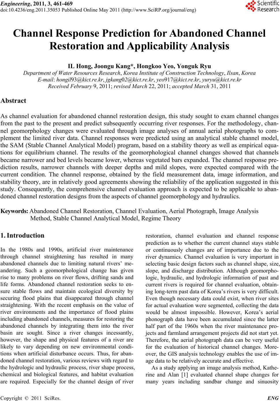
 Engineering, 2011, 3, 461-469 doi:10.4236/eng.2011.35053 Published Online May 2011 (http://www.SciRP.org/journal/eng) Copyright © 2011 SciRes. ENG Channel Response Prediction for Abandoned Channel Restoration and Applicability Analysis IL Hong, Joongu Kang*, Hongkoo Yeo, Yonguk Ryu Department of Water Resources Research, Korea Institute of Construction Technology, Ilsan, Korea E-mail: hongil93@kict.re.kr, jgkang02@kict.re.kr, yeo917@kict.re.kr, yuryu@kict.re.kr Received February 9, 2011; revised March 22, 20 1 1; accepted March 31, 2011 Abstract As channel evaluation for abandoned channel restoration design, this study sought to exam channel changes from the past to the present and predict subsequently occurring river responses. For the methodology, chan- nel geomorphology changes were evaluated through image analyses of annual aerial photographs to com- plement the limited river data. Channel responses were predicted using an analytical stable channel model, the SAM (Stable Channel Analytical Model) program, based on a stability theory as well as empirical equa- tions for equilibrium channel. The results of the geomorphological channel changes showed that channels became narrower and bed levels became lower, whereas vegetated bars expanded. The channel response pre- diction results, narrower channels with deeper depths and mild slopes, were expected compared with the current condition. The channel response, obtained by the field measurement data, image information, and stability theory, are in relatively good agreements showing the reliability of the application suggested in this study. Consequently, the comprehensive channel evaluation approach is expected to be applicable to aban- doned channel restoration designs from the aspects of channel geomorphology and hydraulics. Keywords: Abandoned Channel Restoration, Channel Evaluation, Aerial Photograph, Image Analysis Method, Stable Channel Analytical Model, Regime Theory 1. Introduction In the 1980s and 1990s, artificial river maintenance through channel straightening has resulted in many abandoned channels due to limiting natural rivers’ me- andering. Such a geomorphological change has given rise to many problems on river flows, drifting sands and life forms. Abandoned channel restoration seeks to en- sure stable flows and maintain ecological diversity by securing flood plains that disappeared through channel straightening. With the recent emphasis on the value of river environments and the importance of flood plains including abandoned channels, measures for restoring the abandoned channels by integrating them into the river basin are sought. Since a river changes incessantly, however, the shape and physical features of a river are likely to vary depending on new environmental condi- tions when artificial disturbance occurs. Thus, for aban- doned channel restoration, various reviews with regard to the hydrologic and hydraulic process, river shape process, chemical and biological features, and habitat evaluation are required. Especially for the channel design of river restoration, channel evaluation and channel response prediction as to whether the current channel stays stable or continuously changes are of importance due to the river dynamics. Channel evaluation is very important in selecting basic design factors such as channel shape, size, slope, and discharge distribution. Although geomorpho- logic, hydraulic, and hydrologic information of past and current rivers is required for channel evaluation, obtain- ing long-term past data of Korea’s rivers is very difficult. Even though necessary data could exist, when river sites for actual evaluation were segmented, collecting the data would be almost impossible. However, Korea’s aerial phonograph data have been accumulated since the latter half part of the 1960s when the river maintenance pro- jects and farmland arrangement projects did not start yet. Therefore, the aerial photograph data can be very useful for the evaluation of historical channel changes. More- over, the GIS analysis technology enables the use of im- age data to be relatively accurate and effective. As a study applyin g an image analysis method, Kathe- rine and Alan [1] evaluated channel shape changes for many years including sandbar change and sinuosity 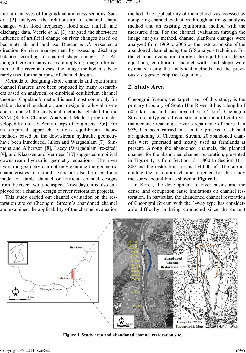 I. HONG ET AL 462 through analyses of longitudinal and cross sections. San- dra [2] analyzed the relationship of channel shape changes with flood frequency, flood size, rainfall, and discharge data. Veerle et al. [3] analyzed the short-term influence of artificial change on river changes based on bed materials and land use. Duncan et al. presented a direction for river management by assessing discharge balance according to channel shape changes [4]. Al- though there are many cases of applying image informa- tion to the river analyses, the image method has been rarely used for the purpose of channel design. Methods of designing stable channels and equilibrium channel features have been proposed by many research- ers based on analytical or empirical equilibrium channel theories. Copeland’s method is used most commonly for stable channel evaluation and design in alluvial rivers and is one of the analytical methods selected for the SAM (Stable Channel Analytical Model) program de- veloped by the US Army Corps of Engineers [5,6]. For an empirical approach, various equilibrium theory methods based on the downstream hydraulic geometry have been introduced. Julien and Wargadalam [7], Sim- mons and Albertson [8], Lacey (Wargadalam, re-cited) [9], and Klaassen and Vermeer [10] suggested empirical downstream hydraulic geometry equations. The river hydraulic geometry can not only examine the geometric characteristics of natural rivers but also be used for a model of stable channel or artificial channel designs from the river hydraulic aspect. Nowadays, it is also em- ployed for a channel design of river restoration projects. This study carried out channel evaluation on the res- toration site of Cheongmi Stream’s abandoned channel and examined the applicability of the channel evaluation method. The applicability of the method was assessed by comparing channel evaluation through an image analysis method and an existing equilibrium method with the measured data. For the channel evaluation through the image analysis method, channel planform changes were analyzed from 1969 to 2006 on the restoration site o f the abandoned channel using the GIS analysis technique. For the channel evaluation through the equilibrium theory equations, equilibrium channel width and slope were estimated using the analytical methods and the previ- ously suggested empirical equations. 2. Study Area Cheongmi Stream, the target river of this study, is the primary tributary of South Han River; it has a length of 60.5 km and a basin area of 615.4 km2. Cheongmi Stream is a typical alluvial stream and the artificial river maintenance reaching a river’s repair rate of more than 97% has been carried out. In the process of channel straightening of Cheongmi Stream, 20 abandoned chan- nels were generated and mostly used as farmlands at present. Among the abandoned channels, the planned channel for the abandoned channel restoration, presented in Figure 1, is from Section 15 + 800 to Section 16 + 800 and the restoration area is 154,000 m2. The site in- cluding the restoration channel targeted for this study measures about 4 km as shown in Figure 1. In Korea, the development of river basins and the dense land occupation cause limitations on channel res- toration. In particular, the abandoned channel restoration of Cheongmi Stream with the 1-way type has consider- able difficulty in being conducted since the current Figure 1. Study area and abandoned c hanne l r e stor ation site. Copyright © 2011 SciRes. ENG 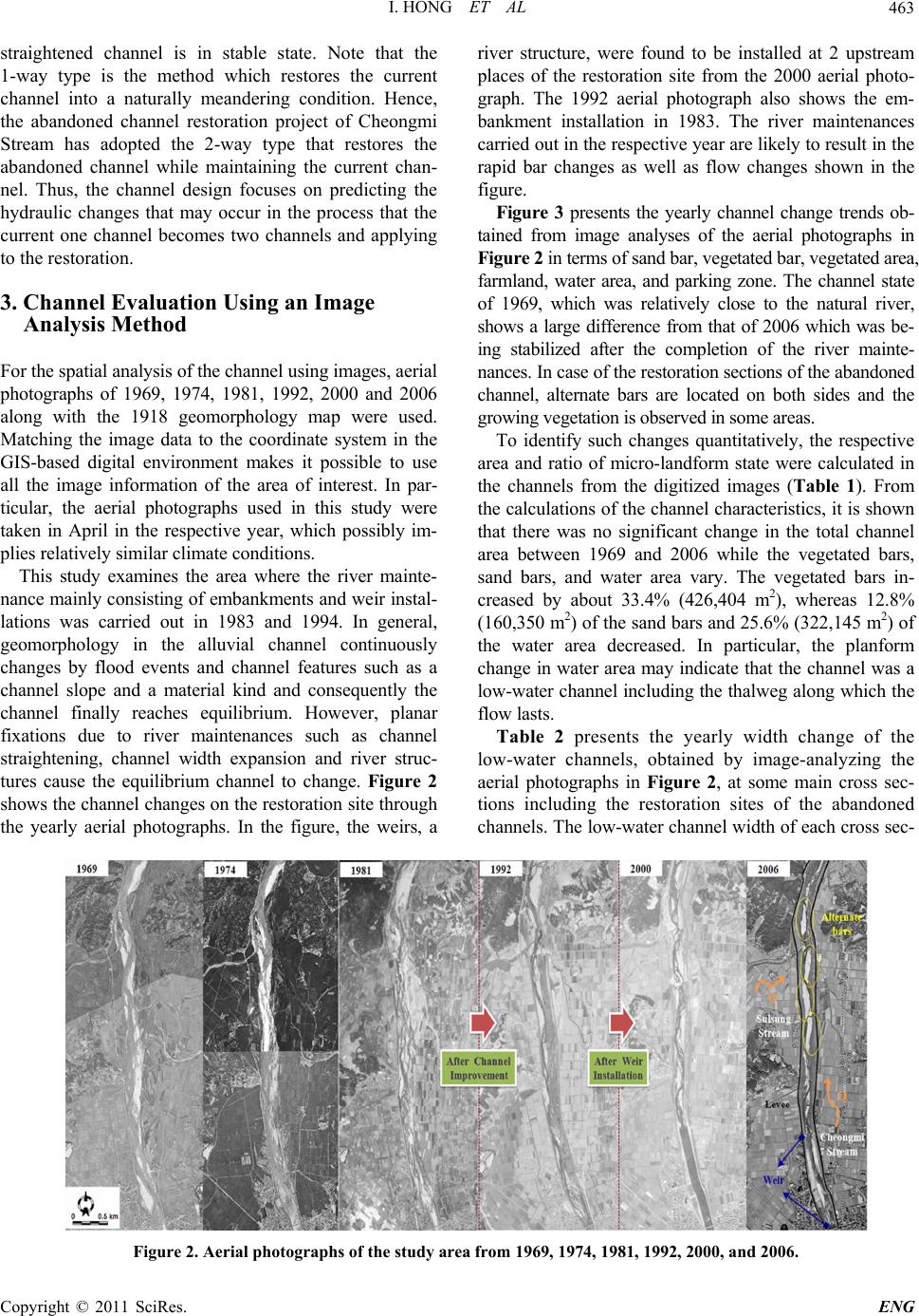 I. HONG ET AL Copyright © 2011 SciRes. ENG 463 straightened channel is in stable state. Note that the 1-way type is the method which restores the current channel into a naturally meandering condition. Hence, the abandoned channel restoration project of Cheongmi Stream has adopted the 2-way type that restores the abandoned channel while maintaining the current chan- nel. Thus, the channel design focuses on predicting the hydraulic changes that may occur in the process that the current one channel becomes two channels and applying to the restoration. 3. Channel Evaluation Using an Image Analysis Method For the spatial analysis of the channel using images, aerial photographs of 1969, 1974, 1981, 1992, 2000 and 2006 along with the 1918 geomorphology map were used. Matching the image data to the coordinate system in the GIS-based digital environment makes it possible to use all the image information of the area of interest. In par- ticular, the aerial photographs used in this study were taken in April in the respective year, which possibly im- plies relatively similar climate conditions. This study examines the area where the river mainte- nance mainly consisting of embankments and weir instal- lations was carried out in 1983 and 1994. In general, geomorphology in the alluvial channel continuously changes by flood events and channel features such as a channel slope and a material kind and consequently the channel finally reaches equilibrium. However, planar fixations due to river maintenances such as channel straightening, channel width expansion and river struc- tures cause the equilibrium channel to change. Figure 2 shows the chann el changes on the restoration site th rough the yearly aerial photographs. In the figure, the weirs, a river structure, were found to be installed at 2 upstream places of the restoration site from the 2000 aerial photo- graph. The 1992 aerial photograph also shows the em- bankment installation in 1983. The river maintenances carried out in the respective year are likely to result in the rapid bar changes as well as flow changes shown in the figure. Figure 3 presents the yearly channel change trends ob- tained from image analyses of the aerial photographs in Figure 2 in term s of sand bar, vegetate d bar, vegetate d area, farmland, water area, and parking zone. The channel state of 1969, which was relatively close to the natural river, shows a large difference from that of 2006 which was be- ing stabilized after the completion of the river mainte- nances. In case of the restoration sections of the abandoned channel, alternate bars are located on both sides and the growing vegetation is observed in some areas. To identify such changes quantitatively, the respective area and ratio of micro-landform state were calculated in the channels from the digitized images (Table 1). From the calculations of the channel characteristics, it is shown that there was no significant change in the total channel area between 1969 and 2006 while the vegetated bars, sand bars, and water area vary. The vegetated bars in- creased by about 33.4% (426,404 m2), whereas 12.8% (160,350 m2) of the sand bars and 25.6% (322,145 m2) of the water area decreased. In particular, the planform change in water area may indicate that the channel was a low-water channel including the thalweg along which the flow lasts. Table 2 presents the yearly width change of the low-water channels, obtained by image-analyzing the aerial photographs in Figure 2, at some main cross sec- tions including the restoration sites of the abandoned channels. The low-water channel width of each cross sec- Figure 2. Aerial photographs of the study area from 1969, 1974, 1981, 1992, 2000, and 2006.  I. HONG ET AL 464 Figure 3. Example of a figure caption. Table 1. Summary of 1969 and 2006 Micro-Landform characteristics in the study channel. Classification Vegetated Bar (m2)Farmland (m2) Sand Bar (m2) Water Area (m2) Parking Zone (m2) Total C ha nne l Ar ea (m2) 1969 251,321 (19.9%) 36,588 (2.9%) 361,329 (28.5%) 616,854 (48.7%) - 1,266,093 (100%) 1974 353,568 (28.2%) 63,019 (5.1%) 222,133 (17.7%) 614,459 (49.0%) - 1,253,179 (100%) 1981 143,280 (11.4%) 130,391 (10.3%) 470,901 (37.4%) 515,119 (40.9%) - 1,259,691 (100%) 1992 752,569 (58.4%) - 298,071 (23.2%) 237,195 (18.4%) - 1,287,836 (100%) 2000 618,707 (47.3%) 26,210 (2.0%) 255,834 (19.5%) 408,285 (31.2%) - 1,309,036 (100%) 2006 677,725 (53.3%) 50,632 (4.0%) 200,979 (15.8%) 294,709 (23.1%) 47 795 (3.8%) 1,271,840 (100%) tion appears to decrease gradually compared to the past. The characteristics of channel planform changes pre- sented in Figure 3. Table 1 and Table 2 show the chan- nel became gradually narrower and the total bars in- creased. As for the bar changes in detail, the sand bars decreased while the vegetated bars increased. The ten- dency of bar change shows the process of vegetation gradually taking root with the fixation of the sand bars. Consequently, the artificial river maintenances show that natural change gradually decreases and only thalweg of the low-water channel changes. 4. Prediction of Stable Channel Using Equilibrium Methods For the channel response prediction, this study employed the previously suggested methods based on both analyti- cal and empirical equilibrium bed theories. This study evaluated the current channel’s stability by using Cope- land’s method [5], one of the mostly used analytical methods, as a basic module for the planned site of Cheongmi Stream’s abandoned channel restoration. Copeland’s method, one of the analytical methods used for SAM of the US Army Corps of Engineers, is most widely used for evaluation and design of stable channels in alluvial rivers [6]. This method is similar to that of Abou-Seida and Saleh [11]. Among 3 unknown variables (channel width, slop e, and dep th of a stab le chann el), an y two ones are calculated first. For the third unknown one, the most suitable solution for design conditions and geomorphological conditions is selected from several solutions by a designer. Copyright © 2011 SciRes. ENG  I. HONG ET AL 465 For the empirical method, the equations of Julien and Wargadalam [7], Simmons and Albertson [8], Lacey (Wargadalam, re-cited) [9], and Klaassen and Vermeer [10] were used and compared. The equations of Julien and Wargadalam, Simmons and Albertson, Lacey, and Klaassen and Vermeer are typical empirical equilibrium bed equations related to downstream hydraulic geometry. 4.1. Stable Channel Prediction Using Analytical Methods The stable channel slope in the restoration site of Cheongmi Stream was calculated using SAM to which Copeland’s method is applied. The input data for the stable channel design used for SAM include the follow- ing: bankfull discharge, Qb = 488 m3/s; specific gravity, G = 2.65; valley slope, Sv = −0.00088; bank side slope, 2.3; bank roughness, 0.03; bed material gradation, d84 = 2.18 mm, d50 = 1.1 mm, d16 = 0.63 mm. For the restoration site of Cheongmi Stream, the cal- culated bottom widths using SAM and the corresponding converted top widths are presented in Table 3. The cal- culation for Cheongmi Stream gives 21 solutions of the stable channel bottom widths ranging from 7.92 m to 160.02 m, the water depths for the bankfull discharge ranging from 2.09 m to 7.61 m, and the energy slopes ranging from 0.000912 to 0.000762. The relationships of the slope with the width and the depth are presented in Figure 4. The conditions for the widths, depths and slopes plotted in Figure 4 mean a theoretically stable state. The figure indicates that a river with a condition falling under the region outside the relation curves could get unstable. The unstable state is expected to be caused by either erosion for the conditions over the relation curves or sedimentation fo r the co nditions und er the rela- tion curve. Figure 4 shows the calculated 21 solutions for the stable channel includin g 1 solu tion with minimum stream power. Table 4 presents the surface curve data of Cheongmi Stream in the current condition calculated using HEC-RAS based on the geomorphological data meas- ured in 2008. Note that the region from Section 15 + 8 to Table 2. Changes in the low flow channel width along Cheongmi Stream. Cross section number Year 15 + 523 16 + 40016 + 507 17 + 517 1969 99.8 108.6 132.8 87.5 1992 46.4 28.8 31.3 35.0 2000 39.4 18.0 53.2 66.3 2006 36.3 13.2 42.3 58.2 Table 3. Stable channel dimensions calculated using the SAM program. Bottom Width (m) Depth (m) Top Width (m) Energy Slope Hyd Raidus (m) Velocity (m/s) Froude Number Bed Regime 7.927.61 42.93 0.000 912 4.21 2.53 0.29Lower 16.156.90 47.89 0.000 688 4.35 2.21 0.27Lower 24.086.20 52.60 0.000 617 4.30 2.05 0.26Lower 32.005.58 57.67 0.000 589 4.16 1.95 0.26Lower 39.935.05 63.16 0.000 579 3.98 1.87 0.27Lower 43.704.8365.92 0.000 580 3.90 1.84 0.27 Lower 48.164.59 69.27 0.000 580 3.77 1.81 0.27Lower 56.084.22 75.49 0.000 587 3.59 1.76 0.27Lower 64.013.90 81.95 0.000 598 3.40 1.71 0.28Lower 71.933.63 88.63 0.000 609 3.23 1.67 0.28Lower 80.163.39 95.75 0.000 623 3.06 1.64 0.28Lower 88.093.18 102.72 0.000 637 2.91 1.61 0.29Lower 96.013.00 109.81 0.000 651 2.78 1.58 0.29Lower 103.942.85 117.050.000 665 2.66 1.55 0.29Lower 112.172.70 124.590.000 680 2.54 1.53 0.30Lower 120.092.57 131.910.000 694 2.43 1.5 0.30Lower 128.022.46 139.340.000 709 2.34 1.48 0.30Lower 135.942.36 146.800.000 723 2.25 1.46 0.30 Lower 144.172.26 154.570.000 737 2.17 1.45 0.31Lower 152.102.17 162.080.000 751 2.09 1.43 0.31Lower 160.022.09 169.630.000 762 2.02 1.41 0.31Lower Section 16 + 8 is the planned area for the abandoned channel restoration. The channel top widths by HEC-RAS is calculated from 158 m to 236 m when a bankfull discharge occurs, which are overestimated compared with the stable channel top widths obtained by the Copeland method. Moreover, in case the abandoned channel restoration is carried out, the channel top widths are expected to have a larger value rather than the stable channel width since newly restored channel widths will be added to the existing channel widths for the total width estimation. Although the depths of the stable channel obtained by SAM range from 2.09 m to 7.61 m, the depths of the channel in current state by HEC-RAS are estimated from 1.52 m to 2.09 m. The current chan- nel slopes are slightly larger than those of the stable channel and the differences are negligible. From the comparisons, the stable channel estimated by SAM is expected to have narrower width, deeper depth and milder slope compared with the current channel condi- tion and the HEC-RAS estimation. In particular, the re- sult that the current channel width is wider than that of the stable channel favorably accounts for why bars de- velop in the current channel. Copyright © 2011 SciRes. ENG  I. HONG ET AL Copyright © 2011 SciRes. ENG 466 4.2. Channel Evaluation Using Empirical 12.2 1ln s h md (5) Equilibrium Bed Equations This study predicted the stable channel width, i.e. equi- librium channel width, of the abandoned channel restora- tion site of Cheongmi Stream using the equilibrium equations, which are suggested by Julien and War- gadalam, Simmons and Albertson, Lacey and Klaassen and Vermeer. where h (m) is the average flow depth, W (m) is the av- erage width, V (m/s) is the average one-dimensional ve- locity, Q (cfs) is the discharge, S is the channel sl ope, τ* is the Shields parameter, ds (m) is the sediment size, and m is the parameter determined from roughly estimated flow depth. Julien and Wargadalam used the concepts of resistance, sediment transport, continuity, and secondary flow to develop analytical hydraulic geometry equations as fol- lows: Simons and Albertson [8] used five sets of data from canals in India and America to develop equations and used the relationship graph of a wetted perimeter with a discharge and a channel width to determine equilibrium channel width. 2566 56156 0.2 mm mm s hQ dS (1) 0.512 2.51PQ (6) 24 5645612 56 1.33 mmmm mm s WQd S (2) where P (ft) is the wetted perimeter. 12 5625622 56 3.76 mmmm mm s VQd S (3) Lacey (from Wargadalam) [9] developed a power re- lationship for determining wetted perimeter based on discharge. 2565564656 *0.121 mmm s Qd S m (4) Table 4. Hydraulic characteri stics of the bankfull discharge condition for Cheongmi Stream. Q (m3/s) River station Depth (m) Energy Slope Velocity (m/s) Top Width (m) Froude Number 16 + 800 1.52 0.000 980 1.38 232.98 0.36 16 + 600 1.65 0.001 258 1.64 179.59 0.41 16 + 507 2.09 0.000 669 1.40 166.97 0.31 16 + 400 2.08 0.000 747 1.48 158.60 0.33 16 + 200 1.79 0.000 898 1.46 186.31 0.35 16 + 000 1.81 0.000 850 1.43 188.78 0.34 488 15 + 800 1.57 0.000 873 1.32 236.08 0.34 Figure 4. Stable channel slope, depth and slope fr om SAM.  I. HONG ET AL 467 0.5 2.667PQ (7) For wide and shallow channels, the wetted perimeter is approximately equal to the width. Klaassen and Vermeer [10] used data from Jamuna River in Bangladesh to develop a width-discharge rela- tionship for braided rivers. 0.53 16.1WQ (8) The input data for the calculation of equilibrium channel width using the empirical equilibrium equations are: the bankfull discharge, Qb = 488 m3/s; the slope be- tween Section 15 + 8 and Section 16 + 8, S = 0.00073; the hydraulic depth of Section 16 + 4, 2.08 m; the bed material size, d50 = 1.1 mm. The equilibrium channel widths of the restoration site of Cheongmi Stream obtained using the downstream hydraulic geometric equation s and equilibriu m bed equa- tions are compared with the current width for the bank- full discharge estimated by HEC-RAS in Figure 5. Three equations except the equation of Klaassen and Vermeer [10] predict the equilibrium channel width to be between 100 m and 145 m, which are smaller than the HEC-RAS channel width, 158.6 m. Note that the equation of Klaas- sen and Vermeer over-predicting the channel width as 428.2 m has regional limitations considering a specific region and considers only a braided channel. Although Section 16 + 4 is the narrowest cross section within the restoration site, the channel width by HEC-RAS is larger than the stable channel width pred icted by the three eq ui- librium equations. 5. Comparison and Discussion The stable channel predictions for the abandoned res- toration site of Cheongmi Stream carried out by both the analytical and the empirical approaches of the equilib- Figure 5. Equilibrium width using downstream hydraulic geometry equations in Cheongmi Stream. rium method are compared with the channel conditions by HEC-RAS in Table 5. Among the methods for the empirical estimation, Klaassen and Vermeer [10] is ex- cluded because of its limitations in application and over- estimation of the top width. Both the channel slope with the min i mu m st re am p o we r est i mate d fr o m SA M an d th e equilibrium slope from Julien and Wargadalam [7] are larger than the current slope, which means the current slope is in stable state. Since the change of Cheongmi Stream into a natural meandering channel for a milder slope is limited due to its current stable condition of slope, it is expected that a weir and a drop structure would supp lement the adju stment o f slope for abando ned channel restoration designs. Moreover, Cheongmi Stream’s current conditions calculated from HEC-RAS, the wider width and shallower depth compared to the predictions from both SAM and empirical equilibrium equations, imply that a narrower channel can be more effective in terms of hydraulics and geomorphologically more stable. The applicability of the comprehensive and comple- mentary assessment using the analytical and empirical equilibrium estimations of a stable channel to an aban- doned channel restoration design was examined through comparisons with the survey data measured in 1983, 1994, and 2004 and the image analysis of the aerial pho- tographs. From the thalweg profiles shown in Figure 6, the bed slope change from 1983 to 2004 was not signifi- cant; the bed level was lowered gradually, however. The average deepest bed level (El.) was 55.6 m in 1983, 54.6 m in 1994, and 54.0 m in 2004. Cross section shapes of Sections 15 + 523, 16 + 507, 17 + 517, and 18 + 515 from 1983 to 2004 are compared in Figure 7. The aver- age channel width of the four cross sections gets narrow by about 30 m from 309.7 m in 1983 to 279.8 m in 2004. From the comparisons of the bed level and the channel width, the channel tends to keep the mild slope and get deeper and wider, which is likely to be a change pattern to a stable chann el. In addition, the wider current ch ann el Table 5. Results of SAM, equilibrium methods, and HEC-RAS for Section 16 + 400. Bankfull Discharge (m3/s) Methods Slope Width (m) Depth (m) SAM 0.000 580 65.924.83 Julien and Wargadalam 0.000 400 143.9- Simons and Albertson - 112.9- Lacey (from Wargadalam ) - 106.7- 488 HEC-RAS (Present Condition) 0.000 747 158.62.08 Copyright © 2011 SciRes. ENG  I. HONG ET AL 468 width rather than the predicted stable channel width ex- plains why the bars around the target channel have de- veloped. The surveyed data as well as the information about the area of the bars and waters from the aerial im- age analysis show the pattern that the channel gets nar- row and vegetation takes root on the subsequently de- veloping bars. The historical channel change observed from the measured data including the survey and aerial photographs supports the channel response prediction by the equilibrium methods. 6. Conclusions This study suggested an assessment method for channel response prediction using an aerial image analysis method and the analytical and empirical equilibrium equations Figure 6. Historical thalweg profiles of the study reach. Figure 7. Cross section changes between 1983 and 2004 for the study reach. Copyright © 2011 SciRes. ENG  I. HONG ET AL Copyright © 2011 SciRes. ENG 469 for a stable channel condition. This approach in this study can be a complementary way to estimate a channel condition and subsequently suggest a plan for channel designs or restoration projects since there has been a need of an alternative channel estimation method due to the lack of past measurement data in Korea. The current channel’s state could be identified using the image analy- sis method that shows macro phenomena on changes in channel geomorphology such as channel width and bar area. Although the image analysis results have a limita- tion, i.e., providing only 2D information, the image analysis method can be a very important method in channel evaluation in a situation wherein sufficient data have not been accumulated. For a stable channel state, the analytical stable channel analysis and empirical equi- librium bed equations provided quantitative values to design the stable and equilibrium channel. Based on findings of change pattern and values of stable channel features, the method is expected to suggest a channel plan from the channel’s geomorphological and hydraulic aspects. In this study, the channel response estimation method was examined by applying it to the abandoned channel restoration site of Cheongmi Stream. From the compari- sons in the channel features between the existing meas- ured data such as the survey data and aerial images and the predictions of the study reach, the change pattern predicted by the suggested method was found to be rela- tively consistent with the measurements; thus confirming the reliability of the applicability. The channel of the restoration site is found to get narrower and deeper, which is a progress into a stable channel. Based on the findings from the comprehensive method, this study proposes designing the abandoned channel to be restored as a narrower one and supplying minimum discharge favorable to the ecosystem since the abandoned channel restoration in the target site plans to use a 2-way type. In addition, since the current channel slope is higher than the equilibrium channel slope, this study also suggested installing slope-adju sting structures such as a drop struc- ture to reach the equilibrium bed. 7. Acknowledgements This study was partially supported by the 2006 Core Construction Technology Development Project (06K SH S- B01) through ECORIVER21 Research Center in KIC- TEP of MLTM KOREA. 8. References [1] F. L. Katherine and W. Alan, “River Channel Planform Change: Software for Historical Analysis,” Geomor- phology, Vol. 29, No. 1-2, 1999, pp. 107-120. doi:10.1016/S0169-555X(99)00009-4 [2] J. W. Sandra, “Medium and Short-Term Channel Plan- form Changes on the River Tay and Tummel, Scotland,” Geomorphology, Vol. 34, No. 3-4, 2000, pp. 195-208. doi:10.1016/S0169-555X(00)00007-6 [3] V. Veerle, M. Armando, G. Gerard, P. Jean, D. Gerd and D. Seppe, “River Channel Response to Short-Term Hu- man-Induced Change in landscape Connectivity in An- dean Ecosystems,” Geomorphology, Vol. 72, No. 3-4, 2005, pp. 340-353. [4] W. Duncan, W. Jeff and B. Louise, “Gravel Extraction and Planform Change in a Wandering Gravel-Bed River: The River Wear, Northern England,” Geomorphology, Vol. 94, No. 1-2, 2008, pp. 131-152. doi:10.1016/j.geomorph.2007.05.003 [5] R. R. Copeland, “Application of Channel Stability Meth- ods—Case Studies,” US Army Corps of Engineers, Wa- terways Experiment Station, Vicksburg, Mississippi, 1994. [6] S. H. Scott, “Application of the SAM Computer Program for Truckee River Stable Channel Analysis,” US Army Corps of Engineers, Coastal and Hydraulics Laboratory, 2006. [7] P. Y. Julien and J. Wargadalam, “Alluvial Channel Ge- ometry: Theory and Applications,” Journal of Hydraulic Engineering, Vol. 121, No. 4, 1995, pp. 312-325. doi:10.1061/(ASCE)0733-9429(1995)121:4(312) [8] D. B. Simons and M. L. Albertson, “Uniform Water Con- veyance Channels in Alluvial Materials,” Journal of the Hydraulics Division, Vol. 68, No. 5, 1960, pp. 33-71. [9] J. Wargadalam, “Hydraulic Geometry of Alluvial Chan- nels,” Colorado State University, Fort Collins, CO., 1993. [10] G. J. Klaassen and K. Vermeer, “Channel Characteristics of the Braiding Jamuna River, Bangladesh,” International Conference on River Regime, Willingford, 18-20 May 1988, pp. 173-189. [11] M. M. Abou-Seida, and M. Saleh, “Design of Stable Al- luvial Channels,” Journal of Hydraulic Research, Vol. 25, No. 4, 1987, pp. 433-446. doi:10.1080/00221688709499261
|