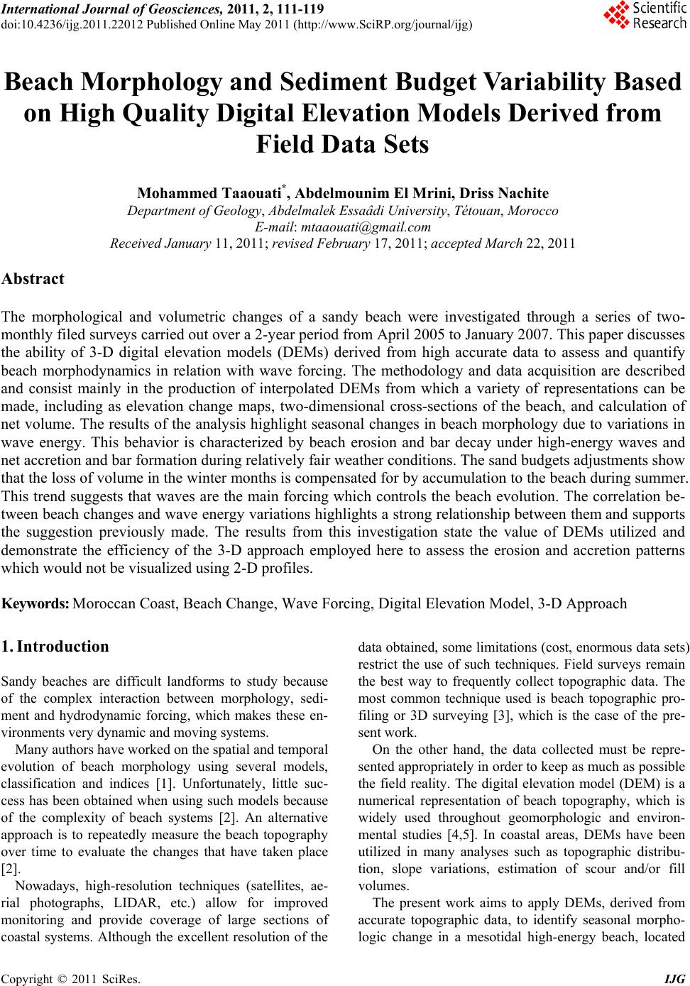
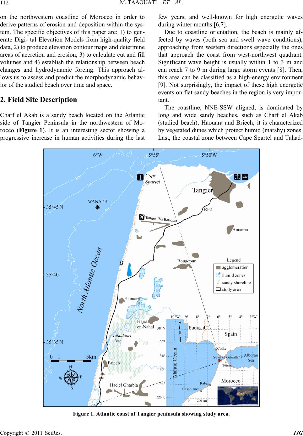
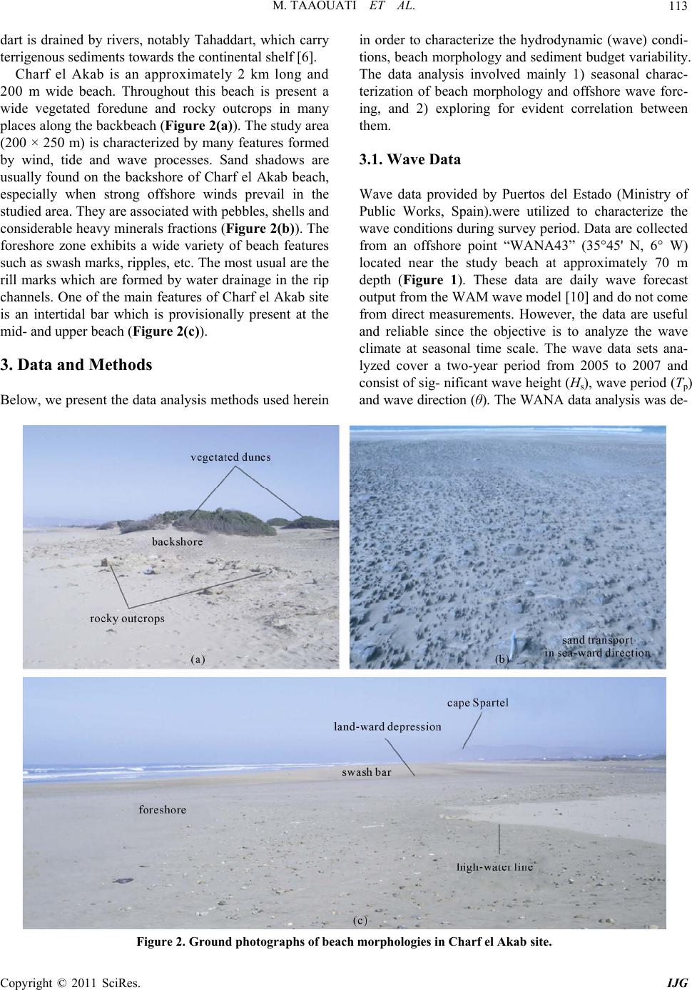
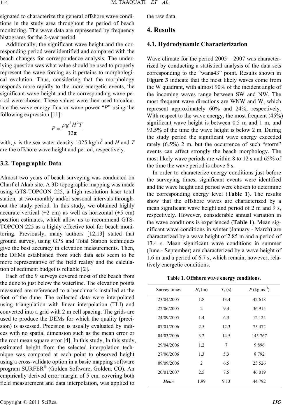
M. TAAOUATI ET AL.
Copyright © 2011 SciRes. IJG
119
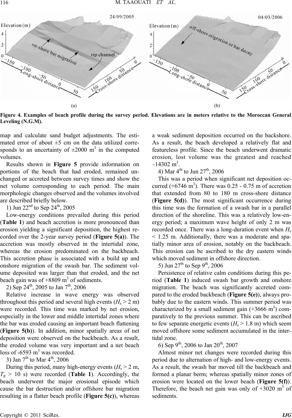
1) Charf el Akab beach presented almost seasonal be-
havior during the study period;
2) this trend consisted in net accretion during low- en-
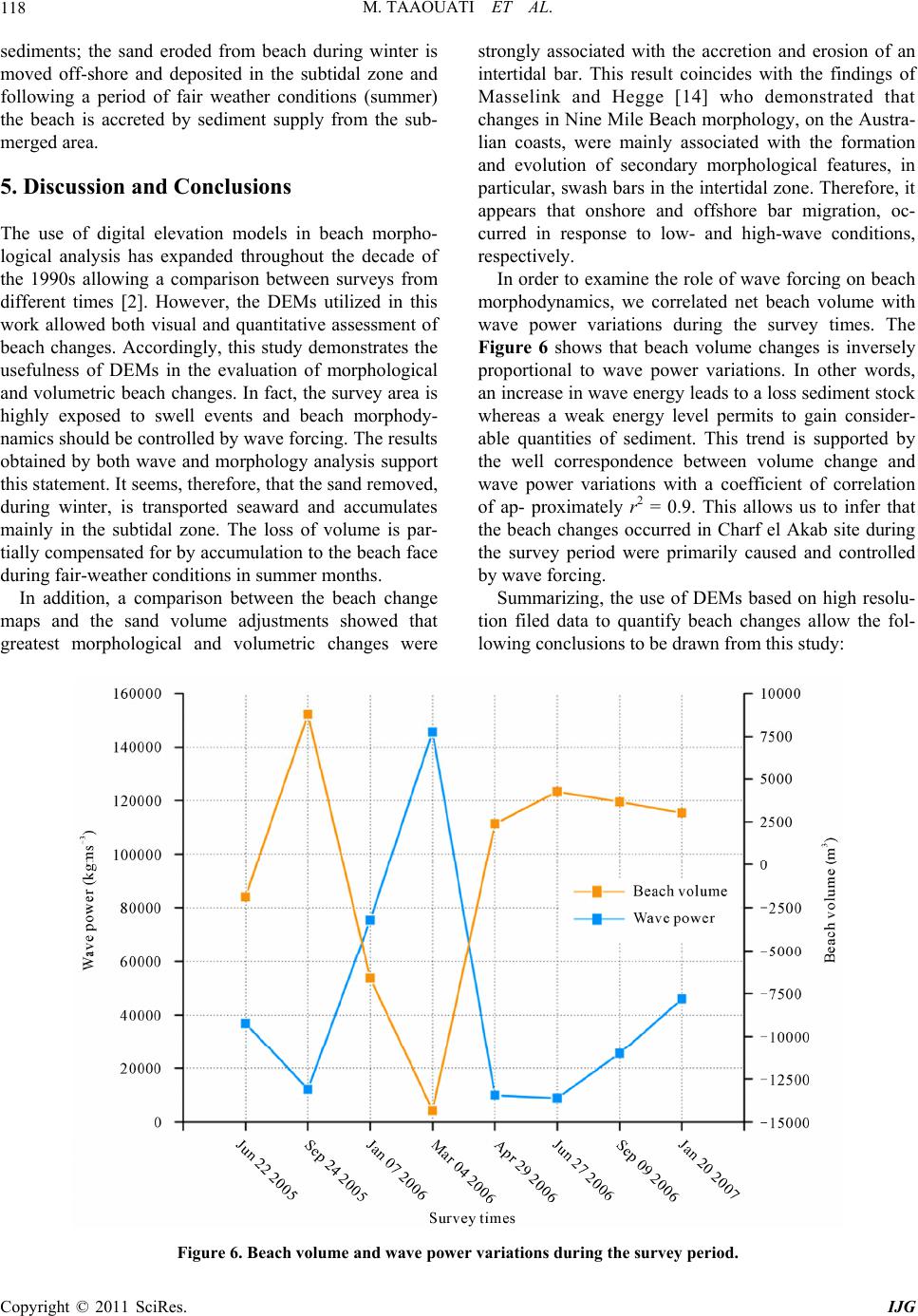
ergy conditions (summer) and beach erosion and flatten-
ing due to high wave energy in winter months;
3) the sediment budget variations were found to be
strongly influenced by seasonal changes in wave energy;
and
4) the 3-D DEM employed here is valuable tool with
which morphological and volumetric changes can be
clearly visualized and quantified.
Finally, this investigation presents an effective method
of determining beach accretion and/or erosion from
high-resolution spatial data which enables accurate
three-dimensional DEMs production. The results from
the present work support this suggestion since the vol-
ume change calculated from DEMs, were highly corre-
lated to variations in wave forcing. These dynamics
would not be identifiable using two-dimensional profiles
and this em- phasizes the value of the three-dimensional
DEMs uti- lized in this study.
6. Acknowledgements
This work was funded by the Moroccan PROTARS III
D16/07 program research. The principal author was
sponsored by a PhD studentship provided by the Na-
tional Center for Scientific and Technical Research of
Morocco. Authors are grateful to the anonymous re-
viewers for their constructive remarks and suggestions
for improvement.
7. References
[1] M. Ortega-Sánchez, et al., “Relation between Beachface
Morphology and Wave Climate at Trafalgar Beach (Cádiz,
Spain),” Geomorphology, Vol. 99, No. 1-4, 2008, pp.
171-185.
[2] B. D. Andrews, P. A. Gares and J. D. Colby, “Techniques
for GIS Modeling of Coastal Dunes,” Geomorphology,
Vol. 48, No. 1-3, 2002, pp. 289-308.
doi:10.1016/S0169-555X(02)00186-1
[3] G. Anfuso, J. A. Martínez del Pozo, D. Nachite, J. Benavente
and A. Macias, “Morphological Characteristics and Med-
ium-Term Evolution of the Beaches between Ceuta and
Cabo Negro (Morocco),” Environmental Geology, Vol.
52, No. 5, 2007, pp. 933-946.
doi:10.1007/s00254-006-0535-3
[4] V. Chaplot, F. Darboux, H. Bourennane, S. Leguédois, N.
Silvera and K. Phachomphon, “Accuracy of Interpolation
Techniques for the Derivation of Digital Elevation Mo-
dels in Relation to Landform Types and Data Density,”
Geomorphology, Vol. 77, No. 1-2, 2006, pp. 126-141.
doi:10.1016/j.geomorph.2005.12.010
[5] G. L. Heritage, D. J. Milan, A. R. G. Large and I. C.
Fuller, “Influence of Survey Strategy and Interpolation
Model on DEM Quality,” Geomorphology, Vol. 112, No.
3-4, 2009, pp. 334-344.
doi:10.1016/j.geomorph.2009.06.024
[6] F. Duplantier and P. Lesueur, “Les Sables du Littoral
Atlantique Nord-Marocain: Origines et Mode de Mise en
Place [Sand on the North-Moroccan Atlantic Coast:
Origins and Depositional Modes],” Bulletin de l’Institut
Géologique du Bassin d’Aquitaine, Vol. 33, 1983, pp.
5-24.
[7] P. Cirac, A. D. Resseguier and O. Weber, “Situation Cou-
rantologique et Hydrologique Sur le Plateau Continental
Atlantique Nord-Marocain: Mission Géomar II [Hy-
drological structure on the North Atlantic Moroccan Shelf:
Cruises Géomar II],” Bulletin de l’Institut Géologique du
Bassin d’Aquitaine, Vol. 46, 1989, pp. 81-95.
[8] E. B. Jaaidi and P. Cirac, “La Couverture Sédimentaire
Meuble du Plateau Continental Atlantique Marocain Entre
Larache et Agadir [The soft Sedimentary Cover of the
Moroccan Atlantic Continental Shelf between Larache
and Agadir],” Bulletin de l’Institut Géologique du Bassin
d’Aquitaine, Vol. 42, 1987, pp. 33-51.
[9] M. Taaouati, D. Nachite, J. Benavente and A. E. Mrini,
“Seasonal Changes and Morphodynamic Behavior of a
High-Energy Mesotidal Beach: Case Study of Charf el
Akab Beach on the North Atlantic Coast of Morocco,”
Environmental Earth Sciences, submitted for publication,
2011. doi: 10.1007/s12665-011-0937-8
[10] H. Günther, S. Hasselmann and P. A. E. M. Janssen, “The
WAM Model Cycle 4 (Revised Version),” Technical Re-
port, Deutsches Klima Rechenzentrum, Hamburg, 1992.
[11] USACE, “Coastal Hydrodynamics,” Coastal Engineering
Manual, No. 1110-2-1100 (Part II), United States Army
Corps of Engineers, Vicksburg, 2008, p. 608.
[12] D. C. Masson, C. Gurney and M. Kennett, “Beach To-
pography Mapping—A Comparison of Techniques,”
Journal of Coastal Conservation, Vol. 6, No. 1, 2000, pp.
113-124.
[13] J. D. Huang, D. W. T. Jackson and J. A. G. Cooper,
“Morphological Monitoring of a High Energy Beach
System Using GPS and Total Station Techniques, Run-
kerry, Co. Antrim, Northern Ireland,” Journal of Coastal
Research, Vol. 36, No. 36, 2002, pp. 390-398.
[14] G. Masselink and B. Hegge, “Morphodynamics of Meso-
and Macrotidal Beaches: Examples from Central Queens-
land, Australia,” Marine Geology, Vol. 129, No. 1-2, 1995,
pp. 1-23. doi:10.1016/0025-3227(95)00104-2