Journal of Geographic Information System
Vol.4 No.1(2012), Article ID:17059,4 pages DOI:10.4236/jgis.2012.41005
Grayscale Mapping of Historically Irrigated Lands Using GIS
Consulting Engineer, Former State of New Mexico State Engineer, Santa Fe, USA
Email: thomas_turney@comcast.net
Received October 15, 2011; revised November 28, 2011; accepted December 19, 2011
Keywords: GIS; Geo-Referencing; Images; Water Rights; Irrigation; Area Computations; Grayscale Mapping
ABSTRACT
This document describes the use of grayscale mapping and GIS for identification of historical irrigated lands. Historical irrigated lands form the basis for water rights—a private property right in New Mexico that is bought and sold on the open market. Identification of irrigated land on historical photography is both a science and an art. Grayscale mapping of historic black and white photographs can aid in the identification of irrigated lands. GIS allows historical images to be geo-referenced and area computations to be performed on polygons that define the irrigated lands.
1. Introduction
Water in New Mexico is scarce. Water can only be used if it has a water right. Water rights in New Mexico are private property rights which can be held, bought or sold on the open market. Water rights are based upon the historical beneficial use of water, such as the use of water for agricultural purposes. Historical aerial photographs can be used to aid in the determination of existing and prior irrigation. Thousands of photographs, taken over time, are available of New Mexico lands from numerous public and private sources.
Irrigated crops can be differentiated from natural undisturbed lands by shape, tone, texture, shadow, association, pattern, and color. The photographs are taken from a perspective view and have geometric errors and cannot be used as the basis for accurate measurements. Interpretation of the photos can be controversial in both administrative hearings and in court proceedings and can result in the loss of water right.
Geo-referencing of the photos is mandatory if the photos are to be used to provide for accurate measurement of the area on an irrigated crop. Grayscale conversion of the black and white image can result in cultivated and noncultivated lands being more easily differentiated.
As a result of identifying irrigated lands, water right claimants may be able to prove that they indeed are the owner of a water right.
2. Geo-Referencing
2.1. Acquisition of Imagery
Acquisition of dated imagery is available from numerous public and private sources. The earliest imagery dates back to 1935, and imagery for many following years is available. Most of the imagery is of a generally high quality. In 2005, the State of New Mexico developed digital ortho-photography for the entire state. For greater accuracy, tagged imaged file format (tiff) image files should be acquired.
2.2. Referencing Image to Geographic Location
The photographic images are not actually a true map of the earth’s surface below. Instead, the photos are a perspective view. Because of the way the photos are taken, they have geometric errors. In rolling terrain, image displacement is negligible only near the center of the photograph. Changes in ground elevation within the photograph area cause continuous change in the scale of the photograph. The tilt of the aircraft as it flies over the area also affects the scale. As a result, the photographs cannot be used as a basis for accurate measurements.
The imagery must be geo-referenced using ground control points (GCP’s). Ortho-rectified photos produced by either the United States Geologic Survey or the State of New Mexico can be used as the basis of GCP’s. GCP’s can be topographic features such as distinct geologic features, old roads or railroad tracks that have remained unchanged over the years, or historical survey lines. The more dispersed the GCP’s are, the more reliable the georeferencing will be [1].
Once geo-referenced, the imagery will fit within the New Mexico Public Land Survey System (PLSS) established in 1855 by the United States Surveyor General. The PLSS has been used in water right filings filed with the New Mexico State Engineer for over a hundred years.
After geo-referencing, a polygon to be drawn around the perimeter of a crop and the irrigated area can be calculated.
3. Grayscale Mapping of Black and White Photos
3.1. Evolving Process
Conversion of grayscale to color has been an evolving process. In the 1960’s, much early work was done mapping grayscale x-rays of the human brain using a process called multispectral analysis. Through the process, shades of gray were turned into a striking pattern on many hues that simplified x-ray interpretation and allowed new understanding of how the human brain worked [2]. Personal computers have now made grayscale mapping affordable and relatively easy. Popular photo-editing programs can easily execute grayscale mapping [3].
3.2. Conversion of Grayscale Photos to Distinctive Colors
Historical photographs are typically black and white images. Black and white photos can be seen on a computer screen as a grayscale image. The images are actually a grayscale gradient that is composed exclusively of shades of grey, varying from black at the strongest intensity to white at the weakest.
A digital image processing system allows a grayscale photo to be mapped and converted to a distinctive color. As an example, a unique shade of grey in the grayscale image can be digitally assigned a specific color in the red, green, blue (RGB) color palette. A stong black could be assigned a red color and and a weak grey could be assigned a blue color. Then, after assignment, all the different shades of grey can be mapped as separate colors. The processing makes certain features stand out in a more vivid color. The grayscale mapped image is created as a separate layer. It can be easily turned off and on. The processing only enhances what is already visibly recorded; it does not change or add anything new to the photograph.
3.3. Example of Grayscale Mapping
Figure 1 depicts a black and white aerial photograph of irrigated lands taken in 1947. Figure 2 shows the same photograph after grayscale mapping.
As can be seen, the black and white photograph is now composed of a series of contrasting colors, making the photograph more readable by distinguishing between very subtle tones of grayscale tones, allowing the photograph to be used more effectively to distinguish between different land cover types.
4. Identification of Irrigated Lands
Identification of irrigated lands is done by examining both the black and white and grayscale mapped photographs. Standard identification characteristics need to be used. These include size and shape of an object, shadows, tone and color, texture, and pattern [4]. Farming activities are clearly visible in Figures 1-2. Row planting of crops is visible. The dark objects on the right side of photograph are full leafed trees and their shadows. An irrigation lateral runs along the right side, under the trees.
5. Comparison of Grayscale Mapped Images to Color Infrared Aerial Photos
5.1. Color Infrared Photos
Beginning in the 1970’s, federal agencies began to photograph using color infrared (CIR) film. This type of photograph is particularly useful in vegetation studies. The human eye can see a particular part of the electromagnetic band of radiation known as visible light. Above the visible light spectrum is the infrared portion.
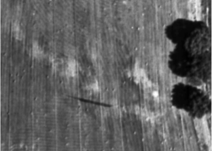
Figure 1. Black and white aerial photograph.
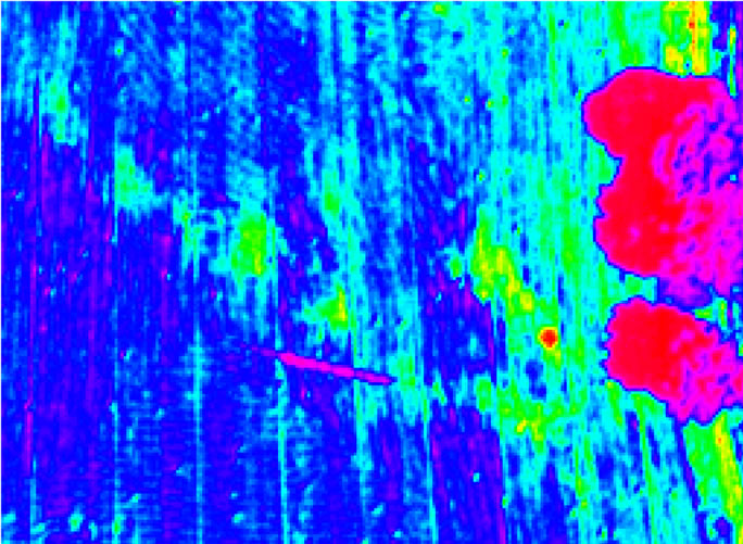
Figure 2. Grayscale mapped aerial photograph.
CIR photography, when available, is frequently a preferred alternative in vegetative studies. The most obvious characteristic of CIR films is the distinctive pink to magenta coloring of most live and healthy vegetation. Almost all surface features distinguishable with B & W or natural color film can also be distinguished with CIR reproductions [5]. This photography does not capture ambient temperature variation, as is the case with other types of thermal imaging.
CIR photos are useful in determining the status of plant growth. As crops emerge after planting and germination, they present leafy growth above the natural soil. In the early stages of growth, this leafy growth is barely detectable on ordinary photography—but it can be seen on a CIR photograph as a light pink. As the crop develops and grows, its leaves begin to spread, covering the bare soil. Depending upon the specific crop and the method of cultivation, linear patterns of rows from the planting process may be visible. As the crop continues to reach full maturity and cover the soil below, the field will appear as bright red. After maturity, plant growth will slow or stop. Plant tissues begin to lose moisture, and can be seen in CIR photos as they attain a lighter color—often a greyish or greenish cast.
5.2. Grayscale Mapped Photos
In the absence of CIR photography, grayscale mapped photography can aid in irrigation studies. Figure 3 shows a black and white photograph of irrigated lands along the Rio Grande. Figure 4 shows a CIR photograph and Figure 5 shows a grayscale mapped photograph of the same lands.
Row cropping patterns are distinctly shown in the irrigated fields. Crops in various stages of the growing season can be observed. Emerging growth is seen at A. Water is flowing into a field at B. A field in a development and growth phase is seen at C.
A fully mature crop is seen at D. A dense growth of salt cedar trees is shown at E. A water supply ditch is seen at F and a drainage ditch at G. The Rio Grande, a major river in New Mexico, is shown at H. Table 1 details the comparison in more detail.
6. Canyons and Lands Rapidly Rising Out of a Valley
Irrigated lands that are located in the bottom of steep canyons or are located in a level valley that has lands that rise rapidly at the valley’s edge can present unique challenges for interpretations of grayscale mapping. Rapidly rising lands can include heavy growths of trees, scattered sagebrush, or exposed rock formations can contain an abundance of dark shadows or heavy batches of light colors, which when grayscale mapped, can detract from interpretation of irrigated lands. Where these topographic conditions exist, it may be advantageous to first define the limits of the level valley floor and then do grayscale mapping only in these defined areas.
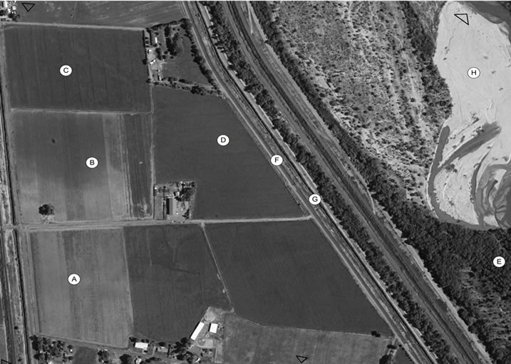
Figure 3. Black and white photo of irrigated lands.
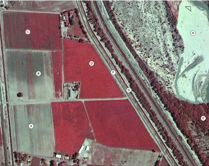
Figure 4. CIR Photo of irrigated lands.
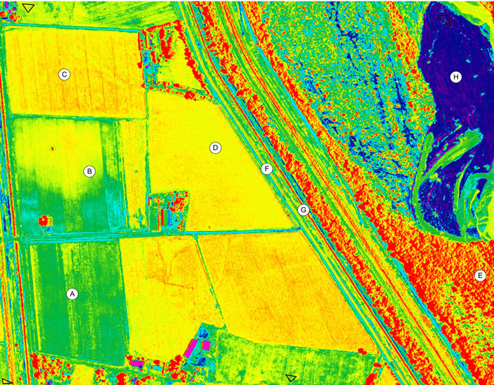
Figure 5. Grayscale mapped photo of irrigated lands.

Table 1. Comparison of characteristics of photos.
7. Conclusions
Water rights in New Mexico are a private property right. Water rights are based upon the historical beneficial use of water, such as being used for agricultural purposes. Historical aerial photographs can be used to aid in the determination of existing and prior irrigation. The are thousands of black and white aerial photographs of crop land available, many of which date back to 1935.
Interpretation of the photos can be controversial in both administrative hearings and in court proceedings and can result in the loss of water right.
Geo-referencing of the photos allows a polygon to be drawn around the perimeter of a crop that area to be accurately calculated.
Grayscale conversion of the black and white image can result in cultivated and non-cultivated lands being more easily differentiated using standard shape, tone, texture, shadow, association, pattern, and color interpretation techniques. Grayscale mapping only enhances what is already visibly recorded; it does not change or add anything new to the photograph.
As a result of identifying irrigated lands, water right claimants may be able to prove more definitely in court proceedings that they indeed are the owner of a water right.
REFERENCES
- ERDAS, “ERDAS Field Guide,” 4th Edition, ERDAS, Inc., Atlanta, 1997, p. 312.
- Time Life, “The Camera,” Time Life Books, New York, 1970, p. 52.
- L. Snider, “Photoshop CS5, the Missing Manual,” O’Reilly Media, Inc, Sebastopol, 2010.
- American Society of Photogrammetry, “Manual of Photographic Interpretation,” American Society of Photogrammetry, Washington DC, 1960, pp. 100-104.
- Bureau of Land Management, “Aerial Photography Archives,” 2011. http://www.blm.gov/nstc/aerial/index.html