Paper Menu >>
Journal Menu >>
 Wireless Sensor Network, 2011, 3, 117-120 doi:10.4236/wsn.2011.34013 Published Online April 2011 (http://www.SciRP.org/journal/wsn) Copyright © 2011 SciRes. WSN A Practical Solution for Location Estimation in Manually Deployed Wire less Sensor Networks Om Prakash Sahu1, Tarun Dubey2 1Department of Electronics and Communication Engineering, National Institute of Technology, Kurukshetra, India 2Department of Electronics and Communication Engineering, Invertis University, Bareilly, India E-mail: ops_nitk @ yahoo .co.in, tarundubey79@ yahoo.co.in Received February 15, 2011; revised March 9, 2011; accepted March 15, 2011 Abstract This paper addresses the existing researc h and adds another aspect o f functionality by incorporating pertinent sensor nodes to provide a dynamic location discovery and estimation. The software used provides an easy gra- phical user interface to visualize a particular location in accordance with geographical latitude and longitude. A simple real time location estimation technique is worked out for wireless sensor networks based on manual deployment of sensors. The proposed scheme finds more efficient solutions with less quantity of sensors as compared to existing deployment schemes. The set up is evaluated exclusively in real environments using IRIS sensor nodes supported by a global positioning system module to provide visualization of an outdoor location. The results are offered by Google Earth application. Keywords: Wireless Sensor Network (WSN), Global Positioning System (GPS), Localization, Sensor Node, IRIS Sensor 1. Introduction Wireless sensor networks have been identified as one of the most prominent technologies for the 21st century [1]. With upcoming advancements, sensor networks find mor e prosperous grounds to spread in areas where traditional networks fail or are inadequate. They find applications in a variety of areas such as climate monitoring, military use, industry and sensing information from inhospitable locations. Sensor networks are also being used for condi- tional based maintenance, surveillance, computer augmen- tation and inventory tracki ng. M a ny ot her appl ications are yet to appear when the technology will become more widely available. Unlike other networks, sensor networks depend on deployment of sensors over a physical loca- tion to fulfill a desired task. Dense deployments imply the use of hundreds or thousands of sensor nodes in small areas with tight coupling within their environments to ensure effective coverage range in a geographical field. Sensor networks also have various computational con- straints like range management, topology selection, power consumption and node localization. Although a lot of re- search is being conducted, there are several open issues for sensor networks such as signal processing [2], dep- loyment [3], operating cost, localization and location es- timation, since the potential for sensor networks in diverse fields has been realized, various software frameworks are being developed to make deployments relatively easy in terms of configuration, maintenan c e and usability. In this paper we present a solution for estimating the location of sensor nodes in a manually framed WSN by using Mote View 2.0.1F software. The software has a complete computational s tack and provides a reliable I R I S sensor platform for monitoring the location of the ma- nually placed nodes in terms of latitude and longitude values. The software architecture provides a customized application with minimum errors. The nodes are executed on a computer through a gateway connected to it. The system is also equipped with Google Earth application for enabling visualization. The IRIS sensor nodes have open access to the out- door environment as they are placed manually on a roof top of a building; the exact location of the building or site is obtained in terms of relative latitude and longitude. In- door applications are not successful as the system re- quires massive optimization to minimize performance de- gradation due to walls and other objects found in indoor environments because of the use of a GPS device. This paper strongly focuses on localization and suggests a sim- ple solution to localize sensors in a manually deployed 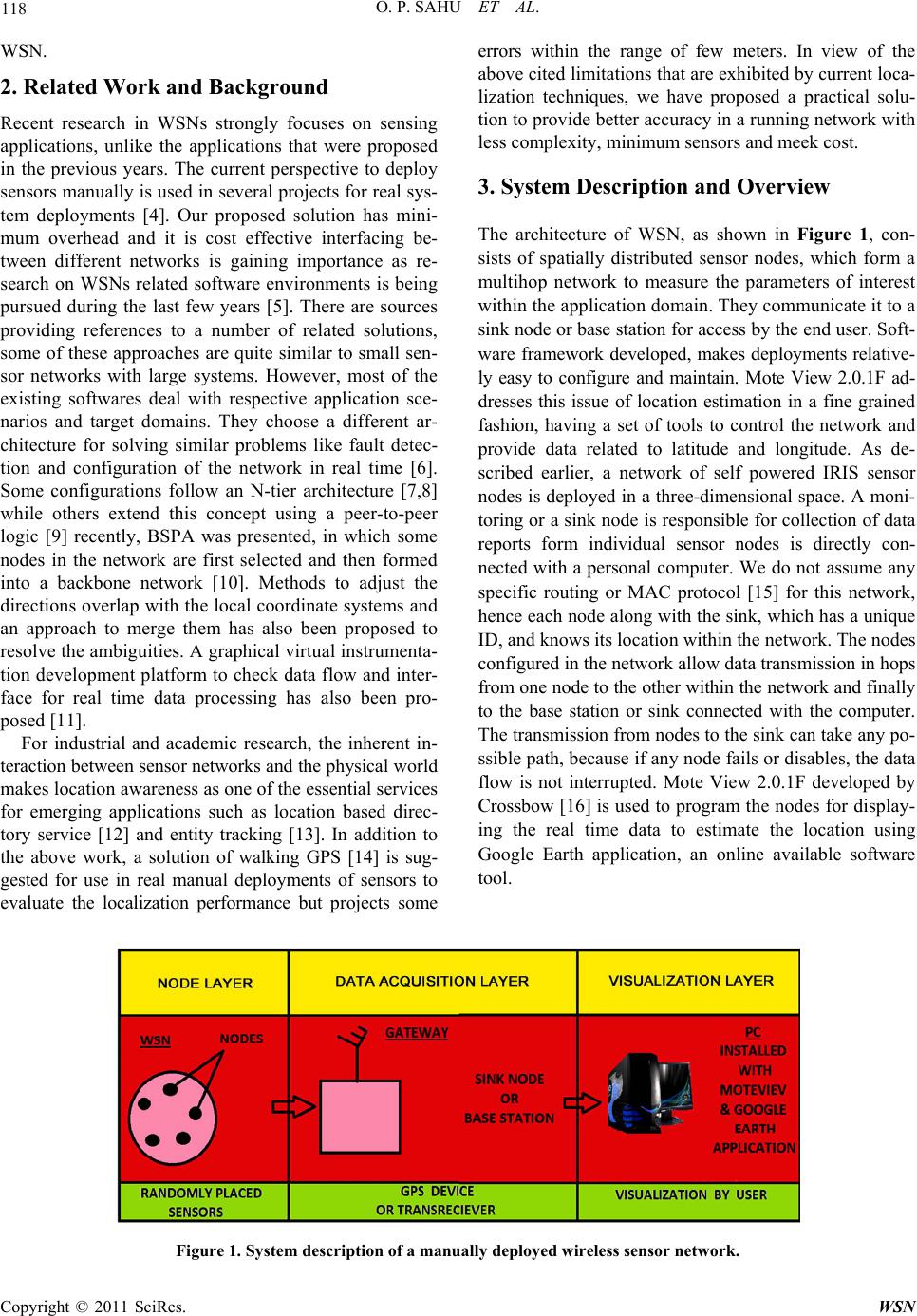 O. P. SAHU ET AL. Copyright © 2011 SciRes. WSN 118 WSN. 2. Related Work and Background Recent research in WSNs strongly focuses on sensing applications, unlike the applications that were proposed in the previous years. The current perspective to deploy sensors manually is used in several projects for real sys- tem deployments [4]. Our proposed solution has mini- mum overhead and it is cost effective interfacing be- tween different networks is gaining importance as re- search on WSNs related software environments is being pursued during the last few years [5]. There are sources providing references to a number of related solutions, some of these approaches are quite similar to small sen- sor networks with large systems. However, most of the existing softwares deal with respective application sce- narios and target domains. They choose a different ar- chitecture for solving similar problems like fault detec- tion and configuration of the network in real time [6]. Some configurations follow an N-tier architecture [7,8] while others extend this concept using a peer-to-peer logic [9] recently, BSPA was presented, in which some nodes in the network are first selected and then formed into a backbone network [10]. Methods to adjust the directions overlap with the local coordinate systems and an approach to merge them has also been proposed to resolve the ambiguities. A graphical virtual instrumenta- tion development platform to check data flow and inter- face for real time data processing has also been pro- posed [11]. For industrial and academic research, the inherent in- teraction between sensor networks and the physical world makes location awareness as one of the essential services for emerging applications such as location based direc- tory service [12] and entity tracking [13]. In addition to the above work, a solution of walking GPS [14] is sug- gested for use in real manual deployments of sensors to evaluate the localization performance but projects some errors within the range of few meters. In view of the above cited limitation s that are exhibited by curren t loca- lization techniques, we have proposed a practical solu- tion to provide better accuracy in a running network with less complexity, minimum sensors and meek cost. 3. System Description and Overview The architecture of WSN, as shown in Figure 1, con- sists of spatially distributed sensor nodes, which form a multihop network to measure the parameters of interest within the application domain. They communicate it to a sink node or base station for access by the end user. Soft- ware framework developed, makes deployments relative- ly easy to configure and maintain. Mote View 2.0.1F ad- dresses this issue of location estimation in a fine grained fashion, having a set of tools to control the network and provide data related to latitude and longitude. As de- scribed earlier, a network of self powered IRIS sensor nodes is deployed in a three-dimensional space. A moni- toring or a sink node is responsible for collection of data reports form individual sensor nodes is directly con- nected with a personal computer. We do not assume any specific routing or MAC protocol [15] for this network, hence each node along with the sink, which has a unique ID, and knows its location within the network. The nodes configured in the network allow data transmission in hops from one node to the other within the network and finally to the base station or sink connected with the computer. The transmission from nodes to the sink can take any po- ssible path, because if any node fails or disables, the data flow is not interrupted. Mote View 2.0.1F developed by Crossbow [16] is used to program the nodes for d isplay- ing the real time data to estimate the location using Google Earth application, an online available software tool. Figure 1. System desc r i ption of a manually deployed wireless sensor network.  O. P. SAHU ET AL. Copyright © 2011 SciRes. WSN 119 4. Performance Evaluation and Deployment A self-powered IRIS sensor node consists of a mote (processor and radio) and a sensor board, programmed with a unique node ID, is enclosed in casings and physi- cally placed at different locations. A laptop or a personal computer interfaced to gateway (MIB520) provides data connectivity to the server through a port. The IRIS sen- sor platform provides a wider coverage area, low power consumption and better optimization for several other applications and is based on IEEE 802.15.4 compliant radios. With an internet connection available, the user can control the system remotely from any location as the nodes are programmed and capable to transmit message packets with a header. The program runn ing on the serv- er collects and displays information of interest to th e user through a wireless link. In order to achiev e real time live data from sensor nodes, the base station has an inbuilt GPS antenna to transmit the real time informatio n of lati- tude and longitude points of the nodes placed on the roof- top of the building. The gateway also allows bidirection- al communication to organize the current information of a specific geographic location (longitude and latitude). To visualize the location in a 3D space, altitude can also be incorporated as a third parameter but is not automati- cally generated by the software under use, since most environments use 2D representations, due to the advan- tage of simultaneous display and network spanning across individual buildings. 5. Experimental Results The Mote View platform [17] enabled to administer the nodes in terms of specific values for latitude and longi- tude. The deployed IRIS sensor motes with sensing modalities monitored the exact geographical location of the individual building in terms of relative positions for latitude as 28˚29'2217" N and longitude as 79˚49'4267" E. The specific location of the site in instantaneous time span and spatial form was correctly visualized with Google Earth application through the site’s satellite im- age with live data. The satellite image of the site where the w ireless sensor n etwork was tested can be seen in Fi- gure 2. A perfect match between the deployment loca- tion and relative geographical position was observed. However localization errors are not provided due to ir- regular deployments and device limitati ons. 6. Conclusions and Future Scope of Work The technique to deploy sensor nodes manually is cur- rently used in several projects, and there are scenarios of real system deployments, where manual deployment is the only solution. Results show that the deployed nodes estimate their relative latitude and long itude position s for a reference point. The average localization error is mainly due to the limitations of the devices used, because for lo- cation information, the nodes completely rely on the glo- bal positioning system and localizing themselves in the middle of their proximate placements or reference points. Figure 2. Screen shot image of the s ite obtained through Google Earth application.  O. P. SAHU ET AL. Copyright © 2011 SciRes. WSN 120 In future, performance evaluation and scalability will be done through simulation. The experience from the cur- rent deployment of the sensors can be used further to address the aerial deployment. Considering the rate, alti- tude, and trajectory of sensor nodes the actual location information at the time of initial deployment, can also be obtained using our solution, giving a starting point to- wards a better and precise localization scheme. The au- thors are working towards making it more common and adaptable for other user communities also. 7. Acknowledgements The authors would like to acknowledge the support and assistance of Electronics and Communication Engineer- ing Departments at National Institute of Tech nolog y, Ku- rukshetra and Invertis University, Bareilly. 8. References [1] D. Culler, D. Estrin, and M. Srivastava, “Overview of Sensor Networks,” IEEE Computer, Vol. 37, No. 8, 2004, pp. 41-49. [2] G. J. Pottie and W. J. Kaiser, “Embedding the Internet: Wireless Integrated Network Sensors,” Communications of the ACM, Vol. 43, No. 5, 2000, pp. 51-58. doi:10.1145/332833.332838 [3] Y. Xu, J. Heidemann and D. Estrin, “Geography In- formed Energy Conservation for Ad Hoc Routing,” Pro- ceedings of the 7th ACM/IEEE Annual International Conference on Mobile Computing and Networking, Italy, 16-21 July 2001, pp. 70-84. [4] I. Chatzigiannakis, G. Mylonas and S. Nikoletseas, “50 Ways to Build your Application: A Survey of Middle- Ware and Systems for Wireless Sensor Networks,” IEEE Conference on Emerging Technologies and Factory Au- tomation, Greece, 25-28 September 2007, pp. 466-473. [5] K. Henricksen and R. Robinson, “A Survey of Middle- ware for Sensor Networks: State of the Art and Future Directions,” Proceedings of the International workshop on Middleware for Sensor Networks, Melboume, 27 No- vember-1 December 2006, pp. 60-65. [6] D. Georgoulas and K. Blow, “In Motes Bins: A Real Time Application for Environmental Monitoring in Wireless Sensor Networks,” Proceedings of the 9th IEEE/IFIP International Conference on Mobile and Wire- less Communications Networks, Cork, 19-21 September 2007, pp. 21-26.doi:10.1109/ICMWCN.2007.4668173 [7] I. Chatzigiannakis, G. Mylonas and S. Nikoletseas, “jWeb Dust: A Java-Based Generic Application Environment for Wireless Sensor Networks,” Proceedings of the 1st In- ternational Conference on Distributed Computing in Sensor Systems, Marina del Rey, 30 June-1 July 2005, pp. 376-386. [8] P. Buonadonna, D. Gay, J. Hellerstein, W. Hong and S. Madden, “TASK: Sensor Network in a Box,” Proceed- ings of the 2nd European Workshop on Wireless Sensor Networks, Los Alamitos, January-February 2005, pp. 133-144. doi:10.1109/EWSN.2005.1462005 [9] S. Krco, D. Cleary and D. Parker, “Enabling Ubiquitous Sensor Networking over Mobile Networks through Peer- to-Peer overlay Networking,” Computer Communications, Vol. 28, No. 13, 2005, pp. 1586-1601. [10] M. J. Tian, D. Zhao and W. Yan, “Backbone Based GPS-Free Localization in Mobile Ad-Hoc Networks,” Chinese Journal of Electronics, Vol. 16, No.1, 2007, pp. 155-160. [11] S. Sumathi and P. Surekha “Lab VIEW Based Advanced Instrumentation Systems,” Springer, New York, 2007. [12] S. Ratnasamy, B. Karp, L. Yin, F. Yu, D. Estrin, R. Go- vindan and S. Shenker, “GHT: A Geographic Hash Table for Data-Centric Storage”, Proceedings of the 1st ACM International Workshop on Wireless Sensor Networks and Applications, Atlanta, 28 September 2002, pp.78-87. [13] T. He, S. Krishnamurthy, J. A. Stankovic, T. Abdelzaher, L. Luo, R. Stoleru, T. Yan, L. Gu, J. Hui and B. Krogh, “Energy-Efficient Surveillance System Using Wireless Sensor Networks,” Proceedings of the 2nd International Conference on Mobile Systems, A p plications and Services, Boston, 6-9 June 2004, pp.270-283. doi:10.1145/990064.990096 [14] S. L. Wu, Y. C. Tseng, C. Y. Lin and J. P. Sheu, “A Mul- ti-Channel MAC Protocol with Power Control for Mul- ti-Hop Mobile Ad Hoc Networks,” The Computer Jour- nal, Vol. 45, No. 1, 2002, pp. 101-110. doi:10.1093/comjnl/45.1.101 [15] R. Stoleru, H. Tian and J. A. Stankovic, “Walking GPS: A Practical Solution for Localization in Manually Dep- loyed Wireless Sensor Networks,” Proceedings of the 29th Annual IEEE International Conference on Local Computer Networks, Tampa, 16-18 November 2004, pp. 480-489. [16] Crossbow Technology, Inc. MPR/MIB Mote Hardware Users Manual, 2006. The user manual is retrieved from http://www.xbow.com/Support/Support_pdf_files/MPRM IB_Series_Users_Manual.pdf/ [17] Crossbow Technology, Inc. Mica2 datasheet, 2006. The datasheet of Mica2 mote platform is retrieved from http://www.xbow.com/Products/Product_pdf_files/ |