A. A. Righes et al. / Agricultural Sciences 4 (2013) 12-18 13
used by livestock with a high number of animals per area.
Being trampled by the animals has compacted on the soil
surface, with hydrological results similar to those of
heavily exploited agricultural areas. Intensive traffic of
agricultural machines and animal trampling in areas with
a crop-livestock system have increased soil compaction.
In this system of management, the use of heavy machin-
ery must be prevented and animals must be removed
from the common crop-livestock area when the soil wa-
ter content is over the range of friability [13].
The biggest problems of water erosion, siltation of riv-
ers, and soil loss in the RS occurred in the 1970s. By that
time, different mechanical techniques were used to con-
trol soil erosion, such as terraces, sub-soiling, and scari-
fications. These techniques were not sufficient to control
soil erosion satisfactorily. Finally, the no-tillage system,
ideal for tropical regions, was introduced. However,
when implemented on degraded soils with impediment
layers (compacted layers with a low rate of water infiltra-
tion) located below the mobilized layer in the conven-
tional tillage system, the no-tillage system reduced water
infiltration into the soil.
The effectiveness of no-tillage in controlling soil ero-
sion led the farmers in the northern region of the RS to
almost entirely removing the existing terraces in their
crops and fields, because of the increased operating ca-
pacity of agricultural machinery and even sowing in the
slope direction. However, the farmers have not used crop
rotation in the no-tillage system. The “foot plow” was
not eliminated and remains in use today. Thus, the no-
tillage system has effectively controlled soil loss, but the
water losses by runoff are even higher than in the con-
ventional tillage system. The losses of nutrients and or-
ganic matter in runoff sediment in the no-tillage system
are higher than those in the same soil with conventional
tillage [14]. Low values of infiltration dramatically re-
duce the water storage in the soil and aquifer recharge,
increasing runoff and flooding. In the north regions of
the RS, in the oxisols mapping units Passo Fundo and
Santo Angelo, most wells with depths between 10 and 15
m are dry during drought periods, and even after heavy
rainfall in the summer time, the water levels do not re-
turn to normal. This shortage is evident that the macro-
pores are not filled with water from rainfall and, as a
consequence, there is little free gravity water to feed the
wells, rivers, and strands. Another finding of this effect
can be seen in road cuts in deep soils, that, during heavy
rainy periods, after only a few hours, there is no more
water to be gravity drained from the soil profile.
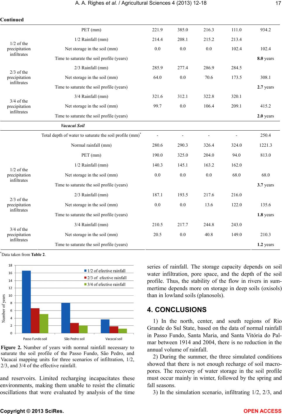
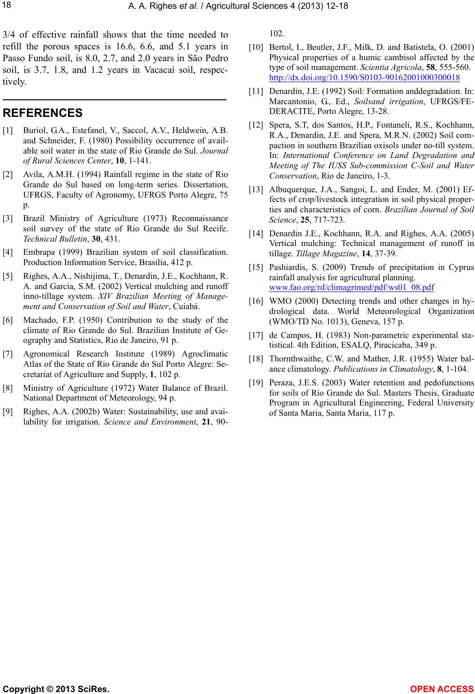
This study was conducted in three soil-mapping units
in three regions of the RS, with the following objectives:
1) determine the variation of annual and seasonal pre-
cipitation over time, 2) determine which seasons of the
year effective rainfall can refill the soil water profile, and
3) estimate the time required to fill the pore space of the
soil profile with water available from the effective rain-
fall with different scenarios of water infiltration into the
soil.
2. METHODS
The study was conducted in the north of the RSon the
Passo Fundosoil-mapping unit, classified as oxisol;in the
center of the RS on the São Pedro soil-mapping unit,
classified as red-yellow podzolic loam texture; and in the
south of the RS onthe Vacacaí soil-mapping unit, classi-
fied as planosolo hydromorphic eutrophic, used with
flood-irrigated rice [3,4].
The study of temporal rainfall was done using monthly
and annual totals data from three weather stations: Passo
Fundo (latitude 28˚15'39''S, longitude 52˚24'33''W, and
altitude 678 m), Santa Maria (latitude 29˚41'25''S, longi-
tude 53˚48'42''W, and altitude 138 m), and Santa Vitória
do Palmar (latitude 33˚31'14''S, longitude 53˚21'47''W,
and altitude 6 m), located, respectively, in the north, cen-
ter, and south of the RS. Data were obtained from the
Eighth District of Meteorology (8th DISME) of the Na-
tional Institute of Meteorology (INMET), in Porto Alegre.
The observation period of rainfall for the three sites was
1914 to 2004. From the monthly totals, annual and sea-
sonal monthly averages were obtained, taking into con-
sideration the summer months of December, January, and
February; the autumn months of March, April, and May;
the winter months of June, July, and August; and the
spring months of September, October, and November.
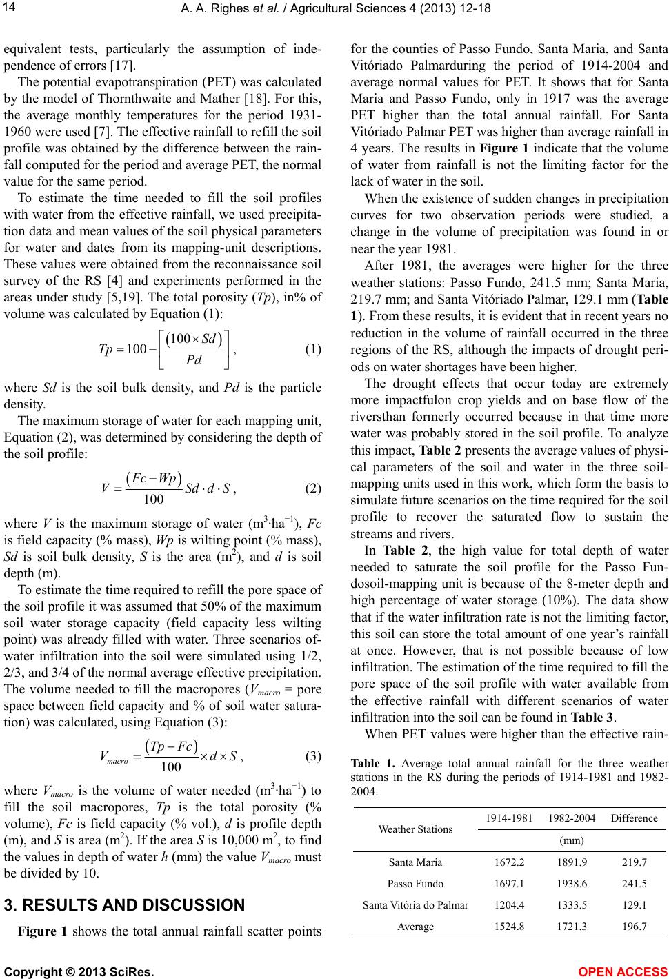
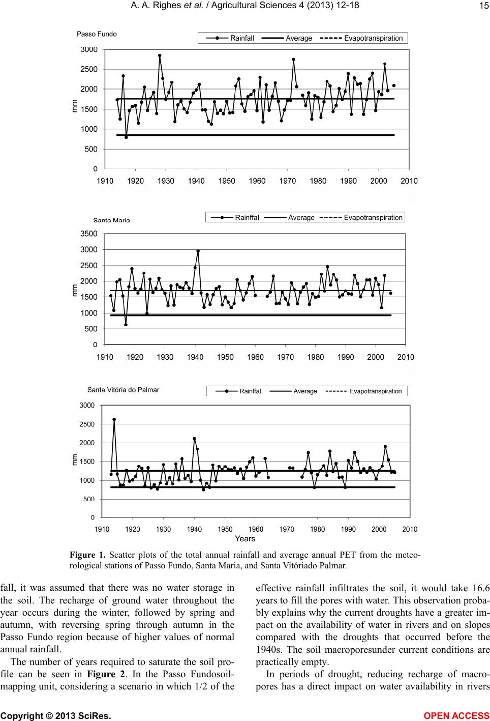
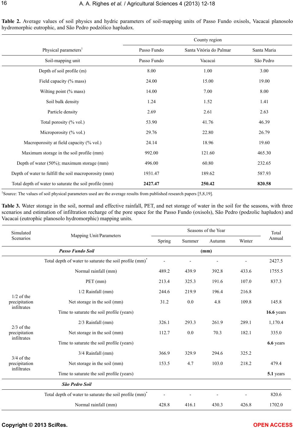
Atthe three weather stations, the rainfall was found to
be of type iso-hygro, the rain is distributed similarly over
the 12 months of the year, and the Spearman correlation
coefficient showed that the rainfall is homogeneous [15].
This coefficient shows that the rainfall is homogeneous
for the three stations, not that the system is iso-hygro.
The iso-hygro quality was checked visually. In a prelimi-
nary exploratory analysis, as suggested by the World Me-
teorological Organization [16], scatter diagrams were
plotted, relating the calendar year to the original data and
also to the centered moving average, with a period of 9
years. To verify the existence of abrupt changes in each
weather station, the historical data series was divided
into two periods and the Mann-Whitney test applied,
comparing the averages of these periods. The dividing
point was held year to year from 1918 to 1998, involving
81 test applications. The year in which the test showed a
lower minimum level of significanceMLSwas considered
the date of abrupt change. A year in which no test had p ≤
0.05 was considered a year of no abrupt changes.
The Spearman correlation coefficient and the Mann-
Whitney nonparametric test were used because rainfall
data do not meet all the requirements of parametric
Copyright © 2013 SciRes. OPEN A CCESS