International Journal of Geosciences
Vol.06 No.10(2015), Article ID:60719,13 pages
10.4236/ijg.2015.610089
Geochemical Exploration for Gold and the Association of As-Cu-Pb-Sn-Zn-Li in the Upper Proterozoic Granitoids of the Wadi Rumman Area, Southwest Jordan
Ibrahim Ahmad Ali Bany Yaseen
Institute of Earth and Environmental Sciences, Al-al-Bayt University, Al-Mafraq, Jordan
Email: ibanyyaseen@yahoo.com
Copyright © 2015 by author and Scientific Research Publishing Inc.
This work is licensed under the Creative Commons Attribution International License (CC BY).
http://creativecommons.org/licenses/by/4.0/


Received 14 September 2015; accepted 26 October 2015; published 29 October 2015
ABSTRACT
The geochemical studies were conducted in an area covering about 15 km2 of the south side of the Wadi Rumman area, SW Jordan. The study area included a part of a basement of complex exposed rocks in southwestern Jordan. The complexes comprised igneous and metamorphic suites, mostly from the late Proterozoic age. A systematic geochemical sampling was conducted using rock and heavy mineral-panned concentrate of geochemical samples. Fifty rock samples were collected from the granitic rocks, simple pegmatite dyke, quartz veins and alteration zone, which covered the area. Next, 45 heavy mineral-panned concentrate samples were collected from the alluvium in the stream sediment within the catchment area, and the dray was sieved to less than 1 mm grain size. The geochemical samples were analyzed for their trace elements and gold by using Ione Conductive Coupled Plasma Emission Spectroscopy (ICP-AES) and the Atomic Absorption Spectrometer (AAS) at Natural Resources Authority (NRA) Labs. The results of the geochemical analysis indicated the presence of gold and heavy minerals in the study area, a result considered abnormal in the rock samples. A strong positive correlation was recorded of Au with As, Cu and W (r = 0.82, 0.7 and 1.0), as with Mo (r = 0.83), Cu with Pb (r = 0.83), Sn with Mo (r = 0.73), Mo with W (r = 0.97), Zn with W (r = 0.71), and Li with Bi (r = 0.7). These correlations revealed gold associated within the hydrothermal alteration, quartz veins and pegmatite dyke. Abnormal metals such as As and Bi were good path-finders to find Au. The HM samples showed low positive linear correlations among the concentrations of Au with As, Zn and Li, and negative linear correlations of Au with Pb, Sn, Bi and W. The combination of both rock and heavy mineral concentrate samples shows four geochemical anomalous areas of gold and heavy minerals. The geochemical signatures of Au and As in the Wadi Rumman appear to be in the hydrothermal alteration, quartz veins and pegmatite dyke, respectively. Heavy mineral concentration sampling delineated the Au geochemical anomaly in area 1 specificities with the rock geochemical anomaly of area 1.
Keywords:
Geochemical Exploration, Granitoids, Rock and Heavy Mineral Samples, Wadi Rumman, Jordan

1. Introduction
Geochemical prospecting for minerals includes any method of mineral exploration based on the systematic measurement of one or more chemical properties of the naturally occurring materials. The chemical property measured is most commonly the trace content of some element or group of elements. The reason for recording these measurements is to discover abnormal chemical patterns or geochemical anomalies, related to mineralization. Among the several geochemical prospecting methods used to discover the study area, the heavy minerals and rock geochemical exploration methods were selected and used in the study area, as they were the more effective methods suitable for this type of region. Heavy mineral geochemical samples of less than 1 mm grain size were collected from the alluvium in the stream sediment, which were a useful method of verifying any decision made during the geochemical exploration for minerals, including the transport distance of the gold nuggets and ultimately regarding the origin of the element dispersion halo [1] . The fine fraction method is usually used in geochemical exploration, because of the small grain size, which makes it possible to use a small sample weight and to some extent eliminate the reduction and secondary sub sampling errors. For exploration mineralogists, the key problems arise from the low concentration thresholds of gold anomalies and the small particle size [1] . Rock geochemical samples used to collect the composite sample. The objective of this study was to undertake a geochemical exploration for minerals in the plutonic rocks, which covered the area under study, in an attempt to identify the areas of geochemical anomalies for Au, As, Cu, Pb, Sn, Mo, Bi, W, Zn and Li. It was also done to identify the possible presence of the ore minerals in the target areas by using the rock and heavy mineral geochemical exploration methods.
2. Geological Setting
The basement rocks exposed in southwestern Jordan are subdivided into two broad lithostratigraphic complexes, the Aqaba and Araba [2] - [5] . These complexes comprise the igneous and metamorphic suites, mostly of the late Proterozoic age. These complexes are separated by a regional unconformity (peneplanation), represented by the Saramuj Conglomerate Formation [6] [7] . The Aqaba complex (800 to ~570 Ma) includes the metamorphic and intrusive calc-alkaline plutonic and metamorphic rocks. The Araba complex (625 - 600 Ma), on the other hand, consists of the Safi and Feinan granitic suite, and Qirenifat and Ahaymir volcanic suites [8] . The area under study is included within the Aqaba complex and the outcropping from the late Proterozoic calc alkaline granitoids the Rumman and Yutum suite, such as Ishaar granite, Qara granite and Rashidiyya Aplite granite, respectively. The granitites are cross-cut by numerous dykes of varying composition (from acidic to basic) and thin quartz veins and an alteration zone. The lower Paleozoic sedimentary rocks for the Ram Sandstone group include Salib Arkoze Sandstone and Umm Ishrin Sandstone which are unconformable and overlaid Proterozoic igneous rocks [9] [10] . The area under study is located at 35˚15'727''E - 35˚15'730''E and 29˚30'3271''N - 29˚30'3275''N covering about 15 km2. The geological units are described as follows:
The Qara granite unit contains medium- to coarse-grained, pink- to whitish-pink to light grayish-pink syenogranite to monzogranite. The mesocratic rocks include small mafic clots at the outcrop, highly weathered and cut by dense dykes of rhyolite and quartz veins. The main mineral composition includes quartz, alkali feldspar and biotite with traces of hornblende and phaneritic in texture, particularly along the margins of the zone in contact with the Ishaar unit. Ishaar granite is medium to coarse grained, phaneritic in texture, grey to greenish- grey, which varies according to the granodiorite. Mesocratic, small circular mafic clots with biotite and hornblende are common, cut by dykes of variable compositions of rhyolite, pegmatite and quartz vines. Quartz, alkali feldspar and biotite constitute the main mineral composition. Rashidiyya Aplite Granite is distinguished by fine grain size, micro granite, pink to whitish-pink colors, leucocratic and sugary with aplitic texture. Acidic dykes and thin quartz veins cut through this unit. Quartz alkali feldspar and biotite form the main mineral composition. Salib Arkosic Sandstone Formation, Early Cambrian in age, consists predominantly of yellow, pink, and purple-brown colors, with very coarse- to medium-grained, cross-bedded arkosic and subarkosic sandstone; pebbles to cobble conglomerates are also locally present. Rounded to sub-rounded pebbles of milky-white quartz and pink feldspar are also seen. Umm Ishrin Sandstone Formation includes the middle to late Cambrian age, with brown, red-brown to yellowish-pink and grey colors, of medium to coarse-grained quartz arenite, with rounded granules and quartz pebbles. There are thin beds of fine-grained sandstone and siltstone exhibiting lineation. Secondary ferruginous and manganese ferrous show color banding and oxides with a massive-weathering face and the typical large trough cross-bedding with pebbles, occasionally overturned for sets is common. Angular clastic siltstone in locally eroded channels is evident, close to the gradational upper boundary of the formation; Figure 1 shows the geological map of the area of study.
The geologic structures of the area under study are affected by the tectonic activity that occurred during the late Proterozoic to the early Cambrian for the extension of the Arabian-Nubian shield which plunges to south Jordan [11] [12] . The early Paleozoic rocks of the Aqaba and Araba complexes of the Precambrian basement are affected by the northwest striking faults and tension joints. The NN-SSW faults, parallel to the rift, extend south into Saudi Arabia, where normal faulting and sinistral strike-slip movements can be demonstrated [13] . Major faults within the Aqaba complex are oriented to the north-northeast (0˚ - 15˚) trend, revealed by the extensive Wadi Rumman and Wadi Rum faults. The areas of study (Wadi Rumman) affected by these faults, have recorded 300 - 450 m westerly downthrows and 4 - 5 km sinistral lateral displacement [10] . The principal and subsidiary joints are shown in the various study units, in the E-W, ENE-WSW, and in the NE-SW directions for the study of the granitoid units and the NW-SE, N-S and E-W trends in the direction shown for the Salib and Umm Ishrin formations.
3. Sampling and Analytical Techniques
Two geochemical methods of investigating rocks and heavy minerals were used in the geochemical exploration of the area under study. Sample points were selected from a published 1:50,000 scale topographic and geological map.

 (a) (b)
Figure 1. (a) Simplified Geological map of Jordan show the Area study after [15] ; (b) Geological map of the area under study after [9] .
Fifty rock chip samples were collected from the outcropping of the granitic rocks, simple pegmatite, dyke, quartz veins and alteration zone, at a density of five samples per 1 km2 (Figure 2(a)). The lithology, quartz veins and alteration intensity of the rocks were studied in the field under natural light using high magnification lenses. Thin sections were then prepared and detailed mineralogical and alteration features were studied under the petrographic microscope. The samples crushed and powdered using a stainless steel Jaw Crusher and an Agate Ball Mill machine, to obtain grain size less than −63 μ. The samples were quartered in order to get a statistically representative (splitter) fraction and powdered using two geochemical techniques at the Natural Resources Authority (NRA) labs.
Forty-five heavy mineral concentrated samples were collected from the alluvium in the stream sediment within the catchment area of the study, at a density of four samples per 1 Km2 (Figure 2(b)). Then dry stainless steel sieving was performed at the sampling site to get about 4 L by volume of alluvium, of grain size less than 1mm. The samples were then placed in 8 L stainless-steel pans, and washed in sea-water close to Aqaba to eliminate material by the law of specific gravity and collect a resultant of about 200 g of heavy mineral concentrates. The concentrates were rinsed thoroughly in fresh water, placed on plates and sun dried.
Analytical Techniques
The trace elements were analyzed by decomposition using Ione Inductively Conductive Coupled Plasma Emission Spectroscopy (ICP-AES) at Natural Resources Authority Labs. A total of 1 g of the powdered (<80 mesh) sample mixed with 3 g of sodium peroxide (Na2O2) were placed in a zirconium crucible, and fused by heating it to 450˚C for 45 mints, to obtain a sinter. Subsequently, 72 ml of deionized water was added to it and stirred for a few mints; then 28 ml of diluted HCl in a ratio 1:1 was added to obtain clear solutions that were used to determine the trace element concentrations.
The Atomic Absorption Spectrometer (AAS), PerkinElmer 3030 Model was used for gold analysis in the Natural Resources Authority Labs. The analytical method consisted of dissolving the Au in the sample by heating with aqua regia solution (3 ml conc. HCl + 1 ml conc. HNO3) plus iron. The gold (Au) was then extracted with methyl isobutyl ketone (MIBK) solution by introducing the organic phase into a pyrocoated graphite furnace and then analyzed for gold using the Atomic Absorption Spectrometer [14] . The gold concentration was expressed in parts per billion (ppb). The lower detection limit of this analysis method was (10 parts per billion (ppb). Excel 2007 and Surfer 8 were used to perform statistical analyses of the data.
 (a) (b)
Figure 2. (a) Rock sample location map; (b) Heavy mineral sample location map.
The mineral composition identified by using the petrographic microscope and X-ray Diffraction (XRD) by employing a Philips diffractometer with Cu Ka radiation, at the University of Al al-Bayt.
4. Results and Discussion
4.1. Petrography and Mineralogy
The rock samples study showed leucocratic, holocrystalline and hypidiomorphic to allotriomorphic fine- to medium-sized grains, phaneritic to megaprophyritic in texture. Using the polarizer microscope and XRD, quartz, feldspar, biotite, hornblende and opaque minerals such as iron oxide and magnetite, were the main minerals identified. The secondary minerals included calcite, sericite, kaolinite and chlorite while the rare minerals found were wolframite (W), davite (B) and cassiterite (Sn). The common textures of the rock samples in the study were perthitic, poikilitic interstitial, zoning and polysynthetic twinning. The lithology and petrography of the area under study showed an alteration zone with high concentration of secondary and oxide minerals. These were indications of the mineralization ore minerals which were documented by chemical analysis for gold and the pathfinders for the geochemical association of the elements. The lithology and petrography are summarized in Table 1.
4.2. Rock Geochemistry
The earlier regional geochemical survey of the rocks of the Upper Proterozoic (Aqaba and Araba complexes) in southwest Jordan had been conducted for the regional geochemical survey project [15] . The average concentrations (ppm) of the trace elements in the Aqaba and Araba complexes, that comprise the igneous and metamorphic suites, mostly of the late Proterozoic age were reported by [15] , as 10 mg/ton for Au, 15 ppm for As, 20 ppm for Cu, 15 ppm for Pb, 7 ppm for Sn, 5 ppm for Mo, 9 ppm for Bi, 6 ppm for W, 5 ppm for Zn and 5 ppm for Li. According to [16] , the epithermal gold mineralization investigated in the Wadi Abu Khushayba within the calc-alkaline granitic rocks includes the late Proterozoic rocks within the Araba complex. The area under study includes the Aqaba complex and outcropping of the late Proterozoic calc alkaline granitoids.
The trace background values of the study area were taken as the mean and median values [17] , as shown in Table 2(a). In fact, [18] suggested that the background could be used as the median. The separation between the background and anomalous values were defined using the classical statistical treatment with the threshold calculation from the mean and median plus two standard deviations (SD) [19] . The results from the data for the area of study were treated with statistically cumulative frequency plots. The statistical calculations for the area were more or less similar reflecting the search for a similar target lithology. The statistical treatment of the rock data resulted in the adoption of two threshold values (Threshold 1 = mean + 2 SD) and (Threshold 2 = median + 2 SD) respectively, and the background values were equal to the mean value. The data below the value of the detection limits were assumed as the minimum value of the analyzed element and the statistical parameters were then computed on this assumption and the maps of geochemical anomalies, Figure 3. Thresholds 1 and 2 for Au equal 44 & 38.6, As 26.98 & 25.28, Cu 97.03 & 79.4, Pb 73.23 & 75.6, Sn 82.86 & 68.66, Mo 48.8 & 42, Bi 8.9 & 7.8, W 34.1 & 30.4, Zn 153.08 & 138.28 and Li 184.4 & 159.84, respectively (Table 2(a)).
The Pearson’s correlation coefficients from among the concentrations of Au, As, Cu, Pb, Sn, Mo, Bi, W, Zn and Li found in the study of the rock samples are presented in Table 2(b). Low positive linear correlations among the concentrations of Au, Zn, As, Sn, Cu, Pb, Sn, Mo, Li and Bi were clearly observed: Au with Zn (r = 0.06), As with Sn (r = 0.16), Cu with Sn (r = 0.1), Cu with Zn (r = 0.03), Pb with Zn (r = 0.34), Sn with Zn, Li, Bi and W (r = 0. 27, 0.2, 0.17 and 0.032, respectively), Mo with Zn (r = 0.01) Zn with Li and Bi (r = 0.4 and 0.1). Strong, positive correlation of Au with As , Cu and W (r = 0.82, 0.7 and 1.0), As with Mo (r = 0.83), Cu with Pb (r = 0.83), Sn with Mo (r = 0.73), Mo with W (r = 0.97), Zn with W (r = 0.71), Li with Bi (r = 0.7), these correlations revealed that the hydrothermal alterations affect the association of the metals in the area and some metals, such as As and Bi, are good path-finders for Au [20] . This may indicate that Au is found in association with sulfide minerals rather than quartz veins. The major correlation for the Cu, Pb, Zn, Sn, Mo and W components indicate that their association was with the sulfide veins. Negative correlations were observed for Au with Pb, Sn, Mo, Li and Bi; As with Cu, Pb, Zn and Li; Cu with Mo, Bi and W; Pb with Sn, Mo and Bi; Mo with Li; Li with W and Bi with W (Table 2(a)). These results indicate that the analysis of the metals is not linked with each other. Furthermore, these metals have different natural sources such as hydrothermal alteration, quartz veins and pegmatite dyke depending upon the area under study.

Table 1. Lithology and petrography of the rock samples of the study.
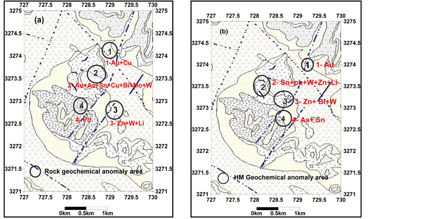
The geochemical anomaly map for the rock samples of Au, As, Cu, Pb, Sn, Mo, Bi, W, Zn and Li are shown in Figure 3. Four geochemical areas of anomalies are represented in the geochemical anomaly area map Figure 5(a). The anomalous areas are concentrated within the alteration and quartz veins. Strong geochemical anomalous areas for Au overlapping Cu, As, Sn, Bi, Mo and W are those represented by the hydrothermal alteration zone [anomaly 1 = (Au value 50 ppb overlap Cu) and anomaly 2 = Au value 50 ppb overlap As + Sn + Bi + Mo + W], anomaly 3 represented the pegmatite to rhyolite dyke [anomaly 3 = W overlap Zn + Li), and anomaly 4 showed a high degree of alteration and crashed rocks, with trace Cu and Pb minerals]. The ore in anomaly area 2 (Au, As, Sn, Cu, Bi, Mo and W) explains the presence of the ore minerals expected to occur, such as specularite, pyrrhotite, cassiterite, arsenopyrite, molybdenite, chalcopyrite, poor gold, sphalerite and wolframite and the alteration rocks were shown to have undergone albitization, sericitization and chloritization for rocks which often have a crisp wall [21] [22] , (see petrography and mineralogy section).


Figure 3. Geochemical map showing the distribution of (Au, As, Cu, Pb, Sn, Mo, Bi, W, Zn, Li) in the rock samples.
4.3. Heavy Mineral Geochemistry
The heavy mineral (HM) method has been found to be more sensitive for detection and discovery in mineral exploration. This method has been in use for the last 100 years for exploration of gold by panning. The recent, heavy mineral surveys used the concentrates from the drainage sediment samples as beneficial geochemical and mineralogical guides to mineralization [23] . The collection of the large sample > 20 L and concentration of the desired minerals into small sub-samples was effective in the process of gold exploration. The production and analysis of the heavy minerals are yet to become popular as the common exploration methods to detect the anomalous areas. These methods have been successfully applied and used in the study of the granitoid rock cover in southwest Jordan. Using the stream sediment for the study of the geochemical heavy mineral samples was found to be the best method for geochemical surveys. It includes a wide variety of environments from large gravel bars in rivers or to tiny pools of sediment, in rock narrow creeks and to dry washes in arid climates. The sample site selected for bars showed the presence of sand and gravel because the concentration of heavy minerals typically occurs in these specific areas. The best heavy mineral samples collected from the silt or clay particles from quiet water sedimentation or high-energy environments within the sediments provided the best material. The sample
(a) (b)
Table 2. (a) Statistical analysis data for the rock samples; (b) Correlation matrix of the trace elements for rock samples.
studies provided high-energy sediments in dry arid climates.
The geochemical data analysis for HM was treated to get the results of the geochemical statistics and maps of the geochemical anomalies Figure 4. The statistical treatment of the HM data resulted in the adoption of two threshold values (Threshold 1 = mean + 2 SD) and (Threshold 2 = median + 2 SD) respectively; the background values were equal to the mean value [19] . Thresholds 1 and 2 for Au = 22.52 & 21.91, As = 30.20 & 28.24, Pb = 121.84 & 122.40, Sn = 120.64 & 123.40, Bi = 47.60 & 49.80, W = 76.70 & 73.00, Zn = 333.48 & 330.48, and Li = 47.20 & 45.20, respectively (Table 3). The Pearson’s correlation coefficients for the HM data showed low positive linear correlations among the concentrations of Au with As, Zn, Li, and negative linear correlations Au for Pb, Sn, Bi and W. Moderate positive correlation of the Pb with Zn and Li (r = 0.58 and 0.56), Bi with W ( r = 0.6), W with Li (r = 51) Table 4. These correlations revealed that the hydrothermal alterations affected the study area and the associations of some metals with sulfide were weathered to the stream sediment like Pb and Zn; but Li sources, suggest the pegmatite dyke crossing the area and some metals such as Bi are good path-finders for Au [20] .
The geochemical anomaly map for the HM samples of Au, As, Pb, Sn, Bi, W, Zn and Li is shown in Figure 5. Four geochemical anomaly areas are documented in Figure 5(b). The anomalous areas were concentrated within the stream crossing the alteration zone, quartz veins and pegmatite dyke. The anomaly area 1 for Au overlaps with the Au + Cu anomaly for the rock samples; anomaly area 2 for Sn + Pb + Zn + W + Li overlaps anomaly area 2 for the rock samples. The anomalous areas 3 and 4 represented the areas in the downstream. These re-


Figure 4. Geochemical map showing the distribution of (Au, As, Pb, Sn, W, Zn, Li and Bi) for heavy mineral samples.
Table 3. Statistical analysis data for heavy mineral samples.
Table 4. Correlation Matrix for samples of heavy minerals.
 (a) (b)
Figure 5. Geochemical anomalous elements area map for (a) rock and (b) heavy mineral samples.
vealed the association of the metals in alteration with the host rocks and accumulated within the sediment deposits. According to [24] , the exploration for gold (105 ppb for HM and 200 ppb in the quartz veins) in the same granitoid unit of the the wadi Al Marsad area, have been documented as having the possible occurrence of gold in the area under study.
5. Conclusion
Detailed geochemical investigations of the rock and stream sediments for the HM samples were done during the geochemical exploration for the study area. High background values of metals at a hydrothermal alteration zone have been discovered, naturally. The discovery of the south Wadi Rumman area prospect during the following up of an already delineated anomaly has been a successful exploration using rock and <1 mm heavy mineral sediment geochemistry. Moreover, the sampling technique was proven to be a very sensitive exploration tool even in the discovery of small-scale mineralization, in areas having well-developed drainage, as in the Wadi Rumman area. Identification and sampling of the altered and mineralized rocks, which floated in the streams, were critical in categorizing the details of the geochemical results [25] . Rock sampling effectively delineated the ÓAu-over- lapping Cu, As, Sn, Bi, Mo and W geochemical anomaly. The geochemical signatures of Au and As in the Wadi Rumman appear to be hydrothermal alterations, quartz veins and pegmatite dykes, respectively. Effective Heavy Mineral sampling and delineated Au geochemical anomaly of area 1 specificities with the rock geochemical anomaly of area 1, and no negate Au were investigated in the study samples.
Acknowledgements
The author is thankful to the Natural Resources Authority for assistance in geochemical analysis and to ICP- AES and (AAS) for their contribution to the project “Detailed Geochemical Prospecting Minerals for Proterozoic granitoids, Southwest Jordan”. The author is indebted and grateful to the anonymous reviewers for their comments and assistance in improving the manuscript quality.
Cite this paper
I.A.A.Bany Yaseen, (2015) Geochemical Exploration for Gold and the Association of As-Cu-Pb-Sn-Zn-Li in the Upper Proterozoic Granitoids of the Wadi Rumman Area, Southwest Jordan. International Journal of Geosciences,06,1140-1153. doi: 10.4236/ijg.2015.610089
References
- 1. Vladimir, K., Esa, S., Pavel, S. and Erik, T. (2000) Gold Geochemistry and Mineralogy of Till Fines: A New Approach for Data Integration. Bulletin of the Geological Society of Finland, 72, Parts 1-2, 57-69.
- 2. Rashdan, M. (1988) The Regional Geology of Aqaba-Wadi Araba Area. Bull No. 7. Geology Director. Natural Resources Authority, Amman.
- 3. Jarrar, G., Wachendorf, H. and Zellmer H. (1991) The Saramuj Conglomerate: Evolution of a Pan-African Molasse Sequence from Southwest Jordan. Neues Jahrbuch fur Mineraloggie and Palaeontogie, 335-356.
- 4. McCourt, W. and Ibrahim, K. (1990) The Geology, Geochemistry and Tectonic Setting of the Granite and Associated Rocks in the Aqaba and Araba Complexes of Southwest Jordan. Bull. 10, Geology Director, Natural Resources Authority, Amman.
- 5. Ibrahim, K.M. and McCourt, W.J. (1995) Neoproterozoic Granite Magmatism and Tectonic Evolution of the Northern Arabian Shield, Evidence from Southwest Jordan, Journal African Earth Sciences, 20, 103-118. http://dx.doi.org/10.1016/0899-5362(95)00037-T
- 6. Jarrar, G., Wachendorf, H. and Zachmann, D. (1993) A Pan-African Alkaline Pluton Intruding the Sarmouj Conglomerate Southwest Jordan. Geologische Rundschau, 82, 121-135.
http://dx.doi.org/10.1007/BF00563275 - 7. Jarrar, G., Stern, R.J., Saffarini, G. and Al-Zubi, H. (2003) Late and Post Orogenic Neoproterozoic Intrusion of Jordan: Implication for Crustal Growth in the Northernmost Segment of the East African. Orogen Precambrian Research, 23, 295-319. http://dx.doi.org/10.1016/S0301-9268(03)00073-1
- 8. Rabba, I. and Ibrahim, K. (1988) Petrography of the Plutonic Rocks of the Aqaba Complex. Bull No. 9. Geology Director, Natural Resources Authority, Amman.
- 9. Abdulhamid, G. (1986) Geological Map Jabal Um Ishrin (Wadi Rum), Scale 1:50,000. Natural Resources Authority, Geological Directorate, Amman.
- 10. Abdulhamid, G. (1990) The Geology of Jabal Umm Ishrin Area (Wadi Rum), Map Sheet No. 3049II. Bulletin 14, Natural Resources Authority, Geological Directorate. Map Division, Amman.
- 11. Bender, F. (1974) Geology of the Arabian Peninsula, Jordan. US Geological Survey Professional Paper, 36, 1-560.
- 12. Barjous, M. (1987) Structural Study of the Area between Petra an Ash Shawbak. MSC. Theses, University of Jordan, Amman.
- 13. Clark, M.D. (1985) Late Proterozoic Crustal Evolution of the Midyan Region, Northwestern Saudi Arabia. Geology, 13, 611-615. 2.0.CO;2>http://dx.doi.org/10.1130/0091-7613(1985)13<611:LPCEOT>2.0.CO;2
- 14. Meier, A.L. (1980) Flameless Atomic-Absorption Determination of Gold in Geological materials. Journal of Geochemical Exploration, 13, 77-85. http://dx.doi.org/10.1016/0375-6742(80)90022-9
- 15. NRA and BRGM PROJECT Staff (1994) Geochemical and Mineral Exploration of Araba-Aqaba Complex—Final report. NRA, Amman, 209.
- 16. Al-Hwaiti, M., Zoheir, B., Lehmann, B. and Rabba, I. (2010) Epithermal Gold Mineralization at Wadi AbuKhushayba, Southwestern Jordan. Ore Geology Reviews, 38, 101-112.
http://dx.doi.org/10.1016/j.oregeorev.2010.07.002 - 17. Wang, X.Q., Xie, X.J., Cheng, Z.Z. and Liu, D.W. (1999) Delineation of Regional Geochemical Anomalies Penetrating through Thick cover in Concealed Terrains—A Case History from the Olympic Dam Deposit, Australia. Journal of Geochemical Exploration, 66, 85-97.
http://dx.doi.org/10.1016/S0375-6742(99)00036-9 - 18. Levinson, A.A. (1974) Introduction to Exploration Geochemistry. Applied Publishing Ltd., Wilmette.
- 19. Rose, A.W., Hawks, H.E. and Webb, J.H. (1979) Geochemistry in Mineral Exploration. Academic Press, New York.
- 20. Anne, T., Pertti S. and Helena H. (2015) Gold Exploration Using Heavy Minerals in Till and Weathered Bedrock in Petajaselka, Northern Finland. Geochemistry: Exploration, Environment, Analysis, 15, 205-221. http://dx.doi.org/10.1144/geochem2014-288
- 21. Anthony, M. (1993) Ore Geology and Industrial Minerals an Introduction. 3rd Edition, Blackwell Publishing, Malden, 389.
- 22. Marcondes, L.C., Romulo, S. and Newton, C. (1999) The Geochemical Association Au-As-B-Cu-Sn-W in Latosal, Colluviums, Lateritic Iron Crust and Gossan in Carajas, Brazil: Importance for Primary Ore Identification. Journal of Geochemical Exploration, 67, 33-49.
http://dx.doi.org/10.1016/S0375-6742(99)00065-5 - 23. Bill, G. and Geo, P. (2015) Discovery Mineral Exploration Consultants. info@discoveryconsultants.com
- 24. Al-Dalo Abdul, R. and Bany Yaseen, I. (2007) Geochemical Exploration for Gold and Minerals of Northern Wadi El Marsad Area, Natural Resources Authority, Geochemistry Division, Amman.
- 25. Hseyun, Y. (2007) Stream Sediment Geochemical Exploration for Gold in the Kazda? Dome in the Biga Peninsula, Western Turkey. Turkish Journal of Earth Sciences, 16, 33-55.�