 Open Journal of Forestry 2013. Vol.3, No.4, 129-137 Published Online October 2013 in SciRes (http://www.scirp.org/journal/ojf) http://dx.doi.org/10.4236/ojf.2013.34021 Copyright © 2013 SciRes. 129 Recent Trends of Fire Occurrence in Sumatra (Analysis Using MODIS Hotspot Data): A Comparison with Fire Occurrence in Kalimantan Nina Yulianti1, Hiroshi Hayasaka1, Alpon Sepriando2 1Graduate School of Engineering, Hokkaido University, Sapporo, Japan 2Meteorological, Climatology and Geophysical Agency of Central Kalimantan, Palangkaraya, Indonesia Email: Nina@eng.hokudai.ac.jp Received June 21st, 2013; revised August 6th, 2013; accepted August 21st, 2013 Copyright © 2013 Nina Yulianti et al. This is an open access article distributed under the Creative Commons Attribution License, which permits unrestricted use, distribution, and reproduction in any medium, provided the original work is properly cited. MODIS (Moderate Resolution Imaging Spectroradiometer) hotspot and precipitation data for the most recent 11-year period (2002 to 2012) were analyzed to elucidate recent trends in the seasonal and spatial fire occurrence in Sumatra and the relationship with precipitation. Using a latitude line of S 0.5˚, Sumatra was divided into two regions, N. (north) and S. (south) Sumatra. Different trends in seasonal fire occur- rence were discussed and further defined by considering two different precipitation patterns. Analysis of hotspot (fire) data was carried out using 0.5˚ × 0.5˚ grid cells to evaluate recent trends of spatial fire oc- currence. Analysis results of hotspot and precipitation data were also tallied every 10-day to find the rela- tionship between seasonal fire occurrence and the dry season. Standard deviation (SD) and variance (V) were then used to evaluate fire occurrences in Sumatra and Kalimantan objectively. The relatively mild fire occurrence tendency in Sumatra compared to Kalimantan could be the result of different stages of forest development or the high deforestation rate in Sumatra compared with Kalimantan. This paper also shows that the two different seasonal fire activities in N. and S. Sumatra were closely related to the two different dry season types: a winter and summer dry season type (WD & SD) in N. Sumatra, and a summer dry season type (SD) in S. Sumatra. Extreme fire occurrences in the Dumai region in 2005 and Palembang region in 2006 could be partially explained by a severe drought occurrence enhanced by two different kinds of El Niño events. Keywords: Drought; Dry Season; El Niño; MODIS Hotspot; Peatland Fire Introduction During 1997 and 1998, areas of forest measured approxi- mately 45,000 km2 were destroyed by extreme fires in Kali- mantan and Sumatra, releasing more than 2.6 gigatonnes of CO2 to the atmosphere (Tacconi, 2003), and causing a trans- boundary haze event in South East Asia. An estimate of the size of the area burned in East Kalimantan alone, between January and April 1998, was 52,000 km2 (Siegert et al. 2001). In addi- tion to this vast amount of damage, the fires caused serious health and economic problems within the region (Dennis, 1999). Since then, Sumatra and Kalimantan have experienced frequent fire occurrences, but as discussed in our preliminary paper, (Yulianti et al., 2012), the number has diminished. It is notable that the frequent fire occurrence in Sumatra coincides with the rapid rate of deforestation occurring over the past 10-years (2000-2012), which has been at a rate of about 23.7%/(10-yr) for all forests and 5.2%/(yr) for peat swamp forest (Miettinen et al., 2011a). Since 1990, deforestation in Sumatra has contributed to a loss of 7.45 million hectares in an area of primary forest meas- ured 75,000 km2 (Margono et al., 2012); a faster rate than in Kalimantan. In other words, the present area of forest in Suma- tra (120,000 km2) is smaller than that of Kalimantan (250,000 km2), as officially reported by the Ministry of Forestry of In- donesia (MoF, 2012). It is also evident that most fires are re- lated to agriculture activity, and this is consistent with Sumatra being home to the largest industrial plantations in Indonesia (15,280 km2 Joosten et al., 2012), as well as the most prolific cultivation of palm oil (10,467 km2, Miettinen et al., 2012). During development of the Tidal-coast Development Project, which began in the late 1960s in Sumatra (Furukawa, 2004), for instance, the swamp drainage channels caused a noticeable reduction in the dry season water table (Fearnside, 1997) and provided a low ground water level environment, which is very suitable for the occurrence of peat fires. This also occurred in the MRP area in Kalimantan (Putra & Hayasaka, 2011). Slash- ing and burning activities associated with the rapidly increasing number of plantation crops and industrial forests, have de- stroyed the peat swamp forests in both Kalimantan and Sumatra. This has caused serious environmental problems, and long- burning fires occur from January to October every year (Yuli- anti et al., 2012). For instance, vegetation fires in the southern peatland of Sumatra, often occur in relation to burning activities within the plantations during the dry season (Stolle et al., 2003). 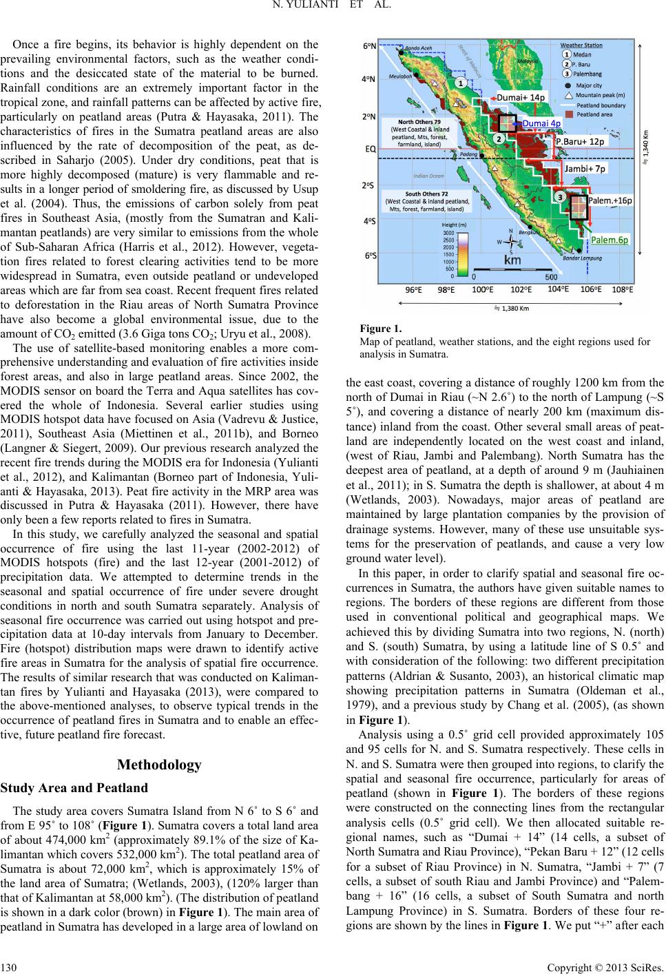 N. YULIANTI ET AL. Once a fire begins, its behavior is highly dependent on the prevailing environmental factors, such as the weather condi- tions and the desiccated state of the material to be burned. Rainfall conditions are an extremely important factor in the tropical zone, and rainfall patterns can be affected by active fire, particularly on peatland areas (Putra & Hayasaka, 2011). The characteristics of fires in the Sumatra peatland areas are also influenced by the rate of decomposition of the peat, as de- scribed in Saharjo (2005). Under dry conditions, peat that is more highly decomposed (mature) is very flammable and re- sults in a longer period of smoldering fire, as discussed by Usup et al. (2004). Thus, the emissions of carbon solely from peat fires in Southeast Asia, (mostly from the Sumatran and Kali- mantan peatlands) are very similar to emissions from the whole of Sub-Saharan Africa (Harris et al., 2012). However, vegeta- tion fires related to forest clearing activities tend to be more widespread in Sumatra, even outside peatland or undeveloped areas which are far from sea coast. Recent frequent fires related to deforestation in the Riau areas of North Sumatra Province have also become a global environmental issue, due to the amount of CO2 emitted (3.6 Giga tons CO2; Uryu et al., 2008). The use of satellite-based monitoring enables a more com- prehensive understanding and evaluation of fire activities inside forest areas, and also in large peatland areas. Since 2002, the MODIS sensor on board the Terra and Aqua satellites has cov- ered the whole of Indonesia. Several earlier studies using MODIS hotspot data have focused on Asia (Vadrevu & Justice, 2011), Southeast Asia (Miettinen et al., 2011b), and Borneo (Langner & Siegert, 2009). Our previous research analyzed the recent fire trends during the MODIS era for Indonesia (Yulianti et al., 2012), and Kalimantan (Borneo part of Indonesia, Yuli- anti & Hayasaka, 2013). Peat fire activity in the MRP area was discussed in Putra & Hayasaka (2011). However, there have only been a few reports related to fires in Sumatra. In this study, we carefully analyzed the seasonal and spatial occurrence of fire using the last 11-year (2002-2012) of MODIS hotspots (fire) and the last 12-year (2001-2012) of precipitation data. We attempted to determine trends in the seasonal and spatial occurrence of fire under severe drought conditions in north and south Sumatra separately. Analysis of seasonal fire occurrence was carried out using hotspot and pre- cipitation data at 10-day intervals from January to December. Fire (hotspot) distribution maps were drawn to identify active fire areas in Sumatra for the analysis of spatial fire occurrence. The results of similar research that was conducted on Kaliman- tan fires by Yulianti and Hayasaka (2013), were compared to the above-mentioned analyses, to observe typical trends in the occurrence of peatland fires in Sumatra and to enable an effec- tive, future peatland fire forecast. Methodology Study Area and Pe atland The study area covers Sumatra Island from N 6˚ to S 6˚ and from E 95˚ to 108˚ (Figure 1). Sumatra covers a total land area of about 474,000 km2 (approximately 89.1% of the size of Ka- limantan which covers 532,000 km2). The total peatland area of Sumatra is about 72,000 km2, which is approximately 15% of the land area of Sumatra; (Wetlands, 2003), (120% larger than that of Kalimantan at 58,000 km2). (The distribution of peatland is shown in a dark color (brown) in Figure 1). The main area of peatland in Sumatra has developed in a large area of lowland on Figure 1. Map of peatland, weather stations, and the eight regions used for analysis in Sumatra. the east coast, covering a distance of roughly 1200 km from the north of Dumai in Riau (~N 2.6˚) to the north of Lampung (~S 5˚), and covering a distance of nearly 200 km (maximum dis- tance) inland from the coast. Other several small areas of peat- land are independently located on the west coast and inland, (west of Riau, Jambi and Palembang). North Sumatra has the deepest area of peatland, at a depth of around 9 m (Jauhiainen et al., 2011); in S. Sumatra the depth is shallower, at about 4 m (Wetlands, 2003). Nowadays, major areas of peatland are maintained by large plantation companies by the provision of drainage systems. However, many of these use unsuitable sys- tems for the preservation of peatlands, and cause a very low ground water level). In this paper, in order to clarify spatial and seasonal fire oc- currences in Sumatra, the authors have given suitable names to regions. The borders of these regions are different from those used in conventional political and geographical maps. We achieved this by dividing Sumatra into two regions, N. (north) and S. (south) Sumatra, by using a latitude line of S 0.5˚ and with consideration of the following: two different precipitation patterns (Aldrian & Susanto, 2003), an historical climatic map showing precipitation patterns in Sumatra (Oldeman et al., 1979), and a previous study by Chang et al. (2005), (as shown in Figure 1). Analysis using a 0.5˚ grid cell provided approximately 105 and 95 cells for N. and S. Sumatra respectively. These cells in N. and S. Sumatra were then grouped into regions, to clarify the spatial and seasonal fire occurrence, particularly for areas of peatland (shown in Figure 1). The borders of these regions were constructed on the connecting lines from the rectangular analysis cells (0.5˚ grid cell). We then allocated suitable re- gional names, such as “Dumai + 14” (14 cells, a subset of North Sumatra and Riau Province), “Pekan Baru + 12” (12 cells for a subset of Riau Province) in N. Sumatra, “Jambi + 7” (7 cells, a subset of south Riau and Jambi Province) and “Palem- bang + 16” (16 cells, a subset of South Sumatra and north Lampung Province) in S. Sumatra. Borders of these four re- gions are shown by the lines in Figure 1. We put “+” after each Copyright © 2013 SciRes. 130  N. YULIANTI ET AL. region to show the expanded region of each local area name (such as “Dumai+”), so as to avoid confusion with the conven- tional administrative name. The number provided at the end of the names is used to describe the number of cells that the region occupies. The other two regions, and the remaining cells from the above four regions, were simply named N. Others (79 cells), and S. Others (72 cells). Finally, two special areas, Dumai 4 in N. Sumatra and Palembang 6 in S. Sumatra, were introduced to highlight the extreme fire activities in these areas in 2005 and 2006. MODIS Hotspot Data and Grid Analysis Daily MODIS hotspot data (Collection 5.1 active fire product) from the most recent 11-year period (2002 to 2012) were auto- matically extracted from the FIRMS website (Fire Information for Resources Management System, http://earthdata.nasa.gov/ data/near-real-time-data/data/firms) and were then analyzed in this paper. Approximately 250,000 hotspots were recovered from the 11-year data for Sumatra, (which includes Insular Malaysia). In this paper, 0.5˚ grids were used to clarify the spatial trend of fire occurrence. Hotspots were tallied depending on their longitude and latitude. For a hotspot density, units of “hot- spots/cell,” and “hotspots/km2,” were used. The approximate area of these grid cells at the equator is 3070 km2, and this was used for the conversion to hotspot density, “hotspots/km2”. Weather and Precipitation Data To determine the relationship between fire activity on peat- land and weather patterns, we attempted to obtain weather data from many places in Sumatra, but were only able to purchase daily precipitation data from six stations. In this paper, we ana- lyzed precipitation data for the most recent 12-year period (2001 to 2012) measured at three airports (see Figure 1) in Medan (Polania, N 3.66˚, E 98.60˚, North Sumatra), Pekan Baru (Sultan Syarif Kasim II, N 0.47˚, E 101.45˚, Riau), and Palembang (Sultan Mahmud Badaruddin II, S 2.90˚, E 104.70˚ South Sumatra). All data belongs to the Indonesia Meteoro- logical, Climatology and Geophysical Agency (BMKG). Precipitation data measured at three weather stations in Su- matra were tallied every 10-day to define the dry season period and to explain the different trends in fire occurrence in N. and S. Sumatra. Data processing from every 10-days was applied in- stead of using other data smoothing periods of a 10-day (week) and 30-day (month), because the smoothing of data over a pe- riod of 10-day is less difficult than over other time periods. In addition, the 10-day period will enable us to label seasons by using expressions such as, “early June,” instead of “DN = 152 to 161”. Results and Discussions Dry Season Type, Period, and Lowest Daily Mean Precipitation Precipitation patterns for three weather stations (Medan, Pekan Baru (known as P. Baru), and Palembang) were calcu- lated using the recent 12-year interval from 2001 to 2012 (see Figures 2(a)-(c)). In total, 35 mean daily precipitation values for every 10-day interval, were calculated for each station, and are shown by the solid lines in the graphs in Figure 2. Each daily mean precipitation value was placed on its representative Figure 2. Dry season period in: (a) Medan; (b) Pekan Baru; and (c) Palembang derived from 12-year (2001-2012) data. point from DN = 5 to DN = 355 within the 10-day interval. In addition, simple smoothed curves (dotted lines) have been added to the graph, representing the daily mean precipitation. With the help of these two lines, we were able to ascertain the dry season period and the low precipitation values during each dry season, for each station. The definition of a dry season period for each area in this paper, follows previous analysis of Kalimantan by Yulianti & Hayasaka, (2013), and the daily mean precipitation of 5 mm/day was used as a threshold value for the dry season. By using the line for daily mean precipitation in our graph in Fig- ure 2, we can see that threshold value is apparent in Medan (N 3.66˚) in the Northern Hemisphere, revealing an approximately two month winter dry season in January and February (WD(2)) and a summer dry season (SD(2)) in June and July. In Palembang (S 2.90˚) in the Southern Hemisphere, there was a relatively long dry season, about 4-month SD(4) from June to September, and in P. Baru (N 0.47˚) near the Equator, (located between Medan and Palembang, see Figure 1), there was an intermedi- ate dry season, or a one-month quasi-winter dry season with rain (daily mean precipitation in February higher than 5.5 mm/day), and a dry season of about 2-months SD(2) in June and August. The lowest values of daily mean precipitation during the Copyright © 2013 SciRes. 131  N. YULIANTI ET AL. above-mentioned dry seasons were an indication of fire activi- ties near each weather station. In Medan, the lowest values of daily mean precipitation in WD(2) and SD(2) found in Figure 2(a) were about 2.1 mm/day in February and 4.3 mm/day in July respectively. In Palembang, the lowest value in Figure 2(c) was 1.7 mm/day in SD(4) in August. In P. Baru, the lowest value was 3.4 mm/day, from only one period in each of June and August, as shown in Figure 2(b). Moreover, the annual mean precipita- tion of P. Baru (about 3200 mm) was higher than the amounts of about 2500 and 2600 mm from the other two weather sta- tions. Reasons for this were that we could estimate that the heavy precipitation in P. Baru would mainly be due to the effect of the mountain behind the area (see Figure 1). Fire Prone Areas and Peatland Fire prone areas (>100 hotspots/(yr. cell) in the most recent 11-year period (2002 to 2012) are highlighted using different colors in Figure 3. Most of these areas are located on the east- ern side of Sumatra, but some are in the northern part. There were 12 cells showing a very high hotspot density (>400 hot- spots/(yr. cell) = 0.129 hotspots/(yr. km2)). These cells were named H1, H2, …, H12, in descending order of hotspot density. The 7 highest hotspot density cells (H1~4, H8, H11 and H12), located in the Dumai region or Dumai + 14p (Dumai4p: H1, H3, H4, and H12), cover most of the northeast coast peatland in N. Sumatra (Riau Province). According to the peatland map (Wet- lands, 2003), the Dumai region contains a peat layer that is relatively deeper (~8 mm) than other places in S. Sumatra and Kalimantan (except the MRP area). It is of note that Dumai + 14p belongs to a different climate zone than most of S. Sumatra and Kalimantan (see Figures 2(a) and 3). The seventh highest cell, H7, is located on the eastern side in Pekan Baru (capital of Riau Province) near the Equator and on the coast. The other highest cells, H5, H6, H9, and H10, are located in the region of S. Sumatra. H5 and H6 are located on the eastern side at Palembang (capital of the South Sumatran Province), and two cells in Palembang 6p. H9 in the south in Figure 3. Map of the 12-highest hotspot cells, fire prone cells, and peatland in Sumatra. Pekan Baru, and H10 in southeast Jambi are two cells included in Jambi + 7p (see Figure 3). From the distribution of these highest hotspot cells, it is evi- dent that the most recent fires in Sumatra have occurred mainly on the coastal peatland. Many of the fires on peatland can be explained by the history of development as in the MRP area of Kalimantan (Furukawa, 2004). Areas in the MRP with dense hotspots were related to high human activity such as deforesta- tion, slash and burn clearing, and the maintenance of planta- tions (Yulianti et al., 2012). Recent Fire Occurrence Trends in Sumatra Annual and Average Seasonal Fire Occurrence in N. Sumatra The stacked bar graph in Figure 4 shows the number of fires that have occurred in three regions in N. Sumatra (from bottom to top: Dumai + 14, P. Baru + 12p, and North Others 79). The annual mean numbers of fires in these three regions and those in S. Sumatra, (and the annual fire in Kalimantan), are shown in the two bars on the far right in Figure 4. The unit of the Y-axis is the number of hotspots in each region. The annual mean number of hotspots in N. Sumatra over the past 10-years was about 8600, and 60% of these fires occurred in peatland areas (Dumai + 14p and P. Baru + 12p). A com- parison of the two bars in Figure 4, shows that the number of fires in 2005, (about 27,000 hotspots/yr.), is larger than the average number in Kalimantan (23,000 hotspots/yr.). About 80% of the extreme fires in 2005 occurred mainly in peatland in the Dumai and P. Baru regions; areas responsible for approxi- mately 16,000 and 5400 fires (60.3% and 20.4%) respectively. Fire occurrences in both peatland areas were 4.2 times larger than in the North Others 79, which is predominantly non-peatland. The occurrence of fires in most years (6 out of the 10 years) in N. Sumatra was in the range of +1σ to −1σ. The variance of fire occurrence (V) of about (3900)2 was smaller than that of about (16,000)2 in Kalimantan. This relatively stable fire oc- currence in N. Sumatra may suggest that the occurrence of so- called routine fires on plantations and developed land are not so strongly related to the weather conditions, and the yearly fire Figure 4. Recent trends in annual fire occurrence in N. Sumatra. Copyright © 2013 SciRes. 132  N. YULIANTI ET AL. occurrences could be related to agriculture activities such as agricultural residue burning. Small-sized fire occurrence could, therefore, imply that large land clearing or deforestation activi- ties are no longer taking place in N. Sumatra. The extreme fire occurrences in Dumai + 14p in 2005 was an exceptional case, and the main cause of these severe fires was due to the expansion of fires lit for land clearing and agricul- tural activities. On inspection of weather data measured at Medan, (located about 400 km northeast of Dumai), these fires may also have occurred during severe drought conditions. In Medan, the drought lasted for about two months, from mid-January to mid-March in 2005, and overlapped with the dry season in N. Sumatra. In this paper, to clarify the average seasonal fire occurrence tendency in N. Sumatra, the average number of hotspots every 10-days (1/3-month) were calculated. In doing so, one active fire area named “Dumai 4p” was extracted from a part of Du- mai + 14p, to illustrate the seasonal fire occurrence clearly. From Figure 5, it can be seen that the seasonal fire occur- rence trend in N. Sumatra displays two major fire seasons: one fire peak in February and one in March, and another from May to August. Such seasonal fire peaks can be partially explained by the two precipitation patterns and the dry season periods for Medan (N 3.5˚) and P. Baru (N 0.5˚) in Figure 2. We have observed that, firstly, the winter fire peak in February (in Fig- ure 5) is mainly due to fires occurring in Dumai 4p (N 1.8˚) and P. Baru + 12p. These fires correspond to the winter dry seasons WD found in Figures 2(a) and (b). The highest fire peak for Dumai 4p (mid-February) corresponds to the lowest daily mean precipitation (about 2 mm/day) in Figure 2(a). Secondly, the early summer peak in June in Figure 5 is mainly due to fires occurring in North Others 79 and Dumai + 14p. These fires can be mainly explained by the summer dry season in P. Baru in Figure 2(b), because the low latitude 32 cells (<N 2.5) in North Others 79 are responsible for about 80% of the fires, and these cells have a similar rainfall pattern to P. Baru. Thus, most fires in N. Sumatra tend to occur under a rainfall condition of about 3.5 mm/day in mid-June, as seen in Figure 2(b). Thirdly, the highest fire peak in the whole of N. Sumatra occurs in early August. This peak in August is mainly due to the increased number of fires in P. Baru under the lowest daily rainfall of about 3.5 mm/day. Such a tendency may, therefore, imply the occurrence of peat fires in P. Baru+. 0 20 40 60 80 100 120 0 60 120 180 240 300 360 Average number o hotspots (hotspots/day) Day Number North Others ( 79 cells) P.Baru+ 12p J F M A M J J A S O N D Average fire occurrence in N. Sumatra 10‐yr data: 2002‐2012 (except 2005) :Total Number in North : Dumai+ 14p : Dumai+ 4p Areas mostly on peatland Figure 5. Recent trends of average seasonal fire occurrence in N. Sumatra. Annual and Average Seasonal Fire Occurrence in S. Sumatra The annual mean number of fires in S. Sumatra is shown in Figure 6 (using a similar graph format to Figure 4). The stacked bar graph in Figure 6 shows the number of fires in three regions in S. Sumatra, from bottom to top: Palembang + (16p), Jambi + (7p), and South Others 72. The annual mean number of fires in the three regions (excluding 2006), and the annual number of fires in Kalimantan, are shown by the two bars on the far right in Figure 6. The annual mean number of hotspots in S. Sumatra during the last 10-years was about 8900, and, approximately 47% of the fires occurred in peatland areas (Palembang+ and Jambi+). Fire data from 2006 were excluded from the statistics calcula- tion, due to severe fire occurrence (+5.3σ, +2.6σ if the data from 2006 are included) under the drought enhanced by El Niño in 2006. A comparison of the two bars in Figure 6, shows that the number of fires in 2006, (about 29,000 hotspots/yr.), was larger than that of the average number in Kalimantan (23,000 hotspots/yr.). About 57% of these extreme fires in 2006 occurred mainly in peatland areas in the Palembang+ and Jambi+ regions, which are responsible for around 13,300 and 3300 fires (45.5% and 11.4%), respectively. The occurrence of fires in both these peatland areas was 1.3 times larger than that in South Others (mostly non-peatland). The fire occurrence in the majority of years in S. Sumatra, (6 out of the 10 years), was within the range of +1σ to −1σ and the variance of fire occurrence (V) of an area of around (7200)2 was smaller than that of an area of about (16,000)2 in Kaliman- tan, but larger than that of an area of about (5900)2 in N. Suma- tra. The relatively stable fire occurrence in S. Sumatra may also suggest that continual and small-size fire occurrences are not strongly related to weather conditions, as in N. Sumatra. It is evident that the occurrence of small fires in heavy rain condi- tions during 2010 could have made the variance of fire occur- rence in S. Sumatra larger than that in N. Sumatra. The extreme fire occurrence in Palembang+ in 2006 was an exceptional case and the main cause of these severe fires was due to an expansion of fires for land clearing and agricultural Figure 6. Recent trends in annual fire occurrence in S. Sumatra. Copyright © 2013 SciRes. 133  N. YULIANTI ET AL. Copyright © 2013 SciRes. 134 Dumai, and two cells of H5 and H6 are near Palembang. A comparison of the seven highest cells from the top 12 highest hotspot density cells in Kalimantan (Yulianti & Hayasaka, 2013) are listed in Table 1. activities, and which occurred under severe drought conditions lasting three months from early August to late October in 2006, and which overlapped with the dry season in S. Sumatra. Figure 7 is similar to that of Figure 5 for N. Sumatra, and was used to clarify the average seasonal fire occurrence ten- dency in S. Sumatra. By using this graph, one fire active area named “Palembang 6p,” was defined and extracted from one part of Palembang + 16p, to clearly illustrate the seasonal fire occurrence. From Table 1, the fires in H1 near Dumai could be referred to as “extreme” fires, because the average and the maximum number of hotspots in H1 were 941 and 4494, respectively. The average number in H1 was almost the same as the value of 971 in the H1k cell in Kalimantan. However, the greatest value in H1 (4494) was the highest overall. SD values of 2.77 - 2.94 for the four highest cells in Sumatra were higher than those values (1.45 - 2.4) in Kalimantan (seen in Table 1). These differences could imply that the extreme fires in Sumatra with higher SDs were incidental fires. In contrast, the extreme fires in Kaliman- tan with lower SDs were routine fires lit for the purpose of development. The seasonal occurrence of these extreme fires in Sumatra is discussed in the sections below. From Figure 7, the trends of seasonal fire occurrence in S. Sumatra show one fire season from May to late October, with a few peaks in September. This one-fire-season pattern in S. Su- matra almost corresponds to the one-summer-dry-season pat- tern in Figure 2(c). The difference in the fire peak in Septem- ber of about one month in Figure 7 and the low of precipitation in August in Figure 2(c) can be estimated using the author’s previous research related to Kalimantan, where we found there was a time lag of approximately one month between precipita- tion and a rising ground water level (Putra & Hayasaka, 2011). This result was obtained from measurement results in peatland in Block C, the MRP, in Central Kalimantan (Takahashi et al., 2007). The Extreme Seasonal Fire Occurrence and Drought in N. Sumatra (2005) In Figure 8, seasonal fire occurrence and drought in N. Su- 0 20 40 60 80 100 120 0 60 120 180 240 300 360 Average number o hotspo ts (hotspots/da y) Day Numbe : Total Number in South South Others ( 72 cells) Jambi+ 7p : Palembang+ 16p J F M A M J J A S O N D Average fire occurrence in S. Sumatra 10‐yr data: 2002‐2012 (except 2006) :Palembang 6p Areas mostly on peatla nd From Figure 7 the highest peak can be seen in late Septem- ber for all three regions in S. Sumatra. Palembang 6p had the same values as the MRP area in Central Kalimantan, (Yulianti & Hayasaka, 2013). This could suggest that peat fires in S. Sumatra and south Kalimantan occur under a similar weather condition created by the southern monsoon during the summer months (between May and October). Recent Extreme Fire Occurrences in Sumatra Highest Hotspot Cell in Sumatra Extreme fire occurrences were observed in both N. and S. Sumatra in 2005 and 2006 respectively. The cells with the top 12 highest hotspot densities (>400 hotspots/yr.) in Figure 3 were mainly due to the occurrence of these extreme fires. The top four highest hotspot cells from H1 to H4 are located near Figure 7. Recent trends in average seasonal fire occurrence in S. Sumatra. Table 1. Comparison of the highest hotspot cells in Sumatra and Kalimantan. Rank Ave.* Max. SD (σ) for Max.Year for Max. Region H1 941 4494 2.94 2005 Dumai 4p (east) H2 686 2385 2.77 2005 Dumai (northwest) H3 624 2231 2.85 2005 Dumai4p H4 483 772 1.35 2006 Dumai4p (south) Sumatra H5 477 2966 2.95 2006 Palembang (east) H1k 971 2417 1.76 2006 MRP (C south) H2k 804 2289 1.80 2009 MRP (C north) H3k 678 1846 1.65 2002 MRP (C middle) H4k 629 629 1.45 2006 MRP (B&D) H5k 561 1443 1.51 2002 MRP (A) Kalimantan H7k 506 2298 2.40 2006 Sampit * Ave.: 11-year (2002-2012) for Sumatra, 10-year (2002-2011) for Kalimantan.  N. YULIANTI ET AL. Figure 8. Fire occurrence and accumulated precipitation in 2005. matra are found in the various curves of hotspots and precipita- tion. In the figure, N. Sumatra, fire occurrence in three regions, Dumai + 14p, P. Baru + 12p, and north others (79), are ar- ranged from bottom to top using a variety of lines. The number of hotspots in Dumai 4p is shown independently by a dotted line. The difference between Dumai + 14p and Dumai 4p shows only the fire occurrence in the 10 grid cells in Dumai + 14p, and not that in Dumai 4p or “Dumai + 10p”. Average seasonal fire occurrence over 10-years is also shown with a dotted line to highlight the severe fire occurrence in 2005. Two accumulated curves for precipitation using two solid lines of different colors, and using daily data for P. Baru and Medan, are also included so as to evaluate the severity of the drought period. From Figure 8, it is evident that the extreme fires of 2005 in N. Sumatra occurred in different regions and in different sea- sons. The most distinctive feature is that the 2005 extreme fires occurred during the dry seasons. The first extreme fires in Du- mai 4p (a part of Dumai + 14p) and P. Baru + 12p occurred during a drought in the winter dry season WD or between mid-January and mid-March. The value of more than 100 hot- spots/day was considerably higher than that of 50 hotspots/day (the 10-year average value for the whole of N. Sumatra). The following extreme fires occurred in late June in Dumai + 14p (mostly in Dumai north in Table 1). The third extreme fire peak was mostly due to fires in Dumai north and North Others (79), and occurred during early and mid-August. The extreme fires could therefore be explained by the drought conditions (using the accumulated precipitation curves in Figure 8) or by the flat part of the lines for both Medan (~2 mm/day) and Pekan Baru (~1 mm/day). The drought conditions in 2005 are likely to have been caused by the active winter boreal monsoon occurring under El Niño Modoki or quasi-El Niño conditions (Ashok et al., 2007). This abrupt, wide area drought affected the north of Southeast Asia, and caused a ris- ing by about +0.5 of the average EMI (El Niño Modoki Index) values between late 2004 and early 2005, as recorded by JAMSTEC (2013). Fires in the Dumai region, (except in Dumai4), showed an- other two peaks in late June and in early and mid August. These fires can be explained by the short, a devastating summer drought (SD) in Medan occurring in June and August, giving the lowest precipitation rate over the past 12-years. Corre- spondingly, fires in North Others (mostly areas of non-peatland) became very active in late June and early August (see Figure 8) under drought during SD. The Extreme Seasonal Fire Occurrence and Drought in S. Sumatra (2006) In Figure 9, the seasonal fire occurrence and drought in S. Sumatra are found using the various curves for hotspots and precipitation. In S. Sumatra, fire occurrence in three regions, Palembang + 16p, Jambi + 7p, and south others (72), are dis- played from bottom to top using a variety of lines (in Figure 9). The number of hotspots in Palembang 6p is independently shown by a dotted line. The difference between Palembang + 16p and Palembang 6p shows only the fire occurrence within the 10 grid cells in Palembang + 16p, and not that in Palembang 6p or “Palembang + 10p”. In Figure 9, the average seasonal fire occurrence over 10-years is also shown with a dotted line to illustrate the severe fire occurrence in 2006. An accumulated curve for precipitation using the daily data for Palembang was also added to evaluate the severity of the drought period (using solid lines). From Figure 9, we can see that the 2006 extreme fires in S. Sumatra occurred in different regions and in different seasons. Of particular note, however, is that the 2006 extreme fires in S. Sumatra also occurred during the dry season. The extreme fires in Palembang 6p (a part of Palembang + 16p) and Jambi + 7p occurred either during a drought in summer dry season SD or from mid September to mid October. Their numbers (more than 200 hotspots/day) are considerably higher than that of the 100 hotspots/day of the 10-year average values for the whole of S. Sumatra. A catastrophic fire (about 700 hotspots/day), can be ascertained by one sharp peak in early October (twice as large as in Sampit). The worst fires in the Palembang and Jambi re- gion coincided with the fire peak in the MRP area. About 60% of these fires in early October occurred in Palembang 6p (mostly in eastern Palembang in Table 1). Fire occurrences on non-peatland (or in South Others) were in early July and Au- gust, and we are thus able to refer to these fires as “warning fires” for the areas of peatland in S. Sumatra. The extreme fires occurred in Palembang, under a devastat- ing long-term drought involving a period of no rain lasting about 3-months. About 3-month prior to this drought, a pre- drought with very low rainfall (3.6 mm/day or the same rate as the annual rate in a dry season) was observed (see Figure 9). These conditions are likely to be related to the El Niño event with ONI (Ocean Niño index) values in NDJ of about +1, as discussed in relation to Kalimantan (Yulianti & Hayasaka, 2013). Figure 9. Fire occurrence and accumulated precipitation in S. Sumatra (2006). Copyright © 2013 SciRes. 135  N. YULIANTI ET AL. Conclusion Analysis results using MODIS hotspot data of the most re- cent 11-year period, clearly show trends of seasonal and spatial fire occurrence in Sumatra. The recent trends in fire occurrence are: 1. Two extreme fires occurred both in N. and S. Sumatra in 2005 and 2006 respectively under enhanced drought or rainless conditions related to two different types of El Niño events. 2. The highest hotspot cell found near east of Dumai in N. Sumatra contained an annual maximum number of hotspots of 4494 in 2005. The 11-year average number is 941/yr., and this average number is slightly smaller than the 971 hotspots observed in one of cells in the MRP region (Block C south) in Kalimantan (where a maximum number of 2417 was observed in 2006). However, the annual maximum number of 4494 within the Dumai cell is the highest re- corded. 3. The fifth highest hotspot cell found near eastern Palembang in S. Sumatra had a maximum number of 2966 hotspots in 2006, when the average number was 477/yr. This maximum number was also higher than that of 2417 in the cell in the MRP referred to above. 4. Extreme fire occurrences in N. Sumatra in 2005 and in S. Sumatra in 2006 could be partially explained by an en- hanced drought occurrence due to El Niño events. But their relatively high standard deviation (σ) values of 2.7σ in N. Sumatra, and 2.6σ in S. Sumatra (higher than 1.8σ in Kali- mantan in 2006 which was the worst recent fire year for Kalimantan), suggest that both extreme fire occurrences could be classified as accidental fires. The origin of extreme fires could be from intentional fires related to practices such as land clearing and plantation development. 5. The recent fire occurrence in Sumatra was not as intense as in Kalimantan (the annual mean number of fires was about 18,000 in the whole of Sumatra and smaller than that of 23,000 in Kalimantan). Nevertheless, the peatland area in Sumatra (about 70,000 km2) is larger than that of Kaliman- tan (about 60,000 km2). 6. With the exception of data from the extreme fire years, most of the annual fire occurrences in the recent 10-years lay between +1σ and −1σ, except for 2010 in S. Sumatra. 7. The results of spatial analysis using 0.5˚ × 0.5˚ cells for N. Sumatra, clearly show one extreme fire occurrence cell (centered at N 1.75˚ and E 101.75˚) in the southeast of Du- mai (one of the cells in Dumai + 4). Within this cell, the 11-year average number of fires was 944 hotspots/year. This result was much higher than the result of the second highest cell, at 686 hotspots/year (centered at N 2.25˚ and E 100.25˚) in the northeast of Dumai (one of the cells in Du- mai + 14). 8. In 2005, (an extreme fire year in N. Sumatra), a few clusters of hotspots were found in the southeast of Dumai (centered at around N 1.55˚ and E 101.7˚, 30 km and 115 deg. from Dumai, N 1.7˚ and E 101.5˚). From these hotspot clusters, the burnt area in the southeast of Dumai was roughly esti- mated. During January to March (DN = 1 - 90) in 2005, the burnt area of these few clusters was estimated to be more than 700 km2. 9. In late June 2005 (DN = 170 - 180) and in August 2005 (DN = 210 - 230), fires in the northwest of Dumai (centered at around N 2.0˚ and E 100.4˚, 120 km and 290 deg. from Dumai) also became active. The burnt area of these few clusters was estimated to be about 400 km2. 10. In 2006, (an extreme fire year for S. Sumatra), a few clus- ters of hotspots were also found in eastern Palembang (cen- tered at around S 2.85˚ and E 105.43˚, 76 km and 78 deg from Palembang, S 3˚ and E 104.8˚). The total burned area of these hotspots clusters was estimated to be about 500 km2. 11. The above-mentioned recent fire occurrences in Sumatra were partially explained by using various precipitation pat- terns and dry season periods for both N. and S. Sumatra. Acknowledgements This research was partially supported by the JST-JICA Sci- ence and Technology Research Partnership for Sustainable De- velopment (SATREPS) project on “Wild Fire and Carbon Man- agement in Peat-Forests in Indonesia.” REFERENCES Aldrian, E., & Susanto, R. D. (2003). Identification of three dominant rainfall regions within Indonesia and their relationship to sea surface temperature. International Journal Clim a to log y, 23, 1435-1452. http://dx.doi.org/10.1002/joc.950 Ashok, K., Behera, S. K., Rao, S. A., Weng, H., & Yamagata, T. (2007). El Niño Modoki and its possible teleconnection. Journal of Geo- physical Research, 112, C11007. http://dx.doi.org/10.1029/2006JC003798 Badan Pusat Statistik (2010). Trends of the selected socio-economic indicators of Indonesia. Jakarta: BPS-Statistic Indonesia. Chang, P., Wang, Z., McBride, J., & Liu, C. H. (2005).Annual cycle of Southeast Asia-Maritime Continent rainfall and the asymmetric mon- soon transition. Journal Climate, 18, 287-301. http://dx.doi.org/10.1175/JCLI-3257.1 Dennis, R. (1999). A review of fire projects in Indonesia (1982-1998). Jakarta, Indonesia: Center for International Forestry Research (CI- FOR). Fearside, P. M. (1997). Transmigration in Indonesia: Lessons from its environmental and social impacts. Environmental Management, 21, 553-570. http://dx.doi.org/10.1007/s002679900049 Furukawa, H. (2004). The ecological destruction of coastal peat wet- lands in Insular Southeast Asia. In H. Furukawa, M. Nishibuchi, Y. Kono, & Kaida, Y. (Eds.), Ecology destruction, health, and devel- opment: Advancing Asian paradigms (pp. 31-72). Nagoya: Kyoto University Press. Harris, N. L., Brown, S., Hagen, S. C., Saatchi, S. S., Petrova, S., Salas, W., Hansen, M. C., Potapov, P. V., & Lotsch, A. (2012). Baseline map of carbon emissions from deforestation in tropical regions. Sci- ence, 336, 1573-1576. http://dx.doi.org/10.1126/science.1217962 Indonesia Ministry of Forestry (2012). Forest statistics in 2011. Jakarta: Directorate General of Forestry Plantology. Japan Agency for Marine-Earth Science and Technology (2013). MODOKI ENSO: A new phenomenon is found in the Tropical Pa- cific. http://www.jamstec.go.jp/frcgc/research/d1/iod/modoki_home.html.en Jauhiainen, J., Hooijer, A., & Page, S. E. (2012). Carbon dioxide emis- sions from an Acacia plantation on peatland in Sumatra, Indonesia. Biogeosciences, 9, 617-630. http://dx.doi.org/10.5194/bg-9-617-2012 Joosten, H., Tapio-Biström, M., & Tol, S. (2012). Peatlands—Guid- ance for climate change mitigation through conservation, rehabilita- tion and sustainable use. Rome: The Food and Agriculture Organiza- tion of the United Nations and Wetlands International. Langner, A., & Siegert, F. (2009). Spatiotemporal fire occurrence in Borneo over a period of 10 Years. Global Change Biology, 15, 48- 62. http://dx.doi.org/10.1111/j.1365-2486.2008.01828.x Margono, B. A., Turubanova, S., Zhuravleva, I., Potapov, P., Tyukav- Copyright © 2013 SciRes. 136  N. YULIANTI ET AL. Copyright © 2013 SciRes. 137 ina, A., Baccini, A., Goetz, S., & Hansen, M. C. (2012). Mapping and monitoring deforestation and forest degradation in Sumatra (In- donesia) using Landsat time series data sets from 1990 to 2010. En- vironmental Research Letters, 7, 034010. http://dx.doi.org/10.1088/1748-9326/7/3/034010 Miettinen, J., Hooijer, A., Tollenaar, D., Page, S., Malins, C., Vernim- men, R., Shi, C., & Liew, S. C. (2012). Historical analysis and pro- jection of oil palm plantation expansion on peatland in Southeast Asia. Washington DC: International Council on Clean Transportation (ICCT). Miettinen, J., Shi, C., & Liew, S. C. (2011a). Deforestation rates in insular Southeast Asia between 2000 and 2010. Global Change Bi- ology, 17, 2261-2270. http://dx.doi.org/10.1111/j.1365-2486.2011.02398.x Miettinen, J., Shi, C., & Liew. S. C. (2011b). Influence of peat-land and land cover distribution on fire regimes in insular Southeast Asia. Re- gional Environmental Change, 11, 191-2011. http://dx.doi.org/10.1007/s10113-010-0131-7 Oldeman, L. R., Darwis, S. N., & Las, I. (1979). An agro-climatic map of Sumatra. Bogor: Central Research Institute for Agriculture. Putra, E. I., & Hayasaka, H. (2011). The effect of the precipitation pattern of the dry season on peat fire occurrence in the Mega Rice Project area, Central Kalimantan, Indonesia. Tropics, 19, 145-156. http://dx.doi.org/10.3759/tropics.19.145 Saharjo, B. H. (2006). Fire behavior in Pelalawan peatland, Riau Prov- ince. Biodiversitas, 7, 90-93. Siegert, F., Ruecker, G., Hinrichs, A., & Hoffmann, A. A. (2001). In- creased damage from fires in logged forests during droughts caused by El Nino. Nature, 414, 437-440. http://dx.doi.org/10.1038/35106547 Stolle, F., Chomitz, K. M., Lambin, E. F., & Tomich, T. P. (2003). Land use and vegetation fires in Jambi Province, Sumatra, Indonesia. Forest Ecology and Management, 179, 277-292. http://dx.doi.org/10.1016/S0378-1127(02)00547-9 Tacconi, L. (2003). Fire in Indonesia: Causes, costs and policy impli- cation. Bogor: Center for International Forestry Research (CIFOR). Takahashi, H., Usup, A., Hayasaka, H., & Limin, S. H. (2007). Over- view of hydrological aspects for recent 10 years in the basins of River Sebangau and Kahayan. Environmental Conservation and Land Use Management of Wetland Ecosystem in Southeast Asia. Annual Report for April 2006-March 2007. Uryu, Y., Mott, C., Foedad, N., Yulianto, K., Budiman, A., Setiabudi, Takakai, F., Nursamsu, S., Purastuti, E., Fadhli, N., Hutajulu, C. M. B, Jaenicke, J., Hatano, R., Siegert, F., & Stuwe, M. (2008). Defor- estation, forest degradation, biodiversity loss and CO2 emissions in Riau, Sumatra, Indonesia. Jakarta: World Wide Fund (WWF) Indo- nesia. Usup, A., Hashimoto, Y., Takahashi, H., & Hayasaka, H. (2004). Com- bustion and thermal characteristics of peat fire in tropical peatland in Central Kalimantan. Tropics, 14, 1-19. http://dx.doi.org/10.3759/tropics.14.1 Vadrevu, K. P., & Justice, C. O. (2011). Vegetation fires in the Asian region: Satellite observational needs and priorities. Global Environ- mental Research, 15, 65-76. Wetlands (2003). Maps of area of peatlands distribution and carbon content in Sumatra. Bogor: Wetlands International-Indonesia Pro- gramme. Yulianti, N., & Hayasaka, H. (2013). Recent active fire under El Niño conditions in Kalimantan, Indonesia. American Journal of Plants Science, 4, 685-696. http://dx.doi.org/10.4236/ajps.2013.43A087 Yulianti, N., Hayasaka, H., & Usup, A. (2012). Recent forest and peat fire trends in Indonesia, the latest decade by MODIS hotspot data. Global Environmental Research, 16, 105-116.
|