Vol.5, No.9, 1006-1011 (2013) Natural Science
http://dx.doi.org/10.4236/ns.2013.59124
Evaluation of cloud seeding project in Yazd Province
of Iran using historical regression method
(case study: Yazd 1 cloud seeding project, 1999)
Mojtaba Zoljoodi*, Ali Didevarasl#,†
Atmospheric Sciences and Meteorological Research Center (ASMERC), Tehran, Iran;
Corresponding Author: ali_didehvar714@yahoo.com
Received 9 June 2013; revised 9 July 2013; accepted 16 July 2013
Copyright © 2013 Mojtaba Zoljoodi, Ali Didevarasl. This is an open access article distributed under the Creative Commons Attribu-
tion License, which permits unrestricted use, distribution, and reproduction in any medium, provided the original work is properly
cited.
ABSTRACT
In this research, the result of the cloud seeding
over Yazd province during three months of Feb-
ruary, March and April in 1999 has been evalu-
ated using the historical regression method.
Hereupon, the rain-gages in Yazd province as
the target stations and the rain-gages of the
neighboring provinces as the control stations
have been selected. The rainfall averages for the
three aforementioned months through 25 years
(1973-1997) in all control and target stations have
been calculated. In the next step, the correla-
tions between the rainfalls of control and target
stations have been estimated about 75%, which
indicates a good consistency in order to use the
historical regression . Then, through the obtai ne d
liner correlation equation between the control
and target stations the precipitation amount for
February, March and April in 1999, over the tar-
get region (Yazd province) was estimated about
27.57 mm, whiles the observed amount was 34.23
mm. In fact the precipitation increasing around
19.5% over Yazd province confirmed the suc-
cess of this cloud seeding project.
Keywords: Cloud Seeding Project; Target and
Control Stations; Histo rical Regression Method;
Yazd Province
1. INTRODUCTION
Water is one of the most basic commodities on earth
sustaining human life. In many regions of the world, how-
ever, traditional sources and supplies of ground water,
rivers and reservoirs, are either inadequate or under threat
from ever-increasing demands on water from changes in
land use and growing populations. In many countries,
water supplies frequently come under stress from droughts
and increase pollution in rivers, resulting in shortages and
an increase in the cost of potable water. Ground water
tables have been steadily decreasing in many areas around
the world where ground water is one of the primary
sources of freshwater [1]. This is particularly evident in
most parts of Iran. To help alleviate some of these stresses,
cloud seeding for precipitation enhancement has been
used as a tool to help mitigate dwindling water resources.
The first usually considered question after a cloud
seeding operation is that “how much was the effect of
this operation in rainfall increasing?” impact assessments
of the cloud seeding were regarded from the initial seed-
ing operations all around the world. The results derived
through seeding of the stratus clouds that usually don’t
result in rainfall, are controllable by in situ observations
or by using the radar based watch [2]. Whiles the impacts
of convective cloud seeding, especially in the case of
natural rainfall, often are hidden. Only a small part of the
available moisture in clouds is transformed into precipi-
tation that reaches the surface [3-6]. This fact has prompted
scientists and engineers to explore the possibility of aug-
menting water supplies by means of cloud seeding.
The ability to influence and modify cloud microstruc-
ture in certain simple cloud systems such as fog, thin
layer clouds, simple orographic clouds, and small cumu-
lus clouds, has been demonstrated and verified in labo-
ratory, modeling, and observational studies [7].
Australia has a long history of cloud seeding research
and operations, with initial investigations occurring about
60 years ago. Between 1955 and 1959, the Snowy Moun-
tains were the focus of an aircraft-based cloud seeding
*Associate professor and chairman of ASMERC.
#Senior expert of ASMERC.
Copyright © 2013 SciRes. OPEN ACCESS
M. Zoljoodi, A. Didev arasl / Natural Science 5 (2013) 10 06-1011 1007
experiment run jointly by the Commonwealth Scientific
and Industrial Research Organization (CSIRO) and the
Snowy Mountains Hydro-Electricity Authority (SMHEA).
From this experiment, Smith et al. (1963) reported a 19%
precipitation increase in seeded events; however, despite
these encouraging results cloud seeding over the Snowy
Mountains was not pursued [8].
A feasibility study by Shaw and King (1986) assessed
the potential for cloud seeding over the Snowy Moun-
tains as positive [9]. This study considered meteorology-
cal and cloud physics data over the region as well as the
ecological, community and wider-area effects of cloud
seeding. Further evaluation of the physical and chemical
characteristics of the clouds and snowfall over the region
during the winters of 1988-1989 [10] supported the find-
ings of Shaw and King (1986) [9].
In 1993, SMHEA drafted an Environmental Impact
Statement (EIS) proposing a six-year cloud seeding ex-
periment over a 2000 km2 area of the Snowy Mountains
[11]. This experiment did not proceed because of object-
tions from key stakeholders. An independent expert panel
report, addressing the principal objections that had been
raised in 1993, was submitted to the New South Wales
(NSW) government in 2003. The Snowy Mountains Cloud
Seeding Trial Act (NSW) was passed in 2004 allowing
Snowy Hydro Limited (SHL) to undertake a six year
winter cloud seeding trial—the Snowy Precipitation En-
hancement Research Project (SPERP). The objectives of
SPERP are to determine the technical, economic and
environmental feasibility of precipitation enhancement
over the main range of the Snowy Mountains. In the sci-
entific community weather modification is still viewed as
a somewhat controversial topic. Changnon and Lambright
(1990) identified several problems and difficulties that
have arisen during the conduct of weather modification
experiments [12]. According to Changnon and Lambright,
based on their analyses of the National Hail Research
Experiment and the Sierra Cooperative Pilot Program
(SCPP), the major scientific controversies were a result
of six factors. These factors were 1) proceeding with an
inadequate scientific knowledge base; 2) a flawed pro-
ject-planning process; 3) differing views between fund-
ing agencies and project scientists; 4) lack of continuing
commitment by the principal agency conducting the ex-
periment; 5) changes in project directors; and 6) poor
performance by project scientists. Because of the com-
plex nature of precipitation enhancement experiments, it
is extremely important to funding agencies, water man-
agers, and scientists that current experiments are criti-
cally reviewed in terms of these six factors in order to
avoid repeating the mistakes listed above.
The results derived from two cloud seeding experiences
over Israel have been presented by Nirel and Rosenfeld,
1996 and 1995 [13,14]. They evaluated the results of cloud
seeding operation by using logarithmic models during
these two periods 1961-1967 and 1970-1975, and then
confirmed a precipitation increase around 13% to 15% in
the target region.
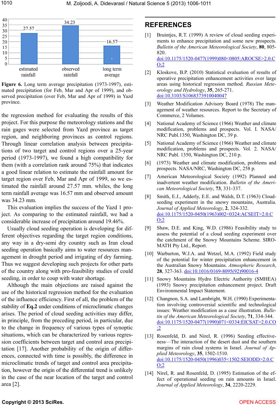
In Iran, some studies have already been developed on
evaluation of cloud seeding operations. Regarding the
reports of the “Iran National Research Centre of Cloud
Seeding Studies” in Yazd province, the cloud seeding
project in 2008-2009 over Zagros mountain chain resulted
in an increase of precipitation about 18.9%. Meantime
the results of cloud seeding over 2008-2009 in central
plain of Iran indicated 19.5% of precipitation increase.
Through an impact assessment study on cloud seeding
operation over Gavekhoni Watershed (in central Iran) in
Feb 2010, using historical regression method, an increase
of precipitation about 46.4% has been estimated [15].
Khalili et al. (2009) took under consideration the results
derived through cloud seeding operations in Iran during
1999-2007 [16]. Based on their analyzes, the cloud seed-
ing operations over central parts of Iran caused increase
of seasonal precipitation around 22% - 40%.
2. MATERIALS AND METHODS
To estimate the effect of seeding it is necessary to es-
timate the long-range average of seeded precipitation in
the contracted target, a sample of which is directly
available, and also the similar long-range average of
what would have fallen without seeding, for which no
direct data exist. Thus, this latter estimation must be in-
direct and involves two arbitrary choices. One is the
choice of the so-called “historical period” when there
was no seeding. The other is the arbitrary choice of the
so-called “control” area. The reader will notice that the
precise meaning of “target” and “control area” is two sets
of rain gauges functioning in the two localities. When
these two choices are made, the observed historical pre-
cipitation amounts, averaged over gauges in the target
and in the control areas, are used to estimate the linear
regression equation of the historical target precipitation
on that in the control. Next, this historical regression line
and the operational period’s precipitation in the control
are used to estimate the mean precipitation in target to be
expected without seeding.
In this work we have applied the historical regression
method to find the success or un-success of the cloud
seeding over Yazd province in 1999. The historical re-
gression, is recounted the most usual applicable method
to assess the cloud seeding results. This method is based
on principal factors which would be affected by cloud
seeding (such as: precipitation or snow). Data series of
the principal factors through a long term (for example 25
years) should be analyzed.
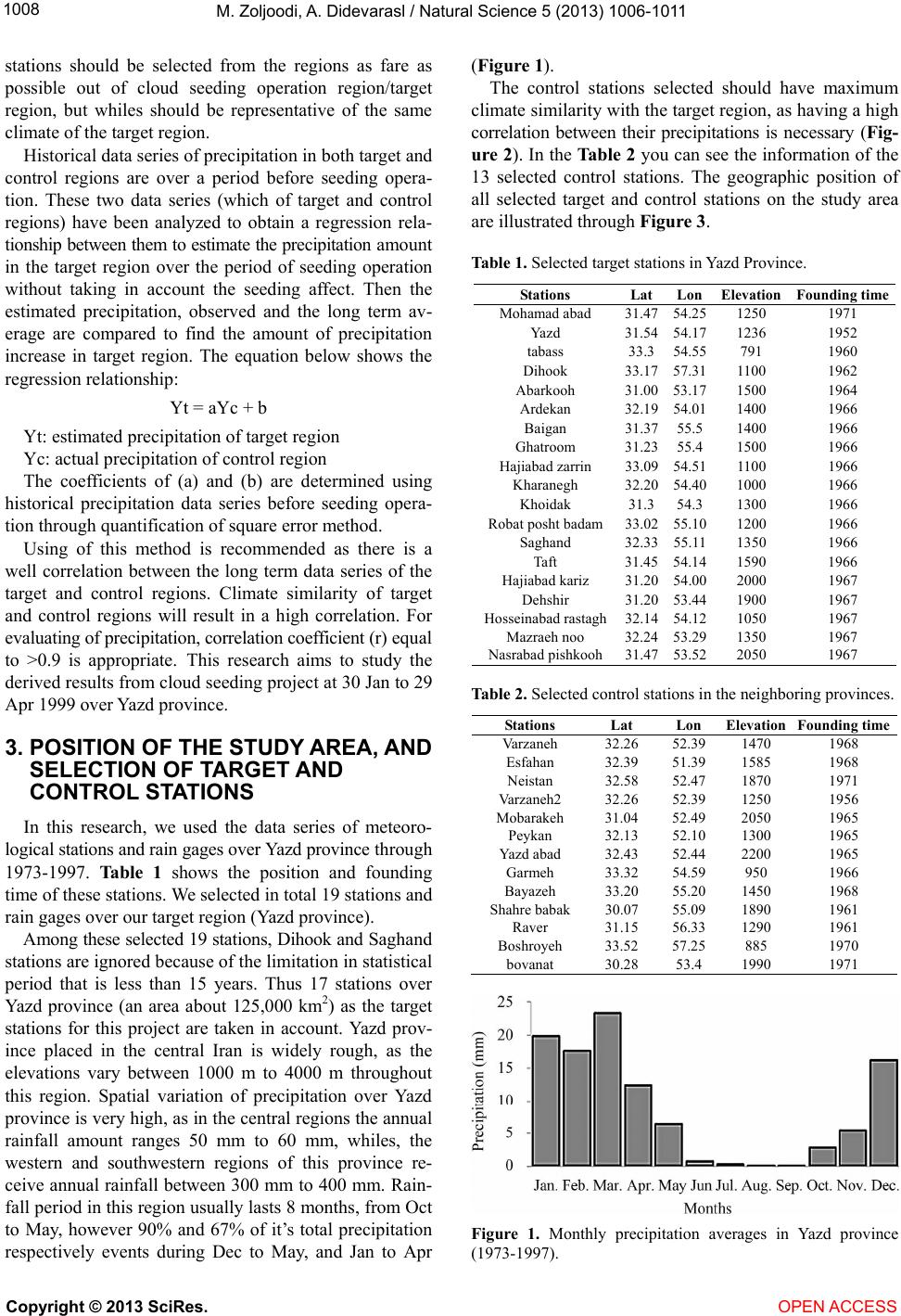
For data gathering in this regard we chose two groups
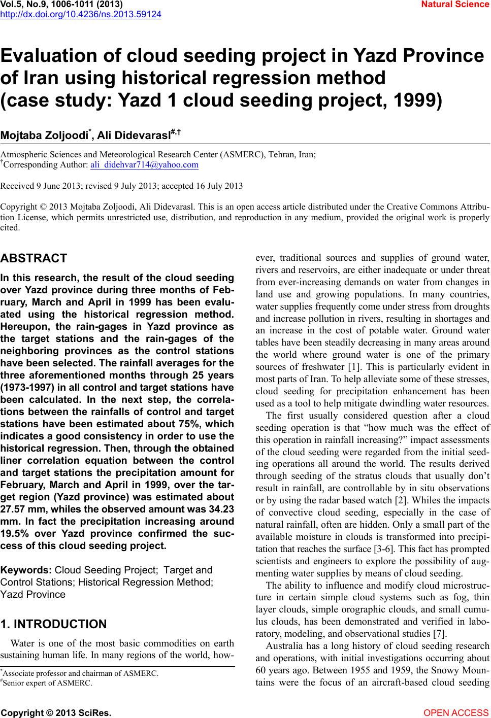
of rain gages as target and control stations. The control
Copyright © 2013 SciRes. OPEN ACCESS
M. Zoljoodi, A. Didev arasl / Natural Science 5 (2013) 10 06-1011
1008
stations should be selected from the regions as fare as
possible out of cloud seeding operation region/target
region, but whiles should be representative of the same
climate of the target region.
Historical data series of precipitation in both target and
control regions are over a period before seeding opera-
tion. These two data series (which of target and control
regions) have been analyzed to obtain a regression rela-
tionship between them to estimate the precipitation amount
in the target region over the period of seeding operation
without taking in account the seeding affect. Then the
estimated precipitation, observed and the long term av-
erage are compared to find the amount of precipitation
increase in target region. The equation below shows the
regression relationship:
Yt = aYc + b
Yt: estimated precipitation of target region
Yc: actual precipitation of control region
The coefficients of (a) and (b) are determined using
historical precipitation data series before seeding opera-
tion through quantification of square error method.
Using of this method is recommended as there is a
well correlation between the long term data series of the
target and control regions. Climate similarity of target
and control regions will result in a high correlation. For
evaluating of precipitation, correlation coefficient (r) equal
to >0.9 is appropriate. This research aims to study the
derived results from cloud seeding project at 30 Jan to 29
Apr 1999 over Yazd province.
3. POSITION OF THE STUDY AREA, AND
SELECTION OF TARGET AND
CONTROL STATIONS
In this research, we used the data series of meteoro-
logical stations and rain gages over Yazd province through
1973-1997. Table 1 shows the position and founding
time of these stations. We selected in total 19 stations and
rain gages over our target region (Yazd province).
Among these selected 19 stations, Dihook and Saghand
stations are ignored because of the limitation in statistical
period that is less than 15 years. Thus 17 stations over
Yazd province (an area about 125,000 km2) as the target
stations for this project are taken in account. Yazd prov-
ince placed in the central Iran is widely rough, as the
elevations vary between 1000 m to 4000 m throughout
this region. Spatial variation of precipitation over Yazd
province is very high, as in the central regions the annual
rainfall amount ranges 50 mm to 60 mm, whiles, the
western and southwestern regions of this province re-
ceive annual rainfall between 300 mm to 400 mm. Rain-
fall period in this region usually lasts 8 months, from Oct
to May, however 90% and 67% of it’s total precipitation
respectively events during Dec to May, and Jan to Apr
(Figure 1).
The control stations selected should have maximum
climate similarity with the target region, as having a high
correlation between their precipitations is necessary (Fig-
ure 2). In the Tabl e 2 you can see the information of the
13 selected control stations. The geographic position of
all selected target and control stations on the study area
are illustrated through Figure 3.
Table 1. Selected target stations in Yazd Province.
Stations LatLon Elevation Founding time
Mohamad abad 31.4754.25 1250 1971
Yazd 31.5454.17 1236 1952
tabass 33.354.55 791 1960
Dihook 33.1757.31 1100 1962
Abarkooh 31.0053.17 1500 1964
Ardekan 32.1954.01 1400 1966
Baigan 31.3755.5 1400 1966
Ghatroom 31.2355.4 1500 1966
Hajiabad zarrin 33.0954.51 1100 1966
Kharanegh 32.2054.40 1000 1966
Khoidak 31.354.3 1300 1966
Robat posht badam 33.0255.10 1200 1966
Saghand 32.3355.11 1350 1966
Taft 31.4554.14 1590 1966
Hajiabad kariz 31.2054.00 2000 1967
Dehshir 31.2053.44 1900 1967
Hosseinabad rastagh32.1454.12 1050 1967
Mazraeh noo 32.2453.29 1350 1967
Nasrabad pishkooh 31.4753.52 2050 1967
Table 2. Selected control stations in the neighboring provinces.
Stations Lat Lon Elevation Founding time
Varzaneh 32.26 52.39 1470 1968
Esfahan 32.39 51.39 1585 1968
Neistan 32.58 52.47 1870 1971
Varzaneh2 32.26 52.39 1250 1956
Mobarakeh 31.04 52.49 2050 1965
Peykan 32.13 52.10 1300 1965
Yazd abad 32.43 52.44 2200 1965
Garmeh 33.32 54.59 950 1966
Bayazeh 33.20 55.20 1450 1968
Shahre babak 30.07 55.09 1890 1961
Raver 31.15 56.33 1290 1961
Boshroyeh 33.52 57.25 885 1970
bovanat 30.28 53.4 1990 1971
Figure 1. Monthly precipitation averages in Yazd province
(1973-1997).
Copyright © 2013 SciRes. OPEN ACCESS
M. Zoljoodi, A. Didev arasl / Natural Science 5 (2013) 10 06-1011 1009
Figure 2. Monthly precipitation averages in the control region
(1973-1997).
Figure 3. Position of the selected target and control stations in
the study area.
4. RESULTS
As mentioned before, the period of implementing this
could seeding project is during 30 Jan to 29 Apr 1999
over Yazd province. Thus in order to obtain a regression
relation between long term average of precipitation of
control and target stations, the long term precipitation
averages for Feb, Mar and Apr in two target and control
regions before seeding operation (1973-1997) have been
calculated and used.
The Figure 4 compares the long term precipitation
variations of two control and target regions in 3 afore-
mentioned months over 1973-1997. As it is evident by
the graph below we can expect to find a high correlation
between these two regions regarding precipitation varia-
tions.
By using the long term average of precipitation in two
target and control regions the below regression equation
has been obtained:
Y = 0.722x 0.389
Figure 5 illustrates the linear correlation of precipita-
tion for two study regions during 25 years. The correla-
Figure 4. Yearly variations of the average precipitation of 3
months (Feb, Mar and Apr) during 1973-1997, in the target and
control regions (respectively blue and red curves).
Figure 5. Linear correlation of average precipitation of 3
months (Feb, Mar and Apr) between control and target regions
during 1973-1997.
tion rank is estimated about 75%, which indicates the
fact that the control stations appropriately have been se-
lected.
Figure 6 shows the observed, estimated and long term
average precipitations in our target region, comparing
them gives interesting information about the result of
seeding operation.
Through the obtained regression equation, the rainfall
amount in target region over Feb-Apr 1999, has been
estimated about 27.57 mm, whiles comparing to the ob-
served rainfall amount that was 34.23 mm, we found an
increase of rainfall around 19.46% through cloud seeding
in Yazd province.
5. CONCLUSIONS
Cloud seeding is recounted one of operational and
emergency ways to coup with drought as well as water
shortage over a specific period and a given region. Im-
plementation of cloud seeding project and increasing of
rainfall amount considerably depend on cloud sort (for
example the conductive clouds are suitable to be seeded)
and atmospheric conditions. Yazd 1 project was a cloud
seeding operation in Yazd province over February, March
and April of 1999, that was operated by Iran National
Center of Cloud Seeding Researches and Studies. We used
Copyright © 2013 SciRes. OPEN ACCESS
M. Zoljoodi, A. Didev arasl / Natural Science 5 (2013) 10 06-1011
1010
Figure 6. Long term average precipitation (1973-1997), esti-
mated precipitation (for Feb, Mar and Apr of 1999), and ob-
served precipitation (over Feb, Mar and Apr of 1999) in Yazd
province.
the regression method for evaluating the results of this
project. For this purpose the meteorology stations and the
rain gages were selected from Yazd province as target
region, and neighboring provinces as control regions.
Through linear correlation analysis between precipita-
tions of two target and control regions over a 25-year
period (1973-1997), we found a high compatibility for
them (with a correlation rank around 75%) that indicates
a good linear relation to estimate the rainfall amount for
target region over Feb, Mar and Apr of 1999, so we es-
timated the rainfall around 27.57 mm. whiles, the long
term rainfall average was 16.57 mm and observed amount
was 34.23 mm.
This evaluation implies the success of the Yazd 1 pro-
ject. As comparing to the estimated rainfall, we had a
considerable increase of precipitation around 19.46%.
Usually cloud seeding operation is developing for dif-
ferent objectives regarding the target region conditions,
any way in a dry-semi dry country such as Iran cloud
seeding operation basically aims to water resources man-
agement in drought period and irrigating of dry farming.
Thus we suggest developing such projects for other parts
of the country along with pro-feasibility studies of could
seeding, in order to coup with water shortage.
Although the main objections are raised against the
use of the historical regression method for the evaluation
of the influence efficiency. First of all, the problem of the
stability of Eq.2 under conditions of microclimatic changes
arises. The period of cloud seeding activities may differ,
in principle, from the preceding period, in particular, due
to the change in frequency of various types of synoptic
situations, which can be characterized by various regres-
sion coefficients between target and control area precipi-
tation [17]. Another probability of the origin of differ-
ences, connected with time is possibly, the difference in
microclimatic trends of target and control area precipita-
tion, however the origin of the differential trend is unlikely
in the case of the near location of the target and control
area [2].
REFERENCES
[1] Bruintjes, R.T. (1999) A review of cloud seeding experi-
ments to enhance precipitation and some new prospects.
Bulletin of the American Meteorological Society, 80, 805-
820.
doi:10.1175/1520-0477(1999)080<0805:AROCSE>2.0.C
O;2
[2] Kloskove, B.P. (2010) Statistical evaluation of results of
operative precipitation enhancement activities over large
areas using historical regression method. Russian Mete-
orology and Hydrology, 35, 265-271.
doi:10.3103/S1068373910040047
[3] Weather Modification Advisory Board (1978) The man-
agement of weather resources. Report to the Secretary of
Commerce, 2 Volumes.
[4] National Academy of Science (1966) Weather and climate
modification, problems and prospects. Vol. I. NASA/
NRC Publ.1350, Washington DC, 39 p.
[5] National Academy of Science (1966) Weather and climate
modification, problems and prospects. Vol. 2. NASA/
NRC Publ. 1350, Washington DC, 210 p.
[6] (1973) Weather and climate modification, problems and
prospects. NASA/NRC, Washington DC, 258 p.
[7] American Meteorological Society (1992) Planned and
inadvertent weather modification. Bulletin of the Ameri-
can Meteorological Society, 73, 331-337.
[8] Smith, E.J., Adderly, E.E. and Walsh, D.T. (1963) Cloud-
seeding experiment in the snowy mountains, Australia.
Journal of Applied Meteorology, 2, 324-332.
doi:10.1175/1520-0450(1963)002<0324:ACSEIT>2.0.C
O;2
[9] Shaw, D.E. and King, W.D. (1986) Feasibility study to
assess the potential of a cloud seeding experiment over
the catchment of the Snowy Mountains Scheme. SIRO-
MATH Pty Ltd., Report.
[10] Warburton, W.J.A. and Wetzel, M.A. (1992) Field study
of the potential for winter precipitation enhancement in
the Australian Snowy Mountains. Atmospheric Research,
28, 327-363. doi:10.1016/0169-8095(92)90016-4
[11] Snowy Mountains Hydro Electric Authority (SMHEA)
(1993) Snowy precipitation enhancement project. Draft
Environmental Impact Statement.
[12] Changnon, S.A. and Lambright, W.H. (1990) Experimenta-
tion involving controversial scientific and technological
issues: Weather modification as a case illustration. Bulle-
tin of the American Meteorological Society, 71, 334-344.
doi:10.1175/1520-0477(1990)071<0334:EICSAT>2.0.CO
;2
[13] Rosenfeld, D. and Nirel, R. (1996) Seeding effective-
ness—The interaction of the desert dust and the southern
margins of rain cloud systems in Israel. Journal of Ap-
plied Meteorology, 35, 1502-1510.
doi:10.1175/1520-0450(1996)035<1502:SEIODD>2.0.C
O;2
[14] Nirel, R. and Rosenfeld, D. (1995) Estimation of the ef-
fect of operational seeding on rain amounts in Israel.
Journal of Applied Meteorology, 34, 2220-2229.
Copyright © 2013 SciRes. OPEN ACCESS
M. Zoljoodi, A. Didev arasl / Natural Science 5 (2013) 10 06-1011
Copyright © 2013 SciRes. OPEN ACCESS
1011
doi:10.1175/1520-0450(1995)034<2220:EOTEOO>2.0.C
O;2
[15] Iran National Research Centre of Cloud Seeding Studies
(2010) Enhancement of water extraction over Gavekhoni
watershed through cloud seeding operation.
[16] Khalili Sr., M., Seidhassani, M., Golkar, F. and Khatibi, V.
(2009) Results of cloud seeding operations for precipita-
tion enhancement in Iran during 1999-2007. National
Cloud Seeding Research Center, Yazd.
[17] Neyman, J. (1967) Experimentation with weather control.
Journals of the Royal Statistical Society, Series A, 130,
285-326.