L. K. NING ET AL.
Copyright © 2013 SciRes. JWARP
473
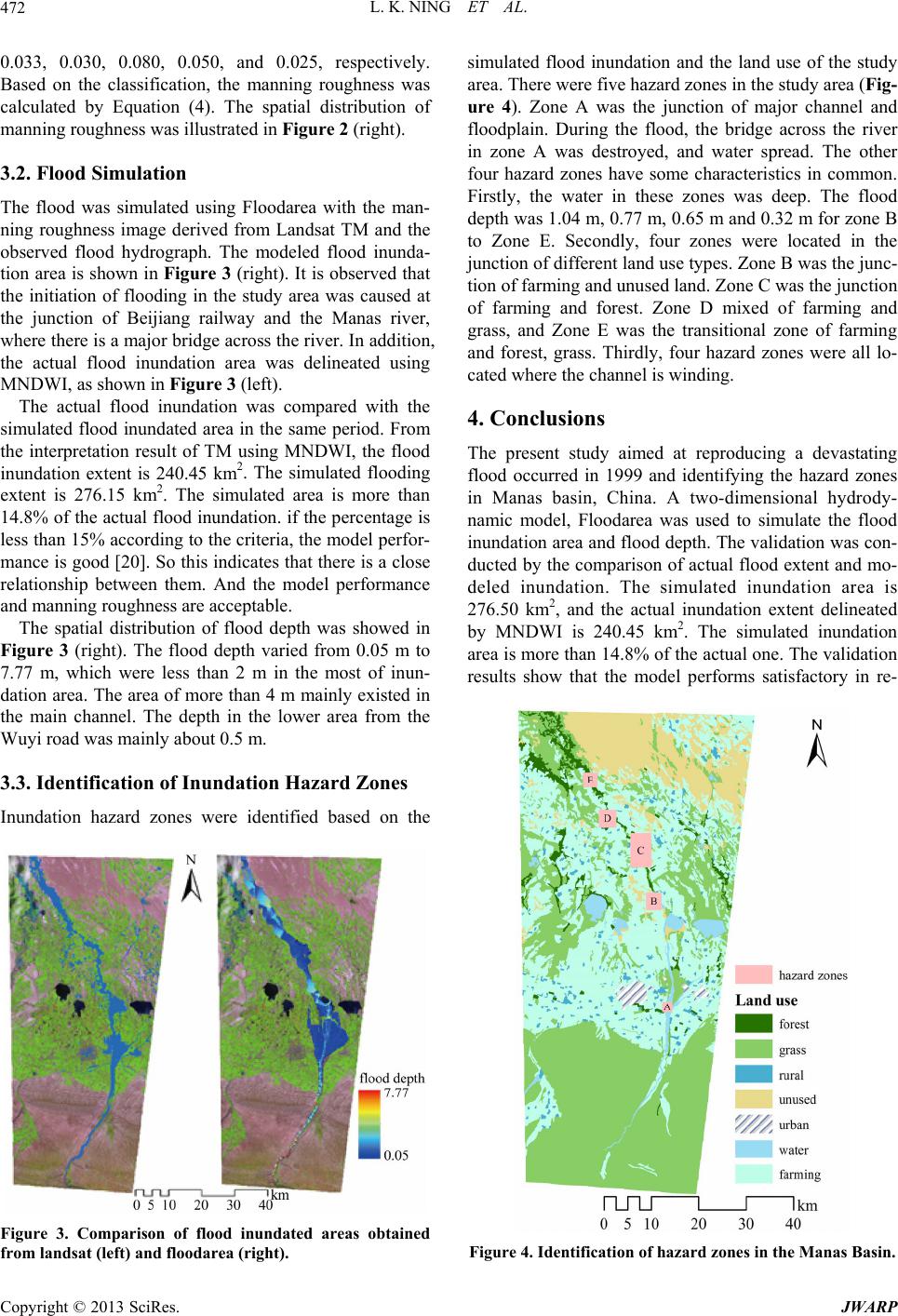
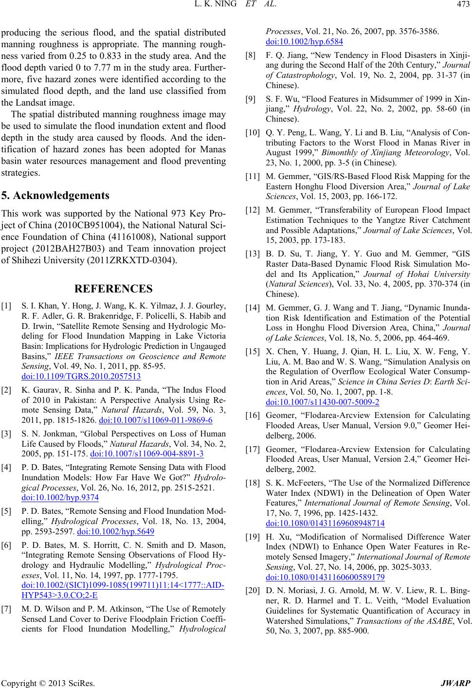
producing the serious flood, and the spatial distributed
manning roughness is appropriate. The manning rough-
ness varied from 0.25 to 0.833 in the study area. And the
flood depth varied 0 to 7.77 m in the study area. Further-
more, five hazard zones were identified according to the
simulated flood depth, and the land use classified from
the Landsat image.
The spatial distributed manning roughness image may
be used to simulate the flood inundation extent and flood
depth in the study area caused by floods. And the iden-
tification of hazard zones has been adopted for Manas
basin water resources management and flood preventing
strategies.
5. Acknowledgements
This work was supported by the National 973 Key Pro-
ject of China (2010 CB951004), the National Natur al Sci-
ence Foundation of China (41161008), National support
project (2012BAH27B03) and Team innovation project
of Shihezi University (2011ZRKXTD-0304).
REFERENCES
[1] S. I. Khan, Y. Hong, J. Wang, K. K. Yilmaz, J. J. Gourley ,
R. F. Adler, G. R. Brakenridge, F. Policelli, S. Habib a nd
D. Irwin, “Satellite Remote Sensing and Hydrologic Mo-
deling for Flood Inundation Mapping in Lake Victoria
Basin: Implications for Hy drologi c Prediction in Ung aug ed
Basins,” IEEE Transactions on Geoscience and Remote
Sensing, Vol. 49, No. 1, 2011, pp. 85-95.
doi:10.1109/TGRS.2010.2057513
[2] K. Gaurav, R. Sinha and P. K. Panda, “The Indus Flood
of 2010 in Pakistan: A Perspective Analysis Using Re-
mote Sensing Data,” Natural Hazards, Vol. 59, No. 3,
2011, pp. 1815-1826. doi:10.1007/s11069-011-9869-6
[3] S. N. Jonkman, “Global Perspectives on Loss of Human
Life Caused by Floods,” Natural Hazards, Vol. 34, No. 2,
2005, pp. 151-175. doi:10.1007/s11069-004-8891-3
[4] P. D. Bates, “Integrating Remote Sensing Data with Flood
Inundation Models: How Far Have We Got?” Hydrolo-
gical Processes, Vol. 26, No. 16, 2012, pp. 2515-2521.
doi:10.1002/hyp.9374
[5] P. D. Bates, “Remote Sensing and Flood Inundation Mod-
elling,” Hydrological Processes, Vol. 18, No. 13, 2004,
pp. 2593-2597. doi:10.1002/hyp.5649
[6] P. D. Bates, M. S. Horritt, C. N. Smith and D. Mason,
“Integrating Remote Sensing Observations of Flood Hy-
drology and Hydraulic Modelling,” Hydrological Proc-
esses, Vol. 11, No. 14, 1997, pp. 1777-1795.
doi:10.1002/(SICI)1099-1085(199711)11:14<1777::AID-
HYP543>3.0.CO;2-E
[7] M. D. Wilson and P. M. Atkinson, “The Use of Remotely
Sensed Land Cover to Derive Floodplain Friction Coeffi-
cients for Flood Inundation Modelling,” Hydrological
Processes, Vol. 21, No. 26, 2007, pp. 3576-3586.
doi:10.1002/hyp.6584
[8] F. Q. Jiang, “New Tendency in Flood Disasters in Xinji-
ang during the Second Half of the 20th Century,” Journal
of Catastrophology, Vol. 19, No. 2, 2004, pp. 31-37 (in
Chinese).
[9] S. F. Wu, “Flood Features in Midsummer of 1999 in Xin-
jiang,” Hydrology, Vol. 22, No. 2, 2002, pp. 58-60 (in
Chinese).
[10] Q. Y. Peng, L. Wang, Y. Li and B. Liu, “Analy sis of Co n-
tributing Factors to the Worst Flood in Manas River in
August 1999,” Bimonthly of Xinjiang Meteorology, Vol.
23, No. 1, 2000, pp. 3-5 (in Chinese).
[11] M. Gemmer, “GIS/RS-Based Flood Risk Mapping for the
Eastern Honghu Flood Diversion Area,” Journal of Lake
Sciences, Vol. 15, 2003, pp. 166-172.
[12] M. Gemmer, “Transferability of European Flood Impact
Estimation Techniques to the Yangtze River Catchment
and Possible Adaptations,” Journal of Lake Sciences, Vol.
15, 2003, pp. 173-183.
[13] B. D. Su, T. Jiang, Y. Y. Guo and M. Gemmer, “GIS
Raster Data-Based Dynamic Flood Risk Simulation Mo-
del and Its Application,” Journal of Hohai University
(Natural Sciences), Vol. 33, No. 4, 2005, pp. 370-374 (in
Chinese).
[14] M. Gemmer, G. J. Wang and T. Jiang, “Dynamic Inunda-
tion Risk Identification and Estimation of the Potential
Loss in Honghu Flood Diversion Area, China,” Journal
of Lake Sciences, Vol. 18, No. 5, 2006, pp. 464-469.
[15] X. Chen, Y. Huang, J. Qian, H. L. Liu, X. W. Feng, Y.
Liu, A. M. Bao and W. S. Wang, “Simulation Analysis on
the Regulation of Overflow Ecological Water Consump-
tion in Arid Areas,” Science in China Series D: Earth Sci-
ences, Vol. 50, No. 1, 2007, pp. 1-8.
doi:10.1007/s11430-007-5009-2
[16] Geomer, “Flodarea-Arcview Extension for Calculating
Flooded Areas, User Manual, Version 9.0,” Geomer Hei-
delberg, 2006.
[17] Geomer, “Flodarea-Arcview Extension for Calculating
Flooded Areas, User Manual, Version 2.4,” Geomer Hei-
delberg, 2002.
[18] S. K. McFeeters, “The Use of the Normalized Difference
Water Index (NDWI) in the Delineation of Open Water
Features,” International Journal of Remote Sensing, Vol.
17, No. 7, 1996, pp. 1425-1432.
doi:10.1080/01431169608948714
[19] H. Xu, “Modification of Normalised Difference Water
Index (NDWI) to Enhance Open Water Features in Re-
motely Sensed Imagery,” International Journal of Remote
Sensing, Vol. 27, No. 14, 2006, pp. 3025-3033.
doi:10.1080/01431160600589179
[20] D. N. Moriasi, J. G. Arnold, M. W. V. Liew, R. L. Bing-
ner, R. D. Harmel and T. L. Veith, “Model Evaluation
Guidelines for Systematic Quantification of Accuracy in
Watershed Simulations,” Transactions of the ASABE, Vol.
50, No. 3, 2007, pp. 885-900.