 Journal of Water Resource and Protection, 2013, 5, 414-426 http://dx.doi.org/10.4236/jwarp.2013.54041 Published Online April 2013 (http://www.scirp.org/journal/jwarp) Environmental Assessment of Natural & Anthr opogenic Hazards and Impact on Seawater Desalination along Red Sea Coast of Saudi Arabia Omar Siraj Aburizaiza1, Nayyer Alam Zaigham1*, Zeeshan A. Nayyar2, Gohar A. Mahar1, Azhar Siddiq1,2, Sabahat Noor1 1Unit for Ain Zubaida Rehabilitation & Groundwater Research, King Abdulaziz University, Jeddah, KSA 2University of Karachi, Karachi, Pakistan Email: *nazaigham@gmail.com Received January 30, 2013; revised March 3, 2013; accepted March 14, 2013 Copyright © 2013 Omar Siraj Aburizaiza et al. This is an open access article distributed under the Creative Commons Attribution License, which permits unrestricted use, distribution, and reproduction in any medium, provided the original work is properly cited. ABSTRACT The major part of the eastern coastline of Red Sea belongs to Saudi Arabia, which provid es great potential for desalina- tion activities, but not entirely free of risk as in general it is not environment-friendly. In recent years, the rapid urbani- zation processes on west coast of Kingdom have resulted in substantial growth of commercial and industrial centers that added to more water demand. As a consequence, reliance on desalinated water has increased markedly over the last few decades. As a leading producer of desalinated water, Saudi Arabia used to process more than 3.29 million m3/day from its plants along the Red Sea coast. At the same ti me, any ad equate b ackup plan lack s to meet regu lar water demand ( s) in case of unforeseen emergencies. Present integrated research studies have identified some of the natural and anthropo- genic hazards, which may pose major threats to quality of seawater as well as to the desalination facilities themselves. In view of these hazardous conditions, the overwhelming dependence on seawater desalination appears to be in jeop- ardy and may affect water management strategy and future socioeconomic development. It is therefore suggested the need of alternate options for cultivation of standby water resources and other management strategies parallel to the seawater desalination on similar priorities. Keywords: Natural Hazards; Red Sea; Desalination; Water Management; Saudi Arabia 1. Introduction In recent years, Saudi Arabia has become the leading producer of desalinated water from the Red Sea [1]. In the wake of the first operations, progress in the field of desalination remained gradual for a time, but has accel- erated rapidly in recent years [2,3] and thus, desalination activities were unilaterally given priority. Desalinated Red Sea water is now the main source of domestic water supply in the western parts of Saudi Arabia. In addition to the coastal cities of Jeddah, Yanbu, Jizan, Al-Wajh and others several interior ones, such as Makkah, Madina, Taif, Albaha as well as their surrounding areas, are be- coming increasingly dependent on desalinated water. This trend represents a drastic shift from the conventional groundwater supply sources. Interestingly, the inventory data of the International Desalination Association (IDA) show that there has been an explosion in the demand for further major expansion of desalination facilities in the Red Sea region. This de- mand is caused by natural growth processes of modern development, by migration from rural to urban areas and by the increase in the number of pilgrims visiting the Holy Places. For example, the population of Saudi Ara- bia has increased from 22.68 million in 2004 to more than 27.14 million in 2010 during last five years [4,5]. Likewise, the number of pilgrims has risen from 90,662 in 1923 to more than 3 million in 2010 [6]. During the last decade, multiple research delineating temporal variations in the physical and chemical charac- teristic parameters of the Red Sea was carried out to study the impact of desalin ation on the seawater. Results of these studies identified significant adverse environ- mental degradation causing deterioration to the seawaters, the coastlines, and the prevailing aquatic marine ecosys- *Corresponding a uthor. C opyright © 2013 SciRes. JWARP 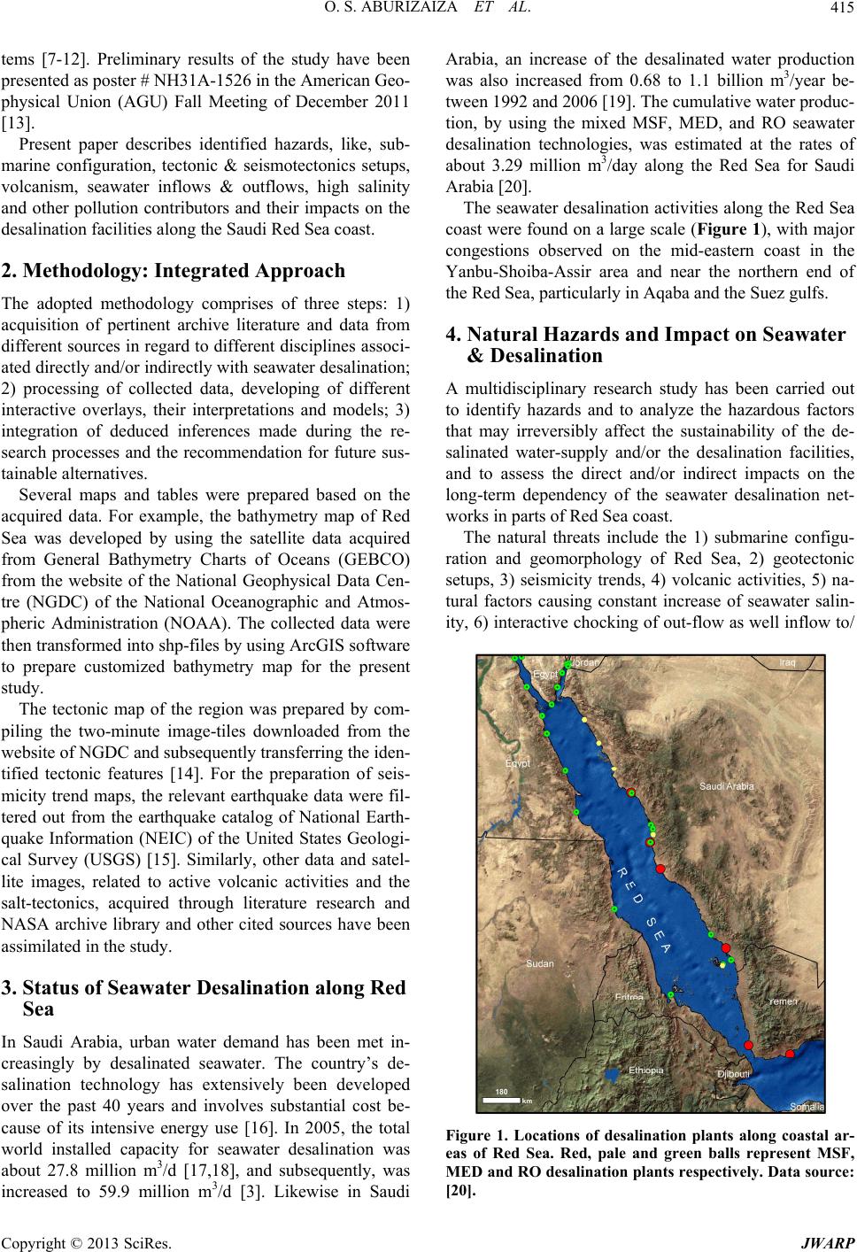 O. S. ABURIZAIZA ET AL. 415 tems [7-12]. Preliminary results of the study have been presented as po ster # NH31A-1526 in the American Geo- physical Union (AGU) Fall Meeting of December 2011 [13]. Present paper describes identified hazards, like, sub- marine configuration, tectonic & seismotectonics setups, volcanism, seawater inflows & outflows, high salinity and other pollution contributors and their impacts on the desalination facilities along the Saudi Red Sea coast. 2. Methodology: Integrated Approach The adopted methodology comprises of three steps: 1) acquisition of pertinent archive literature and data from different sources in regard to different disciplines associ- ated directly and/or indirectly with seawater desalination; 2) processing of collected data, developing of different interactive overlays, their interpretations and models; 3) integration of deduced inferences made during the re- search processes and the recommendation for future sus- tainable alternatives. Several maps and tables were prepared based on the acquired data. For example, the bathymetry map of Red Sea was developed by using the satellite data acquired from General Bathymetry Charts of Oceans (GEBCO) from the website of the National Geophysical Data Cen- tre (NGDC) of the National Oceanographic and Atmos- pheric Administration (NOAA). The collected data were then transformed into shp-files by using ArcGIS software to prepare customized bathymetry map for the present study. The tectonic map of the region was prepared by com- piling the two-minute image-tiles downloaded from the website of NGDC and subsequently transferring the iden- tified tectonic features [14]. For the preparation of seis- micity trend maps, the relevant earthquake data were fil- tered out from the earthquake catalog of National Earth- quake Information (NEIC) of the United States Geologi- cal Survey (USGS) [15]. Similarly, other data and satel- lite images, related to active volcanic activities and the salt-tectonics, acquired through literature research and NASA archive library and other cited sources have been assimilated in the study. 3. Status of Seawater Desa li n at io n al on g Re d Sea In Saudi Arabia, urban water demand has been met in- creasingly by desalinated seawater. The country’s de- salination technology has extensively been developed over the past 40 years and involves substantial cost be- cause of its intensive energy use [16]. In 2005, the total world installed capacity for seawater desalination was about 27.8 million m3/d [17,18], and subsequently, was increased to 59.9 million m3/d [3]. Likewise in Saudi Arabia, an increase of the desalinated water production was also increased from 0.68 to 1.1 billion m3/year be- tween 1992 and 2006 [19]. The cumulative water produc- tion, by using the mixed MSF, MED, and RO seawater desalination technologies, was estimated at the rates of about 3.29 million m3/day along the Red Sea for Saudi Arabia [20]. The seawater desalination activities along the Red Sea coast were found on a large scale (Figure 1), with major congestions observed on the mid-eastern coast in the Yanbu-Shoiba-Assir area and near the northern end of the Red Sea, particularly in Aqaba and the Suez gulfs. 4. Natural Hazards and Impact on Seawater & Desalination A multidisciplinary research study has been carried out to identify hazards and to analyze the hazardous factors that may irreversibly affect the sustainability of the de- salinated water-supply and/or the desalination facilities, and to assess the direct and/or indirect impacts on the long-term dependency of the seawater desalination net- works in parts of Red Sea coast. The natural threats include the 1) submarine configu- ration and geomorphology of Red Sea, 2) geotectonic setups, 3) seismicity trends, 4) volcanic activities, 5) na- tural factors causing constant increase of seawater salin- ity, 6) interactive chocking of out-flow as well inflow to/ Figure 1. Locations of desalination plants along coastal ar- eas of Red Sea. Red, pale and green balls represent MSF, MED and RO desalination plants respectively. Data source: [20]. Copyright © 2013 SciRes. JWARP  O. S. ABURIZAIZA ET AL. 416 from neighboring fresh and/or seawater sources. 4.1. Submarine Configuration and Geomorphology of Red Sea Red Sea is an enclosed and elongated narrow saline- water body, sandwiched between African continent and Arabian Peninsula, except a bottleneck opening at Bab- el-Mandeb. Thus, it is practically isolated from the open ocean. It extends for a little more than 2000 kilometers from Suez-Aqaba Gulfs in north to Strait of Bab-el-Man- deb in south that further connects with the Aden Gulf and then Indian Ocean. The Red Sea is over 300 kilometers wide parallel to latitude 16˚N. However, the general width is about 250 kilometers that particularly shows acute tapering towards south-end. The bathymetry map shows distinct depth variation of Red Sea basin (Figure 2). Maximum depth, a little less than 3000 meters is in mid-part of central axial trough of the sea. However, av- erage depth is about 500 meters. The coastal shelf may be divided into two zones. Depth of the shallowest shelf ranges between 50 meters Figure 2. Customized bathymetry map of Red Sea in rela- tion to Aden Gulf located in south, the Mediterranean Sea in the north and the enveloping countries of Red Sea. and 75 meters that is comparatively very narrow in nor- thern half of the Sea with respect to southern half. The depth of deeper shelf may extend down to 500 - 600 me- ters. In the southern half, the shallow shelf dominantly widened extending up to Bab-el-Mandeb. Moreover, the shallow shelf hosts numerous islands and fringing coral reef zones along coastal areas of the Sea. In general, the shallowest parts of Red Sea, with a depth of 50 meters, comprise 25% of its area. Some 40% is moderately shal- low at depth of 100 meters. Only 15% is considered mo- derately deep at a depth level of 1000 meters and 20% is the deeper than 1000 meters. In north, Red Sea has two closed bifurcated marine features, i.e., the Aqaba and Suez gulfs. Gulf of Suez is a shallow submarine body with depth of about 50 meters. Gulf of Aqaba, by contrast, has depth ranging between 800 meters and 1800 meters. Suez Canal is a manmade civil structure linking Mediterranean Sea to Red Sea via Gulf of Sues, which was built in 1869 for modern inter- national navigation [21], with an overall length of 193 kilometers, a depth of 180 - 205 meters and a width of 21 meters between the buoys. In south, the width of Red Sea reduces to 30 kilome- ters at Strait of Bab-El-Mandeb, where Perim Island di- vides it into two channels in between Yemen and Dji- bouti. Eastern channel is about 3 kilo meters wide and 30 meters deep, while the western cannel is about 25 kilo- meters wide and 310 meters deep. In fact, the acute nar- rowing at the Strait of Bab El-Mandeb poses a handicap by causing the chocking conditions for the re-flushing of the highly saline-water of the bottle-neck ed Red Sea ma- rine body. 4.2. Tectonic Setup Current tectonic setup of the peninsular landmass is very complex as simultaneously three tectonic forces, i.e., divergent (rifting), convergent (subduction) and shearing (transform and transcurrent faulting), are together ac- tively in progress along peripheral areas (Figure 3). In east, there is an active transform-cum-transcurrent right lateral fault system, known as “Owen Fracture Zone” growing and extending from Carlsberg Spreading Center of Indian Ocean towards the Makran coastal re- gion of Pakistan passing parallel to Arabian Peninsula within the western p art of Ar abian Sea. The Makran co as t was considered to be region of segmented subduction [22,23]. In northwest, the Peninsula is converging against the Mediterranean-Tethyan Mobile Belt at the rate of 2.4 millimeters/year [24,25]. Northwestern marg in of the Pe- ninsula is again subjected to the development of left- lateral transcurrent-fault system passing through the Gulf of Aqaba and Dead Sea and linking the Red Sea Rift ba- sin to the Mediterranean-Tethyan Mob ile belt. The western margin is typically rifted and modified Copyright © 2013 SciRes. JWARP  O. S. ABURIZAIZA ET AL. 417 Figure 3. Map shows the configuration of earth’s surface in relation to tectonic setup of Arabian Peninsula and its sur- rounding regions. Image data source: [15]. under the influence of the ongoing divergent tectonic processes, which cause growth of the Red Sea Rift basin [26,27]. Similarly, southern margin of Peninsula again is being deformed and re-modifying by divergent activities associated with the active Aden Rift. Westward, Aden Rift makes a triple junction with Red Sea and East Afri- can Rift that appears to play a major role in faster defor- mation of southern part of the Red Sea as evident from the Neotectonic volcanic eruption activities. Based on Red Sea magnetic anomaly profiles, it has been estimated that since 3.2 Ma the fastest spreading rate, about ~16 millimeters/yr, occurs near latitud e 18˚N, whereas the slowest rate, about ~10 millimeters/year, occurs at latitude 25.5˚N [28]. From differential spread- ing rates prevailing acro ss Red Sea, it is inferred that the coastal areas of Saudi Arabia are under constrain of pull- apart-cum-shearing forces causing oblique deformation along the coastal areas that needs to be incorporated in the planning of the coastal developments. Moreover, a model was worked out for the rift-asy- mmetry and contin ental uplift. The model shows that the eastern sides of most of the earth’s rift zones have higher elevation of 100 - 300 meters that affects not only the oceanic lithosphere but also the continents to the east [29]. Same model is applicable in case of Saudi Arabia that lies on the east-side of the Red Sea Rift zo ne. Based on the proposed model, it is inferred that western rifted coastal belt of Saudi Arabia is accounted for ongoing vertical as well as horizontal motions causing complex structural setup. Based on present tectonic setup of the region, it is in- ferred that the western and the southern rifts have sepa- rated Arabian Peninsula from the Afro-Arabian mega- landmass; and the eastern and northwestern translational tectonic faulting system collectively moving or drifting the Peninsular landmass towards northeast causing enor- mous compression forces on western segments of the Mediterranean-Tethyan Mobile belt, like Zagros-Thrust- System as evident from NW-trending shift of the Arabian continental landmass at an average velocity of 5 centi- meters/year [30]. In present active tectonic scenario, the re-activation of pre-existed dormant fault/fracture zone(s) is conceived that may cause displacement(s) of rock units on varying scales depending upon several geotectonic parameters and as such generating micro, macro or mega earthquakes at any time. These phenomena need continuous monitoring and evaluation of such re-activations considering the pre- sence of important civil structures, like the desalination plants developed along the coastal areas of Red Sea. 4.3. Seismotectonic Setup For a long time, Arabian Peninsula was generally con- sidered to be stable continental mass and also as one of the seismic quiescence parts of the world, but results of the present study and integrated reviews of the sporadic studies carried out during the last three decades in dif- ferent parts of the Peninsula seem to call for a reconsid- eration of the accepted view [31]. One cannot, in fact, speak of seismic quiescence any longer, as the geo-tec- tonic setups of the peripheral areas and associated seis- micity patterns show actively mobile deformational even t s under the ongoing varying tectonic processes. Moreover, it is also inferred that high magnitude disastrous intrapo- late earthquakes may occur within the stable continental crust like high magnitude ear thquake of New Madr id and Rann-Kutch of India [32,33]. In and around Red Sea, the seismicity activities are mainly controlled by the prevail- ing dominant tensional force-domain under the diver- gence processes between the African and Arabian plates. Thus, such high magnitude earthquake occurrence cannot be ruled out. Seismicity in and around Red Sea The seismic events, recorded in and around Red Sea dur- ing the last 38 years from 1973 to May 2011 [34] show that the frequency and intensity of earthquake occur- rences comparatively is moderately high, but it has also been observed that the n atural trend of increase in low to moderate earthquakes’ occurrences more or less is the same with variation in relative calmness or the temporal gaps among high magnitude earthquakes (Table 1). The empirical correlation, between the historical and modern earthquake occurrences for the periods of 1973- 1983 and 1973-May 2 011 (Figure 4), shows presence of distinct clustures and/or zones of high seismicity asso- ciated with Gulf of Aqaba and its intersection with Gulf of Sues and also with northern end of Red Sea. Similarly, the southern section of Red Sea also shows a complex Copyright © 2013 SciRes. JWARP 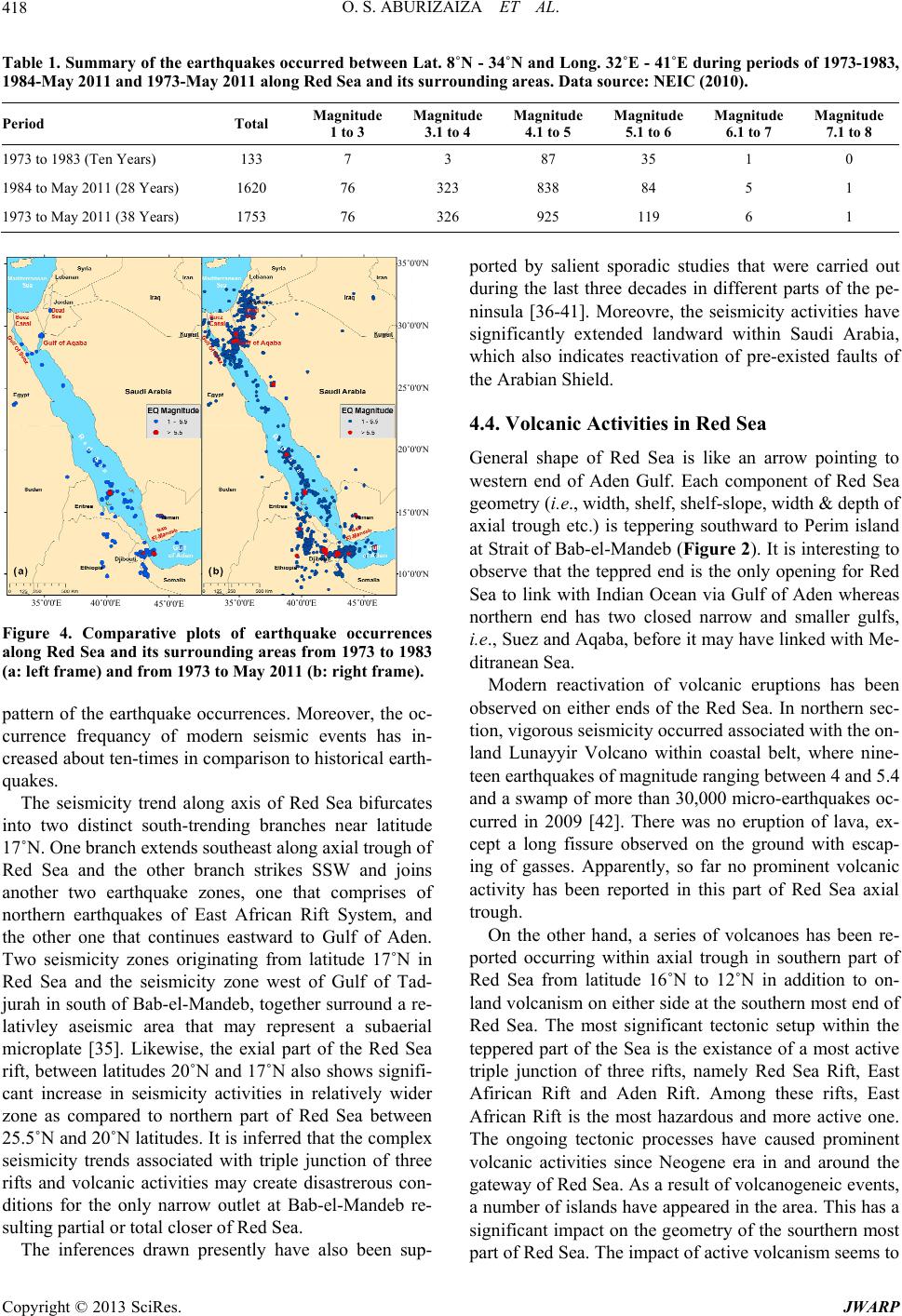 O. S. ABURIZAIZA ET AL. Copyright © 2013 SciRes. JWARP 418 Table 1. Summary of the earthquakes oc curred between Lat. 8˚N - 34˚N and Long. 32˚E - 41˚E during periods of 1973-1983, 1984-May 2011 and 1973-May 2011 along Red Sea and its surrounding areas. Data source: NEIC (2010). Period Total Magnitude 1 to 3 Magnitude 3.1 to 4 Magnitude 4.1 to 5 Magnitude 5.1 to 6 Magnitude 6.1 to 7 Magnitude 7.1 to 8 1973 to 1983 (Ten Years) 133 7 3 87 35 1 0 1984 to May 2011 (28 Yea rs) 1620 76 323 838 84 5 1 1973 to May 2011 (38 Yea rs) 1753 76 326 925 119 6 1 35˚0'0'N 30˚0'0'N 25˚0'0'N 20˚0'0'N 15˚0'0'N 10˚0'0'N 35˚0'0'E 40˚0'0'E 45˚0'0'E 35˚0'0'E 40˚0'0'E 45˚0'0'E occurrences attern of the earthquake occurrences. Moreover, the oc- ismicity trend along axis of Red Sea bifurcates in o been sup- po 4.4. Volcanic Activities in Red Sea row pointing to tivation of volcanic eruptions has been ob e other hand, a series of volcanoes has been re- po rted by salient sporadic studies that were carried out during the last three decades in different parts of the pe- ninsula [36-41]. Moreovre, the seismicity activities have significantly extended landward within Saudi Arabia, which also indicates reactivation of pre-existed faults of the Arabian Shield. General shape of Red Sea is like an ar western end of Aden Gulf. Each component of Red Sea geometry (i.e., width, shelf, shelf-slope, width & depth of axial trough etc.) is teppering southward to Perim island at Strait of Bab-el-Mandeb (Figure 2). It is interesting to observe that the teppred end is the only opening for Red Sea to link with Indian Ocean via Gulf of Aden whereas northern end has two closed narrow and smaller gulfs, i.e., Suez and Aqaba, before it may have linked with Me- ditranean Sea. Modern reac Figure 4. Comparative plots of earthquake along Red Sea and its surrounding areas from 1973 to 1983 (a: left frame) and from 1973 to May 2011 (b: right frame). served on either ends of the Red Sea. In northern sec- tion, vigorous seis micity occurred associated with the on- land Lunayyir Volcano within coastal belt, where nine- teen earthquakes of magnitude ranging between 4 and 5.4 and a swamp of more than 30,000 micro-earthquakes oc- curred in 2009 [42]. There was no eruption of lava, ex- cept a long fissure observed on the ground with escap- ing of gasses. Apparently, so far no prominent volcanic activity has been reported in this part of Red Sea axial trough. On th p currence frequancy of modern seismic events has in- creased about ten-times in comparison to historical earth- quakes. The se to two distinct south-trending branches near latitude 17˚N. One branch extends southeast along axial trough of Red Sea and the other branch strikes SSW and joins another two earthquake zones, one that comprises of northern earthquakes of East African Rift System, and the other one that continues eastward to Gulf of Aden. Two seismicity zones originating from latitude 17˚N in Red Sea and the seismicity zone west of Gulf of Tad- jurah in south of Bab-el-Mandeb, together surround a re- lativley aseismic area that may represent a subaerial microplate [35]. Likewise, the exial part of the Red Sea rift, between latitudes 20˚N and 17˚N also shows signifi- cant increase in seismicity activities in relatively wider zone as compared to northern part of Red Sea between 25.5˚N and 20˚N latitudes. It is inferred that the complex seismicity trends associated with triple junction of three rifts and volcanic activities may create disastrerous con- ditions for the only narrow outlet at Bab-el-Mandeb re- sulting partial or total closer of Red Sea. The inferences drawn presently have als rted occurring within axial trough in southern part of Red Sea from latitude 16˚N to 12˚N in addition to on- land volcanism on either side at the southern most end of Red Sea. The most significant tectonic setup within the teppered part of the Sea is the existance of a most active triple junction of three rifts, namely Red Sea Rift, East Afirican Rift and Aden Rift. Among these rifts, East African Rift is the most hazardous and more active one. The ongoing tectonic processes have caused prominent volcanic activities since Neogene era in and around the gateway of Red Sea. As a result of volcanogeneic events, a number of islands have appeared in the area. This has a significant impact on the geometry of the sourthern most part of Red Sea. The impact of activ e vo lcanism seems to 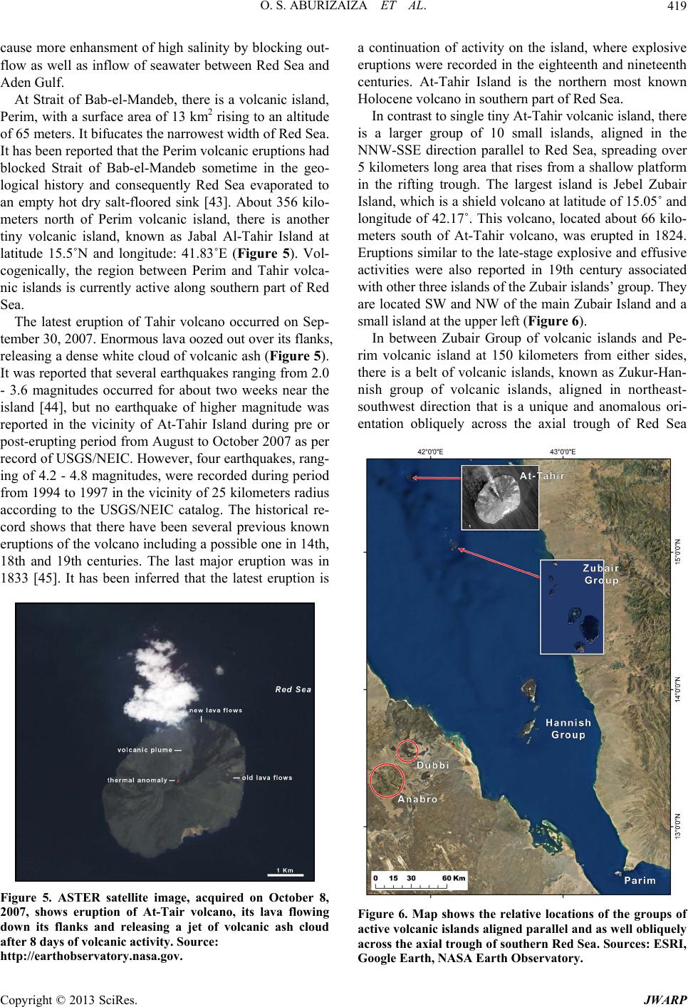 O. S. ABURIZAIZA ET AL. 419 cause more enhansment of high salinity by blocking out- flow as well as inflow of seawater between Red Sea and Aden Gulf. At Strait of Bab-el-Mandeb, there is a volcanic island, Pe n of Tahir volcano occurred on Sep- te rim, with a surface area of 13 km2 rising to an altitude of 65 meters. It bifucates the narrowest width of Red Sea. It has been reported that the Perim volcanic eruptions had blocked Strait of Bab-el-Mandeb sometime in the geo- logical history and consequently Red Sea evaporated to an empty hot dry salt-floored sink [43]. About 356 kilo- meters north of Perim volcanic island, there is another tiny volcanic island, known as Jabal Al-Tahir Island at latitude 15.5˚N and longitude: 41.83˚E (Figure 5). Vol- cogenically, the region between Perim and Tahir volca- nic islands is currently active along southern part of Red Sea. The latest eruptio mber 30, 2007. Enormous lava oozed out over its flanks, releasing a dense white cloud of volcanic ash (Figure 5). It was reported that several earthquakes ranging from 2.0 - 3.6 magnitudes occurred for about two weeks near the island [44], but no earthquake of higher magnitude was reported in the vicinity of At-Tahir Island during pre or post-eruptin g period from Augu st to October 2007 as per record of USGS/NEIC. However, four earthquakes, rang- ing of 4.2 - 4.8 magnitudes, were recorded during period from 1994 to 1997 in the vicinity of 25 kilometers radius according to the USGS/NEIC catalog. The historical re- cord shows that there have been several previous known eruptions of the volcano including a possible one in 14th, 18th and 19th centuries. The last major eruption was in 1833 [45]. It has been inferred that the latest eruption is Figure 5. ASTER satellite image, acquired on October 8, island, where explosive and, th er e is islands and Pe- rim 2007, shows eruption of At-Tair volcano, its lava flowing down its flanks and releasing a jet of volcanic ash cloud after 8 days of volcanic activity. Source: http://earthobservatory.nasa.gov. a continuation of activity on the eruptions were recorded in the eighteenth and nineteenth centuries. At-Tahir Island is the northern most known Holocene volcano in southern part of Red Sea. In contrast to single tiny At-Tah ir volcanic isl a larger group of 10 small islands, aligned in the NNW-SSE direction parallel to Red Sea, spreading over 5 kilometers long area that rises from a shallow platform in the rifting trough. The largest island is Jebel Zubair Island, which is a shield volcano at latitude of 15.05˚ and longitude of 42.17˚. This volcano, located about 66 kilo- meters south of At-Tahir volcano, was erupted in 1824. Eruptions similar to the late-stage explos ive and effusive activities were also reported in 19th century associated with other three islan ds of the Zubair islands’ group. They are located SW and NW of the main Zubair Island and a small island at the upper left (Figure 6). In between Zubair Group of volcanic volcanic island at 150 kilometers from either sides, there is a belt of volcanic islands, known as Zukur-Han- nish group of volcanic islands, aligned in northeast- southwest direction that is a unique and anomalous ori- entation obliquely across the axial trough of Red Sea Figure 6. Map shows the relative locations of the groups of active volcanic islands aligned parallel and as well obliquely across the axial trough of southern Red Sea. Sources: ESRI, Google Earth, NASA Earth Observatory. Copyright © 2013 SciRes. JWARP 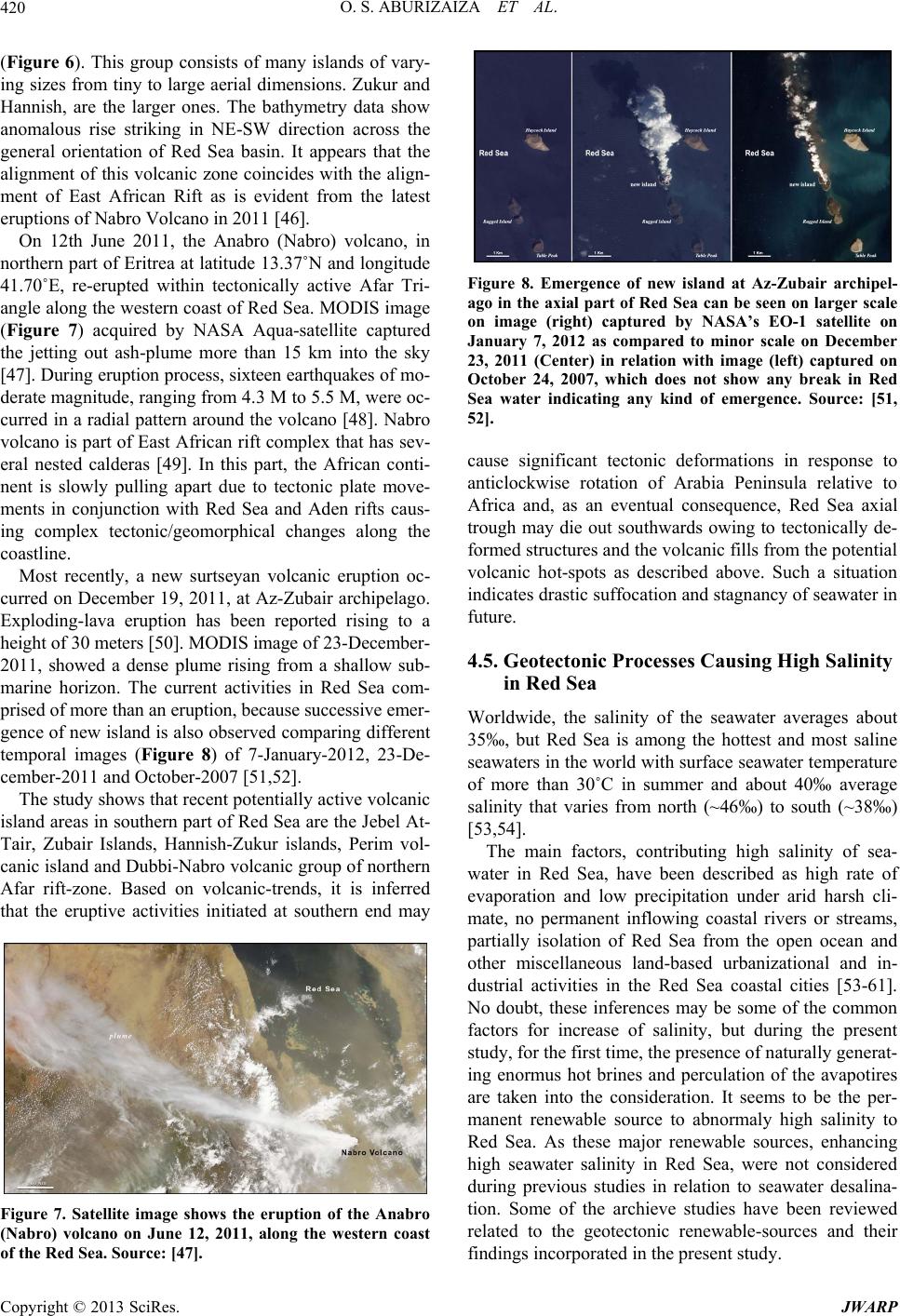 O. S. ABURIZAIZA ET AL. 420 (Figure 6). This group consists of many islands of vary- o) volcano, in no ently, a new surtseyan volcanic eruption oc- cu active volcanic is ing sizes from tiny to large aerial d imensions. Zukur and Hannish, are the larger ones. The bathymetry data show anomalous rise striking in NE-SW direction across the general orientation of Red Sea basin. It appears that the alignment of this volcanic zone coincides with the align- ment of East African Rift as is evident from the latest eruptions of Na br o V ol can o i n 20 1 1 [4 6] . On 12th June 2011, the Anabro (Nabr Figure 8. Emergence of new island at Az-Zubair archipe ause significant tectonic deformations in response to 4.5. Geotectonic Processes Causing High Salinity Worldwidity of the seawater averages about ain factors, contributing high salinity of sea- w rthern part of Eritrea at latitude 13.37˚N and longitude 41.70˚E, re-erupted within tectonically active Afar Tri- angle along the western coast of Red Sea. MODIS image (Figure 7) acquired by NASA Aqua-satellite captured the jetting out ash-plume more than 15 km into the sky [47]. During eruption process, sixteen earthquakes of mo- derate magnitude, ranging from 4.3 M to 5.5 M, were oc- curred in a radial pattern around the volcano [48]. Nabro volcano is part of East African rift complex that has sev- eral nested calderas [49]. In this part, the African conti- nent is slowly pulling apart due to tectonic plate move- ments in conjunction with Red Sea and Aden rifts caus- ing complex tectonic/geomorphical changes along the coastline. Most rec rred on December 19, 2011, at Az-Zubair archipelago. Exploding-lava eruption has been reported rising to a height of 30 meters [50]. MODIS image of 23-December- 2011, showed a dense plume rising from a shallow sub- marine horizon. The current activities in Red Sea com- prised of more than an eruption, because successive emer- gence of new island is also observed comparing different temporal images (Figure 8) of 7-January-2012, 23-De- cember-2011 and October-2007 [51,52]. The study shows that recent potentially land areas in southern part of Red Sea are the Jebel At- Tair, Zubair Islands, Hannish-Zukur islands, Perim vol- canic island and Dubbi- Nabro volcanic g roup o f nor thern Afar rift-zone. Based on volcanic-trends, it is inferred that the eruptive activities initiated at southern end may Figure 7. Satellite image shows the eruption of the Anabro (Nabro) volcano on June 12, 2011, along the western coast of the Red Sea. Source: [47]. l- ago in the axial part of Red Sea can be seen on larger scale on image (right) captured by NASA’s EO-1 satellite on January 7, 2012 as compared to minor scale on December 23, 2011 (Center) in relation with image (left) captured on October 24, 2007, which does not show any break in Red Sea water indicating any kind of emergence. Source: [51, 52]. c anticlockwise rotation of Arabia Peninsula relative to Africa and, as an eventual consequence, Red Sea axial trough may die out southwards owing to tectonically de- formed structures and the volcanic fills from the poten tial volcanic hot-spots as described above. Such a situation indicates drastic suffocation and stagnancy of seawater in future. in Red Sea e, the salin 35‰, but Red Sea is among the hottest and most saline seawaters in the world with surface seawater temperature of more than 30˚C in summer and about 40‰ average salinity that varies from north (~46‰) to south (~38‰) [53,54]. The m ater in Red Sea, have been described as high rate of evaporation and low precipitation under arid harsh cli- mate, no permanent inflowing coastal rivers or streams, partially isolation of Red Sea from the open ocean and other miscellaneous land-based urbanizational and in- dustrial activities in the Red Sea coastal cities [53-61]. No doubt, these inferences may be some of the common factors for increase of salinity, but during the present study, for the first time, the presence of naturally generat- ing enormus hot brines and perculation of the avapotires are taken into the consideration. It seems to be the per- manent renewable source to abnormaly high salinity to Red Sea. As these major renewable sources, enhancing high seawater salinity in Red Sea, were not considered during previous studies in relation to seawater desalina- tion. Some of the archieve studies have been reviewed related to the geotectonic renewable-sources and their findings incorpor ated in the present study. Copyright © 2013 SciRes. JWARP 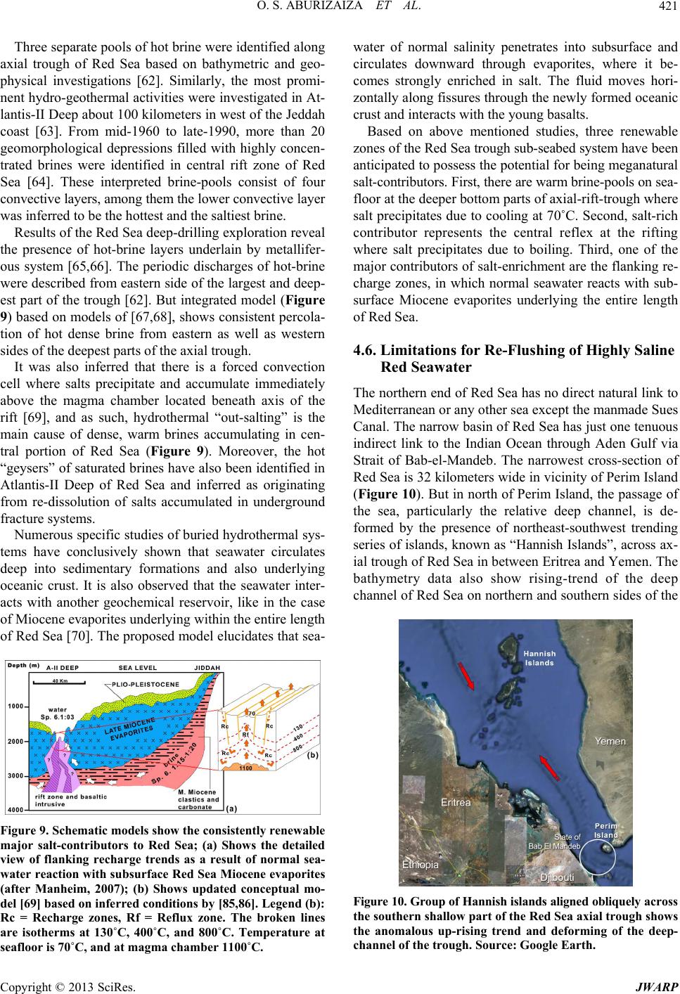 O. S. ABURIZAIZA ET AL. 421 Three separate pools of hot brine were identified along ax eal th convection ce fic studies of buried hydrothermal sys- te ial trough of Red Sea based on bathymetric and geo- physical investigations [62]. Similarly, the most promi- nent hydro-geothermal activities were investigated in At- lantis-II Deep about 100 kilometers in west of the Jeddah coast [63]. From mid-1960 to late-1990, more than 20 geomorphological depressions filled with highly concen- trated brines were identified in central rift zone of Red Sea [64]. These interpreted brine-pools consist of four convective layers, among them the lower convective layer was inferred to be the hottest and the saltiest brine. Results of the Red Sea deep-drilling exp loration rev e presence of hot-brine layers underlain by metallifer- ous system [65,66]. The periodic discharges of hot-brine were described from eastern side of the largest and deep- est part of the trough [62]. But integrated model (Figure 9) based on models of [67,68], shows consistent percola- tion of hot dense brine from eastern as well as western sides of the deepest parts of the axial trough. It was also inferred that there is a forced ll where salts precipitate and accumulate immediately above the magma chamber located beneath axis of the rift [69], and as such, hydrothermal “out-salting” is the main cause of dense, warm brines accumulating in cen- tral portion of Red Sea (Figure 9). Moreover, the hot “geysers” of saturated brines have also been iden tified in Atlantis-II Deep of Red Sea and inferred as originating from re-dissolution of salts accumulated in underground fracture systems. Numerous speci ms have conclusively shown that seawater circulates deep into sedimentary formations and also underlying oceanic crust. It is also observed that the seawater inter- acts with another geochemical reservoir, like in the case of Miocene evaporites underlying within the entire length of Red Sea [70]. The proposed model elucidates that sea- Figure 9. Schematic models show the c onsiste ntly renew a ble seafloor is 70˚C, and at magma chamber 1100˚C. tions for Re-Flushing of Highly Saline The ed Sea has no direct natural link to major salt-contributors to Red Sea; (a) Shows the detailed view of flanking recharge trends as a result of normal sea- water reaction with subsurface Red Sea Miocene evaporites (after Manheim, 2007); (b) Shows updated conceptual mo- del [69] based on inferred conditions by [85,86]. Le gend (b): Rc = Recharge zones, Rf = Reflux zone. The broken lines are isotherms at 130˚C, 400˚C, and 800˚C. Temperature at water of normal salinity penetrates into subsurface and circulates downward through evaporites, where it be- comes strongly enriched in salt. The fluid moves hori- zontally along fissures through the newly formed oceanic crust and interacts with the young basalts. Based on above mentioned studies, three renewable zones of the Red Sea trough sub-seabed system have been anticipated to possess the potential for being meganatural salt-contributors. First, there are warm brine-pools on sea- floor at the deeper bottom parts of axial-rift-trough where salt precipitates due to cooling at 70˚C. Second, salt-rich contributor represents the central reflex at the rifting where salt precipitates due to boiling. Third, one of the major contributors of salt-enrichment are the flanking re- charge zones, in which normal seawater reacts with sub- surface Miocene evaporites underlying the entire length of Red Sea. 4.6. Limita Red Seawater northern end of R Mediterranean or any other sea except the manmade Sues Canal. The narrow basin of Red Sea has just one tenuous indirect link to the Indian Ocean through Aden Gulf via Strait of Bab-el-Mandeb. The narrowest cross-section of Red Sea is 32 kilometers wide in vicinity o f Perim Island (Figure 10). But in north of Perim Island, the passage of the sea, particularly the relative deep channel, is de- formed by the presence of northeast-southwest trending series of islands, known as “Hannish Islands”, across ax- ial trough of Red Sea in between Eritrea and Yemen. The bathymetry data also show rising-trend of the deep channel of Red Sea on northern and southern sides of the Figure 10. Group of Hannish i slands aligne d obliquely a c ro s s the southern shallow part of the Red Sea axial trough shows the anomalous up-rising trend and deforming of the deep- channel of the trough. Source: Google Earth. Copyright © 2013 SciRes. JWARP  O. S. ABURIZAIZA ET AL. 422 Hannish islands’ complex as shown by “arrows”. The up- rising tectonic interference may have caused significant chocking for both interactive outflow and inflow of sur- face seawater in general and the deep seawater in par- ticular between Red Sea and Aden Gulf. It was observed that the shallowest projection over which the deep water must pass is at a depth of 137 meters in west of main Hannish Island situated about 150 kilometers NNW of Perim [71]. In the southern part, however, relatively deeper Red Sea channel shows a triangular shaped br aded channel about 12 kilometers wide flanked by broad shel- ves with ave rage dept h of 50 kilometers on either sides . The prevailing submarine geomorphic features and geotectonic uprising indicate the restricted interactive high salinity water outflow of Red Sea to Aden Gulf and the low salinity water inflow of Aden Gulf to Red Sea. Moreover, seasonal variability of flow across Bab-el- Mandeb was also observed as a result of onset of peri- odic monsoon climate [71]. During winter season, the warmer, fresher water flows into Red Sea in upper sur- face layer and the cooler, saltier water flows into Aden Gulf in lower layer. But in summer, the exchange-condi- tions become hazardous through Bab-el-Mandeb as the high salinity outflow is nearly arrested, the flow in sur- face layer is reversed, and the intermediate water from Aden Gulf flows into Red Sea between the two outflow- ing layers. 5. Anthropogenic Hazards erous adverse activi- impact on the future oned an- th ed Sea, the statistical data of Jeddah de its offshore waters. A Like natural hazards, there are num ties those may cause degradational sustainability of water-supply from the seawater-desa- lination facilities directly and/or indirectly with passage of time and/or within unpredictable sudden shorter time- span depending on the specific nature of the individual threat. The salient anthropogenic such threats, encoun- tering in Red Sea, may include 1) accidental oil spills, 2) international conflicts, 3) heavy shipping traffic causing quality deterioration of marine waters, 4) accidental and/ or sabotage activities causing uncalled for sudden and huge damages to desalinated-water supply network, 5) terrorist activities, 6) ever-increasing contribution of enor- mous brine discharges from the world’s largest networks of the desalination p lants, 7) thermal pollution due to d is- charge of hot-water that being used for cooling of certain parts of the huge industrial machines, 8) discharges of untreated and/or partially treated municipal and industrial wastes, 9) emergency maintenances replacement of da- maged pipelines of water-supply network systems, 10) recurrent increase in required energy, and costs for de- salinated water-production and maintenan ce of the plants against the desalinatio n of anticipated h ighly deteriorated seawater in near future, 11) total dependency on the out- sourced desalination techno logy in the country. In the last two decades, numerous research studies have been carried out in regards to above menti ropogenic activities cau sing adverse environmental im- pact on the Red Sea water, its biodiversitified echo-sys- tems and operational activities of the desalination plants [12,53,69,71-82]. In relation to the brine discharges from the desalina- tion plants along R salination plant is taken in to consideration as an ex am- ple. During 2011, the total inlet-flow has been estimated 6800 m3/hour (60 million m3/year) and out of this intake the production flow-rate was 2720 m3/hour (24 million m3/year) and rejected flow-rate of brine was recorded 4080 m3/hour or 36 million m3/year (M. Ettwadi, Per- sonal Communication, December 2011). The production and rejected flow rate are 35% and 65% of the total inlet-flow. Based on the equation, i.e., total inlet-flow = production-flow + rejected-flow, the rejected concen- trated brine discharging from all the plants, commis- sioned along the Red Sea in Saudi Arabia, has been esti- mated to the tune of about 3002.5 million m3/year by using the total produ ction-flow of 3.29 million m3/day or 1201 million m3/year. These statistics of concentrated brine-discharges indicate that the major part of concen- trated saline water is being discharged back into the sea. The concentration of the desalination brines is normally around double that of natural seawater. In case of Red Sea, the salinity increase of about 0.22 g/L in 1996, 0.49 g/L in 2008 and 1.16 g/L by the year 2025 were esti- mated as consequence of brine discharge from desalina- tion [12]. The fact should not be ignored in this scenario that Red Sea is already the most salty body among other marginal seas of the world. It is inferred that the salinity will further significantly be increased in Red Sea in gen- eral and particularly where the rejected brines are being discharged. Thus, as a result, irreversible seawater deg- radation is anticipated cau sing damage to the aquatic life and the consequent hazardous conditions to desalinating processes. The resulted environmental scenario will ul- timately increase the cost of maintenance of the desalina- tion plants and the socio-economic crises to fishing in- dustry and other related disciplines. Likewise, Red Sea is also suffering from oil pollution along most of its coast as well as in n important marine transport route between Europe and the Far East passes through the Red Sea particularly for the carriage of oil and other commodities. Most o il spills in this region have been the result of operational dis- charges, equipment failure and groundings. Despite the low occurrence of major accidents within the region, the high volume of shipping results in chronic pollution in the form of tarballs arriving on the shorelines [83]. The coast of Saudi Arabia between Jeddah and Yemen is heavily tarred at places. The Egyptian coast near offshore Copyright © 2013 SciRes. JWARP  O. S. ABURIZAIZA ET AL. 423 oil fields of Gulf of Suez is similarly affected by oil dis- charges. For example, the latest oil spill has occurred in Red Sea during June-2010, which was considered to be the largest offshore spill in Egyptian history. The spill polluted arou nd 100 kilometers of coastline du e to a leak- age from an offshore oil platform at Jebel al-Zayt north of Hurghada [84]. The impacts of the long & short terms or the sudden occurring anthropogenic threats, identified during the pr iscussion two decades, the investor and policy ng on the development of desalination lt from the seawater to produce dr of these problems, bu r the supply of potable water m in its southern and northern parts, ex- significant geotectonic activities re- lso intensify in the time to come and expect- ed complex ge esent study, need to be considered integrating with the natural hazardous events for developing a model of sus- tainable water management system. Unless, a balance in the priority among differen t disciplines of water res ou rc es is not maintained, the sustainable establishment of effec- tive and better interactive water-supply network is not anticipated for future. Thus, the alternate strategic water management plans are imperative parallel to the fast de- velopment of seawater desalination options in the coun- try. 6. D During about last makers are focusi technologies, especially in arid and semiarid areas of Middle East that have rich-economic conditions and the technology developing sector advocating the interest in desalination technologies. Looking at the present trend for water supply from seawater against the development of other on-land traditional resources, a question arises whether the desalination technologies are the answer to the world water crises. It looks very simple that “desalination” involves the process of removing sa inkable water, but the case is not so simple from pre- sent study. The construction, operation and maintenance costs of seawater desalination are at many folds expen- sive as compared to tradition al sources. In addition to the high costs, the technologies are not environmental fri- endly. The removing salt from seawater produces enor- mous brine concentrates with several toxic contaminants too, which have affected marine life when dumped back into the sea causing irreversible damage to the marine eco-system. There are other several demerits of desalina- tion related to human health, consumption of enormous fossil fuel and/or energy from other sources, causing ther- mal pollution to seawater, and emitting green house gases contributing to global warning. Though, innovations in desalination technologies do offer some promise to minimize some t the impacts of the natural and the anthropogenic haz- ards cannot be ruled out as the geo-environmental ongo- ing-processes, identified during the study, indicate the vulnerability regarding th e strategic developments, inclu- sive of huge desalination plants, in the coastal areas of Saudi Arabia along the Red Sea. Some of the natural as well as anthropogenic threats may cause sudden disas- trous environments to the desalination facilities and/or some other may cause slow and steady damages to the presently prevailing conducive environments of the sea- water desalination options. In turn, it is anticipated that absolute dependency on the seawater desalination fo ay not be adequate without the parallel development of the land-based “strategic water management plan” on the equal priority. In this connection, some of the alternate options for the sustain able availab ility o f po table water in the areas/cities along the coastal belt of Red Sea are also imperative to be equally considered parallel to the de- velopment of seawater desalination in Saudi Arabia. The proposed management efforts should include the strate- gic groundwater exploration & development program as the western coastal belt of Saudi Arabia along Red Sea has numerous “wadi drainage-systems” running across the rifted margin of the Arabian Shield and showing bright prospects of groundwater in fault/fracture zones, a standby “water supply mixed with groundwater system” or the “supplementary brackish water supply” should be made readily available to provide the urban areas with drinking water in emergency situations, the adoption of conservation methodologies in water-use national plan, the development of strategic large water harvesting & storage structures, the inter-linkage of desalination plants, and the continuation of detailed studies in and around the coastal and eastern Shield areas. 7. Conclusions Red Sea, especially posed to relatively lated to the seismicity, volcanism, and differential move- ments of Arabian Plate under the Red Sea-floor-spread- ing processes deforming geomorphologic geometry of the coastline and submarine configuration gradually and under some geologic phenomena sudden at any time in the future. Moreover, the increase in the salinity of the Red Sea water will a ly will cause the further deterioration of the seawater quality, in turn which will affect directly or indirectly the operational activities of the desalination plants. Manifestations of geo-hazards trends suggest that our arid region has already entered in a period of odynamic disturbances an d manmade multidisciplin ary odd & non-environmental-friendly developments under internal as well as the global crossed-interests. The haz- ards arising from such developments should not be ig- nored, especially in regard to the desalination plants and the uninterrupted water supply from them. In view of the natural & anthropogenic hazards, posed Copyright © 2013 SciRes. JWARP  O. S. ABURIZAIZA ET AL. 424 to stability of Red Sea environment and basic condition of ity in case of an y emergency, sh ledgements o Prof. Abdulrehman Obaid r Educational Affairs, Prof NCES [1] Preussag, “Co Arabia,” 2011. http://preussagy.html r- 009. Yearbook 2005,” Saudi Minis- 05. tions to Solve Crowding ,” Proceedings of the 1st Gulf Con- es in the Arabian Gulf and the Net Heat Trans- water scarcity under which Arabian Peninsula has labored for centuries, only a balanced, integrated water supply policy is likely to safeguard the minimum needs of population, which has pr esently and will b e increasing exponentially in long term. Disaster preparedness options, envisaged to restore water supply to the co mmun ould be given equal priority as presently practicing in the case of the accelerated development of desalination capabilities. 8. Acknow Authors are highly thankful t Al-Youbi, Vice President fo . Adnan Zahid, Vice President, Higher Education & Re- search, and Prof. Yousef Al-Turky, Dean of Scientific Research, King Abdulaziz University, for their complete support for the smooth execution of the research study. Special thanks are paid to King Abdulaziz City for Sci- ence & Technology (KACST) to provide financial sup- port (Grant # 8-WAT 140-3) for the project work. Au- thors are grateful to American Geophysical Union (AGU) to provide an opportunity to present the results of re- search as Poster-NH31A-1526 in AGU 2011 Fall Meet- ing at San Francisco, CA. REFERE mpany History-Preussag .com.sa/company_histor [2] E. Lee, “Saudi Arabia and Desalination—Harvard Inte national Review,” 2010. http://hir.harvard.edu/print/pressing-change/Saudi-arabia- and-desalination-0 [3] Ameinfo, “Seawater Desalination Leads Response to Glo- bal Water Crisis,” 2 http://www.ameinfo.com/215302.html [4] MOEP, “Saudi Statistical try of Economy & Planning, Riyadh, 20 [5] Zawya, “Census Shows Saudi Arabia’s Population at More than 27 Million,” 2010. http://www.zawya. com/story/ZAWYA20101124035437/ [6] O. S. Aburizaiza, “Proposed Solu Problems in Holy Places in Saudi Arabia,” Al-Sitten Pub- lishers, Jeddah, 2005. [7] J. R. Hunter, “A Review and Theoretical Interpretation of Previous Observations ference on Environment and Pollution, KISR, Kuwait, 1982. [8] F. Ahmad and S. A. R. Sultan, “Annual Mean Surface Heat Flux port through the Strait of Hormuz,” Atmosphere-Ocean, Vol. 29, No. 1, 1991, pp. 54-61. doi:10.1080/07055900.1991.9649392 [9] A. S. Bower, H. D. Hunt and J. F Dynamics of the Red Sea and Persia . Price, “Character and n Gulf Outflows,” Journal of Geophysical Research, Vol. 105, No. C3, 2000, pp. 6387-6414. doi:10.1029/1999JC900297 [10] F. A. Yamani, “Protecting the Gulf’s Marine Ecosystems from Pollution,” In: A. H. Abuzinada, et al., Eds., Impor- ntial of MODIS Visible and Thermal Chan- bian Gulf the Medi- act gs.gov/earthquakes/eqarchives/epic/ - esalting Plant Inventory, No. 19 Oxford, Excel Format,” Media Analytics Ltd., Oxford, etter, 2009. agement of Brine Discharges,” Rep. , “Bela Ophiolites and Associated Mineral i- h.D. stern Margin of rustal Structure Beneath the Zagros Mountain Belt (Iran),” Geophysical Journal International, tance of the Freshwater Influx from the Shatt Al-Arab River on the Gulf Marine Environment, Birkhauser, Ver- lag, 2008. [11] A. A. Muhairi, H. Ghedira, H. A. Ahmad, et al., “Explor- ing the Pote nels in Monitoring and Assessing the Impact of Desalina- tion Plant Discharges in the Arabian Gulf,” Proceeding of IEEE International Geoscience and Remote Sensing Sym- posium, Vol. 3, 2009, pp. 357-360. [12] R. A. I. Bashitialshaaer, K. M. Persson and M. Aljaradin, “Estimated Future Salinity in the Ara terranean Sea and the Red Sea, Consequences of Brine Discharge from Desalination,” International Journal of Academic Research, Vol. 3, No. 1, 2011, pp. 133-140. [13] O. S. Aburizaiza, N. A. Zaigham, Z. A. Nayyar, et al., “Identified Natural Hazards May Cause Adverse Imp on Sustainability of Desalination Plants in Red Sea,” Pro- ceedings of AGU Fall Meeting, AGU, Abstract # NH 31A-1526, 2011. [14] NEIC, “USGS Earthquake Hazards Program,” 2010. http://earthquake.us [15] NGDC, “Marine Geol. & Geophysics: NOAA,” 2011. http://www.ngdc.noaa.gov/mgg/image/2minrelief.html [16] Indiandia, “Introduction to Desalination: Indian Desalina tion Association,” 2011. http://www.indaindia.org/intro_desalination.htm [17] IDA, “IDA Worldwide D in MS Excel Format,” Media Analytics Ltd., 2006. [18] IDA, “IDA Worldwide Desalting Plant Inventory, No. 20 in MS 2008. [19] J. T. Kotilaine, “GCC Water Resources,” NCB CAPITAL News L [20] I. T. Bleninger and G. H., Jirka, “Environmental Planning Prediction and Man MEDRC-07-AS-003, Middle East Desalination Research Center, Muscat, 2010. [21] RAFIMAR, “Suez Canal: International Multimodal Tran- sport,” 2011. http://www.rafimar.com/homepage/suez_canal.html [22] N. A. Zaigham zation in Southern Part of Axial Belt of Pakistan,” P Thesis, University of Karachi, Karachi. [23] N. A. Zaigham and M. Ahmed, “A Segment Subduction of Arabian Oceanic Plate verses We Indo-Pakistan Subcontinental Plate,” Ofioliti, Vol. 25, No. 2, 2000, pp. 67-73. [24] D. Hatzfeld, M. Tatar, K. Priestley, et al., “Seismological Constraints on the C Copyright © 2013 SciRes. JWARP  O. S. ABURIZAIZA ET AL. 425 Vol. 155, No. 2, 2003, pp. 403-410. doi:10.1046/j.1365-246X.2003.02045.x [25] P. Agard, J. Omrani, J. Jolivet, et al., “Convergence His- tory across Zagros (Iran): Constraints and Earlier Deformation,” International from Collisiona Journal of Earth l Sciences, Vol. 94, No. 3, 2005, pp. 4501-419. doi:10.1007/s00531-005-0481-4 [26] J. R. Vail, “Pan African (Late Precambrian) Tectonic Ter- rains and the Reconstruction of the Arabia Shield,” Geology, Vol. 13, No. 12, 1n Nubian 985. pp. 839-842. doi:10.1130/0091-7613(1985)13<839:PLPTTA>2.0.CO;2 [27] W. Bosworth, P. Huchon and K. McClay, “The Red Sea and Gulf of Aden Basins,” Journal of African Earth Sci- ences, Vol. 43, No. 1-3, 2005, pp. 334-378. doi:10.1016/j.jafrearsci.2005.07.020 [28] D. Chu and R. G. Gordon, “Current Plate Motions across the Red Sea,” Geophysical Journal Interna 135, No. 2, 1998, pp. 313-328. tional, Vol. doi:10.1046/j.1365-246X.1998.00658.x [29] C. Doglioni, E. Carminati and E. Bonatti, “Rift Asymme- try and Continental Uplift,” Tectonics, V 2003, pp. 1-8. ol. 22, N 9o. 3, doi:10.1029/2002TC00145 mology/triep/intra.expl pp. 68-75. doi:10.1038/scientificamerican0390-68 [30] P. Nehlig, A. Genna, F. Asfirane, et al., “A Re view of the Pan-African Evolution of t he Arabian Shield,” GeoArabia , Vol. 7, No. 1, 2002, pp. 103-124. [31] E. G. Triep and L. R. Sykes, “Catalog of Shallow Intra- continental Earthquakes,” 2011. http://www.ldeo.columbia.edu/seis .html [32] A. C. Johnston and L. R. Kanter, “Earthquakes in Stable Continental Crust,” Scientific American, Vol. 262, No. 3, 1990, 71214/ew071214f. 6, No. 3-4, 1978, pp. 369-406 [33] N. A. Zaigham, “Folds and Faults of Earthquakes. Sci- ence-Dot-Com, Magazine of the Daily Dawn,” Daily Dawn, Karachi, 8 June 2001, pp. 1-3. [34] Earthweek, “Eruptions Continue at Red Sea Volcano,” 2011. http://www.earthweek.com/online/ew0 html. [35] X. LePichon and J. Francheteau, “A Plate Tectonic Ana- lysis of the Red Sea-Gulf of Aden Area,” Tectonophysics, Vol. 4 doi:10.1016/0040-1951(78)90214-7 [36] H. M. Merghelani and S. K. Gallanthine, “Microearth- quakes in the Tihamat-Asir Region Bulletin of the Seismological Society of of Saudi Arabia,” America, Vol. 70, erica, Vol. 79, No. 4, 1989, l, Vol. 97, No. 3, 1989, pp. 449-557. No. 6, 1980. pp. 2291-2293. [37] N. N. Ambraseys and C. P. Melville, “Evidence for Intra- plate Earthquakes in Northwest Arabia,” Bulletin of the Seis-mological Society of Am pp. 1279-1281. [38] Z. H. El-Isa and A. A. Shanti, “Seismicity and Tectonics of the Red Sea and Western Saudia,” Geophysical Jour- nal Internationa doi:10.1111/j.1365-246X.1989.tb00515.x [39] A. BinFayez, “Microseismic Study for Central Part of Saudi Arabia,” Proceedings of AGU Spring Meeting RAL Red Sea Regions idia.org/wiki/perim. At Least 3 Dead after 2007. ion at atory.nasa.gov/NaturalHazards/view.ph nian, USGS Weekly Volcanic Activity Re- of ge,” 2011. 11. l 2. the Kingdom of Saudi Arabia,” IUCN/NCW- ceanography and Marine Biology: An , An New Orleans, 23-27 May 2005. [40] M. M. Al-Saud, “Seismic Characteristics and Kinematic Models of Makkah and CENT Saudi Arabia,” Proceedings of EGU General Assembly, Vienna, 19-24 April 2009, p. 11876. [41] Reuters, “Two Tremors Hit Saudi Volcano Region—No Injuries,” 2009. http://www.alertnet.org/thenews/newsdesk/LJ727376.htm [42] C. Q. Choi, “Ancient Volcanic Field Reawakens in Saudi Arabia. The Christian Science Monitor,” 2010. http://www.csmonitor.com/layout/set/print/content/view/ print/328200 [43] Wikipedia, “Perim,” 2011. http://en.wikip [44] Z. Al-Alaya’a and A. A. Oudah, “ Volcano Erupts on Yemeni Island,” http://www.yobserver.com/front-page/10013032.html [45] BBC, “Volcano Erupts on Red Sea Island,” 2007. http://news.bbc.co.uk/2/hi/7021596.stm [46] Ethiopian Review, “Eritrea—Picture of the Erupt Nabro Volcano,” 2011. http://ethiopianreview.com/forum/viewtopic.php?f=2&t= 28695#p156241 [47] J. Schmaltz, “Eruption at Nabro Volcano,” 2011. http://earthobserv p?id=50988 [48] GVP, “Global Volcanic Program, Volcanic Activity Re- port, Smithso port,” 2011. http://www.volcano.si.edu/reports/usgs/index.cfm#nabro [49] Volcano Discovery, “Dubbi Volcano,” 2011. http://www.volcanodiscovery.com/dubbi.html [50] A. Vervaeck, “Surtseyan Eruption along the Coast Yemen Forms a New Island-New Satellite Ima http://earthquake-report.com/2011/12/29/surtseyan-erupti on-along-the-coast-of-yemen-forms-a-new-island-today-e ruption-cloud-stain/ [51] M. Scott and J. Allen, “Volcanic Activity in Red Sea, Natural Hazards,” 20 http://earthobservatory.nasa.gov/NaturalHazards/view.ph p?id=76801 [52] R. Simmon, “New Volcanic Island in Red Sea, Natura Hazards,” 201 http://earthobservatory.nasa.gov/NaturalHazards/view.ph p?id=76911 [53] A. W. Chiffings, “A Draft Marine Protection Area Sys- tem Plan for CD Specialist Report, Riyadh, 1989. [54] MSC, “Seawater Density and Salinity: Lesson Plan, UC- LA,” 2011. http://www.msc.ucla.edu/oceanblobe/pdf/densitysalinity/ densityintro.pdf [55] S. A. Morcos, “Physical and Chemical Oceanography of the Red Sea,” O nual Review, Vol. 8, 1970, pp. 73-202. [56] F. Nansen, “Indian Ocean Fishery and Development Pro- Copyright © 2013 SciRes. JWARP  O. S. ABURIZAIZA ET AL. Copyright © 2013 SciRes. JWARP 426 3E/ch2.htm. phy )90004-7 gramme: Pelagic Fish Assessment Survey North Arabian Sea; Hydrographic Survey Results,” 1975. http://www.fao.org/WAIRDOCS/FNS/FN02 [57] F. J. Edwards, “Climate and Oceanography, Key Envi- ronments: Red Sea,” Pergamon Press, Oxford, 1987. [58] P. G. Brewer and D. Dryssen, “Chemical Oceanogra of the Persian Gulf,” Progress in Oceanography, Vol. 14, No. 1-4, 1985, pp. 41-55. doi:10.1016/0079-6611(85 of Water Resources[59] M. Shahin, “Review and Assessment in the Arab region,” Water International, Vol. 14, No. 4, 1989, pp. 206-209. doi:10.1080/02508068908692109 [60] V. C. John, S. L. Coles and A. I. Abozed, “Seasonal Cy- “Why the Ocean is Salty. USGS publica- alomar.edu/oceanography/salty_ocean.htm cle of Temperature, Salinity and Water Masses of the Western Arabian Gulf,” Oceanography Acta , Vol. 13, 1990, pp. 273-281. [61] H. Swenson, tion,” 2011. http://www.p [62] J. M. Hunt, E. E. Hays, E. T., Degens, et al., “Red Sea Detailed Survey of Hot Brine Areas, Science,” Science, Vol. 156, No. 3774, 1967, pp. 514-516. doi:10.1126/science.156.3774.514 [63] F. T., Degens and D. A. Ross, “Hot Brines and Recen E. T. Degens, et al. t Heavy Metal Deposits in the Red Sea: A Geochemical and Geophysical Account,” Springer–Verlag, Berlin, Hei- delberg and New York, 1969. [64] A. R. Miller, C. D. Densmore, , “Hot Brines and Recent Iron Deposits in Deeps of the Red Sea,” Geochimica et Cosmochimica Acta, Vol. 30, No. 3, 1966. doi:10.1016/0016-7037(66)90007-X [65] G. Blanc and P. Anschutz, “New Stratification in the 2.3.C Hydrothermal Brine System of the Atlantis II Deep, Red Sea,” Geology, Vol. 23, No. 6, 1995, pp. 543-546. doi:10.1130/0091-7613(1995)023<0543:NSITHB> O;2 [66] M. Hartmann, J. C. Scholten, P. Stoffers, et al., “Hydro- graphic Structure of Brine-Filled Deeps in the Red Sea: New Results from the Shaban, Kebrit, Atlantis II and Dis- covery Deep,” Marine Geology, Vol. 144, No. 4, 1998, pp. 311-330. doi:10.1016/S0025-3227(97)00055-8 [67] Y. Thisse, P. Guennoc, G. Pouit, et al., “The Red Sea: A a Geochemistry: Integrated Ocean slåtten, T. Kutznetsova, et al. Natural Geodynamic and Metallogenic Laboratory,” Epi- sodes 3, 1983, pp. 3-9. [68] F. T. Manheim, “Red Se Drilling Program Report. Woods Hole Oceanographic In- stitution,” Deep Sea Drilling Project, Washington DC, 2007, pp. 975-998, [69] M. Hovland, H. Rue, “Nu- merical Modeling of Supercritical ‘Out-Salting’ in the “Atlantis II Deep” (Red Sea) Hydrothermal System,” The Open Geology Journal, Vol. 1, No. 1, 2007, pp. 1-6. [70] G. Winckler, R. Kipfer, W. Aeschbach-Hertig, et al., “Sub Sea Floor Boiling of Red Sea Brines: New Indication from Noble Gas Data,” Geochimica et Cosmochimica Acta, Vol. 64, No. 9, 2000, pp.1567-1575. doi:10.1016/S0016-7037(99)00441-X [71] D. Smeed, “Chocking of Red Sea,” 2006. http://www.noc.ston.ac.uk/JRD/PROC/people/das/redsea php [72] M. A. Al-Sahlawi, “Seawater Desalination in Saudi Ara- bia: Economic Review and Demand Projections,” De- salination, Vol. 123, No. 2-3, 1999. doi:10.1016/S0011-9164(99)00067-3 [73] UNEP, “Threats, Red Sea and Gulf of Aden: Regional Seas,” 2002. http://www.unep.ch/regional_seas/persga/redthreats.html [74] UNEP, “Private Sectors and NGOs Actors Initiatives: International Petroleum Industry Environmental Conser- vation Association (IPIECA),” 2002. http://www.oils.gpa.unep.org/framework/region-12.htm [75] Y. Nasser, “Coral Reefs at Risk—Trade & Tourism in Red Sea and Its Threat to the Environment,” 2003. http://www1.american.edu/TED/ted.htm [76] Y. Nasser, “Terrorism in Red Sea,” 2003. http://www1.american.edu/TED/redsea.htm [77] A. U. Malik, F. Al-Muaili and M. Al-Hajri, “Failure of SWCC Water Transmission Pipelines and Follow-Up Rehabilita- tion Work—A review,” 2008. http://ipac.kacst.edu.sa/eDec/2008/172034 _1.pdf [78] S. Latteman and T. Hoper, “Environmental Impact and Impact Assessment of Seawater Desalination,” Desalina- tion, Vol. 220, No.1-3. 2008, pp. 1-15. doi:10.1016/j.desal.2007.03.009 [79] F. Nadim, A. C. Bagtzoglou and J. Iranmahboob, “Coas- tal management in the Persian Gulf Region within the Framework of the ROPME Programme of Action,” Ocean and Coast Management, Vol. 51, No. 7, 2008, pp. 556-565. doi:10.1016/j.ocecoaman.2008.04.007 [80] M. E. Barry, F. M. Houdre, A. B. Mclister, et al., “Three Dimensional Hydraulic and Water Quality Modeling of the Red Sea: Challenges & Learnings,” Proceedings of 18th World MACS/MODSIM congress, Cairns, 2009. [81] N. Hagens, “The Oil Drum, What Is Our Oil Doing in Their E c ono mic ? — Sau d i Oi l Co n s u mption Tre n d s ,” 2011. http://www.theoildrum.com/node/7767 [82] L. D. Talley, G. L. Pickard, W. J. Emery, et al., “Gravity Waves, Tides, and Coastal Oceanography: Descriptive Physical Oceanography,” 6th Edition, Elsevier, Amster- dam, 2011. [83] ITOPF, “Red Sea & Gulf of Aden: The Risk of Oil Spills. The International Tanker Owners Pollution Foundation Limited,” 2003. www.itopf.com/regional_profiles [84] Wikipedia, “The Jebel al-Zayt oil spill,” 2011. http://en.wikipedia.org/wiki/ Jebel_ al-Zayt_ oil_ spill [85] J. D. Lowell and G. J. Genik, Sea-Floor Spreading and Structural Evolution of Southern Red Sea. AAPG Bulletin, Vol. 56, No. 2, 1972, pp. 247-259. [86] R. B. Whitmarsh, O. E. Weser and D. A. Ross, “Initial Reports of the Deep Sea Drilling Project,” US Govern- ment Printing Office, Washington DC, 1974. doi:10.2973/dsdp.proc.23.1974
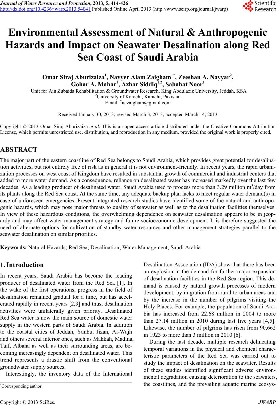
|