Journal of Water Resource and Protection
Vol. 3 No. 3 (2011) , Article ID: 4157 , 6 pages DOI:10.4236/jwarp.2011.33020
Environmental Impact of Flooding in the Main (Smallwood) Reservoir of the Churchill Falls Power Plant, Labrador, Canada . III. Environmental Impact Zones and Direct and Indirect Changes.
1Retired Professor of Faculty of Engineering and Applied Science,
Memorial University of Newfoundland and Labrador
2Retired Sr. Research Scientist, Natural Resources Canada,
Canadian Forest Service, Corner Brook, Newfoundland & Labrador. Presently Ecologist and Chairperson,
Pigugunnatunik Kaujisatik amma katimattisiji, Torngat Wildlife & Plants Co-management Board, The
Torngat Secretariat, P.O. Box 2050, Station B, Happy Valley-Goose Bay, NL, A0P 1E0,
E-mail: bajzak.denes@yahoo.ca, bar@nl.rogers.com
Development
Received December 10, 2010; revised January 15, 2011; accepted February 11, 2011
Keywords: Reservoirs, Flooding, Boreal, Dykes, De-watered, Vegetation Re-growth, Shore Line
ABSTRACT
The Churchill Falls Hydro Project (called the ‘Upper Churchill Development’) in Labrador [CF(L)Co], was initiated in the late 1960s. At that time, in general, not much attention was paid to the impact of such development on the flooding of vegetation, especially forest stands. Both forested and un-forested terrestrial vegetation types were flooded (244,915 ha creating some 74,075 ha of Islands) in the construction of the Main (Smallwood) Reservoir. The effect of flooding and of the constructions, both above and below the Main Reservoir major dyke system, were the subject of our investigation. This paper, the third in a series, reports on the effect of building the dykes during the early phases of construction with the descriptions of the post flooded conditions below the dykes as related to vegetation. The direct disturbances were excavations, fills, and partial and /or total removal of vegetation cover from fabrication platforms and from gravel and rock extraction sites. No new vegetation cover established in the abandoned quarries and gravel pits. However camp sites and manufacturing platforms were subsequently taken over by Alder growth. The indirect disturbances were the flooding of land areas and the de-watering of sections of the original river and lowering of the water level in some lakes. The results of flooding and the de-watering of some nearby areas are illustrated with aerial photographs and figures showing the environmental impact zones and new shore line development. The flooded trees in large and small pools of stagnant water died suddenly and remain in their original place. New vegetation cover developed on the exposed shore lines of de-watered rivers and lakes.
1. Introduction
During the establishment of the hydro-electric powerplant at Churchill Falls several studies, concerning the effect of flooding on the environment, were supported by the Churchill Falls (Labrador) Corporation, [CF(L)Co]. Two of these studies were conducted by the authors. It was hypothesized that the most imminent changes would take place during the first few years of flooding and the less visible changes would occur slowly, therefore, field observations were carried out yearly from 1972 to 1975, then five and 10 years intervals. The first longer term (five years) observations were conducted in 1977. Field work of the 10 years periods was not fully supported, therefore, only cursory observations of the previously established test areas were carried out in 1985, 1989, 1996, and in 2006 in connection with other projects. Some aspects on the effect of flooding above the dykes have been reported [Bajzak and Roberts 1,2], but little has been published on the effects of flooding on Boreal vegetation. In this paper we pay particular attention to changes that took place below the dykes of the Main Reservoir during the first five year period after the flooding. Elements of the development (reservoirs, dykes, and control structures) were described earlier and the established ‘environmental impact zones’ are now presented in Figure 1. This figure should be used by the reader to locate various structures and areas referred to in the text. The changes in vegetation cover below the dykes due to the construction activities were investigated. In addition to our work an intensive biological program was conducted by biologists of Memorial University of Newfoundland which was concentrated around the spray zone of the original falls indicating that the original spray zone (1 cm/hour precipitation) covered an area of about 300 m radius in semi-circle [3,4]. The Boreal vegetation here is tundra like meadows dominated with wet mosses (Sphagnum limbergii and Paludell squarrosa). In some open areas the ground was covered by dense crust of leafy liverworth (Anthelia julacea). Some other areas have an over storey of fairly dense coniferous forest with some scrub Alder [4].
2. Methods
The field investigations concentrated along the ‘Sandgirth-Lobstick’ dykes because of easy accessibility of this area by motor vehicle as we had time limitation on our field work. The changes around the Orma and Sail dykes are considered similar to those of the Sandgirth-Lobstick dyke system (Figure 1). In addition observations and oblique aerial photos taken from helicopter during regular dyke surveys, enabled investigations to be made on the whole perimeter of the flooded reservoir. Interpretations on small scale, color infrared vertical aerial photographs were conducted on various sections of the reservoir. Detailed descriptions were carried out in three defined areas (gravel pits & quarries, flooded areas below the dykes and the test lake). This material was then evaluated and interpreted and the descriptive results pre-
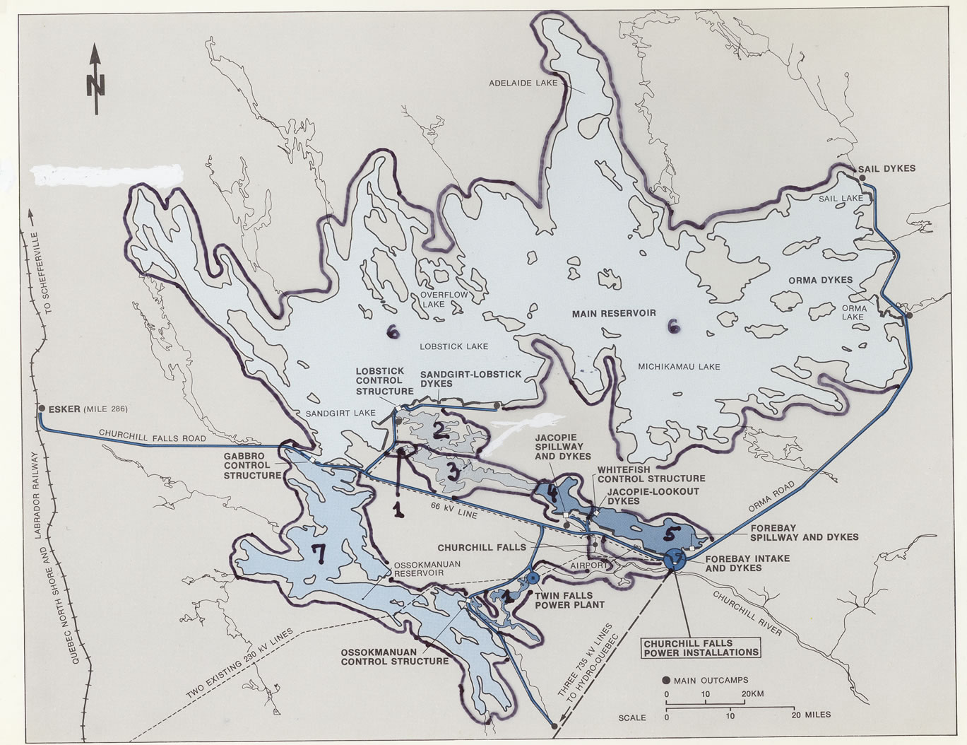
Figure 1. Location of Major Structures and Environmental Impact Zone.
LEGEND:Zone boundary: Thick line Code #:1: De-watered sections of the original rivers. 2: Original river with sustained increased flow. 3: Relatively unchanged rivers. 4: New reservoir, flooded river valleys with fluctuating water levels in ice-free months. 5: New reservoir with substantially raised water level of many lakes, nearly constant water level during the summer months. 6: Main Reservoir, flooded flat plateau with many lakes of substantially raised water level which fluctuates on an annual cycle. 7: Older reservoir (Ossokmanuan) similar to 6 above.
sented with the support of drawings and photographs. To study the long term changes in tree survival and growth pattern ten 1/100 ha sample plots were established in critical areas in 1989. Every tree was marked with a numbered tag, species recorded, diameter at breast height (d.b.h.) measured, and the height of selected trees was determined on each plot.
3. Results and Discussion
3.1. Direct Disturbances (Quarries, Gravel Pits,
Boulder Fields and Fabrication Sites)
The building of the dykes and of access roads required many excavations and the movement of large amount of rock and gravel. Numerous rock quarries and gravel pits were established near the dykes and many boulders were removed from nearby boulder fields. Most of these areas were abandoned after the construction without any preparation for re-establishment of vegetation. However, many of the gravel pits were reserved for re-activation if needed. Due to the continuous water movement in the excavations, structured soil was not evident, only silt accumulated in the bottom of the pits on which pioneer vegetation could be established. The walls of the pits are steep and considerable erosion of soil occurs at their rim causing the up-rooting of trees. The cleared up boulder fields have very little soil so they do not support tree growth at this stage.
During the construction period camps and fabrication sites were established, causing the total removal of vegetation from large areas. These sites were also abandoned without any preparation for tree establishment. After considerable time (approximately 40 years), these areas were taken over by thick Alder (Alnus crispa (Ait.) Pursh) growth. Some semi-permanent structures left behind are in a deteriorated state. The building of roads and digging of ditches caused significant disturbances of nearby areas. Some of the roads were permanently flooded but road sides on drier areas were reoccupied quickly by lower plants and trees including larch (Larix laricina, K. Koch) stands [5]. The down stream sides of many dykes were seeded thus providing food for the nearby nesting Canada goose (Banta canadensis, Lin.) population.
3.2. Indirect Disturbances (Flooding, Lowering of Water Level, Changes in the Spray Zone)
The construction of dykes resulted in significant alterations of the natural drainage system below the dykes. Large pools were created in some places where the standing trees died suddenly (Figure 2). Artificial channeling of a few lakes to remove seeping water from the nearby dykes caused considerable drop of water level there. Large areas were dried up and new shore lines were established. Since this type of change can occur during the construction of other reservoirs, we established a long term research project in one of the lakes where we carried out very detailed field observations. In places where the near shore lake bottom was gently sloping mud flats were developed, while steep sloped areas contained very large boulders. In our test lake the water level was lowered by approximately 1 m (3 feet) exposing a 10 to 80 m (30 to 300 feet) wide strips of periodically dried-up land (Figure 3). The type of newly established vegetation communities on these areas, identified by capital letters on Figure 3, was determined by the underlying soil material and by periodic water level fluctuation.
Near the original shore line a dense mixture of Alder and Willow (Salix pirifolia Anderss) thickets can be found (area at letter A ). Between this area and the water, muddy surfaces exist (at B). On the higher-drier parts various moss colonies (Polytrichum and Bryum species) established soon after the de-watering. There is a continuous struggle existing here between the new vegetation cover and surface erosion. The area identified by letter C is composed of water-logged silt deposits covered by a thick layer of sedges (Carex aquatilis, Carex saxatilis and Eriophorum opacum,) bordered by willows. The area at D is a narrow strip of large boulders with some Alder bushes growing in the hollows between the boulders. The shores of muddy materials (at E) are sparsely vegetated but later succeeded by Alder bush growth. The area at letter F is a very large gentle sloping mud flat composed of impermeable silty-clay and does not support any vegetation growth. Where the shore is steep (at G) a narrow area of large boulders is present,
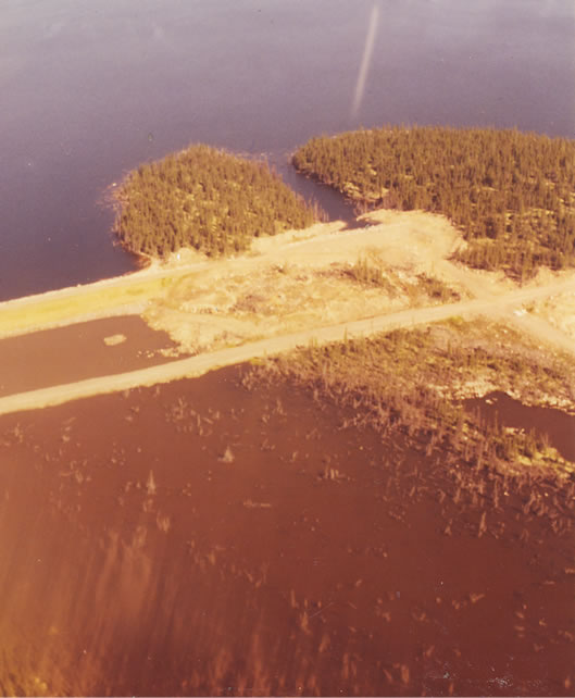
Figure 2. Flooded Pools (with flooded water killed trees).

Figure 3. Test Lake.
bare of any herbaceous vegetation (here no soil can be found between boulders). Between the road side and bolder shore, thick alder growth developed and increased in size to 3 meters by 2006. When we revisited the site during the summer of 2006 our test lake was completely filled with water to the ‘Alder’ shore line for the very first time in our observations. The lowering of the water in this type of lake significantly improved the habitat of waterfowl by providing easily accessible food and nesting places.
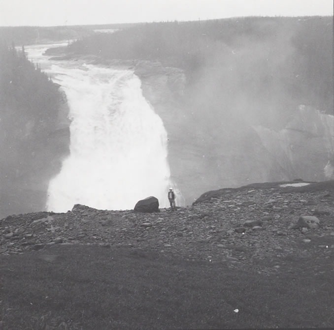
The ‘birds eye view’ of changes in the environment above and below the dykes is illustrated by Figure 4, (see also Figure 1). Figure 4 also shows the location of the test lake (arrow), its surroundings and the major dewatered rivers{ ( #1) and Zone 1 in Figure 1}. The original spray zone [3,4]) contains wooded areas with several Boreal tree species (see Figure 5 for falls and spray area). This figure illustrates the falls in 1969 (a), and in 2006 (b). The falls was originally named Hamilton Falls but was renamed Churchill Falls in connection with the development. Originally this largest river in Labrador was referred to as the Grand River with the Innu name Mishta-Shipu.
4. Summary, Conclusions and Future Work
Creation of large reservoirs for the generation of hydro-electric power always affects the environment locally and downstream. It is important, in connection with these developments, to evaluate the short and long term changes caused by the flooding. The development at Churchill Falls, Labrador, Canada presented an opportunity to investigate the effect of flooding in the Boreal northern temperate region. The papers I, II and III report on the results of short and long term research starting with the establishment of the Main Reservoir (Bajzak and Roberts [1,2]). Background information and the study of the natural re-establishment of vegetation in the vicinity of the main dyke system was a main goal of the research. The most visible changes occurred during the

Figure 4. De-watered and surrounding Area. {This figure is a section of a high altitude (small scale) color infrared vertical aerial photograph taken after the dyke system was completed in 1972}.
 (a)
(a) (b)
(b)
Figure 5. Churchill Falls then and now. a) Original Falls in 1969 b) Dewartered Falls in 2006).
first five year interval of flooding. The long term effect of the flooding needs to be monitored at 10 year intervals while the reservoir and the power plant is in operation. The short term changes near to the rim of the reservoir just above the dykes were already reported [2], but this paper deals with the evaluation of the effects concerning the building and maintenance of the dykes. Numerous gravel pits and rock quarries were established, and in some places the drainage system of areas below the dykes was changed drastically. Few areas supporting forests were flooded below the dykes. The water of some lakes was lowered to provide adequate drainage of water seeping through the dykes.
Since our work was fully supported only for several years we report in this paper the changes which took place during the period of 1972 to 1977. However, we had the opportunity, within the frame work of other projects, to revisit our test areas approximately at ten year intervals (in 1985, 1996, and in 2006) to make cursory observations. We referred to some of these in this paper. Since the ‘spray zone’ of the original falls is a significant feature and this area includes balsam fir (Abies balsamea Mill.), white spruce (Picea glauca Moench Voss) and black spruce (Picea mariana B.S.P.) trees, we have much interest in the growth pattern of these trees as affected by the introduced environmental change (elimination of the falls and the spray zone and ice loading). This will be a focus of such longer term studies. The planned future work in 2011 will evaluate the changes in growth parameters of trees and vegetation cover in the fall’s spray zone. In addition the 40 years changes as exhibited by the previously established test areas will also be investigated.
Currently there are plans to develop the so called ‘Lower Churchill’ area by establishing new power plants at Gull Island and at Muskrat Falls (as announced by the NL government in November 2010) with associated reservoirs. These new plants would use the discharged water of the plant at Churchill Falls and the additional water from some of the Churchill River Basin. The information provided by our published papers could have special relevance to the environmental evaluation of these new developments.
5. Acknowledgement
This research program was supported by the Churchill Falls (Labrador) Corporation in the past on contract to Memorial University. In particularly we would like to acknowledge Dr. A. A. Bruneau’s contribution to the project and the preparation of the earlier reports. The authors would like to express their thanks to the Canada Centre of Remote Sensing for providing the small scale remote sensing imagery. We thank the staff of the Water Resources Division of CF(L)Co for some of the field logistics and in kind support. We also thank Natural Resources Canada, Canadian Forest Service and the Forest Ecology Centre, Provincial Department of Natural Resources for field, lab and storage facilities over a long period of time. Thanks are also due to the Faculty of Engineering and Applied Science, Memorial University for in-kind support after the research work was completed while one of the authors was employed by the University. We also thank Wayne T. Kelly, RPF, Director and William M. Clarke, RPF, Ecologist, Center for Forest Science and Innovation Forestry Branch Department of Natural Resources for additional logistics and publication support.
REFERENCES
- D. Bajzak and B. A. Roberts, “Environmental Impact of Flooding in the Main (Smallwood) Reservoir of the Churchill Falls Power Plant, Labrador, Canada. I. Background and Descriptions of Flooded Conditions Related to Vegetation and Land Cover Types,” Journal of Water Resources and Protection, Vol. 3, No. 3, 2011.
- D. Bajzak and B. A. Roberts, “Environmental Impact of Flooding in the Main (Smallwood) Reservoir of the Churchill Falls Power Plant, Labrador, Canada. II. Chemical and Mechanical Analysis of Flooded Trees and Shoreline Changes,” Journal of Water Resources and Protection, Vol. 3, No. 3, 2011.
- G. R. Brassard, S. Frost, M. Laird, O. A. Olsen and D. H. Steele, “Studies of the Spray Zone of Churchill Falls, Labrador,” The Biological Conservation, Applied Science, Publishers Ltd., England, 1971, pp.13-18.
- G. R. Brassard, “Mosses Associated with Waterfalls in Central Labrador, Canada,” The Biologist, 1972, Vol. 75, pp. 516-536.
- B. A. Roberts and R. S. van Nostrand, “Distribution and site Ecology of Eastern Larch in Newfoundland, Canada,” In: W. C. Schmidt and K. J. McDonald, Eds., Ecology and Management of Larix Forests: A Look Ahead, USDA, Forest Service Intermountain Research Station, General Technical Report GTR-INT-319, 1995. pp. 349-357.