Advances in Remote Sensing
Vol.3 No.1(2014), Article ID:43421,10 pages DOI:10.4236/ars.2014.31003
Study of Some Lakes in the North-Eastern Romanian Plain Using the Coherence Image of the Tandem Pair (ERS-1 and ERS-2)
Kamel Hachemi1,2, Marta Jurchescu3, Florina Grecu4, André Ozer5, Mircea Cristian Visan4
1LGP (Physical Geography Laboratory), UMR 8591, CNRS-National Centre for Scientific Research, Meudon, France
2University of Paris-Est and University Paris 1 Panthéon-Sorbonne, Paris, France
3Physical Geography Department, Institute of Geography, Bucharest, Romania
4Geomorphology-Pedology-Geomatics Department, Faculty of Geography, University of Bucharest, Bucharest, Romania
5Geomorphology and Remote Sensing. Geography Institute, Liege University, Liège, Belgium
Email: hachemi_kamel@yahoo.fr, kamel.hachemi@u-pec.fr, marta_jurchescu@yahoo.com, grecu@geo.unibuc.ro, florinagrecu@yahoo.com, visanmirceacristian@gmail.com, aozer@ulg.ac.be
Copyright © 2014 by authors and Scientific Research Publishing Inc.
This work is licensed under the Creative Commons Attribution International License (CC BY).
http://creativecommons.org/licenses/by/4.0/


Received 15 December 2013; revised 15 January 2014; accepted 22 January 2014
ABSTRACT
In radar SAR interferometry (InSAR/DinSAR), a Tandem pair (ERS-1/2) is used for the realization of a DEM or the detection of deformations of a major event (e.g. earthquake) occurring between two acquisitions. The advantage of the Tandem pair is the time interval of 24 hours between the two captures. Generally, there is no temporal decorrelation considering the small difference in time between the acquisitions, which results in a good coherence. The coherence image is used indirectly in radar SAR interferometry as an indicator of the levels of confidence of the interferograms. It can be used in a direct way to identify and delimit the various movement zones which disturb the phase of the radar wave. The objective of this work is to show the utility and the effectiveness of the coherence image in the cartography of lakes and vegetation in a region at the Curvature of the Romanian Carpathians1. Between the two acquisitions dates of May 28 and 29, 1995, there was no geological process involving displacements in direction of the radar. This pair represents the only one among the other pairs which gave a good coherence for the whole scene. In the flat part, one notes a good coherence except for the lakes. They are well represented by very dark colours with zero coherence. In the part of high altitude, especially where there is vegetation, a bad coherence can be clearly seen. Using this image (coherence), one could distinguish the parts with vegetation in great movements due to the effects of the wind, therefore characterised by great heights. The coherence image thus makes it possible to delimit two natural elements in this area, the lakes and the vegetation. The lakes are well delimited, in particular when they are full as in the rain seasons. To show this utility and this effectiveness of the coherence image, we measured the surfaces and dimensions of the lakes based on the Tandem pair and to make a comparison with the existing data and to interpret the results obtained. The three lakes, located in the plain to the East and North-East of the Buzău town, clearly appear in the coherence image.
Keywords:Coherence; Buzău; Lakes; Radar; SAR; Tandem Pair; ERS-1; ERS-2

1. Introduction
The indirect applications of radar SAR interferometry consist in using other products than the interferograms, like the coherence images. Generally, the coherence image is used indirectly in radar SAR interferometry as indicator of the levels of confidence of the produced interferograms in order to exploit these. It can be used in a direct and precise way to identify and delimit the various movement zones which disturb the phase of the radar wave. This delimitation is based on the fact that coherence depends on the parameter of the phase in each pixel. This parameter reacts in several cases as indicator of the unstable surface movements. These movements like the swells of water surface disturb the phase. In this case, coherence is null and it is represented by a dark colour. On the other hand, the stable places like the urban one, preserve the phase and are represented in light. However, this parameter serves as an indicator and at the same time a separator between the movement zones and the stable ones. The coherence images of the Tandem pair have been used in a remarkable and effective way in several fields and to various objectives. They are important to many applications, such as geodynamics, agriculture, ice and soil moisture monitoring. In the extraction of parameters for forest by means of interferometry, combinations of data on retrodiffusion coefficient and coherence with a DTM, could estimate the concrete size of forest trees [1] and [2] . In the studies of biophysic characteristics of forest sectors, the combination of pair coherence images and amplitude images (retrodiffusion coefficient) from JERS satellite has significantly brought information on the evaluation of biomass density and land cover in tropical forests [3] . In the case of floods, the integration of amplitude and coherence images has been used to indicate all the sectors flooded between two passages of the satellites, which made it possible to establish a precise flood map for the area of Béziers (Southern France) [4] . The coherence images of the Tandem pairs ERS-1/2 (24 h) have the potential to be used for the assessment of the trees volume in the northern forests and proved to be better than optical data (SPOT XS) in certain cases [5] . Among the six coherence images used, three Tandem pairs’ effectiveness was proven in differentiating between certain classes of surfaces, which were not distinguished by the radar amplitude (retrodiffusion) images. They were used to distinguish places covered by willow tree-alder, fir tree, ice and water in the Mackenzie delta (Canada). Surfaces with willow-alder showed the highest rate of coherence followed by those covered by fir tree, frozen lakes, frozen and water channels respectively [6] . A certain category of coherence can be correlated with a certain type of land cover to provide information on time changes between the two aquisitions of SAR images, as in the case of urban application, where they are used in the monitoring of the cities. The coherence image can provide useful information in detecting expansion activities. Coherence in urbanized lands is higher than in those with vegetation cover. The change of the rates of coherence from lower values to higher ones in certain places can give an indication on the replacement of the vegetation by buildings [7] . In the mapping of the Antarctic’s limits, the use of coherence was advantageous and concluded that the technique of interferometry using RADARSAT images provides very satisfactory results for the Antarctic’s cartography in comparison with the optical images (LANDSAT and SPOT) [8] . In large scales mapping, the coherence images of Tandem pairs (ERS) were also used and associated with JERS amplitude images (coefficient of retrodiffusion) for the monitoring of the evaluation of the northern forest in SIBERIA [9] . In the field of agriculture, the coherence images of the Tandem pairs (six pairs) were used for the research of harvest parameters (size, moisture, etc.). They showed their utility and effectiveness in the monitoring of harvest of fields with winter wheat, sugar beet, potato and corn [10] . In the cartography of earthquake-related damages, the variations of coherence images were used to map the damages caused by the seism of Bam (December 26, 2003) [11] . There is also the cartography of a forest’s age by using the coherence of the ERS Tandem pair. This mapping showed a spatial resolution which could differentiate between various forest groups and provided detailed regional age and biomass assessment in regions of England, Scotland and Wales. This distribution and comparison between the evaluations by age and other information had the capacity and the potential to provide growth rate and information on forest cutting in these areas [12] . In the studies on forest-fire hazards, the images of multi-pass coherence of various bands (X, C and L) were used for assessing the severity of burned areas in the Mediterranean forests. In these places of fire-affected pine trees, the coherence image was very useful to map the severity of burning in these Mediterranean environments [13] .
In this work, we will try to calculate the dimensions of the lakes based on the coherence image of the ERS1/ERS2 Tandem pair for a region at the Curvature of the Romanian Carpathians, check the precision through ground measurements, make a comparison with existing data and interpret the obtained results.
2. Coherence and Incoherence Origin
2.1. Coherence Image (Coh)
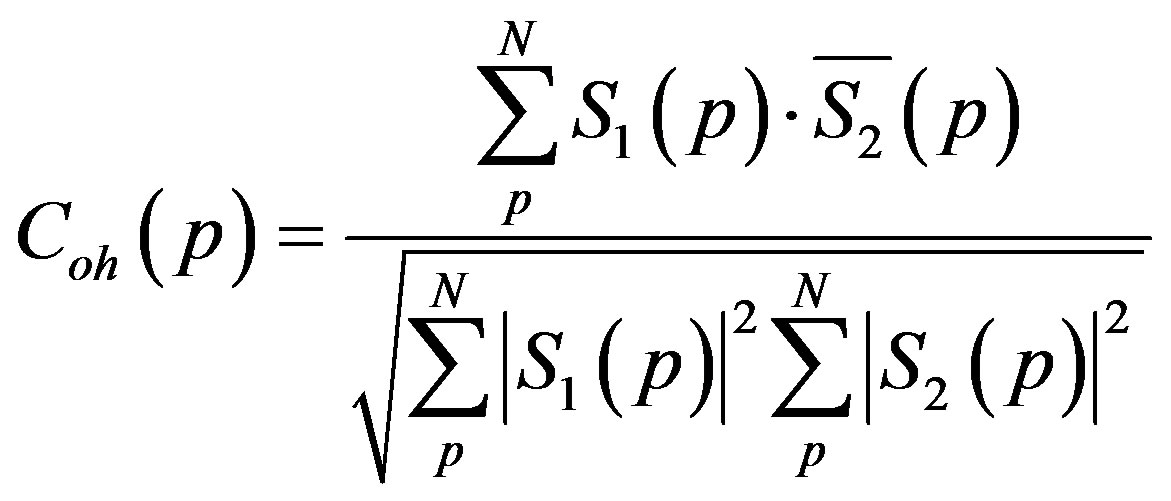
Theoretically coherence is defined by the coefficient of correlation ( ) between the two acquisitions of the two images which build the interferogram [14] . It is a mathematical comparison between the created interferogram and the product of the two modules of the two images for each pixel of the coloured scene, with a resampling to a new pixel size. The following formula makes it possible to evaluate the degree of confidence of the interferogram.
 (1)
(1)
Whit:
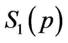 : Complex Master radar image for the pixel (p);
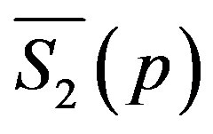 : Combined complex Slave radar image for the pixel (p);
 : Modules of the complex Master image for the pixel (p);
 : Modules of the complex Slave image for the pixel (p);
N: Number of pixels in the sampling zone.
In practice the coherence image makes it possible to give an outline of the variations which can exist between the two images used, i.e. on the retiming of the two images or the geometrical conditions of the acquisition of these two images, as well as on the probable changes of the physical characteristics of the coloured target between these two captures, for all the sampling zones.  is a correlation coefficient (degree of coherence) translated by values ranging between [0 and 1]; the degree (1) represents a strong coherence between these two images, while the degree (0) means a null coherence. Coherence is thus an estimate of the degree of stability of the phase between the two radar images acquired under the almost identical geometrical conditions of the same scene. This stability and instability are represented in the coherence image, in case of a bad coherence, by dark zones and for good coherences by clear zones. In a grey scale, the degree of coherence varies from black (minimal value) to light (maximum value).
2.2. Origins of the incoherence
The reliability of the interferogram created by SAR interferometry (InSAR) consists in the coherence image; a maximum degree means strong correlation between the two phases and is interpreted on the ground as no change between the two dates of acquisition of the images having identical or almost identical geometrical conditions of capture and the same level of static distribution of speckle [15] . On the contrary, a minimum degree of coherence means that on the ground the two pixels of the two images underwent a change or the two pixels quite simply do not have the same position. Weak coherence between two acquisitions can have several origins: important difference in the angle of incidence between the two acquisitions especially for the slopes directed towards the radar sensor; change of the soil physical characteristics between the two acquisitions; surfaces in continual movement like those of lakes, seas etc; zones covered by vegetation especially forests because of the fast accumulation of movements under the effect of winds; any movement on the ground can affect the phase between two acquisitions (passage of vehicle, ploughings etc).
3. Study Area, Lakes and Data Used
3.1. Localization and Characteristics of the Study Area
The study area extends over parts of the outer Curvature Carpathians, Curvature Subcarpathians and North-Eastern Romanian Plain (See Figure 1). This situation is the seat of frequent phenomena like earthquakes, floods, landslides and mud flows. The Buzău valley is also known for the presence of mud volcanos (along an anticline depression) which is due to the eruption of gas from oil-bearing layers at a depth from 200 to 300 m. This study area is delimited by the following geographical coordinates: 44.813˚/45.926˚N latitude to the south and north respectively; 26.089˚/27.614˚E longitude to the west and the east respectively. This study area is also characterized by: (1) a flat low-lying area, which is represented by the North-Eastern Romanian Plain located in the east with average altitudes between 30 and 80 m; (2) a mid-to-high altitude area represented by parts of the Subcarpathians and Carapathians in the west, and characterized by: (I) an intermediate part with altitudes ranging from 300 to 400 m; and (II) a high part with altitudes above 1000 m [16] . The three relief steps characterising the ground of the study area can have various answers of the radar signal retrodiffused towards the sensor: (1) a flat ground corresponding to the North-Eastern Romanian Plain in the east; (2) an intermediate area with slopes directed towards the radar; (3) an area of high altitude and dissected terrain extending from the high Subcarpathian hills to the Carpathian relief in the west.
3.2. Studied Lakes
In this area, there are also four lakes which are visible on the radar image. Three are very large and are located in the east: Balta Jirlăul, Balta Amara and Balta Alba (in their order from south to north). The fourth, which is small, is called the Luciu lake and is located in the south, close to the Bărăgan Plain. The first three lakes are situated north-east of Buzău town and appear clearly on the radar image. They are located in the plain; the near est lake to the Buzău city (aprox. 31 km away) with a length of 5.38 km and width of approximately 2.28 km, is
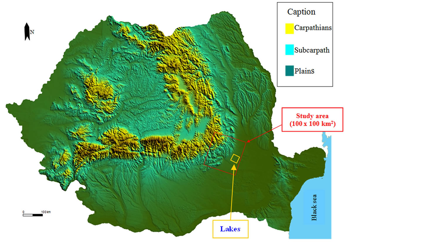
Figure 1. Map of Romania. The study area is indicated.
Balta Jirlăul. The second one, in the terms of the distance from the Buzău town (approx. 38 km) is Balta Amara and has a diameter of approximately 3.27 km. The third lake is Balta Albă (43 km distance from the Buzău town) and has a 6 km length and a width of 2.5 km approximately (See Table 1). These lakes are located at the contact between the piedmont-type plain and the subsidence area of the Călmăţui-Buzău and Lower Siret rivers. In fact, the lakes are formed on rivers which are tributary of a larger river, more precisely they are formed at the point of confluence of the tributaries with the main river (Buzău river). The Buzău river has tributary rivers which have their sources in the piedmont-type plain, and have lengths of 15 to 30 km. These lakes have a double water input: they are fed by the main river, i.e. Buzău river, and by the tribuary streams having their sources in the piedmont-type plain. In the area of confluence, the outlet of the tributary is sealed by alluvia which lead to water accumulating behind and transforming into big lakes (“balta” is the local term).
They are salted natural lakes, with a salinity degree which varies according to the climate. In the event of dryness, they are very salted. On the other hand, during abundant precipitations, they are less salted because of the strong Buzău river discharge and of rainwater. They were formed at the end of the Upper Pleistocene and beginning of the Holocene.
Balta Jirlăul, is a fresh water lake. Balta Amara and Balta Albă, have a high mineralisation and a great salinity.
The Figure 2 shows heights, depressions corresponding to the Curvature Subcarpathian and Carpathian units, the North-Eastern Romanian Plain and the river courses. On this figure the limits between the various relief steps can be easily drawn. The rivers emerge towards the south and south-east in the Buzău and Râmnicu-Sărat rivers. The study area shows two great collectors for the rivers which come from this part of the Carpathians and Subcarpathians: the rivers of Buzău and Râmnicu-Sărat, well represented on the radar amplitude image (See also Figure 2). These two rivers are the independent water supply sources for the three big lakes in the plain (Balta Jirlăul, Balta Amara and Balta Albă).
3.3. Data used
The data used are SAR data, of the SLC (Single Look Complex) type, from the satellites: ERS-1, ERS-2 and

Table 1. Geometrical characteristics of the capture and rates of coherences of the pair images (ERS-1/ERS-2).
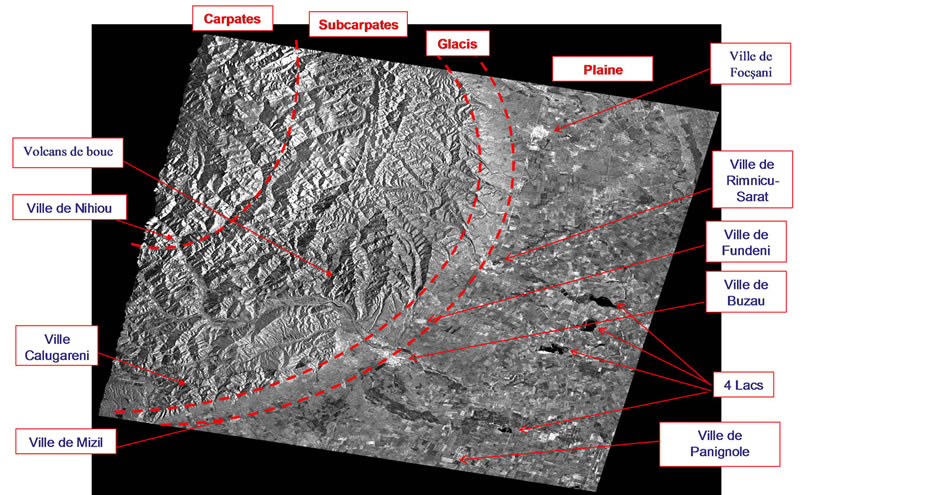
Figure 2. Georeferenced radar amplitude image of the study area.
ENVISAT. These used SLC data were processed by pulse compression in radial direction (in distance) and by aperture synthesis (SAR) in azimuth direction in the framework of the same Processing and Archiving Facility (UK-PAF). The acquisition of the images is downward (acquisition of day) with V/V polarization and “C” band of 5.56 cm wavelength.
For this study, we used 8 SLC radar SAR images:
4 ERS images: an image of the satellite ERS-1 and three images of the satellite ERS-2, of which 1 tandem pair (ERS-1 and ERS-2). The dates of acquisition of these ERS images are: May 28 and 29, 1995, June 17, 1996 and November 29, 1999 respectively;
4 ENVISAT images: two of 2004 (October and December) and two of 2005 (January and April). These images cover a surface of (100 km × 100 km) with an azimuth resolution of 4m and 20m range resolution. These images were obtained from the ESA by the Laboratory of Geomorphology and Remote Sensing, University of Liege, within the framework of a research program shared between the universities of Liege (Belgium), Paris-XII (France) and Bucharest (Romania). The two images taken on May 28 and 29, 1995 respectively form a tandem pair ERS-1/ERS-2.
4. Methodology and Results
In this study, using the InSAR radar interferometry technique, we generated a coherence image of the tandem pair of 20 m resolution. We also georeferenced this coherence image. The result obtained is a georeferenced coherence image of the tandem pair (May 28/29, 1995) with a 20 m resolution (see Figure 3). In the effort to conduct this study well, we also calculated the rates of coherence of the tandem pair treated by InSAR. We divided the coherence image of the entire scene into two parts according to the characteristics of this study area: a plain area which is flat and a part of relatively high and rough relief. We calculated the rates of coherence of the whole scene, then the two parts separately (a flat low-altitude and a high-altitude one). The result is presented in Table 1. This table presents characteristics of the geometry of capture as well as the calculated rates of coherence of the tandem pair (ERS-1/ERS-2).
Delimitation of the lakes based on the coherence image To show the utility and the effectiveness of the coherence image we measured the area and dimensions of the lakes based on the tandem pair (see Table 2).
To the north-east of the Buzău town, there are three lakes which appear clearly in the coherence image and which are located in the plain. Table 2 shows areas and dimensions of these lakes measured starting from the coherence image of the pair dated May 28 and 29, 1995.
5. Discussions and Interpretation
The tandem pair (May 28/29, 1995) represents the only one among the other pairs which gave a good coherence for the entire scene. This coherence testifies to the reliability of the interferogram resulting from these two dates. For this tandem pair (ERS-1 and ERS-2), the time interval between the two acquisitions is of 24 hours, which resulted in a good coherence. This couple was also used in other works for the creation of a DEM [17] . There is no temporal decorrelation considering the small difference in time between the captures of two SAR images.
After having calculated the rates of coherence for the whole scene and separately for the two parts (one of mid-to-high altitude and one flat low-lying), we calculated dimensions of the lakes and the vegetation in the study area. The coherence image for the study area obtained using the images of the tandem pair (ERS-1 and ERS-2), gives a bad coherence for the parts with vegetation and lakes and a good coherence for the urban areas. These results are explained as follows: (I) the lakes are covered with a surface water layer in continual change (as an effect of the wind on the surface), explaining the weak coherence between the images; (II) the mid-to-high terrain parts appear in black; they are covered with high vegetation (wood, forests) which can present different aspects from one image to the other (effects of the wind for example), explaining the weak coherence between the images; (III) finally the plain area, probably with little vegetation (or dry grounds) at the time of the images’ acquisition, is affected by little change, which determines strong coherence between the images; (IV) the urban areas, due to their stability, are represented by good and strong coherence. Between these two dates of capture (May 28 and 29, 1995), there was no geological process involving changes higher than 28 mm (1/2 wavelength of the “C” band) in direction of the radar. In the plain part, one easily sees a good coherence, but in the part of mid-to-high altitudes, especially where there is vegetation, one clearly sees a bad coherence.
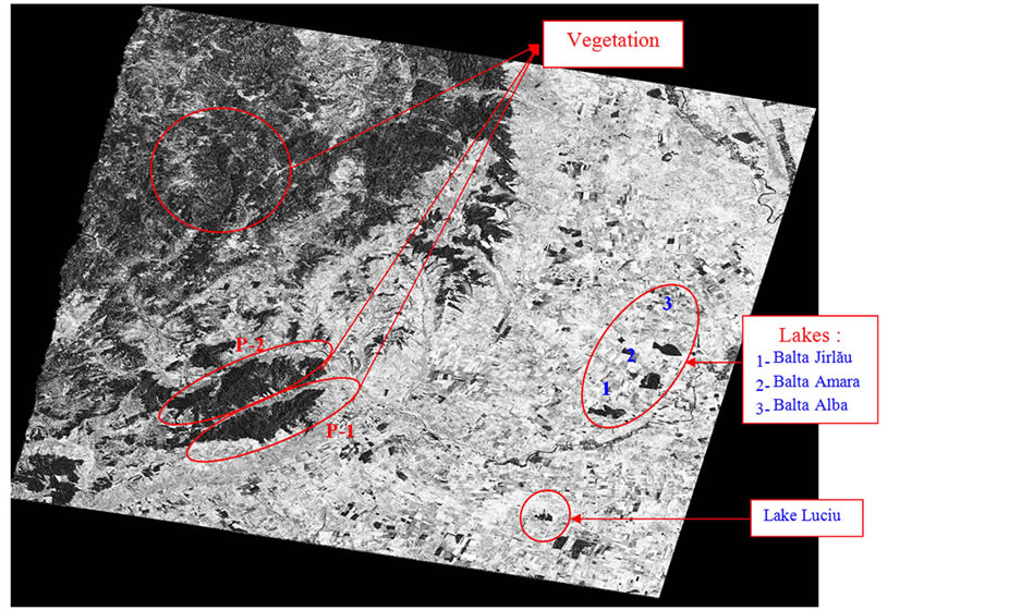
Figure 3. Georeferenced coherence image of the tandem pair (May 28/29, 1995). The lakes are numbered in the order of their distance from the Buzău town.
Table 2. Delimitation of the lakes based on the coherence image.
Using this coherence image those parts could be delimited where the lakes characterised by wind-induced movement are. The lakes are well delimited and especially when they are full as in the rainy seasons (See Figure 4) and they are well presented in very dark colours with a null coherence. This pair (coherence image) enabled us to calculate, with a high degree of accuracy, dimensions of the lakes’ surfaces in the research area. On the other hand, the precision of this measurement is in the order of one pixel (20 m × 20 m), i.e. ± 0.0004 km2.
Then, we compared these results with the only existing data, of 1963 [18] . The areas of the three lakes in 1963 are as follows: Balta Jirlăul = 10.69 km2, Balta Amara = 6.98 km2 and Balta Albă = 10.68 km2. The comparison between these data (1963 and 1995) on a 32 years interval allows the affirmation that two lakes, Balta Albă and Balta Jirlăul, are in regression and other one, Balta Amara shows an extension. The difference between the two measurements (1963 and 1995) is summarized in the following Table 3. It shows also the speed of this variation of surface water during this period of 32 years.
During one 32-year-period, we note a reduction in the areas of the two lakes Balta Albă (to the north) and Balta Jirlăul (to the south). On the other hand, the lake situated between the two (Balta Amara) increases in surface. That lets us assume that the first two lakes feed the central lake corresponding to their water surface reduction estimated at 2.2786 km2 during these 32 years.
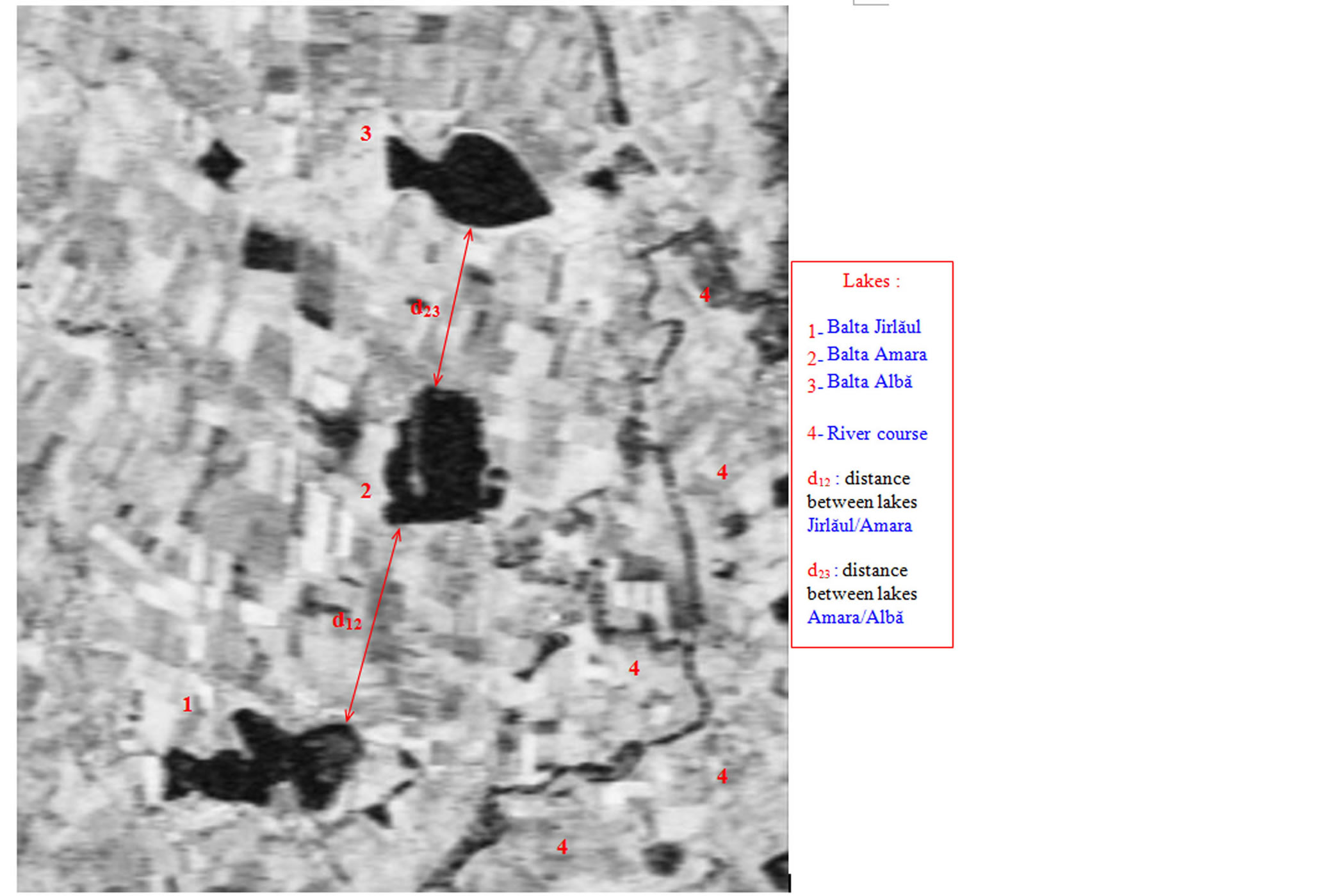
Figure 4. Area of the lakes on the coherence image (tandem pair, May 28/29, 1995). The lakes are numbered in the order of their closeness to the Buzău town.
Table 3. Comparison between the two area measurements (1963 and 1995) of the three lakes.
The three lakes are located in the subsidence and divagation plain. This plain is located between the rivers of Buzău and Călmăţui; it occupies a very low area which corresponds to Holocene alluvial accumulation. The altitude of this area lies between 82 m (in the southern proximity of the Buzău town) in the west and 51 m in the east. These lakes are located at the contact between the piedmont-type plain and the subsidence area of Călmăţui-Buzău and Lower Siret rivers. In fact, the lakes are formed on rivers which are tributaries of a larger river. They represent the convergence point of streams and the main river, Buzău. The river of Buzău has secondary rivers which have their sources in the piedmont-type plain and lengths of 15 to 30 km. These lakes have a double water supply: they are fed by the main river, Buzău and the secondary rivers with the sources in the piedmont-type plain.
In the places of junction (between the main rivers and its tributaries), the outlet of the river is barred by alluvia which make water accumulate behind forming big lakes (baltă). They are salted natural lakes, with a salinity degree which varies according to the climate. In the event of dryness, they are very salted. On the other hand, during abundant precipitations, they are less salted because of the strong of discharge of the Buzău river and of rainwater. They were formed at the end of Upper Pleistocene and the beginning of the Holocene. Balta Jirlăul, is a fresh water lake. Balta Amara and Balta Alba have high mineralisations and a great salinity.
The alignment between Focşani and Râmnicu-Sărat towns coincides with the area where processes of subduction occurred and where the slow accumulation of seismic energy produced abrupt and violent unloadings corresponding to earthquakes with magnitudes ranging from 5 to 7,4 on the Richter scale and epicentres at depths between 90 and 200 km in the Vrancea Mountains [19] . On the other hand, in the area of the Subcarpathian hills and Carpathian Mountains, uplift movements are of +2 mm/year. The Brasov depression to the north (outside of our study area) is registering subsidence movements of approx. 2 mm/year. The plain part in our study area is characterized by instability due to subsidence which is present in the form of a slow lowering [20] . This movement is characterized by a speed of 2 mm/year in the Buzău Plain which is the site of river divagation. And in the north-east, close to Focşani town, subsidence is relatively active towards the Siret river, the direction the river of Buzău flows to. This movement is of about −2 mm/year. As a proof of this, the Buzău river channel could be mentioned, which changed its course towards north because of this subsidence. The course of the river moved towards north starting from the Deduleşti point. Before 1969, the distance covered by the river’s water was of 16.5 km, which at the same time fed the lake Amara. After this date the river course is cut towards north and travels a distance of 6.5 km towards north (it has creates a new bed-short cut) [21] .
Worth mentioning is also the role of the earthquake of March 4, 1977 of a 7.2 magnitude on the Richter scale which had 4 shocks. Each one of them had a hypocenter of a different depth: 93, 79, 93 and 109 km respectively [22] . The seism which affected this area had the epicentre to the north of the Pătârlagele locality and released an energy equal to 39.8 × 10²¹, which represents 15 times the annual average energy released from the Vrancea Seismic Region [22] [L. CONSTANTINESCU, 1978, cited by D. BĂLTEANU, 1989]. This seism led to the appearance of natural sources, lakes and dams. It also caused mass movements of several types: rock falls, collapses, landslides, mudflows and complex movements. In the Călmăţui-Buzău Plain, the depth of groundwater is between 1 and 2 m. In this subsidence area (Buzău-Călmăţui), the rivers of Buzău and Călmăţui have the same floodplain. During floods, the Buzău river shows waterway divagations or overflow and feeds the Călmăţui river.
This report enables us to suggest the idea that the waters of the three lakes have been converging in only one big lake during this 32-year-period (from 1963 to 1995). This can be supported by the fact that the two lakes to the north and south decrease and the lake situated in the middle increases and can explain the difference in surface (therefore also in water quantity), estimated at −2.2786 km2 for this 32 years duration. One can suggest the idea that the lakes are transforming themselves into only one big lake. We could also estimate the maximum duration of this transformation that does not exceed 1779 years and perhaps could be accelerated by the region’s seismic activity.
6. Conclusions
This study enabled us to confirm the interest of the coherence images of the tandem pair (ERS-1/ERS-2), obtained based on the interferometry technique (InSAR), for the cartography of lakes and vegetation and their monitoring (surfaces characterised by bad coherences). This work shows also the importance of these images and the exploitation of the rate of coherence which lies between [0 and 1] in order to delimit the urban areas from the ones covered by vegetation. The rate of coherence is higher in the urbanized places than in the areas with vegetation and is almost null in the case of seas and oceans.
We could calculate with a high degree of accuracy dimensions and areas of the lakes in a very complex area of the region at the Curvature of the Romanian Carpathians. This study enabled us to advance the theory that the cartography based upon tandem coherence images can compete with measurements on the ground. Coherence in the North-Eastern Romanian Plain is better than in the Subcarpathians and Carpathians. This study also allowed us to suggest that the lakes are in the process of transformation into one large lake, a process which has an estimated maximum duration of 17 centuries.
Acknowledgements
We thank the AUF for the financing for the joint research project on the contribution of multi-resolution satellite imagery in the monitoring of natural risks in Romania, which made it possible to acquire the images used in this work. These images were obtained from the ESA by the Laboratory of Professor André OZER (University of Liege) within the framework of a research program shared between the universities of Liege (Belgium), Paris-XII (France) and Bucharest (Romania).
References
- Askne, J.I.H., Dammert, P.B.G., Fransson, J., Israelsson, H. and Ulander, L.M.H. (1995) Retrieval of Forest Parameters Using Intensity and Repeat Pass Interferometric SAR Information. Symposium International Extraction des Paramètres Bio-Géophysiques à Partir des Données RSO Pour Les Applications Terrestre, Toulouse, 10-13 October 1995, 119-129.
- Askne, J.I.H., Dammert, P.B.G., Ulander, L.M.H. and Smith, G. (1997) C-Band Repeat Pass Interferometric SAR Observations of the Forest. IEEE Transactions on Geoscience and Remote Sensing, 35, 25-35. http://dx.doi.org/10.1109/36.551931
- Luckman, A., Baker, J. and Wegmüller, U. (2000) Repeat-Pass Interferometric Coherence Measurements of Disturbed Tropical Forest from JERS and ERS Satellites. Remote Sensing of Environment, 73, 350-360. http://dx.doi.org/10.1016/S0034-4257(00)00110-3
- Nico, G., Pappalepore, M., Pasquariello, G., Refice, A. and Samarelli, S. (2000) Comparison of SAR Amplitude vs. Coherence Flood Detection Methods—A GIS Application. International Journal of Remote Sensing, 21, 1619-1631. http://dx.doi.org/10.1080/014311600209931
- Fransson, J.E.S., Smith, G., Askne, J. and Olsson, H. (2001) Stem Volume Estimation in Boreal Forests Using ERS-1/2 Coherence and SPOT XS Optical Data. International Journal of Remote Sensing, 22, 2777-2791. http://dx.doi.org/10.1080/01431160010006872
- Hall-Atkinson, C. and Smith, L.C. (2001) Delineation of Delta Ecozones Using Interferometric SAR Phase Coherence Mackenzie River Delta, N.W.T., Canada. Remote Sensing of Environment, 78, 229-238. http://dx.doi.org/10.1016/S0034-4257(01)00221-8
- Stabel, E. and Fischer, P. (2001) Satellite Radar Interferometric Products for the Urban Application Domain. Advances in Environmental Research, 5, 425-433. http://dx.doi.org/10.1016/S1093-0191(01)00094-6
- Gray, A.L., Short, N., Bindschadler, R., Joughin, I., Padman, L., Vornberger, P. and Khananian, A. (2002) RADARSAT Interferometry for Antarctic Grounding-Zone Mapping. Annals of Glaciology, 34, 269-276.
- Wagnera, W., Luckmanb, A., Vietmeiera, J., Tanseyb, K., Balzterc, H., Schmulliusd, C., Davidsone, M., Gaveauc, D., Gluckf, M., Le Toane, T., Quegang, S., Shvidenkof, A., Wiesmannh, A. and Yu, J.J. (2003) Large-Scale Mapping of Boreal Forest in SIBERIA Using ERS Tandem Coherence and JERS Backscatter Data. Remote Sensing of Environment, 85, 125-144. http://dx.doi.org/10.1016/S0034-4257(02)00198-0
- Blaes, X. and Defourny, P. (2003) Retrieving Crop Parameters Based on Tandem ERS 1/2 Interferometric Coherence Images. Remote Sensing of Environment, 88, 374-385. http://dx.doi.org/10.1016/j.rse.2003.08.008
- Hoffmann, J. (2007) Mapping Damage during the Bam (Iran) Earthquake Using Interferometric Coherence. International Journal of Remote Sensing, 28, 1199-1216. http://dx.doi.org/10.1080/01431160600928567
- Drezet, P.M.L. and Quegan, S. (2007) Satellite-Based Radar Mapping of British Forest Age and Net Ecosystem Exchange Using ERS Tandem Coherence. Forest Ecology and Management, 238, 65-80.
- Tanase, M.A., Santoro, M., Wegmüller, U., De La Riva, J. and Pérez-Cabello, F. (2010) Properties of X-, Cand L-Band Repeat-Pass Interferometric SAR Coherence in Mediterranean Pine Forests Affected by Fires. Remote Sensing of Environment, 114, 2182-2194.
- Touzi, R., Lopes, A., Bruniquel, J. and Vachon, P.W. (1999) Coherence Estimation for SAR Imagery. IEEE Transactions on Geoscience & Remote Sensing, 37, 135-149.
- Adragna, F. and Et Nicolas, J.M. (2001) Traitement des images de Radar à Synthèse d’Ouverture (RSO). Sous la Direction de Henri Maître, Hermes Science Europe Publication, Paris, 328.
- Grecu, F., Comănescu, L., Toroimac, G., Dobre, R., Sacrieru, R. and Mărculet, C. (2010) Slope Dynamics-Precipitation Interrelation in the Curvature Subcarpathians (Romania). Revista de Geomorfologie, 12, 45-52.
- Hachemi, K. (2009) Apport de l’Interférométrie Radar SAR Pour la Réalisation d’un MNA (Modèle Numérique d’Altitude) sur la Région Subcarpatique de Buzău (Roumanie). Journal Analele Universitatii Bucuresti, Année LVIII, 5-38.
- Gastescu, P. (1963) Lacurile din Romania. Ed.Academiei, Bucuresti, 293p.
- Geografia Românei, V. (2005) Câmpia Româna, Dunărea, Podişul Dobrogei, Litoralul Românesc al Mării Negre şi Platforma Continentală. Academia Română, Institutul de Geografie, Ed. Academiei, Bucharest, 968p.
- Grecu, F. (2010) Geografia Campiilor Romaniei. Ed.Universitatii, Bucuresti, 260p.
- Visan, G.H., Cirstea, A. and Balauta, L. (1973) Unele Aspecte Climatice in Câmpia Râmnicului. Geografie, Analele Univesităţii Bucureşti, Anul XXII.
NOTES

1In this paper “the Curvature of the Romanian Carpathians” refers to a broader area which includes the Curvature Carpathians and Subcarpathians as well as the outer plain units.