Paper Menu >>
Journal Menu >>
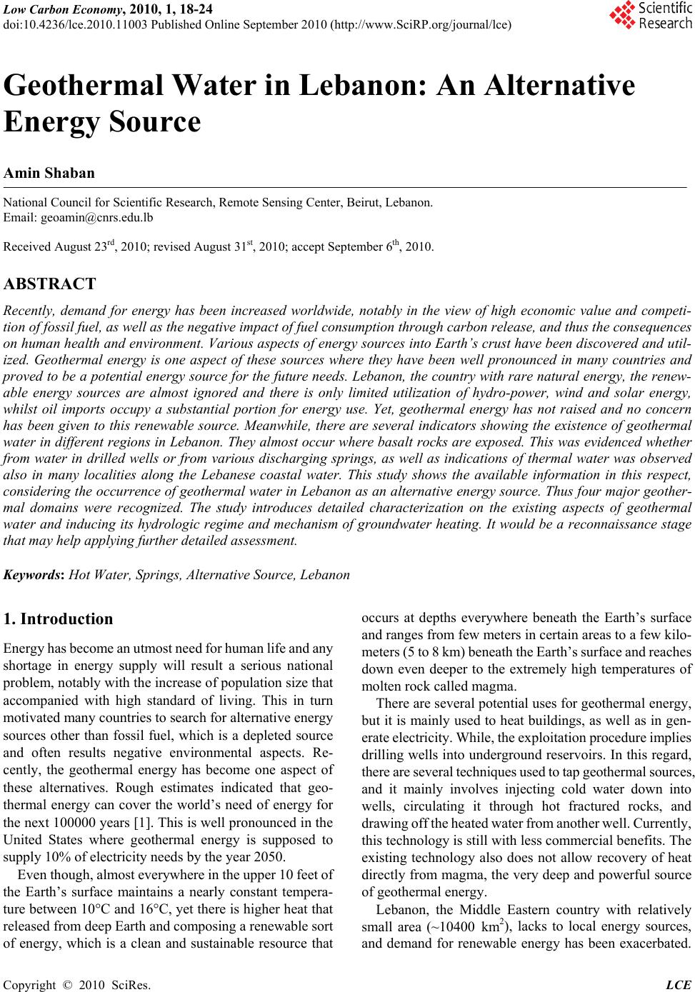 Low Carbon Economy, 2010, 1, 18-24 doi:10.4236/lce.2010.11003 Published Online September 2010 (http://www.SciRP.org/journal/lce) Copyright © 2010 SciRes. LCE 1 Geothermal Water in Lebanon: An Alternative Energy Source Amin Shaban National Council for Scientific Research, Remote Sensing Center, Beirut, Lebanon. Email: geoamin@cnrs.edu.lb Received August 23rd, 2010; revised August 31st, 2010; accept September 6th, 2010. ABSTRACT Recently, demand for energy has been increased worldwide, notably in the view of high economic value and competi- tion of fossil fuel, as well as the negative impact of fuel consumption through carbon release, and thus the consequences on human health and environment. Various aspects of energy sources into Earth’s crust have been discovered and util- ized. Geothermal energy is one aspect of these sources where they have been well pronounced in many countries and proved to be a potential energy source for the future needs. Lebanon, the country with rare natural energy, the renew- able energy sources are almost ignored and there is only limited utilization of hydro-power, wind and solar energy, whilst oil imports occupy a substantial portion for energy use. Yet, geothermal energy has not raised and no concern has been given to this renewable source. Meanwhile, there are several indicators showing the existence of geothermal water in different regions in Lebanon. They almost occur where basalt rocks are exposed. This was evidenced whether from water in drilled wells or from various discharging springs, as well as indications of thermal water was observed also in many localities along the Lebanese coastal water. This study shows the available information in this respect, considering the occurrence of geothermal water in Lebanon as an alternative energy source. Thus four major geother- mal domains were recognized. The study introduces detailed characterization on the existing aspects of geothermal water and inducing its hydrologic regime and mechanism of groundwater heating. It would be a reconnaissance stage that may help applying further detailed assessment. Keywords: Hot Water, Springs, Alternative Source, Lebanon 1. Introduction Energy has become an utmost need for human life and any shortage in energy supply will result a serious national problem, notably with the increase of population size that accompanied with high standard of living. This in turn motivated many countries to search for alternative energy sources other than fossil fuel, which is a depleted source and often results negative environmental aspects. Re- cently, the geothermal energy has become one aspect of these alternatives. Rough estimates indicated that geo- thermal energy can cover the world’s need of energy for the next 100000 years [1]. This is well pronounced in the United States where geothermal energy is supposed to supply 10% of electricity needs by the year 2050. Even though, almost everywhere in the upper 10 feet of the Earth’s surface maintains a nearly constant tempera- ture between 10°C and 16°C, yet there is higher heat that released from deep Earth and composing a renewable sort of energy, which is a clean and sustainable resource that occurs at depths everywhere beneath the Earth’s surface and ranges from few meters in certain areas to a few kilo- meters (5 to 8 km) beneath the Earth’s surface and reaches down even deeper to the extremely high temperatures of molten rock called magma. There are several potential uses for geothermal energy, but it is mainly used to heat buildings, as well as in gen- erate electricity. While, the exploitation procedure implies drilling wells into underground reservoirs. In this regard, there are several techniques used to tap geothermal sources, and it mainly involves injecting cold water down into wells, circulating it through hot fractured rocks, and drawing off the heated water from another well. Currently, this technology is still with less commercial benefits. The existing technology also does not allow recovery of heat directly from magma, the very deep and powerful source of geothermal energy. Lebanon, the Middle Eastern country with relatively small area (~10400 km2), lacks to local energy sources, and demand for renewable energy has been exacerbated. 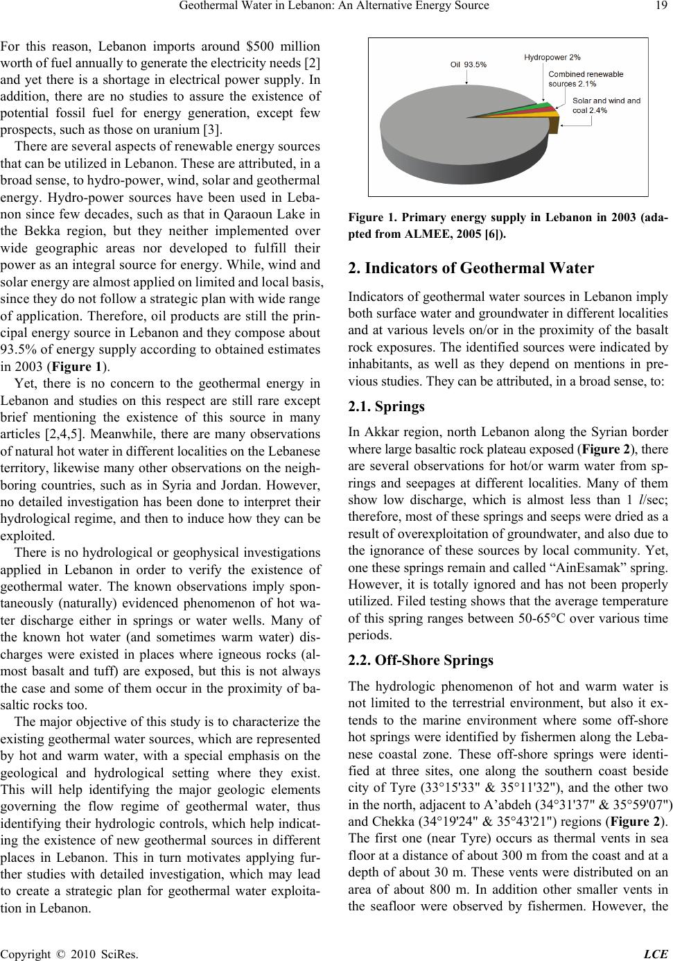 Geothermal Water in Lebanon: An Alternative Energy Source19 For this reason, Lebanon imports around $500 million worth of fuel annually to generate the electricity needs [2] and yet there is a shortage in electrical power supply. In addition, there are no studies to assure the existence of potential fossil fuel for energy generation, except few prospects, such as those on uranium [3]. There are several aspects of renewable energy sources that can be utilized in Lebanon. These are attributed, in a broad sense, to hydro-power, wind, solar and geothermal energy. Hydro-power sources have been used in Leba- non since few decades, such as that in Qaraoun Lake in the Bekka region, but they neither implemented over wide geographic areas nor developed to fulfill their power as an integral source for energy. While, wind and solar energy are almost applied on limited and local basis, since they do not follow a strategic plan with wide range of application. Therefore, oil products are still the prin- cipal energy source in Lebanon and they compose about 93.5% of energy supply according to obtained estimates in 2003 (Figure 1). Yet, there is no concern to the geothermal energy in Lebanon and studies on this respect are still rare except brief mentioning the existence of this source in many articles [2,4,5]. Meanwhile, there are many observations of natural hot water in different localities on the Lebanese territory, likewise many other observations on the neigh- boring countries, such as in Syria and Jordan. However, no detailed investigation has been done to interpret their hydrological regime, and then to induce how they can be exploited. There is no hydrological or geophysical investigations applied in Lebanon in order to verify the existence of geothermal water. The known observations imply spon- taneously (naturally) evidenced phenomenon of hot wa- ter discharge either in springs or water wells. Many of the known hot water (and sometimes warm water) dis- charges were existed in places where igneous rocks (al- most basalt and tuff) are exposed, but this is not always the case and some of them occur in the proximity of ba- saltic rocks too. The major objective of this study is to characterize the existing geothermal water sources, which are represented by hot and warm water, with a special emphasis on the geological and hydrological setting where they exist. This will help identifying the major geologic elements governing the flow regime of geothermal water, thus identifying their hydrologic controls, which help indicat- ing the existence of new geothermal sources in different places in Lebanon. This in turn motivates applying fur- ther studies with detailed investigation, which may lead to create a strategic plan for geothermal water exploita- tion in Lebanon. Figure 1. Primary energy supply in Lebanon in 2003 (ada- pted from ALMEE, 2005 [6]). 2. Indicators of Geothermal Water Indicators of geothermal water sources in Lebanon imply both surface water and groundwater in different localities and at various levels on/or in the proximity of the basalt rock exposures. The identified sources were indicated by inhabitants, as well as they depend on mentions in pre- vious studies. They can be attributed, in a broad sense, to: 2.1. Springs In Akkar region, north Lebanon along the Syrian border where large basaltic rock plateau exposed (Figure 2), there are several observations for hot/or warm water from sp- rings and seepages at different localities. Many of them show low discharge, which is almost less than 1 l/sec; therefore, most of these springs and seeps were dried as a result of overexploitation of groundwater, and also due to the ignorance of these sources by local community. Yet, one these springs remain and called “AinEsamak” spring. However, it is totally ignored and has not been properly utilized. Filed testing shows that the average temperature of this spring ranges between 50-65°C over various time periods. 2.2. Off-Shore Springs The hydrologic phenomenon of hot and warm water is not limited to the terrestrial environment, but also it ex- tends to the marine environment where some off-shore hot springs were identified by fishermen along the Leba- nese coastal zone. These off-shore springs were identi- fied at three sites, one along the southern coast beside city of Tyre (33°15'33" & 35°11'32"), and the other two in the north, adjacent to A’abdeh (34°31'37" & 35°59'07") and Chekka (34°19'24" & 35°43'21") regions (Figure 2). The first one (near Tyre) occurs as thermal vents in sea floor at a distance of about 300 m from the coast and at a depth of about 30 m. These vents were distributed on an area of about 800 m. In addition other smaller vents in the seafloor were observed by fishermen. However, the Copyright © 2010 SciRes. LCE 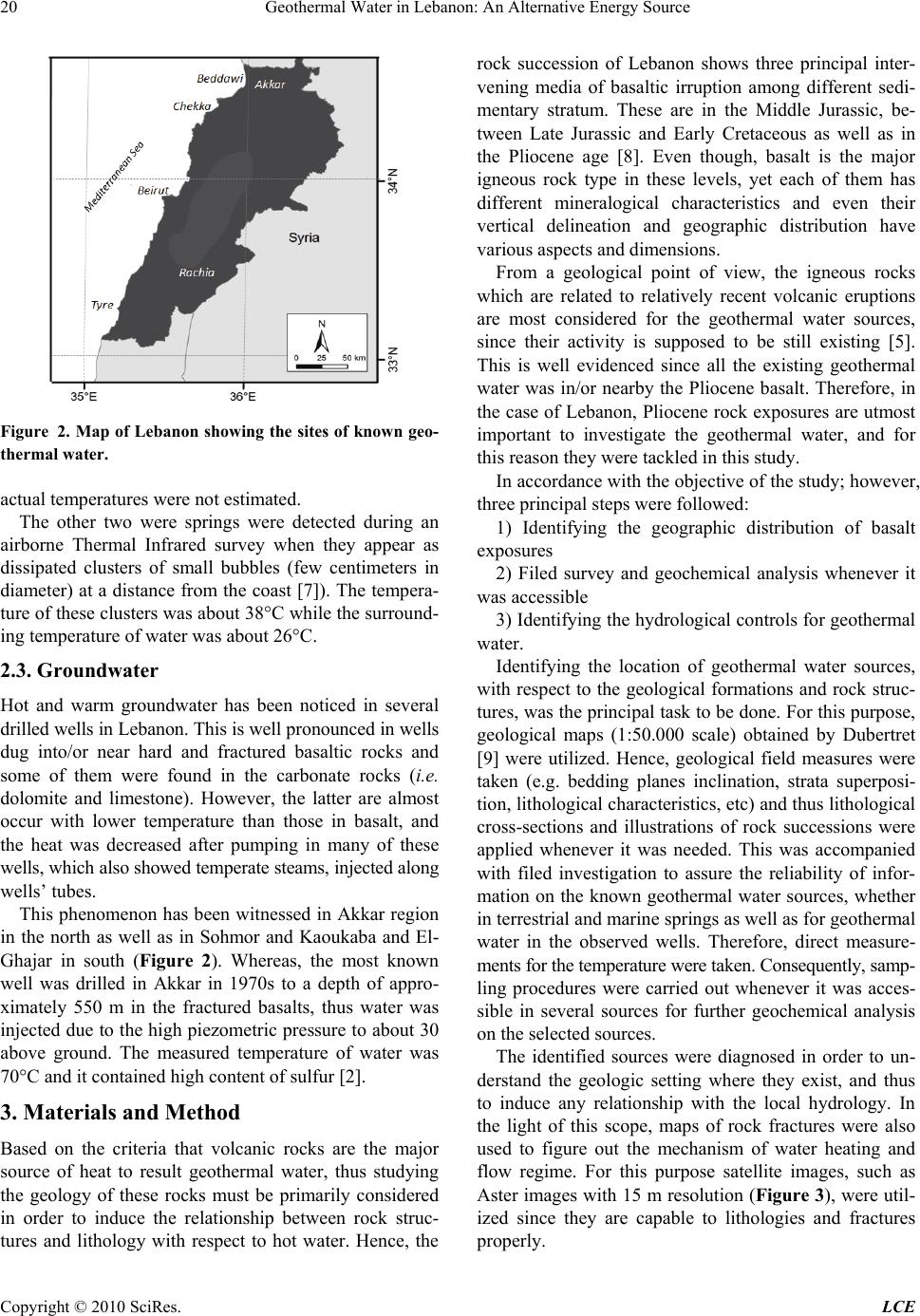 20 Geothermal Water in Lebanon: An Alternative Energy Source Figure 2. Map of Lebanon showing the sites of known geo- thermal water. actual temperatures were not estimated. The other two were springs were detected during an airborne Thermal Infrared survey when they appear as dissipated clusters of small bubbles (few centimeters in diameter) at a distance from the coast [7]). The tempera- ture of these clusters was about 38°C while the surround- ing temperature of water was about 26°C. 2.3. Groundwater Hot and warm groundwater has been noticed in several drilled wells in Lebanon. This is well pronounced in wells dug into/or near hard and fractured basaltic rocks and some of them were found in the carbonate rocks (i.e. dolomite and limestone). However, the latter are almost occur with lower temperature than those in basalt, and the heat was decreased after pumping in many of these wells, which also showed temperate steams, injected along wells’ tubes. This phenomenon has been witnessed in Akkar region in the north as well as in Sohmor and Kaoukaba and El- Ghajar in south (Figure 2). Whereas, the most known well was drilled in Akkar in 1970s to a depth of appro- ximately 550 m in the fractured basalts, thus water was injected due to the high piezometric pressure to about 30 above ground. The measured temperature of water was 70°C and it contained high content of sulfur [2]. 3. Materials and Method Based on the criteria that volcanic rocks are the major source of heat to result geothermal water, thus studying the geology of these rocks must be primarily considered in order to induce the relationship between rock struc- tures and lithology with respect to hot water. Hence, the rock succession of Lebanon shows three principal inter- vening media of basaltic irruption among different sedi- mentary stratum. These are in the Middle Jurassic, be- tween Late Jurassic and Early Cretaceous as well as in the Pliocene age [8]. Even though, basalt is the major igneous rock type in these levels, yet each of them has different mineralogical characteristics and even their vertical delineation and geographic distribution have various aspects and dimensions. From a geological point of view, the igneous rocks which are related to relatively recent volcanic eruptions are most considered for the geothermal water sources, since their activity is supposed to be still existing [5]. This is well evidenced since all the existing geothermal water was in/or nearby the Pliocene basalt. Therefore, in the case of Lebanon, Pliocene rock exposures are utmost important to investigate the geothermal water, and for this reason they were tackled in this study. In accordance with the objective of the study; however, three principal steps were followed: 1) Identifying the geographic distribution of basalt exposures 2) Filed survey and geochemical analysis whenever it was accessible 3) Identifying the hydrological controls for geothermal water. Identifying the location of geothermal water sources, with respect to the geological formations and rock struc- tures, was the principal task to be done. For this purpose, geological maps (1:50.000 scale) obtained by Dubertret [9] were utilized. Hence, geological field measures were taken (e.g. bedding planes inclination, strata superposi- tion, lithological characteristics, etc) and thus lithological cross-sections and illustrations of rock successions were applied whenever it was needed. This was accompanied with filed investigation to assure the reliability of infor- mation on the known geothermal water sources, whether in terrestrial and marine springs as well as for geothermal water in the observed wells. Therefore, direct measure- ments for the temperature were taken. Consequently, samp- ling procedures were carried out whenever it was acces- sible in several sources for further geochemical analysis on the selected sources. The identified sources were diagnosed in order to un- derstand the geologic setting where they exist, and thus to induce any relationship with the local hydrology. In the light of this scope, maps of rock fractures were also used to figure out the mechanism of water heating and flow regime. For this purpose satellite images, such as Aster images with 15 m resolution (Figure 3), were util- ized since they are capable to lithologies and fractures properly. Copyright © 2010 SciRes. LCE 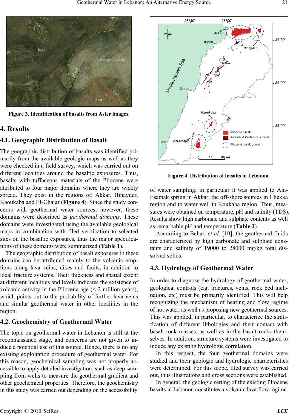 Geothermal Water in Lebanon: An Alternative Energy Source Copyright © 2010 SciRes. LCE 21 Figure 3. Identification of basalts from Aster images. 4. Results 4.1. Geographic Distribution of Basalt The geographic distribution of basalts was identified pri- marily from the available geologic maps as well as they were checked in a field survey, which was carried out on different localities around the basaltic exposures. Thus, basalts with tuffaceous materials of the Pliocene were attributed to four major domains where they are widely spread. They exist in the regions of: Akkar, Hinayder, Kaoukaba and El-Ghajar (Figure 4). Since the study con- cerns with geothermal water sources; however, these domains were described as geothermal domains. These domains were investigated using the available geological maps in combination with filed verification to selected sites on the basaltic exposures, thus the major specifica- tions of these domains were summarized (Table 1). Figure 4. Distribution of basalts in Lebanon. f water sampling; in particular it was applied to Ain- rmal fluids ar 4.3. Hydrology of Geothermal Water ermal water, omains were st ba o Esamak spring in Akkar, the off-shore sources in Chekka region and to water well in Koukaba region. Thus, mea- sures were obtained on temperature, pH and salinity (TDS). Results show high carbonate and sulphate contents as well as remarkable pH and temperature (Table 2). According to Bahati et al. [10], the geothe e characterized by high carbonate and sulphate cons- tants and salinity of 19000 to 28000 mg/kg total dis- solved solids. The geographic distribution of basalt exposures in these domains can be attributed mainly to the volcanic erup- tions along lava veins, dikes and faults, in addition to local fracture systems. Their thickness and spatial extent at different localities and levels indicates the existence of volcanic activity in the Pliocene age (< 2 million years), which points out to the probability of further lava veins and similar geothermal water in other localities in the region. In order to diagnose the hydrology of geoth geological controls (e.g. fractures, veins, rock bed incli- nation, etc) must be primarily identified. This will help recognizing the mechanism of heating and flow regime of hot water, as well as proposing new geothermal sources. This was applied, in particular, to characterize the strati- fication of different lithologies and their contact with basalt rock masses, as well as in the basalt rocks them- selves. In addition, structure systems were investigated to induce any existing hydrologic correlation. In this respect, the four geothermal d 4.2. Geochemistry of Geothermal Water The topic on geothermal water in Lebanon is still at the reconnaissance stage, and concerns are not given to in- duce a potential use of this source. Hence, there is no any existing exploitation procedure of geothermal water. For this reason, geochemical sampling was not properly ac- cessible to apply detailed investigation, such as deep sam- pling from wells to measure the geothermal gradient and other geochemical properties. Therefore, the geochemistry in this study was carried out depending on the accessibility udied and their geologic and hydrologic characteristics were determined. For this scope, filed survey was carried out, thus illustrations and cross sections were established. In general, the geologic setting of the existing Pliocene salts in Lebanon constitutes a volcanic lava flow regime.  Geothermal Water in Lebanon: An Alternative Energy Source Copyright © 2010 SciRes. LCE 22 L Coordinates* Table 1. Major basalt domains inebanon and their specifications. Geothermal domain Latitude Longitude Area† (km2) A (m. verage altitude Basalt characteristics a.sl) Akkar 34°35'15" 36°08'55" 135 Hinayder 34°36'50" 36°25'50" 24 Kaoukaba 33°23'40" 35°38'50" 17 El-Ghajar 33°16'20" 35°37'30" 33 400-450 - Massive basaltic plateau dominant with fracture systems, - Syenite and tuff occur in different localities and at different levels - Fluid inclusions appear as internal and external vascular pits, - Rose-basalt and calcite veins are common. 500-550 - Basaltic, syenite and tuff occur at various levels, - Surficila fluid inclusions are common, - Laval flow is featuring in several sites. 550-600 - Block basaltic lava with fumaroles - Fracture systems, mainly jointing is dominant 300-325 - Massive and boulder basalts, - Vertical joint and fracture systems are well de- veloped, - Calcite and iron veins exist, - Empty vascular cylindrical veins occur. *Coordinates in the mid-point area; †Area within Lebanon. ource Temperature TDS pH Table 2. Major geochemical measures of s Thermal s elected geothermal water in Lebanon. Ain-Esamak 65 °C 21008.3 0 mg/kg Chekka off-shore sources 38 °C Koukaba 18500 mg/kg 7.7 region well 35 °C 16000 mg/kg 7.4 ation (e.g. A an racture systems (i.e. recha zo . faults between Bire and he NE-SW direction and intersect mages [12]. This in turn in- ust be considered and given to have alternative energy sources, notably in the light of Thus, four interrelations were identified as follows: - Occurrence of massive basalt plateaus (e.g. Akkar, Hinayder and El-Ghajar domains) - Lava flow widely erupted among the carbonate rocks of the Cenomanian limestone rock formkkar along Er-Rafid and Kfer Mishka in Kaoukaba region. These faults compose geothermal fracture zones, which is a widely hydrologic phenomenon worldwide, likewise d Hinayder domains) - Lava flow erupted along the Cenomanian and Jurassic carbonates (e.g. El-Ghajar domain) - Lava flow erupted among or Cenomanian and related laying formations (e.g. Kaoukaba domain). Therefore, the internal heat affects the groundwater and results geothermal water following two mechanisms: - Heating within the basalt rock masses, which are characterized by intensive frge terprets the existence of geothermal water in the marine environment facing A’abdeh, Chekka and Tyre. ne), thus high permeability and porosity occur. The percolated (recharged) water into fractures was subjected to heat transfer from deep molten materials (Figure 5(a)). This might not be occurred unless the magma is shallow enough to heat directly the basalt. - Contact heating between the basalt rock masses and the adjacent carbonate rocks, which are almost of frac- tured and karstified limestone and dolomite aquifers (Fi- gure 5(b)) Accordingly, the existence of geothermal seepages and springs on terrain surface is attributed principally to the existing fault and fissure systems (Figure 5(b)), such as the case of the NE-SW trending Mantara in Akkar region along which the geothermal source of Ain Esamak is located. There is also a similar fault that trends in t those occur in Turkey and having similar characteristics as Lebanon [11]. Some of the intersecting faults between the basalt and the carbonate rocks have considerable length that ex- ceeds several tens of kilometers and reach the sea floor, as indicated from satellite i 5. Conclusions and Discussions Energy sources are not usually occurred spontaneously on terrain surface to indicating their existence, but they usually be discovered everywhere by human by applying several methods of investigation. Hence, looking for al- ternative energy sources m attention as much as the current usable sources. This must be applied to Lebanon the country with a great need  Geothermal Water in Lebanon: An Alternative Energy Source 23 Figure 5. Schematic figures showing various hydrology of geothermal water source. the existing physical and anthropogenic factors. This can be achieved if strategic plans for natural resources asse- ssment are applied. A surveillance and research studies, such as the current study, are utmost important. In Lebanon, other than hy- dro-power, wind and solar energy which are being limit- edly utilized as well as the currently discussed oil explo- ration; however, geothermal energy must be considered, especially by the governmental sectors. There are many indicators on the geothermal water sources in Lebanon, and they occur in various hydrologic aspects, which were tackled in this study. Yet, there is no detailed information on these sources. This study is an empirical attempt to characterize the existing sources and to put the first hand information on the geologic and hy- drologic setting of the geothermal water in Lebanon. It discusses the mechanism of groundwater heating in order to yield geothermal water. Based on the hydrologic controls in this study, it is obvious that geothermal groundwater in Lebanon is an existing source. It is also evidenced and anticipated to be existed on other sites where the Pliocene basalts are lo- cated with similar hydrologic properties. Therefore, the potential localities for geothermal water in Lebanon can be reached by drilling a number of wells on/near the ba- salt rock masses considering the following hydrological elements: 1) Fault alignments are potential sites for geothermal water, in particular along fault contacts between basalt masses and sedimentary rock sequences. This can be applied to the three trending faults mentioned previously y masses and not the sedimentary ones. 3) Deep sedimentary groundwater basins (i.e. aquifer- ous rock formations) that are located in a close proximity to Pliocene basalts are also potential for geothermal wa- ter sources, but a number of hydrogeological elements must be taken into account (e.g. hydraulic gradient, strata inclination, etc). In addition, the existing geothermal sources must be reinvestigated and then plans for exploitation must be put. Such as the Ain Esamak spring, which must be rehabili- tated, as well as all geothermal seeps and hot/warm water appears in wells must be investigated in depth. Moreover, the hydrologic conduits that transporting hot water to the sea should be also delineated in order to determine their sources on-land. REFERENCES [1] AEC, American Energy Commission, 2006. http://www1. eere.energy.gov/geothermal/history.html [2] A. Houri, “Renewable Energy Sources in Lebanon: Prac- tical Applications,” ISESCO Science and Technology Vi- sion, Vol. 1, 2005, pp. 65-68. [3] A. Shaban, “Geological Prospects for Uranium Deposits in Lebanon,” Environmental Hydrology Journal, Vol. 16, Paper 12, 2008. [4] GLA, “Status and Potentials of Renewable Energy Tech- nologies in Lebanon and the Region (Egypt, Jordan, Pal- estine, Syria),” Desk Study Complied by Green Line As- sociation, 2007. [5] A. Shaban, “The Geo-Thermal Energy in Lebanon,” Te- chnical Report (In Arabic), CNRS, 2009, p. 10. [6] ALMEE, “State of Energy in Lebanon,” Association li- banaise pour la maitrise de l’energi at l’environnement, 2005. http://www.Almee.org/pdf/state%20of%20the20% energy%20Lebanon.pdf [7] LCNRS, Lebanese National Council for Scientific Research, “Thermal Infrared Survey to Detect Submarine Springs along the Lebanese Coast,” Technical Report, 1999, p. 33. [8] Z. Beydoun, “Petroleum Prospects of Lebanon: Reevalu- ation,” American Association of Petroleum Geologists, Vol. 61, No. 1, 1977, pp. 43-64. [9] L. Dubertret, “Carte géologique de la Syrie et du Liban au 1/200000me,” 21 feuilles avec notices explicatrices, Ministère des Travaux Publics, L’imprimerie Catholique, Beyrouth, 1955, p. 74. [10] G. Bahati and F. Natukunda, “Status of Geothermal Ex- ploration and Development in Uganda,” Short Course III on the Exploration of Geothermal Resources, Kenya, 2008, p. 10. [11] U. Serpen, “Hydrogeological Investigations on Balcova in Akkar, Kaoukaba and El-Ghajar regions. 2) Fracture zones, and more certainly fissure systems, are also promising sites for geothermal water, but only those fissures occurred within the Pliocene basalt bod Copyright © 2010 SciRes. LCE  24 Geothermal Water in Lebanon: An Alternative Energy Source Copyright © 2010 SciRes. LCE Geothermal System in Turkey,” Geothermic, Vol. 33, No. 3, 2004, pp. 309-335. [12] A. Shaban, M. Khawlie, C. Abdallah and G. Faour, “Geo- logic Controls of Submarine Groundwater Discharge: Ap- plication of Remote Sensing to North Lebanon,” Envi- ronmental Geology, Vol. 47, No. 4, 2005, pp. 512-522. |