 Atmospheric and Climate Sciences, 2012, 2, 427-440 http://dx.doi.org/10.4236/acs.2012.24037 Published Online October 2012 (http://www.SciRP.org/journal/acs) Possible Impacts of Climate Change on Daily Streamflow and Extremes at Local Scale in Ontario, Canada. Part II: Future Projection Chad Shouquan Cheng1*, Qian Li1, Guilong Li1, Heather Auld2,3 1Science Section, Operations—Ontario, Meteorological Service of Canada, Environment Canada, Toronto, Canada 2Adaptation and Impacts Research Division, Science and Technology Branch, Environment Canada, Toronto, Canada 3Risk Science International (RSI) Inc., Toronto, Canada Email: *shouquan.cheng@ec.gc.ca Received May 10, 2012; revised June 14, 2012; accepted June 25, 2012 ABSTRACT The paper forms the second part of an introduction to possible impacts of climate change on daily streamflow and ex- tremes in the Province of Ontario, Canada. Daily streamflow simulation models developed in the companion paper (Part I) were used to project changes in frequency of future daily streamflow events. To achieve this goal, future climate in- formation (including rainfall) at a local scale is needed. A regression-based downscaling method was employed to downscale eight global climate model (GCM) simulations (scenarios A2 and B1) to selected weather stations for vari- ous meteorological variables (except rainfall). Future daily rainfall quantities were projected using daily rainfall simula- tion models with downscaled future climate information. Following these projections, future daily streamflow volumes can be projected by applying daily streamflow simulation models.The frequency of future daily high-streamflow events in the warm season (May-November) was projected to increase by about 45% - 55% late this century from the current condition, on average of eight-GCM A2 projections and four selected river basins. The corresponding increases for fu- ture daily low-streamflow events and future daily mean streamflow volume could be about 25% - 90% and 10% - 20%, respectively. In addition, the return values of annual one-day maximum streamflow volume for various return periods were projected to increase by 20% - 40%, 20% - 50%, and 30% - 80%, respectively for the periods 2001-50, 2026-75, and 2051-2100. Inter-GCM and interscenario uncertainties of future streamflow projections were quantitatively as- sessed. On average, the projected percentage increases in frequency of future daily high-streamflow events are about 1.4 - 2.2 times greater than inter-GCM and interscenario uncertainties. Keywords: Rainfall-Related Streamflow; Future Projection; Downscaling; Statistic Methods; Ontario; Canada 1. Introduction It is widely believed that in this century climate change might result in increased flooding in many regions over the globe, based on studies conducted in the past decades (see some of the references listed in Table 1). A number of studies have specifically focused on projecting chan- ges in future annual/seasonal average streamflow volum- es under a changing climate. In most of the studies, global climate model (GCM) projections are commonly used as the future climatic conditions. The GCM project- tions have been used in the studies in different ways: 1) GCM-implied changes applied to the observed daily cli- mate; 2) statistically downscaled GCM simulations; and 3) dynamically downscaled GCM data—regional climate model (RCM) simulations. In addition, hypothesized scenarios, such as increases in annual mean temperature of 1˚C, 2˚C, 4˚C and/or changes in annual precipitation of ±5%, ±10%, ±20%, relative to the baseline climate, were used in the analysis on hydrological impacts of cli- mate change. GCM-implied changes were applied to the observed rainfall and potential evaporation to generate inputs for conceptual or semi-distributed rainfall-runoff hydrologi- cal simulation models (e.g., [1-5]). The change values that are derived from averaging multi-year monthly GCM outputs are applied to daily or even hourly ob- served data [6]. In addition to changes derived from GCM projections, the hypothesized scenarios were used as the input to hydrological models to project future wa- ter balance components (e.g., [7,8]). To project future climates required by hydrological models, daily and hourly observed hydrometeorological variables, such as temperature and rainfall, were modified by adding a sin- *Corresponding author. C opyright © 2012 SciRes. ACS  C. S. CHENG ET AL. 428 gle change value for a month or whole study period. It seems that this assumption might not be practical since it does not account for the anticipated changes to the vari- ability of future climate [9,10]. As was done to project climate change impacts on streamflow at a local scale, another option is to apply don scaled simulations of GCMs to hydrological mod- w els. In addition to dynamic downscaling approach (i.e., RCMs) to project future flood frequency (e.g., [6,11]), another leading technique is statistical (empirical) down- scaling [12]. The statistical downscaling methods have been widely used in hydrometeorology to project changes in frequency of future high-streamflow or rainfall-driven flood events [13-18]. Table 1. Examples of previous studies on climate change and streamflow. Scenarios Reference Hydrological Model Key Results Study Area Bultot et al. [1] Conceptual hydrological model (IRMB), Winter streamflow could increase in all of the study basins; direction of summer flow change depends on basin types under a 2 × CO2 condition Belgium Panagoulia & Dimou [2] Conceptual hydrological model Flood frequency, duration, and volume could increase for all in- creased precipitation HYPO and GISS scenarios Central Greece Sefton & Boorman [32] Unit hydrograph-based model Mean annual flow could increase by up to 60% in most of the region under a 2 × CO2 condition England and Wales, UK Gellens & Roulin [33] IRMB Flood frequency could increase, especially in winter season under a 2 × CO2 condition Belgium Arnell [34] Catchment hydrological model Winter (DJF)/summer (JJA) streamflow could increase/decrease Six rivers in UK Eckhardt & Ulbrich [35] Conceptual hydrological model: Soil & Water Assessment Tool Winter (DJF)/summer (JJA) streamflow could increase/decrease by 10%/50% by 2070-2099 Rhenish Massif, Germany Drogue et al. [3] HRM (conceptual Hydrological Recursive Model) Daily mean discharge could increase, the magnitude of which de pends upon the rainfall change scenarios by the 2050s Grand Duchy of Luxembourg Cameron [4] TOPMODEL (semi-distributed model)Direction of the change by the 2080s varies among the GCMs Northeastern Scotland, UK GCM-implied changes applied to the observed daily climate Forbes et al. [5] ACRU agro-hydrological modeling system Winter /spring streamflows could increase and summer/fall stream flows could decrease in the middle and late of this century Southern Al erta, Canada Najjar [13] Statistical and water balance models Annual streamflow could increase by 24% ± 13% under a 2 × CO2 condition Pennsylvania, US Whitfield et al. [14] Hydrograph-based model Frequency of rainfall-driven floods could increase in all watersheds under the projected climate scenarios; rainfall-related low flows could maintain the same frequency and magnitude Georgia Basin, BC, Canada Dettinger et al. [15] PPMS (physically based Precipitation-Runoff Modeling System) Winter and summer streamflow could increase and decease in the 21st century Three rivers in California, US Jasper et al. [16] WaSiM-ETH (Water Flow and Balance Simulation Model) Winter (DJF)/summer (JJA) runoffs could increase/decrease by 14% - 31%/16% - 33% at two basins by 2081-2100 Two Alpine river basins, Switzerland Dibike & Coulibaly [17] Distributed hydrological models: Swedish & Canadian models Early spring streamflow could dramatically increase; winter flow could increase and summer flow could decrease in the 21st century Northern Quebec, Canada Statistically downscaled GCM scenarios Merritt et al. [18] Semi-distributed conceptual models Annual, spring, and winter flow volumes could decrease by the 2050s and 2080s Okanagan Basin, Canada Kay et al. [6] Simplified probability distributed model Flood frequency could increase by the 2080s in most of catchments Fifteen rivers across UK RCM scenarios Sushama et al. [11] RCM outputs directly Annual and seasonal (except summer) streamflow in Canadian river basins (i.e., Mackenzie, Yukon, Fraser) could increase in the future (2041-2070) Six river basins, North America Arnell & Reynard [36] Conceptual hydrological models Annual flow could increase over 20% for the wettest scenarios and decline over 20% for the driest scenarios by 2050 21 catchments in UK Panagoulia & Dimou [7] Monthly water balance model Summer runoff could decrease by 50% for the driest scenario; winter runoff could increase by 60% for the wettest scenario Central Greece Hypothesized scenarios Jiang et al. [8] Six monthly water balance models The six-model results are similar in reproducing historical water balance components but different in estimating future changes Southern China Copyright © 2012 SciRes. ACS  C. S. CHENG ET AL. 429 The statistical downscaling scheme used in this cur- rent study is built upon the previous studies (i.e., Cheng et al. [19-21]) for deriving future hydrometeorological variables that were used in development of daily stream- flow simulation models (constructed in Part I, [22]), which is made up of a four-step process. First, daily rainfall simulation models were developed and validated using synoptic weather typing with cumulative logit re- gression and nonlinear regression procedures [20]. The simulation models consider physical process of rainfall formation since the theories combining from both con- ceptual and statistical modeling were applied in the model development. To more effectively develop daily rainfall simulation models, the study [20] has used a number of the atmospheric stability indices in addition to the standard meteorological variables that were com- monly used in most of the previous rainfall downscaling papers. Second, regression-based downscaling transfer functions developed by Cheng et al. [19] are adapted to derive station-scale future hourly meteorological vari- ables (except rainfall) that were used in development of daily rainfall simulation models. Third, using down- scaled future hourly climate data, future daily rainfall quantity can be projected by applying synoptic weather typing and daily rainfall simulation models [21]. Finally, it is able to project future daily streamflow volumes by applying daily streamflow simulation models [22] with down- scaled future daily rainfall and temperature data. This paper is organized as follows: in Section 2, data sources and their treatments are described. Section 3 summarizes the previous studies (Cheng et al. [19-21]) on future daily rainfall projection on which the current paper was built. Section 4 describes analysis techniques as applied to projection of future daily streamflow vol- umes. Section 5 includes the results and discussion on 1) changes in frequencies of future daily high- and low- streamflow events, 2) changes in future return values of one-day maximum streamflow events, and 3) uncertainty of the study and limitations of the data. The conclusions and recommendations from the study are summarized in Section 6. 2. Data Sources To project future daily streamflow volumes using stream- flow simulation models developed in a companyion pa- per (Part I: Historical simulation, Cheng et al. [22]), the historical observations and future projections of the me- teorological/hydrological elements are essential. Histori- cal observations include daily surface meteorological/ hydrological data (i.e., rainfall, temperature, streamflow) within the four selected river basins, which were used in daily streamflow simulation modeling described in Part I [22]. The future projections include 1) future local-scale daily rainfall quantities projected by a recent study (Cheng et al. [21]), using daily rainfall simulation mod- els developed by Cheng et al. (2010) and 2) station-scale daily temperature down-scaled by a statistical down- scaling approach developed by Cheng et al. [19]. To bet- ter understand the study, the relevant information on pro- jection of future daily rainfall and extremes as well as statistical down-scaling will be summarized in Section 3. In addition to historical observations and projections of future daily rainfall quantities, daily climate change simulations from eight GCM models and two emission scenarios from the Fourth Assessment Report (AR4) of the Intergovernmental Panel on Climate Change (IPCC) were used in the study, summarized in Table 2. The eight GCM models were selected since their simulations of all weather elements, including surface and upper-air temperature, dew point, air pressure, total cloud cover, u-wind and v-wind are available. These climate change simulations were retrieved from the Web site of the Pro- gram for Climate Model Diagnosis and Intercomparison [23]. The PCMDI is archiving the GCM simulations for two future time periods (2046-2065 and 2081-2100). Fur- thermore, the historical runs of these GCM simulations for the period (1961-2000) were used to remove the GCM model bias from the projection of future daily streamflow volumes. These three time windows were used in the analysis because these data are only available from the PCMDI’s Web site. Furthermore, for project- tions of future return-period values of annual maximum high-streamflow events, three CGCM transient model simulations for a 100-year period (2001-2100) were in- cluded (Table 2), which were retrieved from Environ- ment Canada’s Web site [24]. 3. Summary of Future Daily Rainfall Projection As part of this research, Cheng et al. [21] have projected future daily rainfall quantities using daily rainfall simula- tion models (Cheng et al. [20]) with downscaled stan- dard meteorological variables derived from statistical downscaling transfer functions (Cheng et al. [19]). Since the results and methods from these studies were used and adopted in this current paper to project changes in fre- quency of future daily streamflow events, it is necessary to outline these studies focusing on major methods and results. As described in a recent study (Cheng et al. [21]), to project future daily rainfall amounts, the station-scale future climate data of the meteorological variables are necessary for the use of within-weather-type daily rain- fall simulation models developed by Cheng et al. [20]. To derive future hourly station-scale climate information from GCM-scale simulations, Cheng et al. [19] have developed a regression-based statistical downscaling Copyright © 2012 SciRes. ACS  C. S. CHENG ET AL. 430 Table 2. GCM simulations and scenarios used in the study. GCM IPCC scenario Periods CGCM3.1/T63 CNRM-CM3 CSIRO-Mk3.0 ECHAM5/MPI ECHO-G GFDL-CM2.0 GISS-ER MIRoc3.2 (medres) IPCC AR4 SRES A2/B1 1961-2000 2046-2065 2081-2100 For return period analysis: CGCM1 CGCM2 IPCC Third Assessment Report (TAR) SRES A2/B2 2001-2100 Note: IPCC AR4—Intergovernmental Panel on Climate Change, Fourth Assessment Report; SRES—Special Report on Emissions Scenarios; CGCM3.1/T63—Canadian global climate model (the 3rd generation, T63 version); CNRM-CM3—French global climate model (the 3rd generation) developed atocenter National Weather Research; CSIRO-Mk3.0—Aus- tralian global climate model (the 3rd generation) developed by the Com- monwealth Scientific and Industrial Research Organization; ECHAM5— Germany global climate model (the 5th generation) developed by the Max Plank Institute for Meteorology in Hamburg; ECHO-G—Germany and Korean global climate model consisting of the atmospheric model ECHAM4 and the ocean model HOPE (Hamburg ocean Primitive Equation); GFDL- CM2—US global climate model (the 2nd generation) developed by Geo- physical Fluid Dynamics Laboratory; GISS-ER—US global climate model developed by Goddard Institute for Space Studies, NASA. MIRoc3.2 (medres)—Japanese global climate model (the 3rd generation, med-res. version), Model for Interdisciplinary Research on Climate. method to spatially downscale daily GCM simulations to the selected weather stations in south-central Canada and then to temporally downscale daily scenarios to hourly timesteps. The downscaling transfer functions were con- structed using different regression methods for different meteorological variables since a regression method is suitable only for a certain kind of data with a specific distribution. The downscaled meteorological variables include surface and upper-air temperature, dew point temperature, west-east and south-north winds, air pressure, and total cloud cover. These weather parameters are es- sential to project future daily rainfall quantities using rainfall simulation models constructed via combination of an automated synoptic weather typing and cumulative logit/nonlinear regression analyses. Performance of the downscaling transfer functions was evaluated by 1) ana- lyzing model R2s of downscaling transfer functions; 2) validating downscaling transfer functions using a leave- one-year-out cross-validation scheme; and 3) comparing data distributions, extreme characteristics, and seasonal/ diurnal changes of downscaled GCM historical runs ver- sus observations over a comparative time period of 1961- 2000. The results showed that regression-based down- scaling methods performed very well in deriving station- scale hourly and daily climate information for all weather variables. For example, the hourly downscaling transfer functions for surface air temperatures, dewpoint, and sea level air pressure possess the highest model R2 (>0.95) of the weather elements. The functions for south- north wind speed (y wind) are the weakest model (model R2s ranging from 0.69 to 0.92 with half of them greater than 0.89). Details of the hourly and daily downscaling methodologies and evaluations of the results are not pre- sented in this current paper owing to the limitations of space (refer to Cheng et al. [19] for details). Following downscaling of the meteorological variables, future daily rainfall amounts are able to be projected us- ing within-weather-type daily rainfall simulation models developed by Cheng et al. [20,21]. As described in the study [20], 10 synoptic weather types in the study area were identified over the 45-yr period as primary rainfall- related weather types. Within-weather-type daily rainfall simulation models were developed in a two-step process: 1) cumulative logit regression to predict the occurrence of daily rainfall events; and 2) using probability of the logit regression, a nonlinear regression procedure to simulate daily rainfall quantities. To more effectively distinguish heavy rainfall events, the daily rainfall simu- lation models were constructed using not only the stan- dard meteorological variables but also a number of the atmospheric stability indices (e.g., lifted index [25], K-index [26], total totals index [27]). The performance of within-weather-type daily rainfall simulation models was evaluated, and as described by Cheng et al. [20], the re- sults showed that the models were successful at verifying occurrence of daily rainfall events and daily rainfall quantities. Cheng et al. [20] have found that, across the four selected river basins, the percentage of excellent and good daily rainfall-quantity simulations ranged from 62% to 84%, based on absolute difference between ob- served and simulated daily rainfall amounts. In addition, it is noteworthy that the rainfall simulation models are able to capture most of daily heavy rainfall events (i.e., ≥32.5 mm) with the percentage of excellent and good simulations: 62%, 68%, 70%, and 81% for Grand, Tha- mes, Humber, and Rideau River Basins, respectively. Following development of daily rainfall simulation models, future daily rainfall and its extremes were pro- jected by applying within-weather-type rainfall simula- tion models altogether with downscaled future GCM climate data. Cheng et al. [21] have used three GCMs and two emission scenarios (A2 and B2) from the IPCC Third Assessment Report (TAR) to project future daily rainfall and its extremes. Since climate simulations from eight GCMs and two IPCC AR4 emission scenarios A2 and B1 were used in this current study, it is necessary to update projections of future daily rainfall quantities using these downscaled updated GCM simulations. The number of future seasonal rain days and future seasonal rainfall totals projected by rainfall simulation models versus his- torical observations are graphically illustrated in Figure 1. The rainfall projections were evaluated by comparing Copyright © 2012 SciRes. ACS 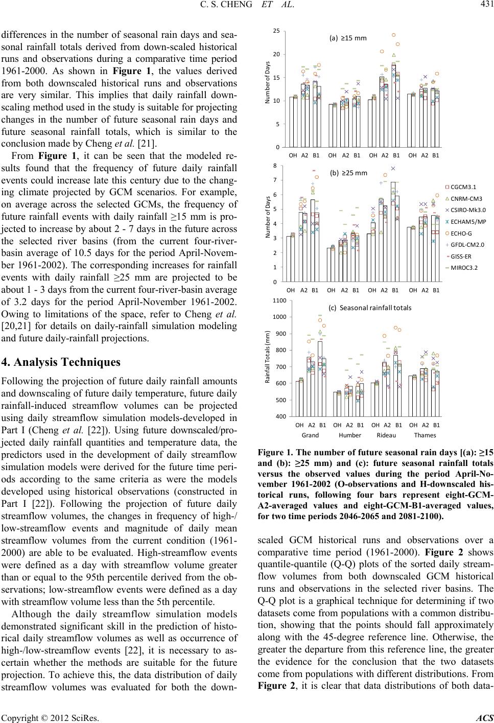 C. S. CHENG ET AL. 431 differences in the number of seasonal rain days and sea- sonal rainfall totals derived from down-scaled historical runs and observations during a comparative time period 1961-2000. As shown in Figure 1, the values derived from both downscaled historical runs and observations are very similar. This implies that daily rainfall down- scaling method used in the study is suitable for projecting changes in the number of future seasonal rain days and future seasonal rainfall totals, which is similar to the conclusion made by Cheng et al. [21]. From Figure 1, it can be seen that the modeled re- sults found that the frequency of future daily rainfall events could increase late this century due to the chang- ing climate projected by GCM scenarios. For example, on average across the selected GCMs, the frequency of future rainfall events with daily rainfall ≥15 mm is pro- jected to increase by about 2 - 7 days in the future across the selected river basins (from the current four-river- basin average of 10.5 days for the period April-Novem- ber 1961-2002). The corresponding increases for rainfall events with daily rainfall ≥25 mm are projected to be about 1 - 3 days from the current four-river-basin average of 3.2 days for the period April-November 1961-2002. Owing to limitations of the space, refer to Cheng et al. [20,21] for details on daily-rainfall simulation modeling and future daily-rainfall projections. 4. Analysis Techniques Following the projection of future daily rainfall amounts and downscaling of future daily temperature, future daily rainfall-induced streamflow volumes can be projected using daily streamflow simulation models-developed in Part I (Cheng et al. [22]). Using future downscaled/pro- jected daily rainfall quantities and temperature data, the predictors used in the development of daily streamflow simulation models were derived for the future time peri- ods according to the same criteria as were the models developed using historical observations (constructed in Part I [22]). Following the projection of future daily streamflow volumes, the changes in frequency of high-/ low-streamflow events and magnitude of daily mean streamflow volumes from the current condition (1961- 2000) are able to be evaluated. High-streamflow events were defined as a day with streamflow volume greater than or equal to the 95th percentile derived from the ob- servations; low-streamflow events were defined as a day with streamflow volume less than the 5th percentile. Although the daily streamflow simulation models demonstrated significant skill in the prediction of histo- rical daily streamflow volumes as well as occurrence of high-/low-streamflow events [22], it is necessary to as- certain whether the methods are suitable for the future projection. To achieve this, the data distribution of daily streamflow volumes was evaluated for both the down- 400 500 600 700 800 900 1000 1100 RainfallTotals(mm) (c)Sea so nalrainfalltotals OHA2B1OH A2 B1OHA2B1OHA2B1 0 1 2 3 4 5 6 7 8 Num b erofDays (b) ≥25mm CGCM3.1 CNRM‐CM3 CSIRO‐Mk3.0 ECHAM5/MP ECHO‐G GFDL‐CM2.0 GISS‐ER MIROC3.2 OHA2 B1OHA2B1OH A2B1OH A2 B1 0 5 10 15 20 25 Num b erofDays (a) ≥15mm OHA2B1OHA2B1OHA2 B1OH A2 B1 Grand Humber RideauThames Figure 1. The number of future seasonal rain days [(a): ≥15 and (b): ≥25 mm) and (c): future seasonal rainfall totals versus the observed values during the period April-No- vember 1961-2002 (O-observations and H-downscaled his- torical runs, following four bars represent eight-GCM- A2-averaged values and eight-GCM-B1-averaged values, for two time periods 2046-2065 and 2081-2100). scaled GCM historical runs and observations over a comparative time period (1961-2000). Figure 2 shows quantile-quantile (Q-Q) plots of the sorted daily stream- flow volumes from both downscaled GCM historical runs and observations in the selected river basins. The Q-Q plot is a graphical technique for determining if two datasets come from populations with a common distribu- tion, showing that the points should fall approximately along with the 45-degree reference line. Otherwise, the greater the departure from this reference line, the greater the evidence for the conclusion that the two datasets come from populations with different distributions. From Figure 2, it is clear that data distributions of both data- Copyright © 2012 SciRes. ACS 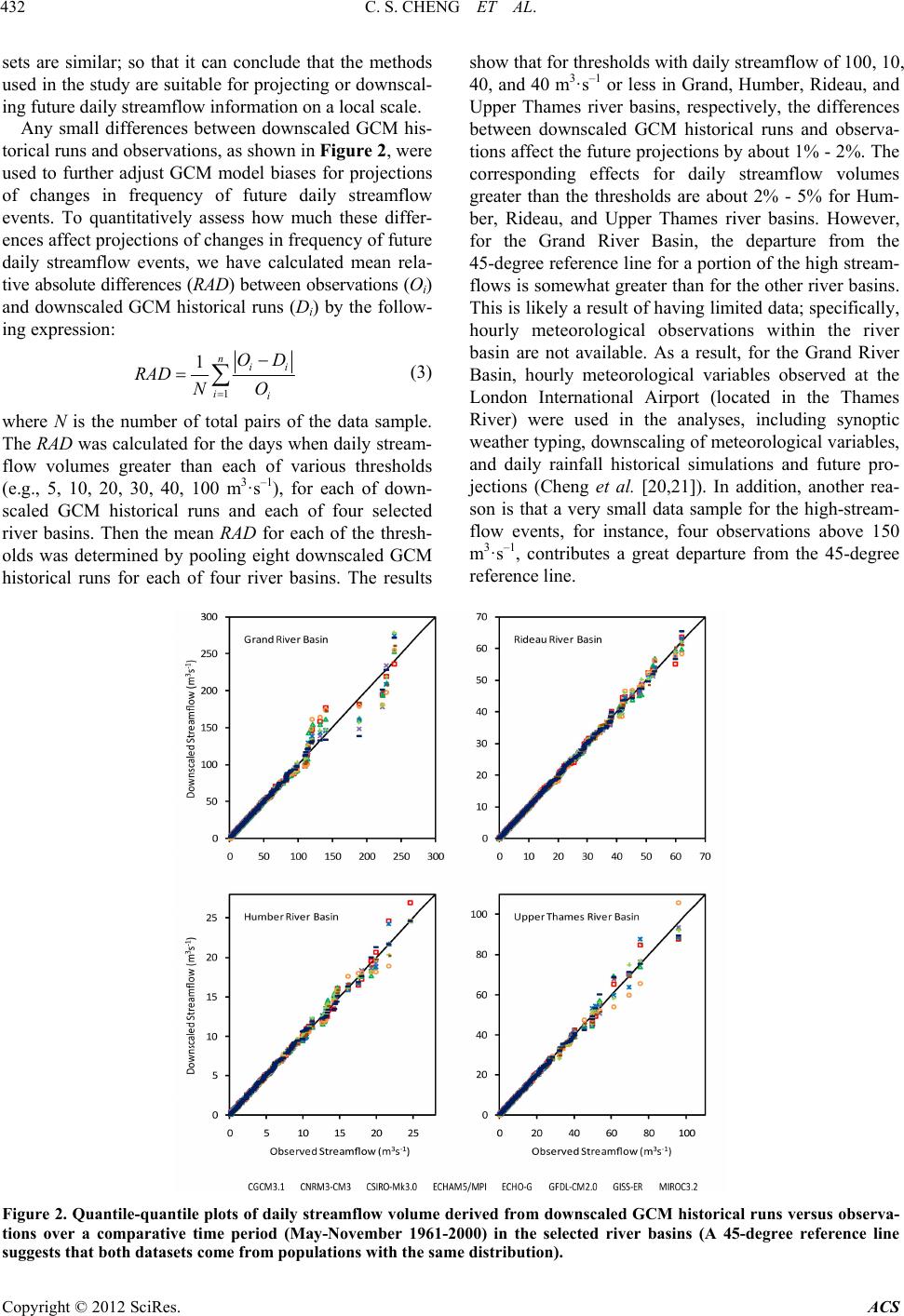 C. S. CHENG ET AL. Copyrig ACS 432 sets are similar; so that it can conclude that the methods used in the study are suitable for projecting or downscal- ing future daily streamflow information on a local scale. show that for thresholds with daily streamflow of 100, 10, 40, and 40 m3·s–1 or less in Grand, Humber, Rideau, and Upper Thames river basins, respectively, the differences between downscaled GCM historical runs and observa- tions affect the future projections by about 1% - 2%. The corresponding effects for daily streamflow volumes greater than the thresholds are about 2% - 5% for Hum- ber, Rideau, and Upper Thames river basins. However, for the Grand River Basin, the departure from the 45-degree reference line for a portion of the high stream- flows is somewhat greater than for the other river basins. This is likely a result of having limited data; specifically, hourly meteorological observations within the river basin are not available. As a result, for the Grand River Basin, hourly meteorological variables observed at the London International Airport (located in the Thames River) were used in the analyses, including synoptic weather typing, downscaling of meteorological variables, and daily rainfall historical simulations and future pro- jections (Cheng et al. [20,21]). In addition, another rea- son is that a very small data sample for the high-stream- flow events, for instance, four observations above 150 m3·s–1, contributes a great departure from the 45-degree reference line. Any small differences between downscaled GCM his- torical runs and observations, as shown in Figure 2, were used to further adjust GCM model biases for projections of changes in frequency of future daily streamflow events. To quantitatively assess how much these differ- ences affect projections of changes in frequency of future daily streamflow events, we have calculated mean rela- tive absolute differences (RAD) between observations (Oi) and downscaled GCM historical runs (Di) by the follow- ing expression: 1 1nii ii OD NO RAD (3) where N is the number of total pairs of the data sample. The RAD was calculated for the days when daily stream- flow volumes greater than each of various thresholds (e.g., 5, 10, 20, 30, 40, 100 m3·s–1), for each of down- scaled GCM historical runs and each of four selected river basins. Then the mean RAD for each of the thresh- olds was determined by pooling eight downscaled GCM historical runs for each of four river basins. The results Figure 2. Quantile-quantile plots of daily streamflow volume derived from downscaled GCM historical runs versus observa- tions over a comparative time period (May-November 1961-2000) in the selected river basins (A 45-degree reference line suggests that both datasets come from populations with the same distribution). ht © 2012 SciRes. 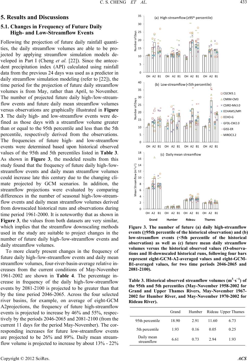 C. S. CHENG ET AL. 433 5. Results and Discussions 0 5 10 15 20 25 30 35 NumberofDay s (a) High‐streamflow(≥95 th percentile) OHA2B1 OHA2B1OHA2 B1OHA2B1 5.1. Changes in Frequency of Future Daily High- and Low-Streamflow Events Following the projection of future daily rainfall quanti- ties, the daily streamflow volumes are able to be pro- jected by applying streamflow simulation models de- veloped in Part I (Cheng et al. [22]). Since the antece- dent precipitation index (API) calculated using rainfall data from the previous 24 days was used as a predictor in daily streamflow simulation modeling (refer to [22]), the time period for the projection of future daily streamflow volumes is from May, rather than April, to November. The number of projected future daily high-/low-stream- flow events and future daily mean streamflow volumes versus observations are graphically illustrated in Figure 3. The daily high- and low-streamflow events were de- fined as those days with a streamflow volume greater than or equal to the 95th percentile and less than the 5th percentile, respectively derived from the observations. The frequencies of future high- and low-streamflow events were determined based upon historical observed values of the 95th and 5th percentiles listed in Table 3. As shown in Figure 3, the modeled results from this study found that the frequency of future daily high-/low- streamflow events and daily mean streamflow volumes could increase late this century due to the changing cli- mate projected by GCM scenarios. In addition, the streamflow projections were evaluated by comparing differences in the number of seasonal high-/low-stream- flow events and daily mean streamflow volumes derived from downscaled historical runs and observations during time period 1961-2000. It is noteworthy that as shown in Figure 3, the values from both datasets are very similar, which implies that the streamflow downscaling methods used in the study are suitable to project changes in the number of future daily high-/low-streamflow events and daily streamflow volumes. To more clearly present changes in the frequency of future daily high-/low-streamflow events and daily mean streamflow volumes, four-river-basin-average relative in- creases from the current conditions of May-November 1961-2002 are shown in Table 4. The percentage in- crease in frequency of the daily high-/low-streamflow events by 2081-2100 is projected to be greater than that by the time period 2046-2065. Across the four selected river basins, for example, on average of eight-GCM A2projections, the frequency of future high-streamflow events is projected to increase by 46% and 55%, respec- tively by the periods 2046-2065 and 2081-2100 (from the current 11 days for the period May-November). The cor- responding increases for future low-streamflow events are projected to be 26% and 89%. Daily mean stream- flow volume is projected to increase by about 13% - 22% Gra nd Humber Rideau Thames 0 5 10 15 20 25 30 35 40 NumberofDays (b ) Low‐streamflow(<5thpercentile) CGCM3.1 CNRM ‐CM3 CSIRO‐Mk3.0 ECHAM5/MPI ECHO‐G GFDL‐CM2.0 GISS‐ER MIROC3.2 OH A2B1OH A2 B1 OHA2 B1OH A2B1 0 2 4 6 8 10 12 14 16 18 MeanStreamflow(m 3 ∙s ‐1 ) (c)Dailymeanstreamflow OHA2B1OHA2B1OHA2B1OHA2B1 0 5 10 15 20 25 30 35 NumberofDay s (a) High‐streamflow(≥95 th percentile) OHA2B1 OHA2B1OHA2 B1OHA2B1 0 5 10 15 20 25 30 35 40 NumberofDays (b ) Low‐streamflow(<5thpercentile) CGCM3.1 CNRM ‐CM3 CSIRO‐Mk3.0 ECHAM5/MPI ECHO‐G GFDL‐CM2.0 GISS‐ER MIROC3.2 OH A2B1OH A2 B1 OHA2 B1OH A2B1 0 2 4 6 8 10 12 14 16 18 MeanStreamflow(m 3 ∙s ‐1 ) (c)Dailymeanstreamflow OHA2B1OHA2B1OHA2B1OHA2B1 Gra nd Humber Rideau Thames Figure 3. The number of future (a) daily high-streamflow events (≥95th percentile of the historical observation) and (b) low-streamflow events (<5th percentile of the historical observation) as well as (c) future mean daily streamflow volumes versus the historical observed values (O-observa- tions and H-downscaled historical runs, following four bars represent eight-GCM-A2-averaged values and eight-GCM- B1-averaged values, for two time periods 2046-2065 and 2081-2100). Table 3. Historical observed streamflow volumes (m3·s−1) of the 95th and 5th percentiles (May-November 1958-2002 for Grand and Upper Thames Rivers, May-November 1967- 2002 for Humber River, and May-November 1970-2002 for Rideau River). Grand Humber Rideau Upper Thames 95th percentile 18.90 2.91 11.60 6.73 5th percentile 1.93 0.16 0.05 0.25 Daily mean streamflow 6.61 0.73 2.94 1.93 Copyright © 2012 SciRes. ACS  C. S. CHENG ET AL. 434 late this century. In addition, the projected four-river- basin-averaged percentage increases derived from eight- GCM ensemble A2 scenario are greater than those from B1 scenario for the period 2081-2100; while the in- creases are very similar between two scenarios for the period 2046-2065. These projected increases are associ- ated with GCM simulations: temperature increases be- tween scenarios A2 and B1 are very similar for the pe- riod 2046-2065; however, for the period 2081-2100, the increases simulated from scenario A2 are greater than those from B1. As shown in Figure 3, the projections of future daily high-/low-streamflow events and daily mean stream- flow volumes vary across the selected GCMs. To eva- luate performance of GCMs’ projections, the individual GCM’s projections were compared with eight-GCM- average changes to determine which GCMs’ projections with the closest to or the most faraway from averaged future projection. A case with the closest to averaged future projection was defined as a relative change in fu- ture projection is within 10% around the average, while a case with the most faraway from averaged future projec- tion was defined as a relative change is more than 50% higher or lower than the average. From Table 5, it can be seen that the top three best-performed GCMs having the highest numbers of the cases with the closest to and the lowest numbers of the cases with the most faraway from eight-GCM-average relative changes are GFDL-CM2— US global climate model (the 2nd generation), CNRM- CM3—French global climate model (the 3rd generation), and ECHAM5—Germany global climate model (the 5th generation). While the worst performed GCMs are MI- Roc3.2 (medres)—Japanese global climate model (the 3rd generation, med-res. version) and GISS-ER—US global climate model. The projected increases in the frequency of future high-streamflow events might be due to the potential increase in the frequency of future heavy rainfall events projected by downscaled future GCM scenarios [21]. Possible reasons for an increase in the frequency of fu- ture low-streamflow events might be an increase in the frequency and severity of future drought condition and the magnitude of future evapotranspiration in summer- time. Although future seasonal rainfall totals in the study Table 4. Four-river-basin-averaged percentage increases in the frequency of future seasonal high-streamflow/low-streamflow days and future daily mean streamflow volumes from the current conditions of May-November 1961-2002, presented by eight-GCM A2 and B1 ensemble. Eight-GCM A2 Eight-GCM B1 Streamflow events Current conditions 2046-2065 2081-2100 2046-2065 2081-2100 High-streamfow (≥95th percentile) 10.7 days 46 55 44 45 Low-streamflow (<5th percentile) 10.4 days 26 89 25 55 Daily mean streamflow 0.74 - 6.68 m3·s–1 13 22 13 13 Table 5. Evaluation on GCM’s projections of future daily streamflow derived from Figure 3: the number of cases with the closest to the eight-GCM ensemble future projection (defined as a relative change is within 10% around the average); the number of cases with the most faraway from the eight-GCM ensemble future projection (defined as a relative change is at least 50% higher or lower than the average). Closest to averaged future projections Most faraway from averaged future projections GCM Grand Humber Rideau Thames Total Grand Humber Rideau Thames Total CGCM3 5 6 6 3 20 3 1 0 3 7 CNRM3 3 7 6 8 24 1 1 0 2 4 CSIRO3 4 6 2 4 16 5 3 2 4 14 ECHAM5 2 7 5 7 21 2 0 1 0 3 ECHO 3 8 2 6 19 4 2 4 2 12 GFDL-CM2 6 7 5 5 23 0 0 0 2 2 GISS-ER 3 5 0 5 13 4 1 10 1 16 MIRoc3 1 1 1 6 9 0 8 6 2 16 Total 27 47 27 44 145 19 16 23 16 74 Copyright © 2012 SciRes. ACS  C. S. CHENG ET AL. 435 area are projected to increase under a changing climate, the number of days without rainfall or with a little rain- fall is also projected to be greater than is currently the case. For example, the number of future annual average no-rain days in Upper Thames River Basin is projected to increase by about 5% from the average condition of 137 days during the period 1961-2002. Furthermore, the fu- ture warmer temperatures projected by the GCM models could also enhance the low-streamflow situation due to increased evapotranspiration capacities. 5.2. Changes in Future Return Values of One-day Maximum Streamflow Events The statistical return period analysis was employed to project the return values of one-day maximum stream- flow events for a number of return periods. A return pe- riod also known as a recurrence interval is an estimate of the likelihood of events like one-day maximum stream- flow volume of a certain intensity. It is a statistial mea- surement denoting the average recurrence interval over an extended period of time. Return values are thresholds that will be exceeded on average once every return pe- riod. The design of stormwater infrastructure is cons- trained by the largest precipitation/streamflow event anti- cipated during a fixed design period (e.g., 20, 50 or 100 years). Due to climate change, the return values of one- day maximum streamflow events could increase in the future. To project future return values of one-day maximum streamflow events, an annual series of historical one-day maximum streamflow events were fitted to the Gumbel (Extreme Value Type I) distribution for each of the se- lected river basins. The streamflow data observed for the entire period used in the study were applied to determine the return values for the historical period. The projected future daily streamflow data, using three downscaled CGCM simulations for three 50-year periods (2001-2050, 2026-2075, and 2051-2100), were used to project future return values. The results showed that the projected re- turn values of the one-day maximum streamflow events for all evaluated return periods (e.g., 20, 25, 30, 50, 100 years) could increase late this century (Figure 4). For example, in the Grand River Basin, the 20-year return period values of one-day maximum streamflow events are 173 m3·s–1 for the past 45 years and potentially 240, 256, and 311 m3·s–1 for the periods 2001-2050, 2026- 2075, and 2051-2100, respectively. 0 50 100 150 200 250 300 350 400 450 500 0 102030405060708090100 One-day Maximum Streamflow (m 3 s -1 ) Grand River Basin 0 20 40 60 80 100 120 0 102030405060708090100 Rideau River Basin 0 20 40 60 80 100 120 0 102030405060708090100 Return Period (Number of Years) Upper Thames River Basin 0 5 10 15 20 25 30 35 40 45 0 102030405060708090100 Return period (Number of Years) One-day Maximum Streamflow (m 3 s -1 ) Humber River Basin Observation 2001–2050 2026–2075 2051–2100 Figure 4. Return values of annual one-day maximum streamflow volumes as shown by observation (Grand and Upper Thames: 1961-2002; Humber: 1967-2002; Rideau: 1970-2002) and downscaled three-CGCM ensemble (2001-2050, 2026-2075, and 2051-2100). Copyright © 2012 SciRes. ACS  C. S. CHENG ET AL. 436 In addition to the increase in return values shown in Figure 4, the relative increases in future return values of one-day maximum streamflow volume from the current condition were analyzed. The relative increases are more similar across the return periods and the river basins than the absolute increases of the return values, as shown in Table 6. Across the selected river basins, on average of the three downscaled CGCM simulations, the return val- ues of the one-day maximum streamflow volume for various return periods (i.e., 2, 5, 10, 15, 20, 25, 30, 50, 100 years) are projected to increase by approximately 15% - 40%, 25% - 50%, and 30% - 80% in the future three 50-year periods 2001-2050, 2026-2075, and 2051- 2100, respectively. More specifically, for example, in the Grand River Basin, the 20-year return-period values of one-day maximum streamflow volume for future three 50-year periods are projected to increase by 39%, 48%, and 80%, respectively from the observed value of 173 m3·s–1 for the past 45 years. Among the three down- scaled CGCM simulations, the projected percentage increases in the return values are similar, usually with slightly greater values derived from downscaled CGCM- A2 than those from downscaled CGCM-B2. For exam- ple, across four selected river basins, the difference in the percentage increases between downscaled CGCM2- A2 and CGCM2- B2 is usually less than 10% for future three 50-year periods, with a few exemptions. In addi- tion, from Table 6, it can be seen that the 95% confi- dence interval for future projected return-period values is similar to the observed ones, which implies that the future projected return-period values are plausibly reliable. Table 6. Percentage increases in future annual one-day maximum streamflow volumes for various return periods (down- scaled three-CGCM ensemble) from current observed values (95% confidence interval in parentheses). Thames River Basin Grand River Basin Obs. 2001-20502026-2075 2051-2100Obs. 2001-2050 2026-2075 2051-2100 Return Period (Year) (m3/s) (%) (%) (%) (m3/s) (%) (%) (%) 2 20 (±7.5) 36 (±6.5)44 (±5.6) 56 (±5.2)61 (±5.9) 23 (±9.8) 35 ( ±11) 53 ( ±11) 5 38 (±5.0) 21 (±4.3)27 (±3.7) 36 (±3.4)110 (±4.1) 34 (±6.7) 44 (±7.6) 72 (±7.5) 10 50 (±5.2) 16 (±4.4)22 (±3.8) 31 (±3.5)142 (±4.3) 37 (±7.0) 46 (±7.9) 77 (±7.8) 15 56 (±5.4) 15 (±4.5)21 (±3.9) 29 (±3.6)160 (±4.4) 38 (±7.3) 47 (±8.2) 79 (±8.1) 20 61 (±5.4) 14 (±4.6)20 (±4.0) 28 (±3.7)173 (±4.5) 39 (±7.5) 48 (±8.4) 80 (±8.3) 25 64 (±5.6) 13 (±4.7)19 (±4.0) 27 (±3.8)183 (±4.6) 39 (±7.6) 48 (±8.5) 81 (±8.5) 30 67 (±5.7) 13 (±4.8)19 (±4.1) 26 (±3.8)191 (±4.7) 40 (±7.7) 49 (±8.7) 81 (±8.6) 50 75 (±5.9) 12 (±4.9)17 (±4.2) 25 (±4.0)213 (±4.7) 41 (±8.0) 49 (±9.0) 83 (±8.9) 100 86 (±6.0) 11 (±5.1)16 (±4.4) 24 (±4.1)243 (±4.9) 41 (±8.3) 50 (±9.3) 84 (±9.3) Mean 17 (±4.9)23 (±4.2) 31 (±3.9) 37 (±7.8) 46 (±8.7) 76 (±8.7) Humber River Basin Rideau River Basin Obs. 2001-2050 2026-2075 2051-2100 Obs. 2001-2050 2026-2075 2051-2100 Return Period (Year) (m3/s) (%) (%) (%) (m3/s) (%) (%) (%) 2 10 (±3.0) 20 (±6.5) 26 (±8.3) 28 (±7.8) 21 (±4.3) 58 (±5.1) 64 (±6.7) 73 (±6.1) 5 14 (±2.1) 26 (±5.6) 40 (±7.2) 44 (±6.7) 34 (±3.2) 41 (±3.8) 50 (±5.0) 54 (±4.6) 10 16 (±3.1) 29 (±6.3) 46 (±8.1) 51 (±7.6) 43 (±3.7) 35 (±4.1) 45 (±5.4) 48 (±5.0) 15 18 (±2.8) 30 (±6.7) 48 (±8.7) 53 (±8.1) 48 (±3.8) 33 (±4.3) 43 (±5.6) 46 (±5.2) 20 19 (±3.2) 30 (±7.0) 50 (±9.1) 55 (±8.5) 52 (±3.8) 31 (±4.4) 42 (±5.8) 44 (±5.4) 25 20 (±3.0) 31 (±7.2) 51 (±9.3) 56 (±8.7) 55 (±4.0) 30 (±4.5) 41 (±5.9) 43 (±5.5) 30 20 (±3.5) 31 (±7.4) 52 (±9.6) 57 (±8.9) 57 (±4.0) 30 (±4.6) 40 (±6.0) 43 (±5.6) 50 22 (±3.6) 32 (±7.8) 53 ( ±10) 59 (±9.5) 63 (±4.3) 28 (±4.8) 39 (±6.3) 41 (±5.8) 100 25 (±3.6) 33 (±8.4) 56 ( ±11) 61 ( ±10) 71 (±4.5) 26 (±5.0) 38 (±6.6) 39 (±6.1) Mean 29 (±7.0) 47 (±9.0) 52 (±8.4) 35 (±4.5) 45 (±5.9) 48 (±5.5) Note: To effectively compare the 95% confidence intervals between observed and future projected return values, as the same as the future projections, the 95% confidence intervals derived from observations are presented as percentages below or above the return values. Copyright © 2012 SciRes. ACS  C. S. CHENG ET AL. 437 5.3. Uncertainty and Limitations The uncertainty of climate change impacts on future heavy rainfall events described in a recent study (Cheng et al. [21]) also applies to this paper since the projection of future daily rainfall quantities was used in the current study to project future daily streamflow volumes. As described in the study [21], considerable effort was made to transfer GCM-scale simulations to station-scale cli- mate information using statistical downscaling transfer functions. Through the downscaling process, most of the GCM model bias was removed, using the 50-year his- torical relationships between regional-scale predictors and station-scale weather elements [28]. As a result, the quality of the GCM climate change projections was much improved after using the statistical downscaling (Cheng et al. [19]). However, conclusions made in the current study about the impacts of climate change on future high-/low-streamflow events still rely on GCM scenarios/projections and, consequently, there is corre- sponding uncertainty about the study findings. To quantitatively assess inter-GCM and interscenario uncertainties of future daily streamflow projections, we have analyzed the four-river-basin-average absolute dif- ference between pairs of eight selected GCM models under the SRES B1 scenario as well as absolute differ- ence between two selected scenarios (A2 versus B1). The absolute difference used in analysis is to avoid negative values cancelling out positive values. As shown in Table 7, overall, the inter-GCM uncertainties of percentage increases in the frequency of future daily high-stream- flow events are greater than the interscenario uncertain- ties. For daily mean streamflow projections, both uncer- tainties are similar. From Tables 5 and 7, it can be seen that the uncertainties of future daily high-streamflow events are smaller than the future projections. The overall mean projected percent- age increases in frequency of future daily high-stream- flow events are about 1.4 - 2.2 times greater than overall mean inter-GCM and intersce- nario uncertainties. For projections of future daily low- streamflow events and daily mean streamflow volumes, the inter-GCM and interscenario uncertainties are gener- ally similar to or greater than the projected future per- centage increases. Although the models developed from this study can simulate most high-streamflow events for the selected river basins, it was found that the models have difficulty in capturing some of the cases, especially for urban river basins, such as the Black Creek tributary of the Humber River (refer to Part I, Cheng et al. [22]). This model limitation is also reflected by the simulation difficulty of the localized convective heavy rainfall events. As de- scribed by Cheng et al. [20], the rainfall simulation mod- els can simulate most heavy rainfall events, but it was found that the models have difficulty in capturing some of localized convective heavy rainfall events. It is likely that projection of changes in frequency of future rain- fall-related high-streamflow events offered by this study will represent the lower bound values for the study area. As a result, southern Ontario could in the future possibly receive more rainfall-related high-streamflow events than is currently projected by the study. In addition to uncertainty of GCM projections and limitation of daily streamflow simulation models, the observed streamflow data used in the study have their limitation. Daily mean streamflow volumes which are averaged over a 24-hour period (i.e., 00:00-23:00 LST, local standard time) are currently used in the analysis. Daily streamflow data are limited in their usefulness for studying more detailed information on the simulation of the high-streamflow events, especially for rapidly rain- fall-streamflow responding urban watersheds (e.g., the Black Creek tributary of the Humber River). If the short- duration (less than one day) streamflow data were avail- able, the streamflow simulation model for Humber River Basin could possibly be improved by using streamflow information at a shorter time step. Furthermore, the limitation of meteorological data, described in the study [21] for developing rainfall simu- lation models, also affect daily streamflow historical simulation and future projection. The major limitation of Table 7. Four-river-basin-average inter-GCM and interscenario uncertainties of projected percentage increases in the fre- quency of future seasonal high-streamflow/low-streamflow days and future daily mean streamflow volumes from the current conditions of May-November 1961-2002. Uncertainty (absolute difference) Mean 8-GCM B1a Mean 8-GCM A2 - B1b Streamflow events Current conditions 2046-2065 2081-2100 2046-2065 2081-2100 High-streamfow (≥95th percentile) Low-streamflow (<5th percentile) Daily mean streamflow 10.7 days 10.4 days 0.74 - 6.68 m3s–1 32 40 19 40 40 21 20 28 11 31 53 21 aMean 8-GCM B1 is average of absolute differences between pairs of eight GCM B1 models; bMean 8-GCM A2 - B1 is average of absolute differences be- tween scenarios A2 and B1 of eight GCM models. Copyright © 2012 SciRes. ACS  C. S. CHENG ET AL. 438 meteorological data includes that hourly meteorological observations are not available in the Grand River Basin, which are essential to develop synoptic weather typing and rainfall simulation models. Consequently, hourly meteorological data gathered at the London International Airport (located in Thames watershed) were used to clas- sify synoptic weather types and to derive rainfall predic- tors (e.g., atmospheric stability indices) for the Grand River. Therefore, the rainfall simulation results, derived for the Grand River Basin, were not as accurate as they might be were hourly meteorological data for the Grand River Basin available. In turn, these results could affect projection of frequency of future heavy rainfall events and ultimately influence on projections of frequency of future high-streamflow events derived from this study. 6. Conclusions and Recommendation The overall purpose of this study is to project possible changes in the frequency of high-/low-streamflow events late this century for four selected river basins (i.e., Grand, Humber, Rideau, and Upper Thames) in Ontario, Canada. To achieve this goal, the streamflow simulation models developed in Part I (Cheng et al. [22]) were applied col- lectively with downscaled future GCM simulations. As described in the studies (Cheng et al. [19,22]), a formal verification process of model results has been built into the whole exercise, comprising daily streamflow simula- tion modeling and the development of downscaling transfer functions. The study results demonstrate that the streamflow simulation models are able to reproduce daily streamflow volumes in the observed period for the se- lected river basins, through model calibration and verifi- cation. Furthermore, in this current study, the streamflow simulation models were evaluated using downscaled GCM historical runs to ascertain whether the models are suitable for projecting future daily streamflow volumes. The results of the verification in terms of data distribu- tion and frequency of the high-/low-streamflow events, based on historical observations of the outcome variables simulated by the models, showed good agreement. As a result, a general conclusion from this study is that a combination of the streamflow modeling and statistical downscaling can be useful to project changes in fre- quency of future daily high-/low-streamflow events. The modeled results from this study found that due to a changing climate, the frequency of future high- and low-streamflow events for the period 2046-2065 is pro- jected by averaging eight-GCM A2 projections to in- crease by about 45% and 25%, respectively from the current condition, which are similar to the increases by averaging eight-GCM B1 projections. The corresponding increases for the period 2081-2100 are much different between two scenarios: high-streamflow events will in- crease by 45% and 55% derived from eight-GCM sce- narios B1 and A2, respectively; for low-streamflow events, the corresponding increases are 55% and 89%. These findings are consistent with the results reported in the IPCC Fourth Assessment Report [29], in terms of the increase tendency in high- and low-streamflow events. The implication of these increases should be taken into consideration when revising engineering infrastructure design standards (including infrastructure maintenance and new construction) and developing adaptation strate- gies and policies. As the IPCC [29] pointed out, “More extensive adaptation than is currently occurring is re- quired to reduce vulnerability to future climate change.” This study aims to provide decision makers with scien- tific information needed to improve the adaptive capacity of the infrastructure at risk of being impacted by heavy rainfall-related flooding in Ontario due to climate change. The results of the study are intended to contribute to the Ontario Emergency Management and Civil Protection Act under Bill 148, which attempts to reduce risks of dis- asters by requiring that all municipalities, regional gov- ernments, and provincial ministries develop emergency and disaster risk management plans [30,31]. 7. Acknowledgements The authors gratefully acknowledge the funding support of the Government of Canada’s Climate Change Impacts and Adaptation Program (CCIAP), which made this re- search project (A901) possible. We also acknowledge the suggestions made by the Project Advisory Committee, which greatly improved the study REFERENCES [1] F. Bultot, A. Coppens, G. L. Dupriez, D. Gellens and F. Meulenberghs, “Repercussions of a CO2 Doubling on the Water Cycle and on the Water Balance—A Case Study for Belgium,” Journal of Hydrology, Vol. 99, No. 3-4, 1988, pp. 319-347. doi:10.1016/0022-1694(88)90057-1 [2] D. Panagoulia and G. Dimou, “Sensitivity of Flood Events to Global Climate Change,” Journal of Hydrology, Vol. 191, No. 1-4, 1997, pp. 208-222. doi:10.1016/S0022-1694(96)03056-9 [3] G. Drogue, L. Pfister, T. Leviandier, A. El Idrissi, J-F. Iffly, P. Matgen, J. Humbert and L. Hoffmann, “Simulat- ing the Spatio-Temporal Variability of Streamflow Re- sponse to Climate Change Scenarios in a Mesoscale Ba- sin,” Journal of Hydrology, Vol. 293, No. 1-4, 2004, pp. 255-269. doi:10.1016/j.jhydrol.2004.02.009 [4] D. Cameron, “An Application of the UKCIP02 Climate Change Scenarios to Flood Estimation by Continuous Simulation for a Gauged Catchment in the Northeast of Scotland, UK (with Uncertainty),” Journal of Hydrology, Vol. 328, No. 1-2, 2006, pp. 212-226. doi:10.1016/j.jhydrol.2005.12.024 Copyright © 2012 SciRes. ACS  C. S. CHENG ET AL. 439 [5] K. A. Forbes, S. W. Kienzle, C. A. Coburn, J. M. Byrne and J. Rasmussen, “Simulating the Hydrological Re- sponse to Predicted Climate Change on a Watershed in Southern Alberta, Canada,” Climatic Change, Vol. 105, No. 3-4, 2011, pp. 555-576. doi:10.1007/s10584-010-9890-x [6] A. L. Kay, R. G. Jones and N. S. Reynard, “RCM Rain- fall for UK Flood Frequency Estimation. II. Climate Change Results,” Journal of Hydrology, Vol. 318, No. 1-4, 2006, pp. 163-172. doi:10.1016/j.jhydrol.2005.06.013 [7] D. Panagoulia and G. Dimou, “Linking Space—Time Scale in Hydrological Modelling with Respect to Global Climate Change: Part 2. Hydrological Response for Al- ternative Climates,” Journal of Hydrology, Vol. 194, No. 1-4, 1997, pp. 38-63. doi:10.1016/S0022-1694(96)03221-0 [8] T. Jiang, Y. D. Chen, C. Y. Xu, X. H. Chen, X. Chen and V. P. Singh, “Comparison of Hydrological Impacts of Climate Change Simulated by Six Hydrological Models in the Dongjiang Basin, South China,” Journal of Hy- drology, Vol. 336, 2007, pp. 316-333. [9] A. W. Wood, D. P. Lettenmaier and R. N. Palmer, “As- sessing Climate Change Implications for Water Resources Planning,” Climatic Change, Vol. 37, No. 1, 1997, pp. 203-228. doi:10.1023/A:1005380706253 [10] L. E. Hay, R. L. Wilby and G. H. Leavesley, “A Com- parison of Delta Change and Downscaled GCM Scenarios for Three Mountainous Basins in the United States,” Journal of American Water Resources Association, Vol. 36, No. 2, 2000, pp. 387-397. doi:10.1111/j.1752-1688.2000.tb04276.x [11] L. Sushama, R. Laprise, D. Caya, A. Frigonb and M. Slivitzkyb, “Canadian RCM Projected Climate-Change Signal and Its Sensitivity to Model Errors,” International Journal of Climatology, Vol. 26, No. 15, 2006, pp. 2141- 2159. doi:10.1002/joc.1362 [12] R. L. Wilby and T. M. L. Wigley, “Downscaling General Circulation Model Output: A Review of Methods and Limitations,” Progress in Physical Geography, Vol. 21, No. 4, 1997, pp. 530-548. doi:10.1177/030913339702100403 [13] R. G. Najjar, “The Water Balance of the Susquehanna River Basin and Its Response to Climate Change,” Jour- nal of Hydrology, Vol. 219, No. 1-2, 1999, pp. 7-19. doi:10.1016/S0022-1694(99)00041-4 [14] P. H. Whitfield, J. Y. Wang and A. J. Cannon, “Model- ling Future Streamflow Extremes—Floods and Low Flows in Georgia Basin, British Columbia,” Canadian Water Resources Journal, Vol. 28, No. 4, 2003, pp. 633- 656. doi:10.4296/cwrj2804633 [15] M. D. Dettinger, D. R. Cayan, M. K. Meyer and A. E. Jeton, “Simulated Hydrologic Responses to Climate Varia- tions and Change in the Merced, Carson, and American River Basins, Sierra Nevada, California, 1900-2099,” Climatic Change, Vol. 62, No. 1-3, 2004, pp. 283-317. doi:10.1023/B:CLIM.0000013683.13346.4f [16] K. Jasper, P. Calanca, D. Gyalistras and J. Fuhrer, “Dif- ferential Impacts of Climate Change on the Hydrology of Two Alpine River Basins,” Climatic Research, Vol. 26, No. 2, 2004, pp. 113-129. doi:10.3354/cr026113 [17] Y. B. Dibike and P. Coulibaly, “Hydrologic Impact of Climate Change in the Saguenay Watershed: Comparison of Downscaling Methods and Hydrologic Models,” Journal of Hydrology, Vol. 307, No. 1-4, 2005, pp. 145-163. doi:10.1016/j.jhydrol.2004.10.012 [18] W. S. Merritt, Y. Alisa, M. Barton, B. Taylor, S. Cohen and D. Neilsen, “Hydrologic Response to Scenarios of Climate Change in Sub-Watersheds of the Okanagan Ba- sin, British Columbia,” Journal of Hydrology, Vol. 326, 2006, No. 1-4, pp. 79-108. doi:10.1016/j.jhydrol.2005.10.025 [19] C. S. Cheng, G. Li, Q. Li and H. Auld, “Statistical Downscaling of Hourly and Daily Climate Scenarios for Various Meteorological Variables in South-Central Can- ada,” Theoretical and Applied Climatology, Vol. 91, No. 1-4, 2008, pp. 129-147. doi:10.1007/s00704-007-0302-8 [20] C. S. Cheng, G. Li, Q. Li and H. Auld, “A Synoptic Weather Typing Approach to Simulate Daily Rainfall and Extremes in Ontario, Canada: Potential for Climate Change Projections,” Journal of Applied Meteorology and Cli- matology, Vol. 49, No. 5, 2010, pp. 845-866. doi:10.1175/2010JAMC2016.1 [21] C. S. Cheng, G. Li, Q. Li and H. Auld, “A Synoptic Weather-Typing Approach to Project Future Daily Rain- fall and Extremes at Local Scale in Ontario, Canada,” Journal of Climate, Vol. 24, No. 14, 2011, pp. 3667-3685. doi:10.1175/2011JCLI3764.1 [22] C. S. Cheng, Q. Li, G. Li and H. Auld, “Possible Impacts of Climate Change on Daily Streamflow and Extremes at Local Scale in Ontario, Canada,” Part I: historical simula- tion. Atmospheric and Climate Sciences, Vol. 2, No. 4, 2012, pp. 416-426. [23] PCMDI, “WCRP CMIP3 Multi-Model Dataset,” 2008. http://www-pcmdi.llnl.gov/ipcc/about_ipcc.php [24] Environment Canada, “DATA,” 2006. http://www.cccma.bc.ec.gc.ca/data/data.shtml [25] J. G. Galway, “The Lifted Index as a Predictor of Latent Instability,” Bulletin of the American Meteorological So- ciety, Vol. 37, 1956, pp. 528-529. [26] J. J. George, “Weather Forecasting for Aeronautics,” Academic Press, Waltham, 1960. [27] R. C. Miller, “Notes on Analysis and Severe Storm Fore- casting Procedures of the Air Force Global Weather Cen- tral,” Technical Report 200(R), Headquarters US Air Weather Service, Omaha, 1972. [28] R. W. Katz, “Techniques for Estimating Uncertainty in Climate Change Scenarios and Impact Studies,” Climatic Research, Vol. 20, No. 2, 2002, pp. 167-185. doi:10.3354/cr020167 [29] IPCC, “Summary for Policymakers,” In: S. Solomon, D. Qin, M. Manning, Z. Chen, M. Marquis, K. B. Averyt, M. Tignor and H. L. Miller, Eds., Climate Change 2007: The Physical Science Basis. Contribution of Working Group I to the Fourth Assessment Report of the Intergovernmental Panel on Climate Change, Cambridge University Press, Copyright © 2012 SciRes. ACS  C. S. CHENG ET AL. Copyright © 2012 SciRes. ACS 440 Cambridge and New York, 2007, 18 pp. [30] Ontario Management Act: Legislative Assembly of On- tario. “Bill 148 2002: An Act to Provide for Declarations of Death in Certain Circumstances and to Amend the Emergency Plans Act,” 2006. http://www.ontla.on.ca/documents/Bills/37_Parliament/S ession3/b148ra_e.htm [31] H. Auld, D. MacIver, J. Klaassen, N. Comer and B. Tug- wood, “Atmospheric Hazards in Ontario,” ACSD Science Assessment Series No. 3 Meteorological Service of Can- ada, Environment Canada, Toronto, 2004. [32] C. E. M. Sefton and D. B. Boorman, “A Regional Inves- tigation of Climate Change Impacts on UK Streamflows,” Journal of Hydrology, Vol. 195, No. 1-4, 1997, pp. 26-44. doi:10.1016/S0022-1694(96)03257-X [33] D. Gellens and E. Roulin, “Streamflow Response of Bel- gian Catchments to IPCC Climate Change Scenarios,” Journal of Hydrology, Vol. 210, No. 1-4, 1998, pp. 242- 258. doi:10.1016/S0022-1694(98)00192-9 [34] N. W. Arnell, “Relative Effects of Multi-Decadal Cli- matic Variability and Changes in the Mean and Variabil- ity of Climate due to Global Warming: Future Stream- flows in Britain,” Journal of Hydrology, Vol. 270, No. 3-4, 2003, pp. 195-213. doi:10.1016/S0022-1694(02)00288-3 [35] K. Eckhardt and U. Ulbrich, “Potential Impacts of Cli- mate Change on Groundwater Recharge and Streamflow in a Central European Low Mountain Range,” Journal of Hydrology, Vol. 284, No. 1-4, 2003, pp. 244-252. doi:10.1016/j.jhydrol.2003.08.005 [36] N. W. Arnell and N. S. Reynard, “The Effects of Climate Change due to Global Warming on River Flows in Great Britain,” Journal of Hydrology, Vol. 183, No. 3-4, 1996, pp. 397-424. doi:10.1016/0022-1694(95)02950-8
|