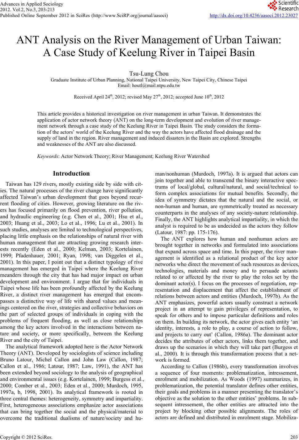
 Advances in Applied Sociology 2012. Vol.2, No.3, 203-213 Published Online September 2012 in SciRes (http://www.SciRP.org/journal/aasoci) http://dx.doi.org/10.4236/aasoci.2012.23027 Copyright © 2012 SciRe s . 203 ANT Analysis on the River Management of Urban Taiwan: A Case Study of Keelung River in Taipei Basin Tsu-Lung Chou Graduate Institute of Urban Planning, National Taipei University, New Taipei City, Chinese Taipei Email: houtl@mail.ntpu.edu.tw Received April 24th, 2012; revised May 27th, 2012; accepted June 10th, 2012 This article provides a historical investigation on river management in urban Taiwan. It demonstrates the application of actor network theory (ANT) on the long-term development and evolution of river manage- ment network through a case study of the Keelung River in Taipei Basin. The study considers the forma- tion of the actors’ world of the Keelung River and the way the actors have affected flood drainage and the supply of land in the region. River management and induced disasters in the Basin are explored. Strengths and weaknesses of the ANT are also discussed. Keywords: Actor Network Theory; River Management; Keelung River Watershed Introduction Taiwan has 129 rivers, mostly existing side by side with cit- ies. The natural processes of the river change have significantly affected Taiwan’s urban development that goes beyond recur- rent flooding of cities. However, growing literature on the riv- ers has focused primarily on flood prevention, river pollution, and hydraulic engineering (e.g. Chen et al., 2001; Hsu et al., 2003; Huang et al., 2003; Lo et al., 1996; Lu et al., 2001). In such studies, analyses are limited to technological perspectives, placing little emphasis on the relationships of natural river with human management that are attracting growing research inter- ests recently (Eden et al., 2000; Kelman, 2003; Kortelainen, 1999; Pfadenhauer, 2001; Ryan, 1998; van Diggelen et al., 2001). In this paper, I point out that a distinct typology of rive management has emerged in Taipei where the Keelung River meanders through the city that has had major impact on urban development and environment. I argue that for individuals in Taipei whose life has been profoundly affected by the Keelung River, a distinct river management has emerged that encom- passes a distinctive way of life with shared values and mean- ings centered on the river, strategies and collective behaviors on the part of selected groups of individuals in coping with the problems of frequent flooding, as well as close relationships among the key actors involved in the interactions between na- ture and society, or more specifically, between the Keelung River and the city of Taipei. The analytical framework adopted here is the Actor Network Theory (ANT). Developed by sociologists of science including Bruno Latour, Michel Callon and John Law (Callon, 1987; Callon et al., 1986; Latour, 1987; Law, 1991), the ANT has been extended beyond sociology to the analysis of geographical and environmental issues (e.g. Kortelainen, 1999; Burgess et al., 2000; Comber et al., 2003; Eden et al., 2000; Murdoch, 1995, 1997a, b, 1998, 2001). Its analytical framework is rooted in three central themes: heterogeneity, symmetry and impartiality. First, heterogeneous associations emphasize actor associations that can bring together the social and the physical/material to overcome the traditional dualisms of nature/society and hu- man/nonhuman (Murdoch, 1997a). It is argued that actors can join together and able to transcend the binary interactive spec- trums of local/global, cultural/natural, and social/technical to form complex associations for mutual benefits. Secondly, the idea of symmetry dictates that the natural and the social, or non-human and human, are symmetrically treated as necessary counterparts in the analyses of any society-nature relationship. Finally, the ANT highlights analytical impartiality, in which the analyst is required to be as undecided as the actors they follow (Latour, 1987: pp. 175-176). The ANT explores how human and nonhuman actors are brought together in networks and formulated into associations that expand across space and time. In this paper, the river man- agement is identified as a relational product of the key actor networks who direct the movement of such resources as devices, technologies, materials and money and to persuade actants related to or affected by the river to play the roles set by the dominant actor(s). I focus on the processes of negotiation, rep- resentation and displacement that affect the establishment of relations between actors and entities (Murdoch, 1997b). As the ANT emphasizes, powerful actors usually construct a network project in an attempt to gain privileges of representation, to speak for others and to impose particular definitions and roles on them. In building its network, the actor gives each entity ‘an identity, interests, a role to play, a course of action to follow, and projects to carry out’ (Callon, 1986a). The dominant actor decides the attributes of other actors, links them together, and draws up the scenarios in which they will take part (Burgess et al., 2000). It is through this transformation process that a net- work is formed. According to Callon (1986b), every transformation involves a sequence of four moments: problematization, intressement, enrolment and mobilization. As Woods (1997) summarizes, in problematization, the potential translator defines other entities, their goals and problems in a manner presenting the translator’s objective as the solution to the other entities’ problems. In sub- sequent intressement, the other entities are attracted into the project by blocking other possible alignments. The roles of actors are defined and distributed in enrolment stage. Mobiliza- 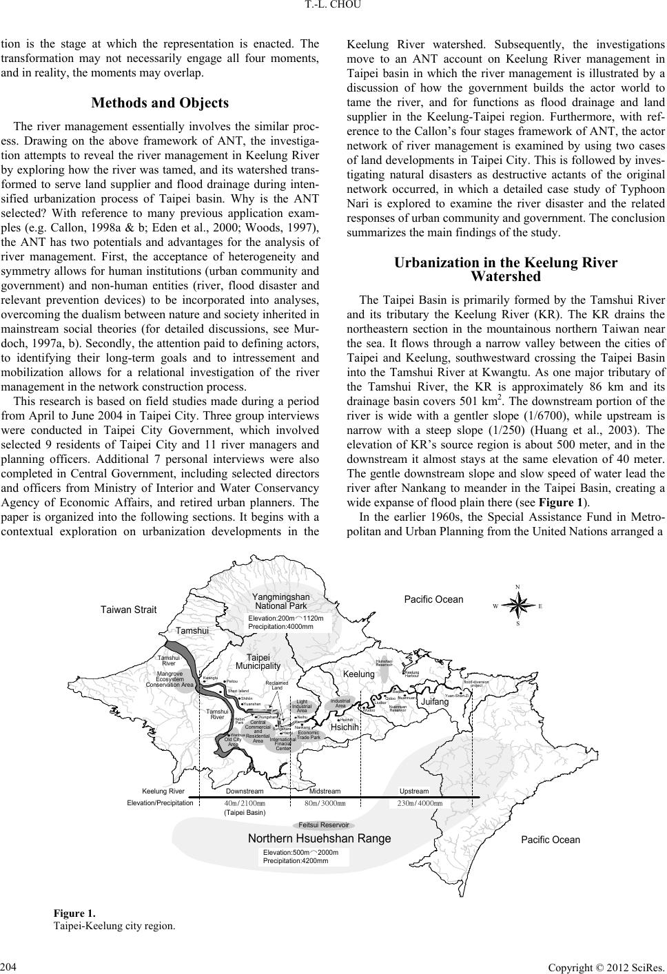 T.-L. CHOU tion is the stage at which the representation is enacted. The transformation may not necessarily engage all four moments, and in reality, the mome nts may overlap. Methods and Objects The river management essentially involves the similar proc- ess. Drawing on the above framework of ANT, the investiga- tion attempts to reveal the river management in Keelung River by exploring how the river was tamed, and its watershed trans- formed to serve land supplier and flood drainage during inten- sified urbanization process of Taipei basin. Why is the ANT selected? With reference to many previous application exam- ples (e.g. Callon, 1998a & b; Eden et al., 2000; Woods, 1997), the ANT has two potentials and advantages for the analysis of river management. First, the acceptance of heterogeneity and symmetry allows for human institutions (urban community and government) and non-human entities (river, flood disaster and relevant prevention devices) to be incorporated into analyses, overcoming the dualism between nature and society inherited in mainstream social theories (for detailed discussions, see Mur- doch, 1997a, b). Secondly, the attention paid to defining actors, to identifying their long-term goals and to intressement and mobilization allows for a relational investigation of the river management in the network construction process. This research is based on field studies made during a period from April to June 2004 in Taipei City. Three group interviews were conducted in Taipei City Government, which involved selected 9 residents of Taipei City and 11 river managers and planning officers. Additional 7 personal interviews were also completed in Central Government, including selected directors and officers from Ministry of Interior and Water Conservancy Agency of Economic Affairs, and retired urban planners. The paper is organized into the following sections. It begins with a contextual exploration on urbanization developments in the Keelung River watershed. Subsequently, the investigations move to an ANT account on Keelung River management in Taipei basin in which the river management is illustrated by a discussion of how the government builds the actor world to tame the river, and for functions as flood drainage and land supplier in the Keelung-Taipei region. Furthermore, with ref- erence to the Callon’s four stages framework of ANT, the actor network of river management is examined by using two cases of land developments in Taipei City. This is followed by inves- tigating natural disasters as destructive actants of the original network occurred, in which a detailed case study of Typhoon Nari is explored to examine the river disaster and the related responses of urban community and government. The conclu si on summarizes the main findings of the study. Urbanization in the Keelung River Watershed The Taipei Basin is primarily formed by the Tamshui River and its tributary the Keelung River (KR). The KR drains the northeastern section in the mountainous northern Taiwan near the sea. It flows through a narrow valley between the cities of Taipei and Keelung, southwestward crossing the Taipei Basin into the Tamshui River at Kwangtu. As one major tributary of the Tamshui River, the KR is approximately 86 km and its drainage basin covers 501 km2. The downstream portion of the river is wide with a gentler slope (1/6700), while upstream is narrow with a steep slope (1/250) (Huang et al., 2003). The elevation of KR’s source region is about 500 meter, and in the downstream it almost stays at the same elevation of 40 meter. The gentle downstream slope and slow speed of water lead the river after Nankang to meander in the Taipei Basin, creating a wide expanse of flood plain there (see Figure 1). In the earlier 1960s, the Special Assistance Fund in Metro- politan and Urban Planning from the United Nations arranged a Central Commercial and Residential Area Light Industrial Area Taiwan Strait N EW S Yangmingshan National Park Keelung Taipei Municipality Tamshui Hsichih Juifang Mangrove Ecosystem Conservation Area Feitsui Reservoir Industrial Area Reclaimed Land Old City Area Kwangtu Shihlin Yuanshan Hebin Park Wanhua Peitou Neihu Economic Trade Park Nankang Hsichih Wudoo LiudooQidooNuannuan Badoo International Finacial Center Nuannuan Reservoir Pacific Ocean Yuan-Shan-Zi Northern Hsuehshan Range Keelung Harbour Hsinyi flood-diversion project Elevation:500m⌒2000m Precipitation:4200mm Tamshui River DownstreamMidstreamUpstreamKeelung River Elevation/Precipitation 40m/2100mm 230m/4000mm80m/3000mm (Taipei Basin) Elevation:200m⌒1120m Precipitation:4000mm Hsinshan Reservoir Tamshui River Pacific Ocean Shezi Island Chungshan Sungshan Figure 1. Taipei-Keelung city region. Copyright © 2012 SciRe s . 204  T.-L. CHOU team of experts to conduct detailed studies on the metropolitan development in the Taipei-Keelung region, and recommended concrete programs for its future urban development (CIECD 1969b; Monson, 1964). As the director Donald Monson docu- mented in the Regional Plan of Taipei-Keelung Metropolitan in 1968, “Topography and the heavy rainfall accompanying ty- phoons to which the Taipei Basin is subjected are the ba- sic restraints which determine where urban development can take place” (UHDC, 1968: p. 5). This constraint thus led most of the earlier urban growth in the Taipei Basin to centralize in Taipei City and its contiguous suburbs primarily in the Tamshui River watershed (UHDC, 1968: pp. 19-21). Nevertheless, this does not imply that the KR watershed was free from the urbanization impacts. Owing to its location advantage adjacent to the Keelung seaport and Taipei, industrial zones in the KR watershed had emerged as a signifi- cant part of urbanization in the city region (see Figure 1). The narrow valley connecting the Keelung harbor with Taipei city, which provided level road and rail access to the Keelung City, was also urbanized. The KR watershed had experienced exten- sive industrial growth, in which industrial zones, cargo yards and thousand of factories were scattered along the river valley. Further urban development pressures towards the KR water- shed had arisen since the late 1980s, because urbanization in the Taipei Basin had reached its saturation point. The urbaniza- tion pressures thus embarked on the Basin an ambitious plan of land reclamation to create new space for industrial and urban development. As a Japanese map in 1938 shows, areas of the KR meandering across the Taipei Basin were primarily located in Neihu area and used by farmers as pasture and arable land (Taipei City Government, 1970: p. 95). By the 1990s, the me- andering waterway in the Neihu area was artificially modified into a straight river channel with embankment and 10 water pumping stations. The river length in Taipei City was drasti- cally reduced by 5.3 kilometers. More than 500 hectares of land were created and transformed into Neihu Science Park for high-tech industrial developments in Taipei. The land devel- opment project of the KR was accordingly seen as the most significant achievement for recent urban developments in Taipei (see Huang, 2001: p. 118). Moreover, Shezi Island (323 hectares) and Kwangtu (924 hectares) in the downstream flood plain have since the late 1990s faced increasing development pressures to serve as the city ’s sub-center. The urbanization process of Taipei Basin had also led to an outward spread of land developments into the fringe townships of the adjacent Taipei County especially in Hsinyi, Neihu, and Nankang districts, and resulted in population explosion in Hsi- chih by threefolds from 55,736 to 170,765 during the period from 1976 to 2003. The intensified urbanization thus resulted in dramatic land use changes in the watershed. By the year 2000, industrial zones totaling 1407 hectares had been developed in Wudoo, Nankang and Neihu to meet the manufacturing investments. The urbanized areas in the watershed amounted to 335,691 hectares, and its population reached about 3.24 million by 2003, growing from 2.56 million in 1976. As Donald Monson (1964: p. 5) has indicated, during the development of Taipei Basin in the earlier 1960s, “except where urbanization has taken place, the flat areas are intensively cultivated while the slopes and mountains are largely wooded”. However, the intensified ur- banization subsequently resulted in a dramatic change in its land cover. The forest areas had since the late 1980s been dra- matically reduced by about 78 per cents. The areas with less-than-100 m2 each were reduced by 70 percents, while the forest areas of between 100 m2 and 1 hectare decreased by 81 per cents (Whong, 2001: p. 78). The huge forest losses consid- erably increased the surface runoff, and made natural disasters inevitable in the urbanization process. The Management of Keelung River Watershed: An ANT Account ANT is not only a sociological theory but also a historically and dynamically sociological theory. Chronological order is important. As documented, the management plan of KR water- shed (involved in the Regional Plan of Taipei-Keelung Metro- politan) began in the 1960s. The policy of the flood Control Plan for Great Taipei Area was decided in 1971. Levees, chan- nels, and drainage systems were constructed in the 1970s and the 1980s. The meandering waterway KR in Neihu area was artificially modified into a straight river channel with embank- ment during the 1990s. In the process, all of human and non-human actors/actants constitute a network by the combina- tion, recombination, and destruction of relations. As such, fol- lowing account of ANT on KR management for the whole process in a historical order is divided into two subsections. The first part focuses on investigating non-human actants in the 1960s and 1970s. The analysis is done by looking at how non-human entities, especially hydraulic device, engineering and knowledge, are enrolled, mobilized and applied in the river management. The second part discusses on the story of human actors framed in Callon’s model of four stages happened in the 1980s and 1990s. The Identification of Actors and Actants (Or Identities in Action) As mentioned above, the general limits of urban develop- ment in the Taipei Basin are set by physiography and the dan- ger of flood. As the Regional Plan of Taipei-Keelung Metro- politan documented in 1968, the Taipei Basin “has a humid sub-tropical climate, with an average an- nual rainfall of 2118 mm. The rain can come in heavy down-pours whose violence is reflected in the variation of flow in the Tamshui River from an average low water flow of 38 cubic meters per second to a maximum re- corded flow of 20,050 cubic meters per second, a flow which flooded most of the basin” (UHDC, 1968: p. 5). Against this natural constraint, the Water Conservancy Agency was put in charge in July 1960 of carrying out a de- tailed survey on the hydraulic character and performance of the rivers in Taipei Basin, including the precipitation, inundation estimation, channel survey, flood history, and the effects of existing flood control facilities. A subcommittee of the Tech- nological Direction Committee, consisting of hydraulic special- ists of the Special Assistance Fund from the United Nations and the Chinese Institute of Civil and Hydraulic Engineering, was also appointed to provide professional recommendations to the survey and subsequent flood control plan. Hydraulic engineer- ing expertise especially for river channelization was brought in from overseas sources. Copyright © 2012 SciRe s . 205  T.-L. CHOU With two years’ intensive work, a significant amount of river information was collected that included geologic maps of Taipei Basin, precipitation hydrograph of Taipei city from 1900 to 1960, isohyet map of recorded maximum storm rainfall, hydrographs of the Tamshui River, the KR and its tributaries, areas subject to flood threat in the Taipei Basin and so on. Concrete policy outputs included the Yuanshanzi diversion tunnel plan, a river-mouth widening project at Kwangtu, a jetty plan at Tamshui River mouth, and so on. Tamshui and KRs in Taipei Basin were demarcated, classified, quantified, mapped out, and the records were finally filed in the Survey and Report of Flood Control Plan for Tamshui River System in 1963 (Tai- wan Province Government, 1963). All of the paper inscriptions, maps and the four policy alternatives for flood control in the Taipei Basin were submitted to the Examination Group of Taipei Flood Control Plan in the central government. Actually, the examination was carried out through two reviewing phases by the Corps of Engineers, arriving Taipei in 1964 at the re- quest of American International Development (AID). The Phase I review team visited Taipei in April 1964 and the Phase II review team was in Taipei from 5 August to 11 September 1964 (see Corps of Engineers USA, 1965: 1). According to the debates of urban development and flood control, the review teams reached the following agreements concerning the flood control plan for the Taipei Basin (see Corps of Engineers USA, 1965; Darling et al., 1964). First, channel improvements and levees are the most feasible means of obtaining a desirable degree of protection for the Taipei Basin. Secondly, engineer- ing designs for flood prevention should take the discharge of 200-year floods into consideration for this densely populated metropolitan area. Thirdly, long range plan of comprehensive flood protection for the Taipei Basin should consider changing the tributary waterway in upstream Tamshui River and widen- ing its river mouth at Kwangtu which were seen as technically feasible and economically justifiable. These recommendations were officially approved as a statu- tory plan at the end of 1964, or the Flood Control Plan for Tamshui River, which was subsequently revised as the Flood Control Plan for Great Taipei Area in 1971 (Ying, 2001: pp 22-32). Nevertheless, the hydraulic engineering plan confronted a critical opposition by a group of urban planning professionals led by Dr. Donald Monson who contented that “the conservation of the flood plains in the Taipei Basin as overflow lands shall be considered a primary flood protection measure. Lands subject to flooding shall not be urbanized except where the regional flood control system is not adversely affected and where such urbanization is economically justified” (UHDC, 1968: p. 14). He further suggests that urban development pressures in the Basin shall accommodate by establishing new towns and ex- tending existing satellite towns in the Taipei-Keelung region (ibid.). However, urban developments spread as usual through- out the Basin, in that the urban policy proposed by Dr. Monson was not seriously implemented. As an interviewee retrospect, “annual river flood disasters caused by typhoons in the 1970s indeed imposed great political pressures upon the central and city governments to carry out flood prevention project accord- ing to the Flood Control Plan” (interviewed in 2004 April). Nevertheless, implementation of the Flood Control Plan was not carried out until the 1980s when Dr. Monson had already left Taiwan. The Flood Control Plan, drawing from the Review Report, was accepted as a policy consensus, a “vision plan” for flood control, and a blueprint for the prevention of 200-year floods in the Taipei Basin. According to the plan, anticipations of the river development were mixed up with the goals for land use gains and the protection of urban communities and properties. Four important flood control measures were adopted. First, dikes and levees were commonly used to reduce flood damages. Second, dredging or channel improvements were employed to increase the conveying capacity of the river. Third, drainage systems were also constructed to reduce flood damages in ur- ban areas. A common practice for drainage improvement was to install pumping stations in low-lying areas to remove storm water. Finally, river conveyance was increased by channel re- location or meander reduction. In short, natural river processes and their analyses were presented as part of the Flood Control Plan, but they were subsequently replaced by the engineering methods of river management, especially channel improvement. As former Taipei City Mayor Lee Teng-Hui documented in 1981, “Taipei City Government has effectively carried out the flood-control measures according to the Taipei Flood Control Plan …. Under construction are the flood preven- tion projects in Shezi Island, the dike projects in the Choumei and Kwangtu areas …. and the pumping stations at Chungshan …and Yuanshan. With these city-led pro- jects and efforts, a comprehensive flood control system was thus constructed. In the next six-year plan, the city government will move to carry out a drainage system to ensure safety of city population and their properties” (Lee, 1981: p. 12). It was expected to reduce the natural forces by using the channelization engineering solutions to push water through river channels faster and then reduce flood risk in the urban areas. The channelization engineering of the river thus became the dominant mode of river management. One interviewee comments that “the government-led project did not adopt eco-based flood control strategies through preserving wetlands and floodplains, because it was harmful to the riverside land developments” (interviewed in 2004 April). It was under the land development logic that the strategies of building levees and water pumping stations had become the only solution to the annual flood threats of the KR (Taipei City Government, 1970). Costing more than US $33 billions, 50 pumping stations as well as levees, some 12-meter height and 100-kilometer long, had been completed during fourteen-year period from 1982 to 1996 in Taipei Basin. As Figure 2 shows, the major urbanized areas in the Taipei Basin had since been tightly enclosed and pro- tected by the long levees and pumping stations. The river man- agement hence represented a complex hybrid of nature and society, with the shapes, flows, and catchments of the rivers being extensively monitored and modified for urban needs. However, as an interviewee further comments, “once the levees were completed, the KR was overwhelmingly isolated from people’s daily life. The river was not only increasingly sepa- rated from the urban communities, but also modified to provide land and flood drainage for the city” (interviewed in 2004 May). Value and meaning of river to the city are hence functionally reduced to the land supply and flood drainage. Against this backdrop, the Commanding Center for Flood Control and Hydrological Information Center was also estab- lished by the Water Conservancy Agency (WCA) and filled Copyright © 2012 SciRe s . 206  T.-L. CHOU N EW S 11 Tamshui River eelung Rive eihu Science Park Shezi Isl an d Embankment Unfini shed Embankment Inundation Area Breached Points of Levees 11 Figure 2. Riverbanks, water pumping stations and Nari inundation area in Taipei city (enlargement of a central part of Figure 1). with professional staff and institutions to provide flood warning, damage notification and other information management with GIS for preventing urban communities from violent flood at- tacks. The WCA ha s thus played as the “center of ca lculation”, manipulating the Flood Control Plan as the basis for river con- trol and transformation. However, the story does not end here. One interviewee furt her indicates that “at the nationa l level, the central government has since the 1990s been pressured by the worsening natural disasters of typhoon-induced urban floods and landslides to improve river engineering, hydrologic tech- nologies, weather knowledge, and disaster relief organizations. It pumped massive budgets to purchase technologies and con- duct research on hydrology and weather prediction” (inter- viewed in 2004 April). More importantly, it has also upgraded the functional status of the Central Weather Prediction Bureau (CWPB) to Emergency Relief Center during the typhoon period, and organized the central and local governments to monitor typhoon development and carry out disaster rescues. Actually, the CWPB has functioned as another “center of calculation”, conducting various weather information collections and predic- tions using materials/technologies, and provided the analysis findings to the Relief Center for decision making. These mobi- lization and transformation processes in typhoon season then allow ‘the centre of calculation’ to speak on behalf of typhoons and the river. Against these backdrops, annual budgets of over US$ 1billion have since 1996 been mobilized by various de- partments of the government to promote the National Science & Technology Program for Hazards Mitigation (NSTPHM). The giant project aims at the production of full knowledge on natural disaster prevention through researches on meteorology, flood control, mudslide, natural hazard information collection and its protection mechanism (see Table 1). With growing urban flood threats and riverside development pressures, the government has hence imposed its hegemonic power upon the actor network of KR with the support of urban communities. Obviously, the government has built up its power through the acquisition of weather/hydrological technologies and knowledge that have enhanced the weather prediction ca- pability and the knowledge of typhoon formation, its evolution, path, wind velocity and precipitation. In other words, the gov- ernment has regarded the hydrological engineering and organi- zation as important resources to transform and tame the natural forces of river and typhoon, maintaining order within the KR network, and finally (re)producing the dominance of the gov- ernment and urban community over the network. The Translation of Keelung Rive Network: from Problematisation to Mobilization Intensified urbanization of Taipei Basin was accompanied by the river management that dominated the politics of Taipei and greatly affected the livelihood of a large number of the city’s residents. With reference to Callon’s (1986b) four stages of actor-network theory—problematisation, interessement, enrol- ment and mobilization—this section investigates two land de- velopment projects along the river on the Neihu and Shezi Is- land in Taipei City. As these two areas were subject to flooding, they were conserved as flood plains downstream. However, the Neihu project had in the late 1980s translated over 500 hectares of the riverside into the Neihu Science Park by straightening out the meandering river way. Meanwhile, the Shezi Island has since the early 1990s been scheduled by the development plan of the city government to function as a strategic satellite center of more than 180 hectares in Taipei city. By using the case studies of Callon (1986b ) and Wo ods (19 97) as a model, I hope my case studies of urban development on the Neihu and Shezi Island (see Figure 1) will contribute to a bet- ter understanding of the processes of river management that involve both human (urban community and government) and non-human (river, flood disasters and prevention devices) ac- tor-networks and that dominate Taipei’s urban politics. Problematization At the heart of river management during the urbanization process is the relation between a group of human actors (in the city government, central government and local community) and the definitions and interests which the human actors ascribe to themselves and non-human actants (river, flood disasters and prevention devices). In Taipei City, the human actors have identified an urban development problem, which is that the river and flood disasters are perceived to be a city threat, and the actors have attempted to resolve the problem through the coupled devices of an urban development plan and a river flood prevention project. In addition, the identification of the problem is dependent on a particular definition of the river and disasters, and the interests of the actors. Fundamentally, they define the river as an area whose primary functions is flood drainage for the city during typhoon season, and whose flood plain awaits urban development (see Taipei City Government, 1982). The flood disaster is defined as a natural phenomenon, but a Copyright © 2012 SciRe s . 207  T.-L. CHOU Copyright © 2012 SciRe s . 208 Table 1. National science & technology program for hazards mitigation, 1999-2001. 1999 2000 US$ millions Project numbersUS$ millions Project num bers 2001 US$ millions Ministry of the Interior (Bureau for Fire Protection) .4 5 .49 5 .35 Ministry of the Interior (Construction and Pl anning Administration) .18 4 - - .33 Ministry of the Interi o r (Institute of Architecture) 7.3 10 .3 9 19.0 Ministry of Transportation and Communic ation (Central Weather Prediction Bureau) 2.4 16 .96 17 .63 Ministry of Economic Affairs (Water Conservancy Agency) 1.9 10 2.17 6 2.67 Ministry of Economic Affairs (Institu te of Geo- graphical Information Survey) .52 3 2.0 2 .67 Ministry of Finance (Insurance Administration) - - - - .1 Executive Yuan (Public Engineer ing Council) .32 3 .57 6 .6 Executive Yuan (Agricultural Development Council) .57 2 - - 1.67 Ministry of Education (Consultant Office) .12 15 .12 18 .1 Health Administratio n .15 2 .61 16 .13 Environme nt Administration .3 1 .05 1 .07 National Science Council 2.64 129 2.9 125 3.44 total 7.19 200 10.2 205 11.53 Source: based on NAPHM Newsletter 2000(2): 36. destructive threat to city development and has to bring under control. Flood drainage and land supply are identified as the primary interest of the city to the KR However, the city gov- ernment views the river itself as incapable of realizing this in- terest. The government therefore defines itself as representing the river’s interest by the coupled devices of urban develop- ment plan (UDP) and flood prevention project (FPP). However, the city government could not actually have the full authority to pursue these devices alone. Rather, it recog- nized that power could only be mobilized by enrolling the cen- tral government which has the final authority to make decisions on the master urban development plan of the capital and flood prevention project proposed by the city government, and which, through its budgetary and hydraulic engineering supports, would be able activate a network of flood prevention devices. The passing of the above UDP and FPP is hence positioned as an obligatory passage point (OPP) for the objective of urban development, realizing through the mobilization of all human actors and non-human actants in river management network (see Figure 3). Figure 3. River development ne t wo rk. OPP = obligatory passage point. stage involved compatible inter-group definitions of the fol- lowing five sets of entities by the city government, each of which would need to be enrolled into an actor-network if the plan and project for the river development were to be successful. These entities ar e: As one interviewee suggests, “the primary interests of the central and city governments in the river management are served by gaining legitimacy as the dual tasks of flood draining and land supply are enforced to facilitate the public interests of urban development, and to realize the citizen protections from flood threats” (interviewed in 2004 April). Consequently, an- other major activity of city government has been to seek public support from local communities (especially residents and landowner groups) to carry out the coupled UDP and FPP. At this point, the city government may be identified as the initiator of the coupled plan and project. As such, the problematisation 1) The river—defined as above. 2) Flood disasters—defined as undesired threats to city development and must be brought under control. 3) Flood prevention devices—defined as useful mate- rial weapons to protect the c it y from flood threats. 4) City government—defined as having the power to  T.-L. CHOU carry out the coupled strategy that bundle UDP with FPP. The city government sees itself as following the local wishes of accelerating urban development and protecting citizen life an d property. 5) Central government—defined as the “representa tive” of the river, the gatekeeper of the controversial river- side urban development plan, and as a resource base for fiscal budget and hydraulic engineering for the flood prevention project. 6) Local community—defined as residents and land- owners in Neihu, Shezi and Hsichih districts who are able to urge governments to facilitate the coupled UDP and FPP especially after river flood disasters in the ty- phoon season. 7) Other local population—defined as other citizens in great Taipei area who wish to live in a safe city without river flood threat. Interessement The interessement of some of the above entities is straight- forward and pursues without dispute. The other local popula- tion does not dispute the definition or interest ascribed to them. As a newly industrialized country, Taiwan was so wedded to the capitalist development process that the political culture of environmental opposition was still at the infant stage in the 1980s. As such, the other population (the public) normally kept silent towards the riverside land development projects in urban Taiwan. The river has no means to dissent. For the human ac- tors—city government, central government and local commu- nity—it involved linking the issue of flood disasters to wider discourses of urban development, in order to persuade them that river flood has to be suppressed on political and economic grounds. Against this backdrop, flood prevention was contextualized within wider discourses of urban development, suggesting that the flood disaster violates the legitimacy of the city and central governments to create a safe haven for local communities, and it was an obstacle to the right of urban citizens to elevate wel- fare through urban land developments. As such, the coupled devices of UDP and FPP discursively became the two sides of a coin for rive management as the urbanization intensified. As the former mayor of Taipei City, Xu Shu-Der (1985-1988) docu- mented, “enforcement of the Neihu development project would not only reduce flood threats of Eastern Taipei, but also create a new residential and economic space for l20,000 people and related industrial developments during the city transformation process. The Neihu project is a win-win- win project for the city, government and society” (Huang, 2001: p. 118). The coupled device is consequently identified as being in the interest of the above three human actors in the KR watershed. Through this interessement, the definition of the primary enti- ties in the network was secured and a river management net- work between the three major human actors formed. Enrolment The river was hence enrolled without discussion or negotia- tion through the devices of the flood prevention. As far as the Neihu case was concerned, a report on the detailed hydrographs of the KR was completed by the National Taiwan University in 1983, which concluded that “the meandering areas of KR in Neihu can be reclaimed to meet the local requirement of urban development if the river waterway can be kept at the width of 350 meters, because this would not increase the river-water level too much.” (Yet, 1983: p. 40). The conclusion was further confirmed by a hydraulic simula- tion experiment of the WCA, which was done at request of and paid for by the central government. Armed with scientific technologies, flood prevention devices are fully mobilized and constructed by the end of 1980s for the city protection. With these state supports, the city government thus in 1986 submit- ted the Neihu development project to the central government. Besides, the development plan of Shezi Island was initiated in 1993 by the city government. Based on flood prevention con- siderations, low-density development became the primary pol- icy for the island plan. However, as one interviewee points out, “the plan was suspended because of ferocious confrontations of local community in Shezi that wished to have giant capital gains through a high-density development plan for the island” (interviewed in 2004 May). In 1996, the city government was forced to widen the river channel and use landfill to raise is- land’s elevation by 6 - 9 meters to prevent flooding for the is- land. Subsequently, a high-density development plan was pro- posed to translate the island from a flood plain into a satellite center of Taipei city (Taipei City Government, 2002). The de- velopment plan was subsequently approved in 2002 by the central government. There were about 12,000 people living on the Shezi Island in the late 1990s, while the riverside in Neihu was occupied by 13,000 residents and numerous factories in the late 1980s. They were hence fully enrolled into the networks by a generous offer of city government in high-density benefits of land development. As such, the local communities were in turn enrolled into powerful supporters for the coupled UDP and FPP. Mobilization Mobilization of the network obviously also depends on a full support of the central government of the coupled UDP and FPP to develop the riverside areas. In fact, the submitted flood pre- vention project in the Neihu case encountered difficulty during the reviewing process of WCA in 1986 due to the resistance of hydraulic experts who were concerned about flood hazards. However, a serious flood disaster of the KR caused by Typhoon Lynn in 1987 (see Table 2) became a legitimacy challenge to the central government led by Lee Teng-Hui (1987-1999), who had served as mayor of Taipei City during the period of 1978- 1981. The disaster caused by Lynn typhoon especially imposed a dramatic political pressure upon the central government to reconsider the Neihu project proposed by the city government. Subsequently, President Lee arranged a series of private meet- ings with his cabinet members and politically pushed through the coupled UDP and FPP agenda in Neihu (Ying, 2001: p. 38). It was during this political process that the worried voices of the hydraulic experts were suppressed and ultimately disap- peared. The coupled UDP and FPP were approved with a minor Copyright © 2012 SciRe s . 209  T.-L. CHOU modification in 1988. Similar mobilization process also happened in the case of the Shezi Island especially after typhoon attacks. In fact, the cou- pled device of flood prevention project and high-density de- velopment plan was announced by Mayor Chen Sui-Ben under the community pressure of a serious flood disaster caused by Typhoon Herb in 1996. In the mayoral election of the same year, the proposal of island development was subsequently adopted as a strategic propaganda by his political competitor (Ma Yin-Joe) in order to gain the support of the Shezi Island community. As Mayor Ma came to power after the election, the Shezi Island is subsequently scheduled for development by the city government. Nevertheless, the submitted flood prevention project has not been approved by the WCA until 2010, although the urban development plan has been approved. The reason for its delayed approval, as one interviewee suggests, “is neither because the Shezi Island was functionally designed as flood plain, nor because the flood prevention project was regarded improper by the WCA. Instead, the Shezi development will expose the central government to fierce political criticisms from the neighboring urban communities of Taipei County, because the island development project will significantly put them in further flood threat” (interviewed in 2004 May). Nevertheless, the Shezi project finally gains the central supports when Ma win the 2008 presidential election, and was politically approved in 2010. The river management is obviously occurred in a chrono- logical order, involving to tame the whole KR Watershed by a long term effort of human actor group to facilitate the urban development and bring the river under control. The river man- agement process is discerned in Callon’s sequence of four mo- ments as above. In problemization, human actors (urban com- munity and governments) and non-human actants (the river, flood disaster and prevention devices) are defined and their interests are described in Nehhu and Shezi cases. The urban communities constantly enjoy their material benefits in the ur- banized area. The government reinforces its legitimacy by testing its flood control plan and the KR continually exists and evolves with the urbanization development in the watershed. The rela- tionships in this framework are then tested through intresse- ment, which refers to the river development tactics by which the government attempt to impose and stabilize the identities of the KR. The tactics is organized to mobilize the flood pre- vention devices, ranging from river channelization engineer- ing to the improvement of weather technology . Subsequent ly, the entities are pushed into the river network through a series of transactions in which the actors and actants must behave in the ways which they have been assigned. The role of the river is seen as a land supplier and for flood drainage through the flood control plan. The government is enrolled through pre- paring a nd implementi ng the plan. At this stag e of the proce ss of forming the network of river modification, urban commu- nities and residents are enrolled as powerful supporters. However, some of them are not actors but audiences, waiting for final results. When the above entities are involved, mobi- lization could then be achieved, with all actors organized into a networ k designed to ach ieve the gover nment’s desir ed goals. This realization process thus helped turn the river into a man- ageable entity and made the governmental apparatus the piv- otal centre of river management focused on a series of flood control plans. Disasters as Destructive Actants of the Original Network As Murdoch (1997b: p. 741) argues, ‘network building is a precarious process: the alliances in the network can be con- tested at any moment’. In the KR case, it is found that the gov- ernment-led strategy of river development and control using scientific engineering and knowledge was not wholly effective in forcing the river and related non-human actants under the network to play the functional role set by the government. In- stead, internal tensions within the river taming network had been deepened as dramatic climate changes accelerated re- cently. On average, the tropical weather in the West Pacific Region generates 27 typhoons annually, three to four of which affect Taiwan (Cheng, 2000: p. 13). With frequent powerful typhoons, the KR had repeatedly caused destructive disasters, leading to river crises in Taipei’s urbanized areas. As Table 2 shows, the river disasters have become more frequent with worsening ef- fects in recent ye ar s . Hsichih was inundated with almost every typhoon, because of its overdevelopment and the lack of investments in flood mitigation infrastructures. In 1997, Typhoon Winny caused the flooded areas to go up to 141 hectares. Moreover, 200 house- holds of Lincoln Mansion in Hsichih were destroyed in massive mudslides that buried 28 people alive. Subsequently, in 1998 Typhoons Zeb and Babs submerged the city in stormwater twice in two weeks, inundating about 300 hectares and causing three deaths. In response to this disaster, the 10th River Basin Management Bureau of WCA launched a further flood control project with a budget of US $348.5 millions for Hsichih in 1998, which was completed in 2000 (WCA, 2000: p. 17). Ty- phoons Toraji and Nari ravaged Taiwan in 2001, claiming 185 deaths with more than 100 people missing islandwide. Hsichih Table 2. Floods of KR in selected typhoons. Inundation depth (met ers)Raining hours Influenced cities Inundation (hectares) Lynn (1987.10.24) 3.0 48 Hsichih, Taipei 609.6 Herb (1996.7.31) 3.0 24 Major cities i n Taipei Basin- Winny (1997.8.18) .2 - 0.3 7 - 24 Hsichih, Taipei 141.1 Anb (1997.8.29) .2 - 1.0 10 - 15 Hsichih, Taipei 197 Zeb (1998.10.15) .5 - 4.0 10 - 16 Hsichih 291 Babs (1998.10.26) .5 - 3.8 5 - 8 Hsichih 286 Xangsane (2000.11.1) .5 - 7.5 10 - 16 Hsichih, Keelung 441 Toraji (2001.7.30) - - Hsichih 800 Nari (2001.9.16-18) 1.5 - 8.5 16 Hsichih, Taipei, Keelung 800 Copyright © 2012 SciRe s . 210  T.-L. CHOU was again submerged twice and broke its record in areas sub- merged. The natural disaster in these two typhoons almost du- plicated the river disasters occurred before. This shows that the government-led costly projects of flood control cannot com- pletely shield the urbanized areas from serious flooding. The river and flood disasters had not played their roles as expected and controlled by the government strategies. In particular, Ty- phoon Nari of 2001 has played as a destructive actant of origi- nal network constructed by the UDP and FPP, and leads a new network and a new translation to rise after the disaster. Being one of the deadliest typhoons, Nari wreaked havoc mainly on northern Taiwan. It broke many records in Taiwan’s weather history, including precipitation in a single-day as well as the longest period for a typhoon to linger over the island which was more than 48 hours. Nari dropped in Taipei, Hsichih and Keelung 425 millimeters, 881 millimeters, and 900 milli- meters of rainfall, respectively. Taipei city area received 800 millimeters of rainfall in a single day on 17 November, about one third of the annual precipitation in Taipei. On the same day, mountainous areas in northern Taiwan received over 1000 mil- limeters of rainfall. Rainwater is more dangerous than violent gusts in Taiwan because many urban communities are located on slopelands subject to debris and landslide threats. The rain- fall and path of Nari Typhoon was beyond the technological capability of the government to predict (China Times 2001/9/ 18). Its record-breaking precipitation in major urbanized areas resulted in serious disasters. 800 hectares were submerged and 60 people died in the Nari disaster. In fact, the KR is firmly walled by long embankments as well as 50 pumping stations, among which the Yucheng pump- ing station was claimed to be the largest in Southeast Asia. However, since Typhoon Nari had brought too much stormwa- ter, the highest water level in Hsichih reaches 15.4 m that ex- ceeded the embankment height of 12 m (Shiu, 2001). In Taipei City, the river spilled from the embankment at lower positions (about 9 meter height), and leaked from its breaches. It subse- quently submerged almost half of the pumping stations, and resulted in a severe river disaster in Taipei city (see Figure 2 for the breaching points). Owing to the failure of pumping sta- tions, Nari’s floodwater not only submerged Keelung, Taipei and Hsichih cities, but also rushed into underground tunnels of the Mass Rapid Transit (MRT) and destroyed its central control system. It cost more than US $150 million in losses and seri- ously affected Taipei’s traffics for a month. The flood control projects of US $3 billion suffered a crushing defeat in the Nari disaster. The heartland of Taipei Basin was, although highly protected, seriously submerged in water. In Taipei County, not just Hsichih was submerged as usual, Juifang and Pingsi in the upstream were also inundated up to the second floor. Nari again smashed the government-led flood control projects in 2001. As one interviewee comments, “the natural forces of typhoon and river had inflicted so much damage to peoples’ lives and properties that severe criticisms in Taiwan’s newspapers and electronic media went on for more than three months. The Nari flood was not only described as a natural disaster but also em- phasized as a man-made catastrophe” (interviewed in 2004 May). Various in-depth reports and discussions in the media argued that the natural disaster was made worse by improper land use regulations in the watershed, uncompleted investments in the flood prevention infrastructure, and governmental mis- management in the disaster rescue process (United Daily News 2001/10/1-3). The media pressure thus translated the river dis- aster into a fierce political storm targeted at the central and local government. It is condemned by one interviewee that “Taipei city government was in mismanagements of the river and thus must take full responsibility to compensate for the losses of lives and properties in the river disaster” (interviewed in 2004 May). The political repercussions finally forced Mayor Mar Yin-Jeo to make an apology in the City Parliament. Sub- sequently, the Control Yuan filed an investigation, also charg- ing him with mismanagement. In September 2002, an investi- gation bill was passed by the Legislative Yuan requiring the city government to upgrade the river engineering infrastructure and reinforce its administrative capability to carry out natural disaster relief. As the river crisis intensified into political controversies in Taipei, the Executive Yuan ordered the WCA to improve the 200-year flood defense policy and to raise the height of the river embankment, with the designed capacity of embankment for peak river discharge increased from 3600 tons to 5200 tons per second. Moreover, a self-help civilian organization was also initiated by the residents of Hsichih who resorted to a street demonstration demanding the central government to accelerate the KR flood control project. Above all, Liao Shei-Kwan, a member of the Legislative Yuan and former mayor of Hsichih, proposed a special law for the KR flood control to reinforce flood mitigation infrastructure and disaster prevention engi- neering in Taipei County. He tactically boycotted the important bills of Taiwan’s WTO entrance and connected national eco- nomic restructuring projects as a political weapon to push through the special law on the KR in the Legislative Yuan. The central government was accordingly forced to further spend huge amounts of money on channel engineering for flood con- trol. Combined with a growing political pressure of the coming general election, the special law was enacted in 2002, and a large budget was also swiftly passed for embankment construc- tion and flood diversion. Four flood control programs were quickly launched to bring the KR under control after the Nari. The entire project costing about US $3 billion aims to 1) con- struct a flood control dam in upstream Pingsi; 2) facilitate the embankment construction program in the Taipei-Keelung re- gion; 3) carry out flood-diversion projects at Yuanshanzi and Badoo areas; and 4) complete the flood diversion tunnel at Yuanshanzi to intercept floodwater upstream and guide it to the Pacific Ocean directly, which was originally proposed by the Survey and Report of Flood Control Plan for Tamshui River System in 1963 (Taiwan Province, 1963: 47). It is estimated that such projects would reduce the water level of KR by 1.5 m. The above four strategies that constitute the Comprehensive Plan of Flood Control for the KR is completed in 2008. As one interviewee concludes, “the river crisis has further driven the government to intensify its efforts to bring the KR under con- trol by reinforcing the hydraulic engineering. The city govern- ment, urban residents and other actors repeatedly attempted to institutionalize the river management under the notion of ‘man over nature, while resorting to more engineering techniques to suppress and control the KR’” (interviewed in 2004 June). This development has hence led the KR transformation into a new stage of translation of original network, in which existing rela- tions are destructed and recombined to further mobilize the non-human actants for flood prevention devices. Concluding Remarks With reference to the actor network theory, this paper has at- Copyright © 2012 SciRe s . 211  T.-L. CHOU tempted to explore river management in urban Taiwan by ex- amining the historical transformation processes of KR in Taipei Basin. It is suggested that urbanization developments in Taipei Basin has increasingly formulated the governments and urban communities into dominant actors in the actor network of the KR. During the development process, they have intensified network construction in an attempt to gain privileges of repre- sentation, to speak for the river and flood disaster, and to im- pose land supply and flood drainage as the functions for the river. In building this network, the government paired UDP with FPP as a strategy to develop the river’s floodplains. The river course was changed to make land available for urban de- velopment. In response to the intensive riverside land develop- ment and in order to avoid river flood threats, the government has played a central role, constantly pumping monetary re- sources to mobilize various scientific knowledge and technol- ogy in the weather prediction and flood control engineering to transform the river and disasters. In the spiraling interaction between city and river disasters within the network, the ‘man over nature’ idea was constantly facilitated as an engineering conviction to further tame the river. In the process, all of human and non-human actors/actants constitute a network by combina- tion, recombination, and destruction of relations. The river management is obviously not produced solely by natural nor social processes. Instead, they are a hybrid of the processes of social, technical and natural change, of decades of urbanization, land development and flood defense. However, during the river management process, the contradictions and conflicts between the river disaster, government and urban community are inten- sified as the river is extensively transformed to meet the de- mand of urbanization. The Nari disaster has played as destruc- tive actantto the orginal network constructed by the UDP and FPP, and lead to a further transformation of the river wate rshed. As Latour (1994: p. 32) argues, transformation is “displacement, difference, invention, mediation, the creation of a link that did not exist before and that to some degree modifies two elements or agents”. It is a mutual and interactive change among hetero- geneous elements, guided neither by determinism (technologi- cal, social, or environmental) nor (evoluti onary) progress shaped by any powerful individuals or structures (Callon, 1991; Labour, 1987; Eden et al., 2000). The river can still challenge the city. In fact, the city of Hsichih was seriously inundated again by Typhoon Haima in September 2004. The above discussions suggest that the actor network theory is a useful framework providing an alternative view on nature and man as actors in man-land relationship. This is primarily because of its distinctive ability to incorporate non-human ac- tors on the same basis as humans, which cannot be realized in conventional social theories (Murdoch, 1997a, b). Nevertheless, the ANT also faces considerable limits. A significant limitation of ANT relates to its impartiality rule that requires the analysts to be as undecided as the actors they follow. According to La- tour (1991: p. 130), “we refuse to accept judgments that tran- scend the situation”. According to Eden, Tunstall and Tapsell (2000), this implies that the analyst can only look backwards to what has happened and not what might happen, because the contingent character of transformation makes it unpredictable. The analyst cannot judge the outcome of the process. This thus causes Winner (1993: p. 368) to complain about its “disdain for anything resembling an evaluative stance or any particular moral or political principles”. In a nutshell, the ANT “becomes empty when asked to provide policy, pass judgment or explain stable feature” (Latour, 1996: p. 304). Eden, Tunstall and Tapsell (2000) further take all these together to conclude that the ANT is less helpful in evaluating the environmental policy. Therefore, the ANT is theoretically unable to come up with any future policy recommendations for flood control in the KR watershed. Nevertheless, what is clear is that engineering pro- jects to river management cannot be implemented effectively without considering the policies governing land use change in a watershed such as the KR where unpredictable hydrologic ex- tremes can occur under the unfavorable physiographic and geologic conditions of the watershed. REFERENCES Burgess, J., Clark, J., & Harrison, C. M. (2000). Knowledge in action: An actor network analysis of a wetland argi-environment scheme. Ecological Economics , 35, 119-132. doi:10.1016/S0921-8009(00)00172-5 Callon, M. (1986a). The sociology of an actor-network: The case of the electric vehicle. In M. Callon, J. Law, & A. Rip (Eds.), Mapping the dynamics of science and technology (pp. 19-34). London: Macmillan Press. Callon, M. (1986b). Some elements of a sociology of translation: Do- mestication of the scallops and fishmen of St. Brieuc Bay. In J. Law (Ed.), Power, action and belief: A new sociology of knowledge (pp. 196-233). London: Routledge and Kegan Paul. Callon, M. (1987). Society in the making: The study of technology as a tool for sociological analysis. In T. Huges, & T. Pinch (Eds.), The social construction of technological systems: New directions in the sociology and history of technology (pp. 83-103). London: MIT Press. Callon, M. (1991). Techno-economic networks and irreversibility. In J. Law (Ed.), A sociology of monsters (pp. 132-161). London: Routledge. Callon, M., Law, J., & Rip, A. (1986). Mapping the dynamics of sci- ence and technology. Basingstoke: Macmillan. Chen, K. S., Wang, J. T., & Mitnik, L. M. (2001). Satellite and ground observations of the evolution of Typhoon Herb near Taiwan. Remote Sensing of Environme nt, 75, 397-411. doi:10.1016/S0034-4257(00)00182-6 Cheng, J. D., Lin, L. L., & Lu, H. S. (2002). Influences of forests on water flows from headwater watersheds in Taiwan. Forest Ecology and Management, 165, 11-28. doi:10.1016/S0378-1127(01)00626-0 Cheng, L.-F. (2000). Typhoons in this year. NAPHM Newsletter, 2, 13-16 (in Chinese). CIECD (Council for International Economic Cooperation and Devel- opment) (1969). Working reports of urban construction and housing planning. Taipei: International Economic Corporation and Develop- ment Council. Comber, A., Fisher, P., & Wadsworth, R. (2003). Actor-network theory: A suitable framework to understand how land cover mapping pro- jects develop? Land Use Policy, 20, 299-309. doi:10.1016/S0264-8377(03)00048-6 Corps of Engineers USA (1965). Report on review of Taipei area flood control planning phase II. Taichung: Water Conservancy Agency, Taiwan Province. Darling, W. D., & Buswell, J. M. (1964). Preliminary review of flood protection plan for Tam-shui river, Taipei Plain, Taiwan. Taichung: Water Conservanc y Agency, Taiwan Pro v i n c e . Eden, S., Tunstall, S. M., & Tsapsell, S. M. (2000). Translating nature: River restoration as nature-culture. Environment and Planning D, 18, 257-273. doi:10.1068/d180257 Hsu, M.-H., Fu, J.-C., & Liu, W.-C. (2003). Flood routing with real- time stage correction method for flash flood forecasting in the Tanshui River, Taiwan. Journal of Hydrology, 2 83 , 267-280. doi:10.1016/S0022-1694(03)00274-9 Huang F.-S. (2001). Oral history of Taipei Municipality by mayors and councilors. Taipei: Taipei City Council (in Chinese) . Huang, K.-M., & Lin, S. (2003). Consequences and implication of Copyright © 2012 SciRe s . 212  T.-L. CHOU Copyright © 2012 SciRe s . 213 heavy metal spatial variations in sediments of the KR drainage basin, Taiwan. Chemosphere, 53, 1113-1121. doi:10.1016/S0045-6535(03)00592-7 Kelman, A. (2003) A river and its city. Berkeley, CA: University of California Press. Kortelainen, J. (1999). The river as an actor-network: The Finnish forest industry utilization of lake and river systems. Geoforum, 30, 235-247. doi:10.1016/S0016-7185(99)00019-6 Latour, B. (1996). Social theory and the study of computerized work sites. In W. J. Orkilowske, G. Walsham, M. R. Jones, & J. I. DeGross (Eds.), Information technology and changes in organiza- tional work. London: Chapman and Hall. Latour, B. (1991). Technology I society make durable. In J. Law (Ed.), A sociology of monsters. London: R o ut l e d g e a n d K e g a n P a ul . Latour, B. (1987). Science in Action: How to follow scientists and en- gineers through society. Milton Keynes: Open University Press. Latour, B. (1986). The power of association. In J. Law (Ed.), Power, action belief: A new sociolog y of knowledge? London: Ro utledge and Kegan Paul. Law, J. (1991). Sociology of monsters. London: Routledge. Lee T.-H. (1981). Development plan for Taipei City. Taipei: Taipei City Government. Lo, S. L., Kuo, J. T., & Wang, S. M. (1996). Water quality monitoring network design of KR, northern Taiwan. Water Science and Tech- nology, 34, 49-57. doi:10.1016/S0273-1223(96)00853-0 Lu, S.-Y., Cheng, J. D., & Brooks, K. N. (2001). Managing forests for watershed protections in Taiwan. Forest Ecology and Management, 143, 77-85. doi:10.1016/S0378-1127(00)00507-7 Monson, D. (1964). Special fund assistance to the Republic of China for regional and urban planning and housing in Taiwan. Taipei: UNTAB. Murdoch, J. (1995). Actor-networks and the evolution of economic forms: combining description and explanation in theories of regula- tion, flexible specialization and networks. Environment and Planning A, 27, 731-757. doi:10.1068/a270731 Murdoch, J. (1997a). Towards a geography of heterogeneous associa- tions. Progress in H uman Geography, 21, 321-337. doi:10.1191/030913297668007261 Murdoch, J. (1997b). Inhuman/nonhuman/human: Actor-network the- ory and the prospects for a nondualistic and symmetrical perspective on nature and society. Environment and Plann i n g D , 15, 731-756. doi:10.1068/d150731 Murdoch, J. (1998). The spaces of actor-network theory. Geoforum, 29, 357-374. doi:10.1016/S0016-7185(98)00011-6 Murdoch, J. (2001). Ecologising sociology: Actor-network theory, co- construction and the problems of human exemptionalism. Sociology, 35, 111-133. doi:10.1017/S0038038501000074 Pfadenhauer, J. (2001). Some remarks on the socio-cultural background of restoration ecology. Restoration Ecolo g y, 9, 220-229. doi:10.1046/j.1526-100x.2001.009002220.x Ryan, R. T. (1998). Local perceptions and values for a Midwestern river corridor. Landscape and Urban Planning, 42, 225-237. doi:10.1016/S0169-2046(98)00089-9 Shiu, K.-L. (2001). A special report on Nari Typhoon. Taipei: United News, 18 September 2001. Taipei City Government (2002). Master plan for Shezi island develop- ment. Taipei: City Development Bureau. Taipei City Government (1982). Taipei city master plan. Taipei: City Construction Bureau. Taipei City Government (1970). A brief history of Taipei urban devel- opment. Taipei: Archives Councils Press (in Chinese) . Taiwan Province Government (1963). Survey and report of flood con- trol plan for Tamshui River system. Taichung: Water Resources Management Bureau, Taiwan Province (in Chinese). UHDC (Urban and Hosuing Development Committee) (1968). Taipei- Keelung metropolitan regional plan. Taipei: UHDC. Van Diggelen, R., Grootjans, Ab. P., & Harris, J. A. (2001). Ecological restoration: Government of the art or government of science? Resto- ration Ecology, 9, 115-118. doi:10.1046/j.1526-100x.2001.009002115.x Water Conservancy Agency (2000). Profile of water conservancy agency, ministry of economic affairs: Man and water—Mutually de- pendent. Taipei: Water Conservancy Agency. Whong, Y.-L. (2001). Watershed planning based on the management of ecological system: A case study on KR. Taipei: Master dissertation of Graduate Institute of Resource Management, National Taipei Uni- versity (in Chinese). Woods, M. (1997). Researching rural conflicts: Hunting, local politics and actor-networks. Journal of Rural Studies, 14, 321-340. doi:10.1016/S0743-0167(97)00038-7 Yet, C.-L. (1983). A hydrographic studies on KR. Taipei: Taiwan Uni- versity (in Chinese). Ying, W.-Z. (2001). Flowing hope/disaster: Political economy of KR flood control project. Master Dissertation of Graduate Institute of Building and Planning Institute, National Taiwan University (in Chinese).
|