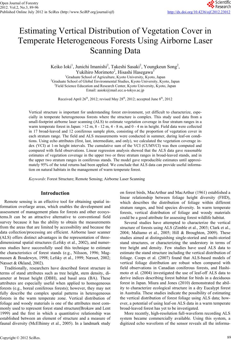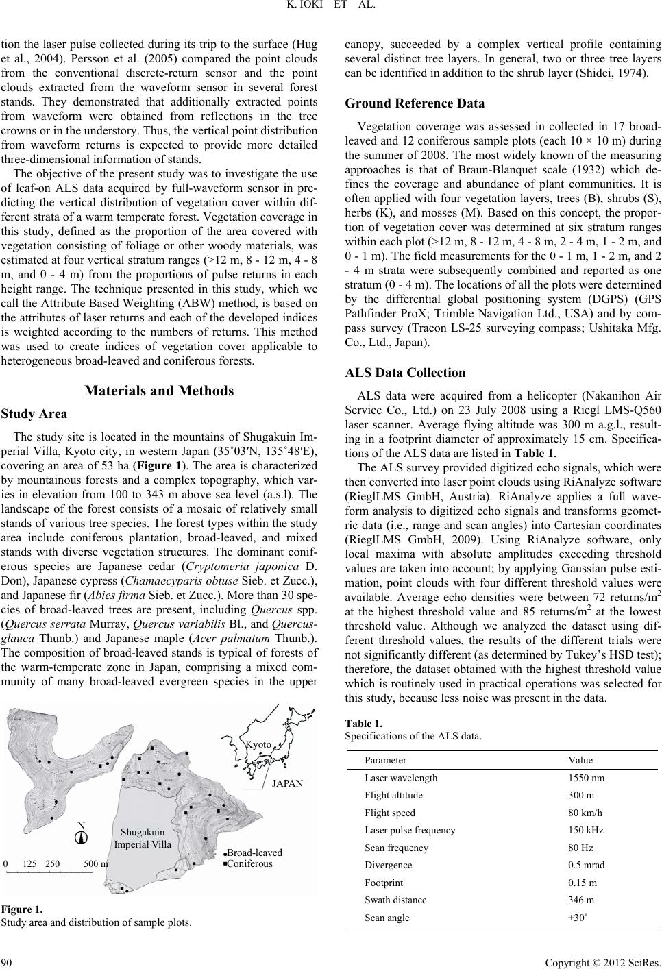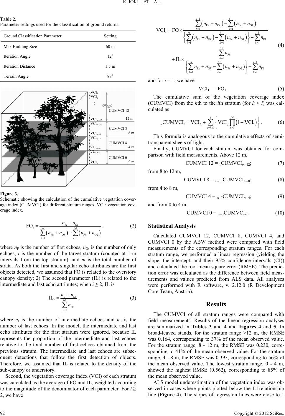
K. IOKI ET AL.
Copyright © 2012 SciRes.
96
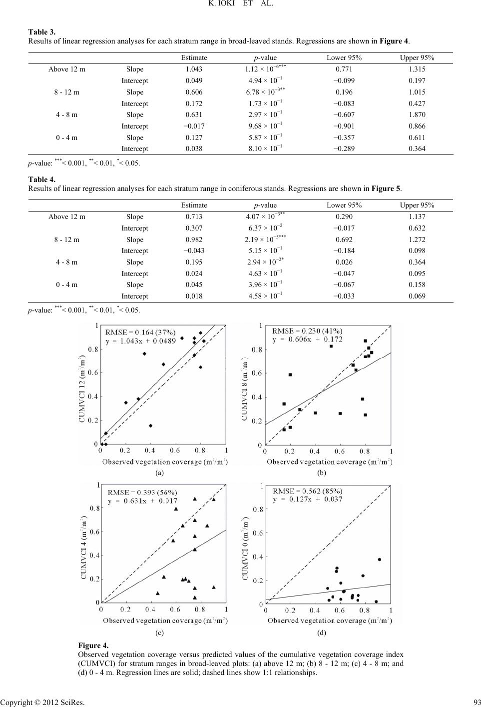
95% of the total number of ALS returns had been incorporated
into the model. The results in this study show that the presented
method can be used for estimating the vertical distribution of
vegetation cover in the upper two or three stratum ranges in
broad-leaved stands, and in the upper two stratum ranges in
coniferous stands.Although CUMVCI was calculated for four
stratum ranges in this study, the approach can accommodate
different numbers of stratum ranges.Future research should
examine the applicability of the model to different forest types.
Acknowledgements
The authors wish to thank the Organization for Landscape
and Urban Green Technology Department, Japan for financial
support. We are also grateful to the Imperial Household Agency,
Kyoto Office, for assistance with ALS data acquisition and
field observations.
REFERENCES
Axelsson, P.E. (2000). DEM generation from laser scanner data using
adaptive TIN models. International Archives of the Photogrammetry
and Remote Sensing, 33, 110-117.
Braun-Blanquet, J. (1932). Plant sociology: The study of plant commu-
nities (English translation). New York: McGraw-Hill.
Brokaw, N. V. L., & Lent, R. A. (1999). Vertical structure. In I. Hunter,
& L. Malcom (Eds.), Maintaining biodiversity in forest ecosystems
(pp. 373-399). Cambridge: Cambridge University Press.
doi:10.1017/CBO9780511613029.013
Clark, M. L., Clark, D. B., & Roberts, D. A. (2004). Small-footprint
lidar estimation of sub-canopy elevation and tree height in a tropical
rain forest landscape. Remote Sensing of Environment, 91, 68-89.
doi:10.1016/j.rse.2004.02.008
Coops, N. C., Hilker, T., Wulder, M. A., St-Onge, B., Newnham, G.,
Siggins, A., & Trofymow, J. A. (2007). Estimating canopy structure
of Douglas-Fir forest stands from discrete-return LiDAR. Trees, 21,
295-310. doi:10.1007/s00468-006-0119-6
Gaveau, D. L. A., & Hill, R. A. (2003). Quantifying canopy height
underestimation by laser pulse penetration in small-footprint airborne
laser scanning data. Canadian Journal of Remote Sensing, 29, 650-
657. doi:10.5589/m03-023
Lefsky, M. A., Cohen, W. B., Acker, S. A., Parker, G. G., Spies, T. A.,
& Harding, D. (1999). Lidar remote sensing of the canopy structure
and biophysical properties of Douglas-Fir Western Hemlock Forests.
Remote Sensing of Environment, 70, 339-361.
doi:10.1016/S0034-4257(99)00052-8
Hashimoto, H., Imanishi, J., Hagiwara, A., Morimoto, Y., & Kitada, K.
(2004). Estimating forest structure indices for evaluation of forest
bird habitats by an airborne laser scanner. In M. Thies, B. Koch, H.
Spiecker, & H. Weinacker (Eds.), Laser scanners for forest and
land- scape assessment: Proceedings of the ISPRS Working Group
VIII/2, Freiburg, 3-6 October 2004, 254-258.
Hill, R. A., & Broughton, R. K. (2009). Mapping the understory of de-
ciduous woodland from leaf-on and leaf-off airborne LiDAR data: A
case study in lowland Britain. ISPRS Journal of Photogrammetry
and Remote Sensing, 64, 223-233.
doi:10.1016/j.isprsjprs.2008.12.004
Holmgren, J., & Persson, Å. (2004). Identifying species of individual
trees using airborne laser scanner. Remote Sensing of Environment,
90, 415-423. doi:10.1016/S0034-4257(03)00140-8
Hug, C., Ullrich, A., & Grimm, A. (2004). LITEMAPPER-5600: A wave-
form-digitizinglidar terrain and vegetation mapping system. Remote
Sensing and Spatial Information Sciences, 36, 24-29.
MacArthur, R. H., & MacArthur, J. W. (1961). On bird species diver-
sity. Ecology, 42, 594-598. doi:10.2307/1932254
Magnussen, S., & Boudewyn, P. (1998). Derivations of stand heights
from airborne laser scanner data with canopy-based quantile estima-
tors. Canadian Journal of Forest Research, 28, 1016-1031.
doi:10.1139/x98-078
Maltamo, M., Packalén, P., Yu, X., Eerikäinen, K., Hyyppä, J., & Pit-
känen, J. (2005). Identifying and quantifying structural characteris-
tics of heterogeneous boreal forests using laser scanner data. Forest
Ecology and Management, 216, 41-50.
doi:10.1016/j.foreco.2005.05.034
McElhinny, C., Gibbons, P., Brack, C., & Bauhus, J. (2005). Forest and
woodland stand structural complexity: Its definition and measure-
ment. Forest Ecology and Management, 218, 1-24.
doi:10.1016/j.foreco.2005.08.034
Miura, N., & Jones, S. D. (2010). Characterizing forest ecological struc-
ture using pulse types and heights of airborne laser scanning. Remote
Sensing of Environment, 11 4, 1069-1076.
doi:10.1016/j.rse.2009.12.017
Moffiet, T., Mengersen, K., Witte, C., King, R., & Denham, R. (2005).
Airborne laser scanning: Exploratory data analysis indicates potential
variables for classification of individual trees or forest stands ac-
cording to species. ISPRS Journal of Photogrammetry and Remote
Sensing, 59, 289-309. doi:10.1016/j.isprsjprs.2005.05.002
Nelson, R. (1997). Modelingforest canopy heights: The effects of can-
opy shape. Remote Sensing of Environment, 60, 327-334.
doi:10.1016/S0034-4257(96)00214-3
Nilsson, M. (1996). Estimation of tree weights and stand volume using
anairborne lidar system. Remote Sensing of Environment, 56, 1-7.
doi:10.1016/0034-4257(95)00224-3
Næsset, E. (2002). Predicting forest stand characteristics with airborne
scanning laser using a practical two-stage procedure and field data.
Remote Sensing of Environment, 80, 88-99.
doi:10.1016/S0034-4257(01)00290-5
Næsset, E. (2004). Practical large-scale forest stand inventory using a
small-footprint airborne scanning laser. Scandinavian Journal of
Forest Research, 19, 164-179. doi:10.1080/02827580310019257
Næsset, E., & Økland, T. (2002). Estimating tree height and tree crown-
properties using airborne scanning laser in a boreal nature reserve.
Remote Sensing of Environment, 79, 105-115.
doi:10.1016/S0034-4257(01)00243-7
Persson, Å., Söderman, U., Töpel, J., & Ahiberg, S. (2005). Visualiza-
tion and analysis of full-waveform airborne laser scanner data. Pro-
ceedings of ISPRS Workshop on Laser Scanning 2005, Enschede, 12-
14 September 2005, 103-108.
R Development Core Team (2010). R: A language and environment
forstatistical computing. Vienna: R Foundation for Statistical Com-
puting.
RIEGL LMS GmbH (2009). Full Waveform Analysis Software RiANA-
LYZE for RIEGL Airborne Laser Scanners LMS-Q560 and LMS-
Q680.
Shidei, T. (1974). Forest vegetation zones. In M. Numata (Eds.), The
flora and vegetation of Japan (pp. 87-124). Tokyo/Amsterdam: Ko-
dansha/Elsevier Scientific Publishing Company.
Soininen, A. (2003). Terra Scan User’s Guide.
Zimble, D. A., Evans, D. L., Carlson, G. C., Parker, R. C., Grado, S. C.,
& Gerard, P. D. (2003). Characterizing vertical forest structure using
small-footprint airborne LIDAR. Remote Sensing of Environment, 87,
171-182. doi:10.1016/S0034-4257(03)00139-1