Paper Menu >>
Journal Menu >>
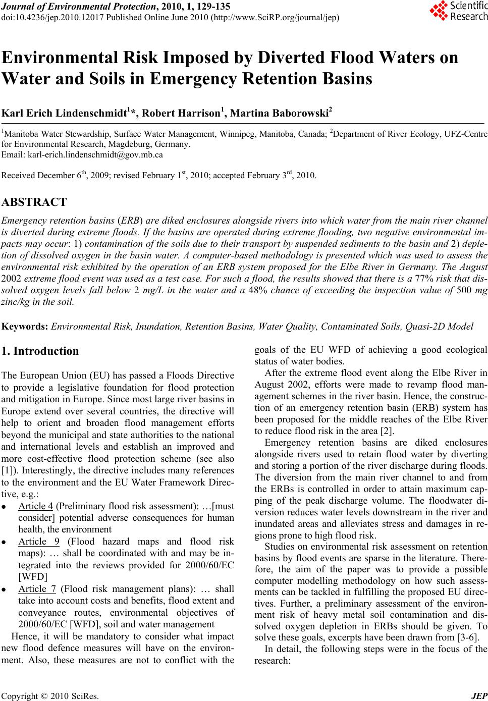 Journal of Environmental Protection, 2010, 1, 129-135 doi:10.4236/jep.2010.12017 Published Online June 2010 (http://www.SciRP.org/journal/jep) Copyright © 2010 SciRes. JEP 1 Environmental Risk Imposed by Diverted Flood Waters on Water and Soils in Emergency Retention Basins Karl Erich Lindenschmidt1*, Robert Harrison1, Martina Baborowski2 1Manitoba Water Stewardship, Surface Water Management, Winnipeg, Manitoba, Canada; 2Department of River Ecology , UFZ-Centre for Environmental Research, Magdeburg, Germany. Email: karl-erich.lindenschmidt@gov.mb.ca Received December 6th, 2009; revised February 1st, 2010; accepted February 3rd, 2010. ABSTRACT Emergency retentio n basins (ERB) are diked enclosures alongside rivers into which water from the main river channel is diverted during extreme floods. If the basins are operated during extreme flooding, two negative environmental im- pacts may occur: 1) contamination of the soils due to their transport by suspended sediments to the basin and 2) deple- tion of dissolved oxygen in the basin water. A computer-based methodology is presented which was used to assess the environmental risk exhibited by the operation of an ERB system proposed for the Elbe River in Germany. The August 2002 extreme flood event was used as a test case. For such a flood, the results showed that there is a 77% risk that dis- solved oxygen levels fall below 2 mg/L in the water and a 48% chance of exceeding the inspection value of 500 mg zinc/kg in the soil. Keywords: Environmental Risk, Inundation, Retention Basins, Water Quality, Contaminated So ils, Quasi-2D Model 1. Introduction The European Union (EU) has passed a Floods Directive to provide a legislative foundation for flood protection and mitigation in Europe. Since most large river basins in Europe extend over several countries, the directive will help to orient and broaden flood management efforts beyond the municipal and state au thorities to the nation al and international levels and establish an improved and more cost-effective flood protection scheme (see also [1]). Interestingly, the directive includes many references to the environment and the EU Water Framework Direc- tive, e.g.: Article 4 (Preliminary flood risk assessment): …[must consider] potential adverse consequences for human health, the environment Article 9 (Flood hazard maps and flood risk maps): … shall be coordinated with and may be in- tegrated into the reviews provided for 2000/60/EC [WFD] Article 7 (Flood risk management plans): … shall take into account costs and benefits, flood extent and conveyance routes, environmental objectives of 2000/60/EC [WFD], soil and water management Hence, it will be mandatory to consider what impact new flood defence measures will have on the environ- ment. Also, these measures are not to conflict with the goals of the EU WFD of achieving a good ecological status of wa t er bodies. After the extreme flood event along the Elbe River in August 2002, efforts were made to revamp flood man- agement schemes in the river basin. Hence, the construc- tion of an emergency retention basin (ERB) system has been proposed for the middle reaches of the Elbe River to reduce flood risk in the area [2]. Emergency retention basins are diked enclosures alongside rivers used to retain flood water by diverting and storing a por tion of the r iver disch arge during floods. The diversion from the main river channel to and from the ERBs is controlled in order to attain maximum cap- ping of the peak discharge volume. The floodwater di- version reduces water levels downstream in the river and inundated areas and alleviates stress and damages in re- gions prone to high flood risk. Studies on environmental risk assessment on retention basins by flood events are sparse in the literatu re. There- fore, the aim of the paper was to provide a possible computer modelling methodology on how such assess- ments can be tackled in fulfilling the proposed EU direc- tives. Further, a preliminary assessment of the environ- ment risk of heavy metal soil contamination and dis- solved oxygen depletion in ERBs should be given. To solve these goals, excerpts have been drawn from [3-6]. In detail, the following steps were in the focus of the research:  Environmental Risk Imposed by Diverted Flood Waters on Water and Soils in Emergency Retention Basins Copyright © 2010 SciRes. JEP 130 develop and test a quasi-2D (two-dimension) model in which the equations of motion and continuity are calculated in 1D (one-dimension) but the discretisa- tion scheme allows for a 2D representation of flow and substance distribution; this minimises comput- ing and pre-processing expenditure without com- pensating spatial diff erentiation of flood behaviou r, test how effective the proposed ERB system is able to cap the peak discharge of the hydrograph from the August 2002 flood, investigate the environmental risk of heavy-metal contamination of ERB soils after flood water reten- tion, and assess the environmental risk of dissolved oxygen depletion in the water retained in the basins. 2. Study Area Two ERBs were investigated in this studie, P1 and P3 (see Figure 1). They are situated between Torgau and Wittenberg. Morphological characteristics of the ERBs are given in Table 1. Several gates are to control the flow of water through the ERBs: an inlet gate at the southernmost tip of P1, an outlet gate at the westernmost point of P3 by Pretzsch and a connecting gate between P1 and P3. Table 1. Morphological characteristics of emergency reten- tion basins P1 and P3 Po lderSur face ar eaVolumeHeadDepth (km 2 )(10 6 m 3 )(m.a.s.l.) (m) P1 24.5 85 77.53.3 P38.22075.3 2.3 Figure 1. Investigated emergency retention basins (ERB) proposed for the Elbe River reach between Torgau and Wittenberg, modified from [2] 3. Modeling Tool and Setup The hydrodynamic module DYNHYD (based on St. Ve- nant equations), the sediment and contaminant transport module TOXI and the water-quality module EUTRO from the WASP5 (Water quality Analysis Simulation Program v.5) modelling package, developed by the U.S. Environmental Protection Agency [7] was used for the floodwater simulations. Figure 2 (left panel) shows the discretisation of the river-ERB system domain in junc- tions and channels. The junctions ensure volume conti- nuity, hence all junction water volumes represent the total water volume in the system. The channels are the basis for computing the flow in 1D between the junctions. Many channels may branch from a junction allowing the discretisation to take a 2D characterisation. The segment discretisation for the contaminant transport and wa- ter-quality model, shown in Figure 2 (right panel), cor- responds 1-to-1 the junction discretisation. In TOXI, processes that describe the transport and fate of heavy-metal contaminants include: longitudinal dispersion in the water column, vertical diffusion of dissolved substances between the water column and the bottom sediments, sedimentation of suspended solids, re-suspension of solids from the bottom sediments to the water column, and sorption of dissolved substances to suspended and deposited sediments. EUTRO was used to simulate water quality pertaining to the oxygen balance in a river and ERBs using the cy- cles of dissolved oxygen (DO) decomposition and nutri- ent-limited phytoplankton growth. Oxygen is also con- sumed in the sediments, which is described in the model by the sediment oxygen demand. An important source of oxygen into the water body is re-aeration via the water surface from the atmosphere. An important source and sink of DO are phytoplank- ton photosynthesis and respiration, respectively. Phyto- plankton growth is also light limited and its loss rate is governed by respiration, death, settling and zooplankton grazing. The DYNHYD, EUTRO and TOXI modules were structured in a simulation platform HLA (High Level Architecture) to allow Monte-Carlo analyses (MOCA) to be carried out [8]. The MOCA allowed uncertainty bounds to be computed in order to assess the degree of risk in exceeding environmental thresholds. For the en- vironmental risk appraisal the following were investi- gated: 1) the amount of zinc, with high contamination potential along the Elbe [9], sorbed and deposited from the diverted flood waters and 2) the minimum concentra- tion of DO attained in the basin waters. 4. Results For a comprehensive description of the development,  Environmental Risk Imposed by Diverted Flood Waters on Water and Soils in Emergency Retention Basins Copyright © 2010 SciRes. JEP 131 Figure 2. Discretisation for the hydrodynamic model with junctions and channels (left panel) and the water-quality model with segments (right panel), modified from [6] and [5] 01234567891011 Simulation da y 72 73 74 75 76 77 78 79 Wate r level (m.a.s.l.) river (no polders) river (with polders) north polder (P3) south polder (P1) G F E D C B A Figure 3. Left panel: water levels in the river and ERBs during operation. Right panel: flow velocity field in the ERBs during filling (longest vector length corresponds to 1.2 m/s), adapted from [6] calibration and validation of the models with corre- sponding sensitivity analyses of the parameters and boundary conditions, the reader is referred to [6] for the hydrodynamic modelling, [4] for contaminant transport modelling and [5] for the eutrophication modelling. Only the key results to support the environmental assessments will be presented here. 4.1 Hydrodynamics Figure 3 (left panel) shows the water level hydrographs of the August 2002 flood simulated along the river at Positions A, B and C (see Figure 2 for spatial reference). The dashed line of the hydrograph crests represent water level heights that occurred without the ERB system, the solid line represents the lowering of the water levels that can be obtained wh en the ERBs are included in the mod- elling. The capping lies in the range of 35 to 40 cm and progressively recedes as the flood wave moves down- stream (compare Position C). This is due to flood wave attenuation and widening of the floodplain downstream from Pretzsch towards Wittenberg (see Figure 1). Fig- ure 3 (right panel) shows the 2D spatial differentiation of the flow field. Details on the development, calibration and validation of the model and the optimisation of the control of ERB filling are given in [4] and [6]. 4.2 Soil Contamination Figure 4 (left panel) shows the results of zinc concentra- tions in the river and ERBs. The initial concentrations in the ERB segments on the onset of water inflow corre- spond to the con centrations in th e water in the immediate upstream-lying segments. Once the ERBs are filled and the flood gates are closed (approximately after Day 6 for P3 and after Day 7 for P1), there is a substantial drop in substance concentrations in the ERB water column due to sedimentation of suspended sediment. Up to 90% of Time = 5.25  Environmental Risk Imposed by Diverted Flood Waters on Water and Soils in Emergency Retention Basins Copyright © 2010 SciRes. JEP 132 012345678910 Simulation Day 0 10 20 30 40 50 60 70 Total zinc ( g/L) Figure 4. Total zinc (left panel) in the river at Position A (see Figure 2) and in ERBs P1 and P3. Zinc concentration (mg/kg) in bottom sediments during flood water retention [4] 024681012 Simulation day 2 4 6 8 10 mg O 2 /L P1 inlet P1 extremity P3 river Wittenberg saturation max_ 5 min_ 0 DO (mg O2/L) Figure 5. Left panel: DO concentrations in the river and ERBs during floodwater diversion. Right panel: lower 10% quartile of minimum DO at each segment throughout the ERB system [5] the sediment settles out of the water column to the bot- tom sediments. Figure 4 (right panel) shows the spatial distribution of particulate zinc concentrations in the bot- tom sediments representing zinc deposition during the retention stage of flood water diversion. Particulate zinc is deposited quite quickly when water enters P1. Much of the particulate matter has also been trapped in P1 before the water enters P3. During flood water retention, zinc concentrations are even ly distributed thro ughou t th e ERB bottom sediments. 4.3 Dissolved Oxygen Depletion Figure 5 (left panel) shows the DO simulations in the river at Wittenberg and in the ERBs. The DO levels in the river remain substantially below saturation levels. Upon entering the ERBs, diverted flood water receives more oxygen from the hydraulic re-aeration when pass- ing through the inlet gates. The initial flow of shallow waters during basin filling (Day 4 to 7) also contributes to the input of oxygen into the water. There is a progres- sive decline in DO concentrations during flood water retention (Days 8 and 9) which progresses into the emp- tying phase (after Day 9). The lower decile of the minimum DO concentrations is shown spatially in Figure 5 (right panel). The DO lev- els are higher in P3 than in P1. The extremity (eastern bay) of P1 is generally less oxygenated than the remain- ing water in the ERB. It should be emphasised that the August 2002 simulation represents a best-case scenario. Additional factors that may impact DO negatively but were not included in the model are 1) higher sediment oxygen demand if surfaces are arable lands and not grasslands and 2) an oxia in the water-soil interface caus- ing re-dissolution of inorganic nutrients from the ERB max=155 min=155 FRAME = 216 Da y( FRAME ) = 9  Environmental Risk Imposed by Diverted Flood Waters on Water and Soils in Emergency Retention Basins Copyright © 2010 SciRes. JEP 133 soils. 5. Environmental Risk Assessment 5.1 Soil Contamination In order to make an environmental risk assessment of contamination in the ERBs, the deposition of pollutants onto the ERB surfaces must be placed within the legal context of the German sewage sludge ordinance. An example is given here using zinc as the heavy-metal contaminant. The ordinance provides threshold values of zinc content allowed in the soils and sediment (“sludge”) deposited onto the land surfaces within the basins (sum- marised in Table 2). In accordance to the German Sewage Sludge Ordi- nance, the background zinc concentrations in the soils, where the ERBs are to be situated, must be determined. The geogenic value of 150 mg zinc/kg sediment [10] for the Elbe catchment is used here for illustration. This value does not exceed the maximum allowable zinc con- tent in the soils of 200 mg/kg. Hence, sediment may be deposited from the river water diverted into the ERBs during extreme flooding. The content of zinc within the deposited sediment may not exceed 2500 mg/kg, if the land surfaces are to continue to be used for agricultural purposes. Table 3 summarises the results from the MOCA showing that the probability of reaching this value is minute (< 1%). A different approach based on standards provided by the German Soil Protection and Contaminated Sites Ordinance is given in [5]. An important question that arises is how many flood- ings of the ERB can occur before the concentrations in the soil increase from the geog enic level of 150 mg/kg to the threshold value of 200 mg/kg. Figure 4 (right panel) shows a spatial distribution of zinc bound to deposited sediment, which corresponds to an 8% exceedence probability extracted from the MOCA. The zinc content in the soil increases by 5 mg/kg. Hence, approximately ten ERB floodings may cause zinc accumulation to reach the threshold value of 200 mg/kg. Although the environmental risk for zinc contamina- tion is low, it should be noted that an amendment to the sewage sludge ordinance is currently being discussed in which the threshold values for allowed zinc content in soils and deposited sediment (“sludge”) are lower (see Table 2). Careful measurements of the background zinc levels in the soils of the ERB sites should be carried out to determine how close these values are to the maximum allowable content in soils. The environmental risk analyses presented here shows that there is minimal risk of plant contamination by zinc deposited onto the ERBs during floods. However, the risk may be substantially increased if the ERBs are lo- cated further downstream. Figure 6 shows the zinc con- tent in deposited sediment along the portion of the Elbe River in Germany. Imbedded in the graph are the results Table 2. Threshold values of zinc content in soils and deposited sediment (“sludge”) as given by the German ordinances for sewage sludge mg zinc / kg sediment Comment Sewage sludge ordinance max. content in soil allowed 200soils with high clay content max. content in sediment allowed 2500soils with high clay content Proposed amendments to the sewage sludge ordinance max. content in soil allowed 150for loamy soils max. content in sediment allowed 1500 Table 3. Summary of the MOCA giving the probability of certain values of zinc in deposited sediments exceeding 50%, 16% and 1% in ERBs P1 and P3 50% 16%1% ( )≈( )≈( ) P1mg/kg 4606421000 P3mg/kg510 626 858 - mean; - standard deviation Exceedence probability Polder Units  Environmental Risk Imposed by Diverted Flood Waters on Water and Soils in Emergency Retention Basins Copyright © 2010 SciRes. JEP 134 Z n c o n t e n t ( m g / k g ) Elbe-km downstream from Mulde upstream from Mulde MOCA results flow direction Saale Mulde 0200500 400300600100 0 200 400 600 800 1000 1200 1400 1600 Figure 6. Longitudinal profile of zinc loading on soils along the Elbe River measured in 2003 after the extreme flood in the previous year, modified from [11], p. 242 obtained from the MOCA, the range of which complies with the range of all measurements taken upstream from the Mulde River inflow. For the river stretch downstream from the Mulde and Saale tributaries, the range and the maximum of zinc content in deposited sediments is twice as high as for the upstream reach. 5.2 Dissolved Oxygen Depletion From the MOCA runs, probability distributions of the lowest DO levels attained in the ERBs during the simula- tion time frame were derived. The cumulative frequency distributions for three locations in the ERB system are shown in Figure 7. The threshold value of the minimum concentration of DO in inland waters used for a risk as- sessment is 3 mg O2/L—the minimum oxygen content with which most fish in the Elbe River can endure for a short term [12]. As soon as the oxygen content sinks be- low approximately 3 mg/L, the fish begin to search for water pockets with better oxygen supply or begin to snap for air at the water surface [13]. For a summer time extreme flood such as the August 012345 0 0.2 0.4 0.6 0.8 1 P1 inlet P1 extremity P3 DO (mg O2/L) cumulative frequency Figure 7. Cumulative frequency distributions of the lowest dissolved oxygen concentrations attained in the ERBs 2002 event along the Elbe, the probability of the DO values dropping below a threshold value of 3 mg O2/L is quite high, 77% for the inlet region of P1, 65% for the far eastern point of the P1 extremity and 54% for P3 (see Figure 7). In general, the DO concentrations are higher more frequently in P3 than in P1 due to the shorter resi- dence times of the water in this ERB and allowing less time for de-oxygenation of the water. The generally higher DO content in P3 is also due to its sh allower depth, making it a more favourable aquatic environment for phytoplankton growth. The low DO values are also a result of low re-aeration (wind calm period) and high nitrification. In contrast to experiences gained from the Havel River during the August 2002 flood, the low oxygenated water emptying into the River Elbe does not appear to have negative implications to the oxygen levels in the river water. Although the water of the Elbe River was under Figure 8. Dissolved oxygen concentrations at Wittenberg, Magdeburg, Schnackenburg and Bunthaus (last three locations ≈ 105, 260 and 390 km downstream from Wittenberg) during the August 2002 flood of the Elbe River, adapted from [13] (mg O2/L)  Environmental Risk Imposed by Diverted Flood Waters on Water and Soils in Emergency Retention Basins Copyright © 2010 SciRes. JEP 135 the DO saturation level, DO was still above the threshold value of 3 mg/l at Wittenberg (see Figure 8). However, if these ERBs were situated further down- stream where the DO concentrations of the river water fall below the threshold value, the emptied basin water could reduce the DO concentrations further and further stress the aquatic ecosystem. 6. Conclusions The quasi-2D approach was successful in simulating the spatial distribution of flow and substance deposition in ERBs and determining the effectiveness of discharge capping. The environmental risk to heavy-metal con- tamination is minimal but may increase due to stricter threshold values. Risk may also be higher for ERBs con- structed further downstream past the Saale and Mulde river confluences where exposure to contamination is higher. There is a high potential for DO levels in the wa- ter retained in the basins to drop to very critical levels (< 3 mg O2/L), even after 4 days of flood water retention. From an ecological perspective, the basins should also be emptied as soon as possible after the flood in order to reduce the time of de-oxygenation of the water. REFERENCES [1] K.-E. Lindenschmidt, F. Hattermann, V. Mohaupt, B. Merz, Z. W. Kundzewicz and A. Bronstert, “Large-Scale Hydrological Modelling and the Water Framework Direc- tive and Floods Directive of the European Union,” Advances in Geosciences, Vol. 11, 2007, pp. 1-6. [2] IWK, “Untersuchung von Hochwasserretentions maßnah- men entlang der Elbe im Bereich der Landkreis Witten- berg und Anhalt-Zerbst” (Kurzfassung), Institute für Wa- sserbau und Kulturtechnik, Universität Karlsruhe, 2004. [3] K.-E. Lindenschmidt, “Quasi-2D Approach in Modelling the Transport of Contaminated Sediments in Floodplains during River Flooding-Model Coupling and Uncertainty Analysis,” Environmental Engineering Science, Vol. 25, No. 3, 2008, pp. 333-352. [4] K.-E. Lindenschmidt, S. Huang and M. Baborowski, “A Quasi-2D Flood Modelling Approach to Simulate Substance Transport in ERB Systems for Environmental Flood Risk Assessment,” Science of the Total Environ- ment, Vol. 397, No. 1-3, 2008, pp. 86-102. [5] K.-E., Lindenschmidt, I. Pech and M. Baborowski, “Environmental Risk of Dissolved Oxygen Depletion of Diverted Flood Waters in River ERB Systems—A Quasi- 2D Flood Modelling Approach,” Science of the Total Environment, Vol. 407, No. 5, 2009, pp. 1598-1612. [6] S. Huang, J. Rauberg, H. Apel, M. Disse and K.-E. Lindenschmidt, “The Effectiveness of ERB Systems on Peak Discharge Capping of Floods along the Middle Reaches of the Elbe River in Germany,” Hydrology and Earth System Sciences, Vol. 11, 2007, pp. 1391-1401. [7] R. B. Ambrose, T. A. Wool and J. L. Martin, “The Water Quality Simulation Program,” Water Quality Analysis Simulation Program v.5, U.S. Environmental Protec- tion Agency, Athens, GA, 1993. [8] K.-E. Lindenschmidt, J. Rauberg and F. Hesser, “Extend- ing Uncertainty Analysis of a Hydrodynamic—Water Quality Modeling System Using High Level Architec- ture,” Water Quality Research Journal of Canada, Vol. 40, No. 1, 2005, pp. 59-70. [9] M. Baborowski, W. von Tümpling and K. Friese, “Beha- viour of Suspended Particulate Matter and Selected Trace Metals during the 2002 Summer Flood in the River Elbe at Magdeburg Monitoring Station,” Hydrology and Earth System Sciences, Vol. 8, No. 2, 2004, pp. 135-150. [10] F. Krüger, A. Prange, E. Jantzen, K. Trejtnar and G. Miehlich, “Geogene Hintergrundwerte,” Wasserwirts-chaft- Wassertechnik, Vol. 7, 1998, pp.16-19. [11] W. Geller, K. Ockenfeld, M. Böhme and A. Knöchel (Eds.) “Schadstoffbelastung nach dem Elbe-Hochwasser 2002,” 2004, p. 460. [12] ARGE-Elbe, “Gewässergütebericht der Elbe 2004,” Arbeitsgemeinschaft für die Reinhaltung der Elbe, 2005, p. 6. [13] M. Böhme, F. Krüger, K. Ocken feld and W. Geller, “Scha- dstoffbelastung nach dem Elbe-Hochwasser 2002,” 2005, p. 69. |