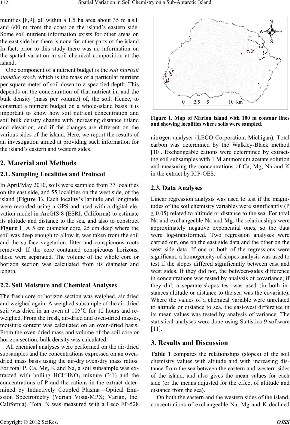
Spatial Variation in Soil Chemistry on a Sub-Antarctic Island
114
Most samples on the western side were of the coastal
plain soils; sampling did not extend as far inland or as
high up as it did on the eastern side. There was thus not
the same strong gradation from organic to mineral soils
with increasing distance inland as there was on the east-
ern side. This accounts for the lack of a significant rela-
tionship of total C, total N and bulk density with altitude
or distance to the sea on the western side.
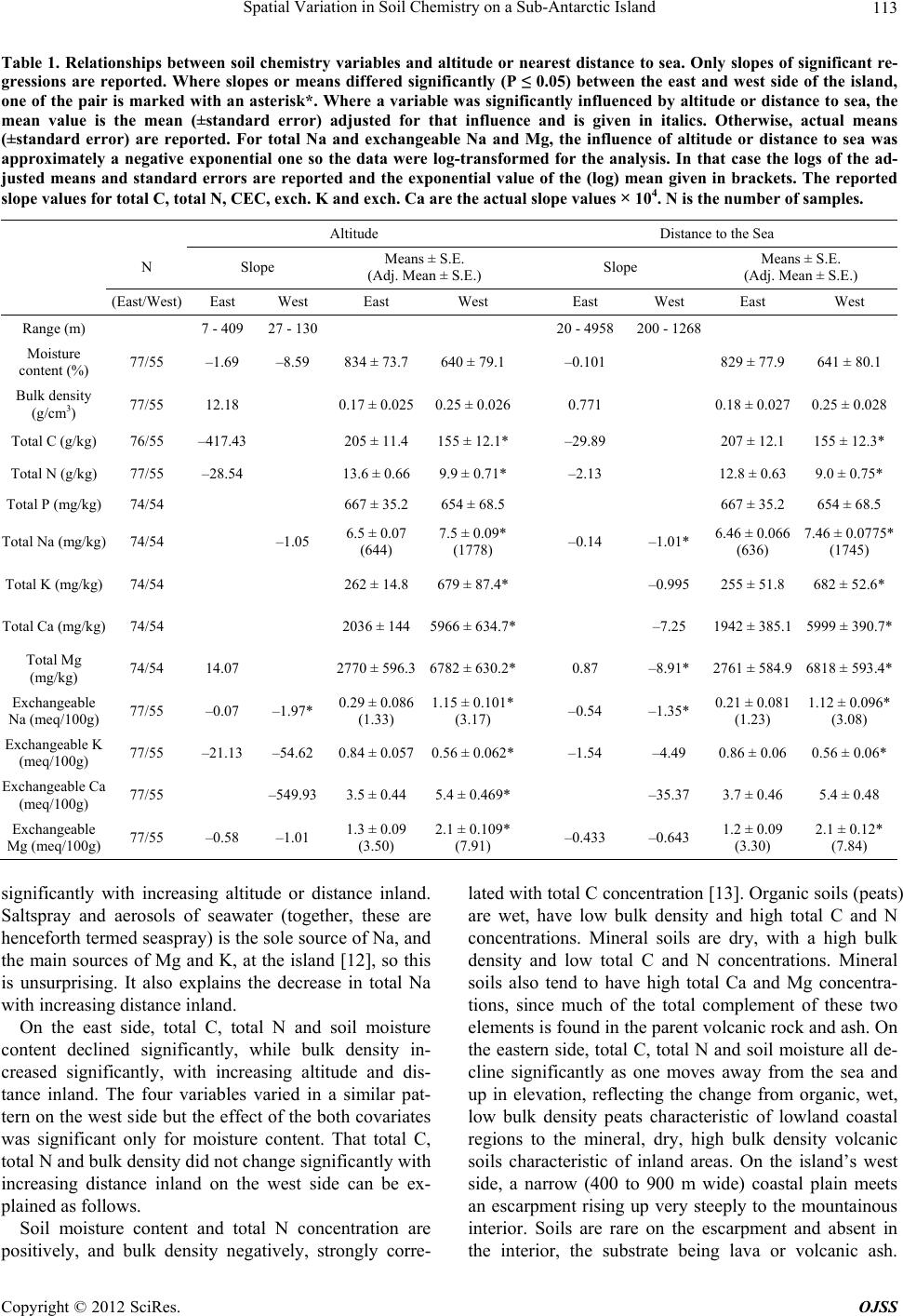
On the eastern side, total Mg concentration increased
significantly, whereas on the western side it decreased
significantly, with increasing distance from the sea. This
is also attributable to the fact that on the west the sam-
pling did not extend over as a wide range of organic ver-
sus mineral soil types as on the east coast. Most total Mg
is in the mineral fraction of the soil (the basaltic parent
lava and scoria). The organic, exchangeable and dis-
solved forms contribute little to total Mg, except perhaps
in peats close to the sea. On the east side, the gradual
transition from highly organic peats to very mineral soils
represented by the samples results in an increase in total
Mg with increasing distance inland. On the west side
there was not this range of soil minerality and the change
(decrease) in total Mg with increasing distance inland
reflects the decreasing intensity of seaspray. This is not
to say that west side soils are not more mineral, on the
whole, than east side soils—it is the change in minerality
that is important, and that is greater on the east side.
West side soils are actually intrinsically more mineral
than east side soils, as is shown by the significantly lower
total C concentrations of the west side soils when ad-
justed for the effect of altitude or distance from the sea.
Mineral soils have a higher bulk density and are drier
than organic soils, and the altitude- or distance to sea-
adjusted differences in bulk density and moisture content
between the west and east sides of the island, although
not significant at P ≤ 0.05, also point toward west side
soils being intrinsically more mineral and less organic
than the east side soils.
Because of their greater minerality, west side soils
have higher concentrations of total Ca, Mg and K than
east side soils. Because the wind (especially strong wind)
is predominantly westerly, west side soils also have
higher concentrations of total Na and exchangeable
forms of Na, Ca, and Mg than do east side soils. In con-
trast, soil exchangeable K concentrations are lower on
the west side than the on east side. The reason for this is
uncertain. K does possess cation exchange properties not
shown by the other exchangeable cations; an important
one is that it can convert from an easily exchangeable to
a fixed form in some types of clay [14]. The identities of
clay minerals in Marion Island soils are a matter of some
controversy [3]; indeed, most of the controversy con-
cerns whether there are any clays at all [15]. However,
recent Raman spectroscopic analysis reveals that crystal-
line minerals such as biotite and muscovite, both capable
of weathering into K-fixing clays, are common on the
island [16]. Possibly, K-fixation is more intense in the
mineral-rich west coast soils than in the organic east
coast ones. Another possible explanation for the lower
exchangeable K concentration in the west side than east
side soils is that the high amount of Na reaching the soil
surface through seaspray on the western side displaces
exchangeable K as it percolates through the soil. On the
east coast, replacement of K by Na on the cation ex-
change complex would be much less intense because of
the much less intense deposition of seaspray.
4. Conclusion
Altitude and nearest distance to the sea are strongly in-
terrelated, so it is not surprising that soil chemical com-
position is influenced by both. The influence is through a
decreasing influence of seaspray with increasing distance
inland and a change from organic peats characteristic of
the coastal plain to mineral soils more influenced by
parent basalts further inland and higher up. Furthermore,
the dependence of soil chemical composition on altitude
or distance from the sea is a function of aspect—here we
showed that it differs markedly between the west and
east sides of the island. There are intrinsic differences (i.e.
once this between-side difference in the influence of al-
titude and distance from the sea on soil chemical com-
position has been accounted for) in soil chemical compo-
sition between east and west sides. These findings are
crucial for modeling nutrient cycling budgets on a whole
island basis.
5. Acknowledgements
This study was funded by the South African National
Research Foundation (grant SNA2008050700003) and
the fieldwork was supported logistically by the Antarc-
tica and Islands Directorate of the South African Depart-
ment of Environmental Affairs and Tourism.
REFERENCES
[1] B. R. Schulze, “The Climate of Marion Island,” In: E. M.
Van Zinderen Bakker, J. M. Winterbottom and R. A.
Dyer, Eds., Marion and Prince Edward Islands, A.A.
Balkema, Cape Town, 1971, pp. 16-31.
[2] P. C. Le Roux, “Climate and Climate Change,” In:
Chown, S. L and Froneman, P. W. Eds., The Prince Ed-
ward Islands: Land-Sea Interactions in a Changing Eco-
system, African SunMedia, Stellenbosch, 2008, pp. 39-64.
[3] V. R. Smith and L. Mucina, “Vegetation of Subantarctic
Marion and Prince Edward Islands,” In: L. Mucina and M.
C. Rutherford, Eds., The Vegetation of South Africa, Le-
sotho and Swaziland, Strelitzia, Vol. 19, South African
National Biodiversity Institute, Pretoria, 2006, pp. 698-
Copyright © 2012 SciRes. OJSS