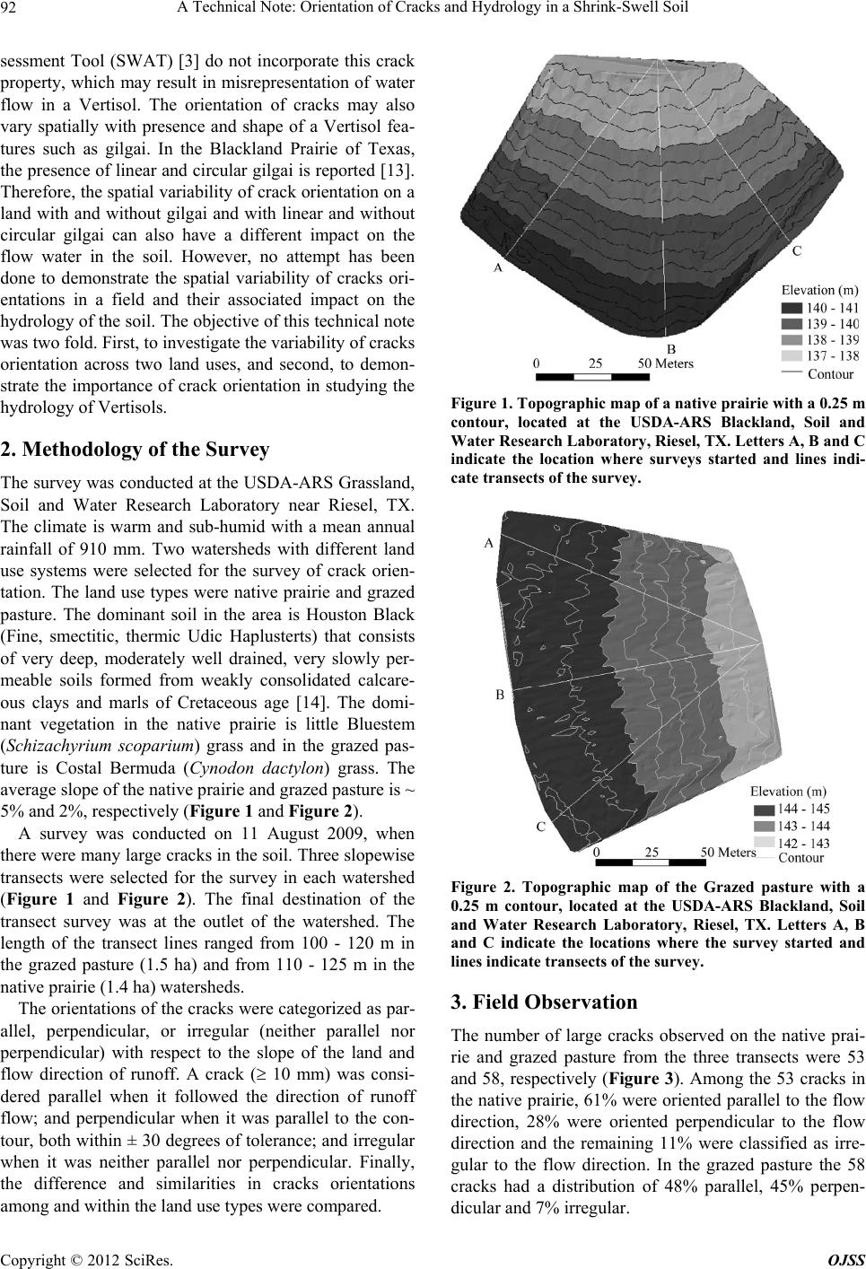
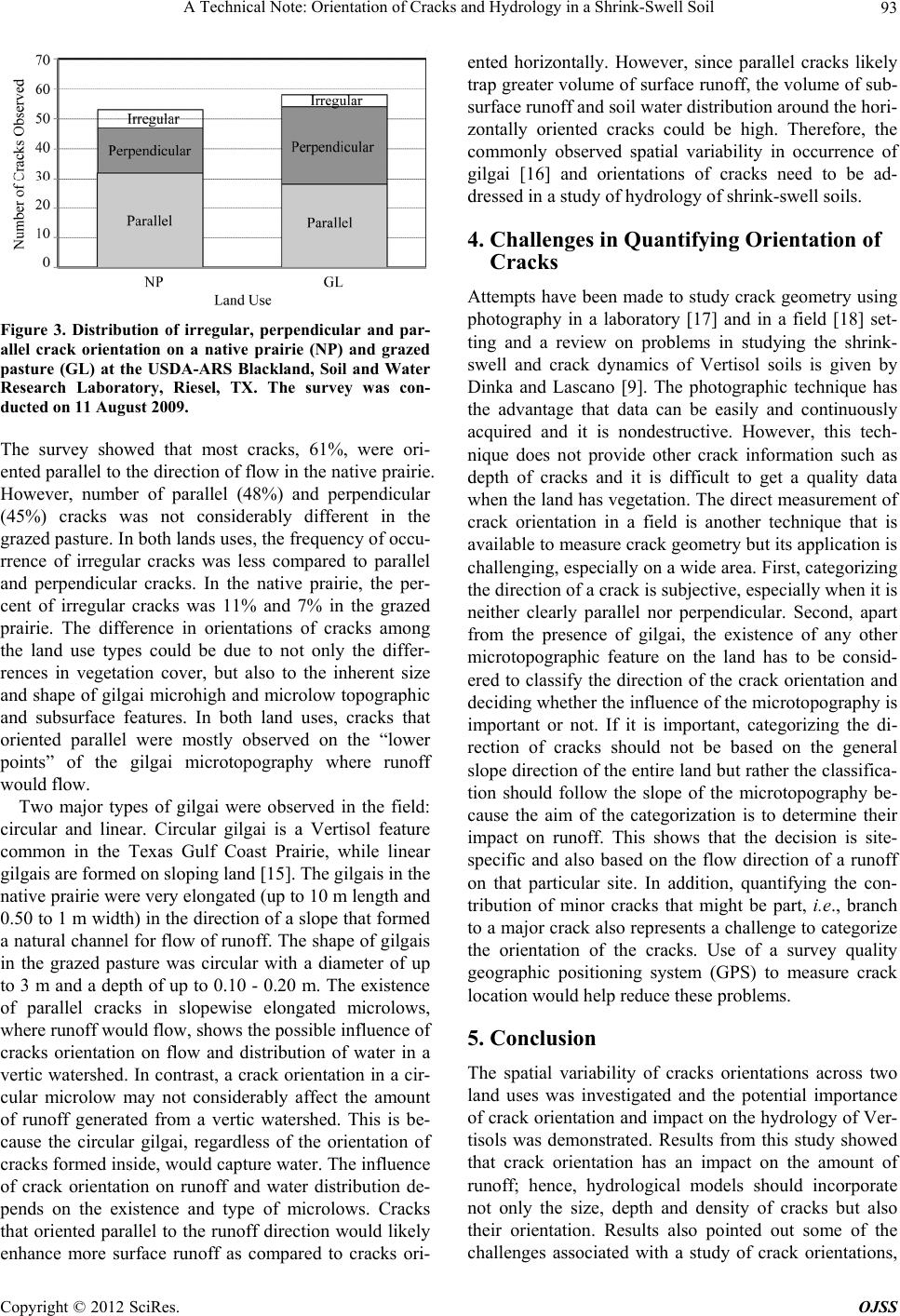
A Technical Note: Orientation of Cracks and Hydrology in a Shrink-Swell Soil
Copyright © 2012 SciRes. OJSS
94
and suggested the importance of developing simple and
practical guidelines to determine crack orientation or
other techniques that could capture all the necessary
crack information such as the size, depth, density and
orientation of cracks needs to be used. Further studies are
necessary to understand whether there is a sp atial pattern
to crack orientations and whether there is a trend on the
distance be tween wid e cracks.
6. Acknowledgments
The Texas AgriLife Research, and a Cooperative Agree-
ment with the USDA NRCS Texas Soil Survey and Na-
tional Science Foundation Grant No. EAR 0911317 in
part supported this work.
REFERENCES
[1] R. Dudal and H. Eswaran, “Distribution, Properties, and
Classification of Vertisols,” In: L. P. Wilding and R.
Puentes, Eds., Publication Soil Management Support Ser-
vices, US Department of Agriculture, Natural Resources
Conservation Service, Washington DC, 1988, pp. 1-22.
[2] D. Smiles and P. A. C. Raats, “Hydrology of Swelling
Clay Soils,” In: M. G. Anderson, Ed., Encyclopedia of
Hydrological Sciences, Wiley, Chichester, Chapter 67,
2005, pp. 1011-1026.
[3] J. G. Arnold, K. N. Potter, K. W. King and P. M. Allen,
“Estimation of Soil Cracking and the Effect on Surface
Runoff in a Texas Blackland Prairie Watershed,” Hydro-
logical Processes, Vol. 19, No. 3, 2005, pp. 589-603.
doi:10.1002/hyp.5609
[4] K. K. Bandyopadhyay, M. Mohanty, D. K. Painuli, A. K.
Misra, K. M. Hati, K. G. Mandal, P. K. Ghosh, R. S.
Chaudhary and C. L. Acharya, “Influence of Tillage Prac-
tices and Nutrient Management on Crack Parameters in a
Vertisol of Central India,” Soil Tillage Research, Vol. 71,
No. 2, 2003, pp. 133-142.
doi:10.1016/S0167-1987(03)00043-6
[5] R. P. S. Júnior and J. J. Boesten, “Simulation of Pesticide
Leaching in a Cracking Clay Soil with the PEARL
Model,” Pest Management Science, Vol. 61, No. 5, 2005,
pp. 432-448. doi:10.1002/ps.1004
[6] J. J. B. Bronswijk, “Relation between Vertical Soil Move-
ments and Water-Content Changes in 457 Cracking Clays,”
Soil Science Society of American Journal, Vol. 55, No. 5,
1991, pp. 1220-1226.
doi:10.2136/sssaj1991.03615995005500050004x
[7] V. Y. Chertkov, “Using Surface Crack Spacing to Predict
Crack Network Geometry in Swelling Soils,” Soil Science
Society of American Journal, Vol. 64, No. 6, 2000, pp.
1918-1921. doi:10.2136/sssaj2000.6461918x
[8] V. Novák, “Soil-Crack Characteristics-Estimation Meth-
ods Applied to Heavy Soils in the NOPEX Area,” Agri-
cultural Forest Meteorology, Vol. 98-99, 1999, pp. 501-
507. doi:10.1016/S0168-1923(99)00119-7
[9] T. M. Dinka and R. J. Lascano, “Challenges and Limita-
tions in Studying the Shrink-Swell and Crack Dynamics
of Vertisol Soils,” Open Journal of Soil Science, 2012,
Article in Press.
[10] I. Daniells, “Degradation and Restoration of Soil Struc-
ture in a Cracking Grey Clay Used for Cotton Produc-
tion,” Australian Journal of Soil Research, Vol. 27, No. 2,
1989, pp. 455-469. doi:10.1071/SR9890455
[11] A. Sz. Kishné, C. L. S. Morgan, Y. Ge and W. L. Miller,
“Antecedent Soil Moisture Affecting Surface Cracking of
a Vertisol in Field Conditions,” Geoderma, Vol. 157, No.
3-4, 2010, pp. 109-117.
doi:10.1016/j.geoderma.2010.03.020
[12] A. Sz. Kishné, C. L. S. Morgan and W. L. Miller, “Verti-
sol Crack Extent Associated with Gilgai and Soil Mois-
ture in the Texas Gulf Coast Prairie,” Soil Science Society
of American Journal, Vol. 73, No. 4, 2009, pp. 1221-
1230. doi:10.2136/sssaj2008.0081
[13] T. M. Dinka, “Shrink-Swell Dynamics of Vertisol Ca-
tenae under Different Land Uses,” Ph.D. Dissertation,
Texas A&M University, College Station, 2011.
[14] USDA-NRCS, 1997, Accessed on 10 June 2009.
www2.ftw.nrcs.usda.gov/osd/dat/H/HEIDEN.html
[15] W. L. Miller, A. S. Kishné, and C. L. S. Morgan, “Verti-
sol Morphology, Classification, and Seasonal Cracking
Patterns in the Texas Gulf Coast Prairie,” Soil Survey Ho-
rizon, Vol. 51, No. 1, 2010, pp. 10-16.
[16] L. P. Wilding, D. Williams, W. Miller, T. Cook and H.
Eswaran, “Close Interval Spatial Variability of Vertisols:
A Case Study in Texas,” In: J. M. Kimble, Ed., Proceed-
ings of Sixth International Soil Correlation Meeting (VI
ISCOM): Characterization, Classification and Utilization
of Cold Aridisols and Vertisols, USDA-SCS, Natl. Soil
Survey Ctr., Lincoln, 1990, pp. 232-247.
[17] X. Peng, R. Horn, S. Peth and A. Smucker, “Quantifica-
tion of Soil Shrinkage in 2D by Digital Image Processing
of Soil Surface,” Soil Tillage Research, Vol. 91, No. 1-2,
2006, pp. 173-180. doi:10.1016/j.still.2005.12.012
[18] B. Velde, “Structure of Surface Cracks in Soil and
Muds,” Geoderma, Vol. 93, No. 1-2, 1999, pp. 101-124.