Journal of Geographic Information System
Vol.08 No.06(2016), Article ID:72743,9 pages
10.4236/jgis.2016.86054
Aerial Extent Analysis and Environmental Problems Identification of Matasagar and Sukhsagar Wetlands in Bangladesh Using GIS and Remote Sensing Tools
Md. Zakiur Rahman1, Md. Shahedur Rashid2
1Department of Geography and Environmental Science, Begum Rokeya University, Rangpur, Bangladesh
2Department of Geography and Environment, Jahangirnagar University, Dhaka, Bangladesh

Copyright © 2016 by authors and Scientific Research Publishing Inc.
This work is licensed under the Creative Commons Attribution International License (CC BY 4.0).
http://creativecommons.org/licenses/by/4.0/


Received: October 26, 2016; Accepted: December 11, 2016; Published: December 14, 2016
ABSTRACT
Bangladesh is a land of wetlands. Basically, most of them are freshwater wetlands and have great influence on the primary economic activities such as agriculture and fisheries of the country. Due to its important role in the harmonizing ecosystem, wetlands demand much attention as a significant part of our environment. Matasagar and Sukhsagar are very important historical wetlands of Bangladesh. But those are endangered today due to lack of public awareness of the dangers of their activities to the environment and unbridled profit making activities of the commercial users of the wetlands. Comparisons of maps and Google images from 1933 to present have shown that the forest areas of the wetlands have been progressively destroyed, and these have greatly affected the biodiversity of these areas mentioned. GIS (Geographic Information System) and remote sensing techniques are used to identify the changes in the aerial extent of those wetlands. This study also tried to explore present environmental conditions by in-situ observation. This is high time; some serious steps should be taken to ensure the conservation and preservation of these areas mentioned.
Keywords:
Historical Wetland, Extent Analysis, Environment Problems, GIS, Remote Sensing

1. Introduction
A wetland is an area that is inundated and saturated by surface water or groundwater with vegetation adapted for life under those soil conditions [1] . Wetlands include a wide variety of habitats such as marshes, peatlands, floodplains, rivers and lakes, and coastal areas such as salt-marshes, mangroves, and sea-grass beds, but also coral reefs and other marine areas no deeper than six meters at low tide, as well as human-made wetlands such as waste-water treatment ponds and reservoirs [2] . The total area of wetlands in Bangladesh has been variously estimated at between seven and eight million hectares, i.e. about 50% of the total land surface. This includes at least 480,000 ha of permanent rivers and streams, 610,000 ha of estuaries and mangrove swamps, between 120,000 and 290,000 ha of haors, baors and beels, over 90,000 ha of large water storage reservoirs, 150,000 - 180,000 ha of small tanks and fish ponds, 90,000 - 115,000 ha of shrimp ponds, and some 5,770,000 ha of land which is seasonally inundated to a depth of 30 cm or more [3] [4] . Wetlands provide many important services to human society, but are at the same time ecologically sensitive and adaptive systems [5] . The gradual destruction of the wetlands leads to an imbalance in the biodiversity of the areas mentioned. Administrations and other related organizations are not taking sufficient steps to protect the destruction of wetlands. To protect this resource, GIS and remote sensing techniques can play a vital role as a modern technology. Remote sensing has been variously defined but basically it is the art or science of telling something about an object without touching it [6] . Remote sensing provides spatially consistent data sets that cover large areas with both high spatial detail and high temporal frequency [7] . Recently, remote sensing has been used in combination with Geographical Information Systems (GIS) and Global Positioning Systems to assess land cover change more effectively than by remote sensing data only [8] . Satellite remote sensing techniques have, therefore, been widely used in detecting and monitoring land cover change at various scales with useful results [9] . On the other hand, Geographical information system (GIS) is a group of tools that analyzes stores, manages, captures and presents visual data that are associated with geographical locations [10] . So, GIS and Remote Sensing techniques can be used for change detection of historical wetlands. Though many works have been done regarding change detection of wetlands but no significant works were found on historical wetlands, especially, in the context of Bangladesh.
The historical wetlands such as―Ramsagar, Matasagar, Sukhsagar, Anandasagar of northern Bangladesh are occupying a large history and environmental significance. Among them, Matasagar and Sukhsagar wetlands of Dinajpur district have been selected for this study (Figure 1). The aim of the study is to identify the historical changes in the coverage and biodiversity of those wetlands and to do an analysis of the environmental problems that those changes have generated using GIS techniques.
2. Data and Methods
This study used CS (cadastral survey) map, Google image 2007, 2010 and 2014 for detecting the chronological changes in the aerial extent of different features of Matasagar and Sukhsagar wetlands using GIS overlay method. Where, BTM (Bangladesh Transverse Mercator) projection (Table 1) was selected for GIS data acquisition, analysis and area calculation. Here, CS maps were considered as the base map for both wetlands. Environmental problems of those wetlands were identified through direct field observation and questionnaire survey.
3. Change Detection and Extent Analysis
Many significant changes have occurred between the geographical features of those study area. Such as―forest area dangerously reduced and the extent of the water bodies fluctuating. These are occurring mainly by human influences. Both wetlands have some changes. The changes of both wetlands are discussed below.

Figure 1. Base map of the study areas (CS map of 1933).

Table 1. Different parameters of BTM (Bangladesh Transverse Mercator) projection.
3.1. Matasagar
The land-use and extent of the geographical features of this study area are negatively changing. Water body and forest land of this wetland are mainly affected. Figure 2 is showing the chronological changes of this wetland. The role of the commercial poultry farm, government organizations and lack of public awareness are leading this wetland to the environmental degradation.
From Figure 3, it is observed that, in 1933-1936, the extent of the water body was 20.93 acres (Figure 4). In 2007, it increased to 23.72 acres (Figure 4). Again in 2010, it increased to 25.62 acres (Figure 4). Finally, in 2014, it is reduced to 22.63 acres (Figure 4). The extent of this wetland is fluctuating because of commercial purpose such as li- vestock and poultry farm. The chronological changes of the features of this wetland are shown in Figure 2.
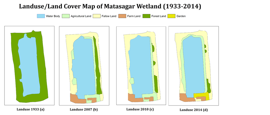
Figure 2. Landuse/land cover maps of Matasagar wetland (1933-2014).

Figure 3. Google images of Matasagar wetland (Year: 2007, 2010 and 2014).
The most affected phenomenon of Matasagar wetland is its forest land. In 1933 total forest area was 24.15 acres (Figure 4). In 2007, it became 3.79 acres and in 2014 the forest area is only 0.97 acres (Figure 4). That means, only 4.01% forest exists today. Due to total deforestation, the biodiversity of this area is almost destroyed.
3.2. Sukhsagar
The extent of different features of Sukhsagar wetland also has been changed over time. Figure 5 is showing the chronological changes of various features of this area. Changes occurred in this area due to human activities. Mainly, local people are responsible these changes. The extent of water body of Sukhsagar wetland has been changing since 1933. In 1933 it was 24.01 acres and in 2014 gradually it became 22.85 acres (Table 2). The cause of this reduction is erosion of wetland’s side. Chronological changes of different features of Sukhsagar are shown in Figure 5 and Figure 6.
The extent of forest area is also changed in Sukhsagar. Forest land of this area stays unchanged. But quality and thickness of forest cover is reduced. In 1933 total forest area was 13.38 acres and still in 2014 it is 13.38 acres (Table 2). The settlement around
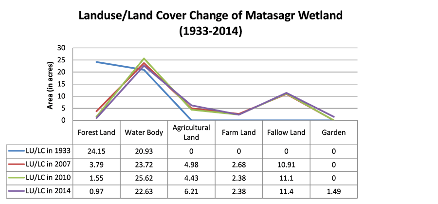
Figure 4. Landuse/land cover change of Matasagar wetland during 1933 to 2014.
Table 2. Landuse/land cover change of Sukhsagar wetland during 1933 to 2014.

Figure 5. Google images of Sukhsagar wetland (Year: 2007, 2010 and 2014).
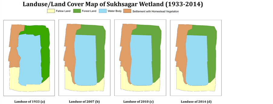
Figure 6. Landuse/land cover maps of Sukhsagar wetland (1933-2014).
this wetland is changed since 1933. In 1933, settlement and homestead land were 8.52 acres. But in 2014, it became 11.06 acres (Table 2). The extent of settlement increased due to growing population. Detailed landuse/land cover change of Sukhsagar wetland is shown in Table 2.
4. Environmental Problems
Many environmental problems have been observed in adjoining areas of Matasagar and Sukhsagar wetlands. Among them, major environmental problems are deforestation, destruction of high land, wetland filling, plantation of alien invasive tree species, cultivation of exotic fishes etc.
4.1. Destruction of High Lands
Here, deforestation (Figure 7(a)) is one of the most vital environmental problems. In Matasagr all most 95.99% forest areas have been destroyed since 1933. Now only 4.01%

Figure 7. Different environmental problems (mostly caused by human interference).
forest area are remaining (Figure 4). This destructive phenomenon is leading this area towards a great danger. The biodiversity of this wetland is almost lost. Birds, wild animals, insects etc. are extinct from these areas. The natural beauty of these areas also became very poor. Matasagar and Sukhsagar already lost the attraction of tourists. Powerful political leaders are mainly responsible for this scenario. Local people are also involved in these destructive events.
4.2. Destruction of High Lands
Destruction of highlands (Figure 7(b)) is another major problem of Matasagar Wetland. Political leaders are clearing the highlands and selling it to the brickfields. That is causing a great harm for those wetlands. The crest is becoming loose and getting eroded during the rainy season. Consequently, depth of the wetland is reducing day by day. Local poor people are also involved with this leveling process. They are cutting down highlands for constructing their home.
4.3. Filing up Wetlands
The extent of the wetlands is reducing due to illegal filling up activities for agricultural purpose. In that case, soils from adjoining highlands are being used for wetland filling (Figure 7(c)).
4.4. Plantation of Alien Invasive Tree Species
Another environmental problem of these study areas is the plantation of alien invasive tree species (Figure 7(d)). In 1980 these areas were covered with Shal (Shorea robusta) trees. But clearing Shal, Akashmoni (Acacia auriculiformis) and Eucalyptus have been planted. Akashmoni and Eucalyptus have an inverse impact on the environment. The transpiration rate of these trees is very high. As a result, the areas are becoming dryer day by day.
4.5. Cultivation of Exotic Fishes
Cultivation of exotic fishes is also a growing concern. Due to the cultivation of exotic fisher both historical wetlands almost lost their native fish diversity.
5. Conclusion
Because of wetland losses and degradation, people are deprived of the ecosystem services that wetlands provide [11] . From the above discussions, it can be said that the major reasons for the destruction of historical wetlands were commercial use and lack of public awareness. Considering these, specific policies and acts should be introduced. Public awareness should be increased and commercial lease should be canceled to protect historical wetlands like Matasagar and Sukhsagar.
Acknowledgements
The authors would like to express gratitude to Mr. Md. Julfikar Ali Hanif, Coordinator, Research and Evaluation, NBI, RDRS Bangladesh, Rangpur for his guidance during this study. In addition, also like to acknowledge RDRS Bangladesh for financial support for field work and data collection. Finally, special thanks go to Mr. Subaran Chandra Sarker, Assistant Professor, Department of Geography and Environmental Science, Begum Rokeya University, Rangpur, Bangladesh for his cordial guidance for publishing this paper in this open access journal.
Cite this paper
Rahman, M.Z. and Rashid, M.S. (2016) Aerial Extent Analysis and Environmental Problems Identification of Matasagar and Sukhsagar Wetlands in Bangladesh Using GIS and Remote Sensing Tools. Journal of Geographic Information System, 8, 683-691. http://dx.doi.org/10.4236/jgis.2016.86054
References
- 1. (2016) Department of Environmental Protection State of Florida Glossary. State of Florida.
http://www.dep.state.fl.us/evergladesforever/about/glossary.htm - 2. An Introduction to the Convention on Wetlands (Previously The Ramsar Convention Manual). Ramsar Convention Secretariat, Gland, Switzerland. Ramsar Convention Hand Book 1, 5th Edition, 9.
- 3. Akonda, A.W. (1989) Wetlands of Bangladesh. In: Scott, D.A., Ed., A Directory of Asian Wetlands, IUCN, Switzerland, 684 p.
https://portals.iucn.org/library/sites/library/files/documents/1989-Scott-001.pdf - 4. Nishat, A. (1993) Freshwater Wetlands in Bangladesh: Status and Issues. Freshwater Wetlands in Bangladesh-Issues and Approaches for Management. IUCN, 9-22.
- 5. Turner, R.K., Van Den Bergh, J.C., Soderqvist, T., Barendregt, A., Van Der Straaten, J., Maltby, E. and Van Ierland, E.C. (2000) Ecological-Economic Analysis of Wetlands: Scientific Integration for Management and Policy. Ecological Economics, 35, 7-23.
https://doi.org/10.1016/S0921-8009(00)00164-6 - 6. Fischer, W.A., Hemphill, W.R. and Kover, A. (1976) Progress in Remote Sensing (1972-1976). Photogrammetria, 32, 33-72.
https://doi.org/10.1016/0031-8663(76)90013-2 - 7. Xiao, J., Shen, Y., Ge, J., Tateishi, R., Tang, C., Liang, Y. and Huang, Z.(2006) Evaluating Urban Expansion and Land Use Change in Shijiazhuang, China, by Using GIS and Remote Sensing. Landscape and Urban Planning, 75, 69-80.
https://doi.org/10.1016/j.landurbplan.2004.12.005 - 8. Muller, D. and Zeller, M. (2002) Land Use Dynamics in the Central Highlands of Vietnam: A Spatial Model Combining Village Survey Data with Satellite Imagery Interpretation. Agricultural Economics, 27, 333-354.
https://doi.org/10.1111/j.1574-0862.2002.tb00124.x - 9. Wilson, E.H., Hurd, J.D., Civco, D.L., Prisloe, M.P. and Arnold, C. (2003) Development of a Geospatial Model to Quantify, Describe and Map Urban Growth. Remote Sensing of Environment, 86, 275-285.
https://doi.org/10.1016/S0034-4257(03)00074-9 - 10. Kenneth, E. (2015) Geographic Information Systems as an Integrating Technology: Context, Concepts, and Definitions. Foote and Margaret Lynch, The Geographer’s Craft Project, Department of Geography, The University of Colorado at Boulder.
- 11. Gardner, R.C., Barchiesi, S., Beltrame, C., Finlayson, C.M., Galewski, T., Harrison, I., Paganini, M., Perennou, C., Pritchard, D.E., Rosenqvist, A. and Walpole, M. (2015) State of the World’s Wetlands and Their Services to People: A Compilation of Recent Analyses. Ramsar Briefing Note No. 7. Gland, Switzerland: Ramsar Convention Secretariat.