Open Journal of Geology
Vol.4 No.5(2014), Article ID:45651,8 pages DOI:10.4236/ojg.2014.45014
An Integrated Geoscientific Approach to Define Zones of Gold Mineralization
—A Case Study in North Sudan
Bijay K. Mishra, N. Sulekha Rao, Sudeep Rautray, Subhranshu Pattanayak
RMSI Private Limited, Auriga, Software Units Layout, Hyderabad, India
Email: bijay.mishra@rmsi.com, sulekha.rao@rmsi.com, sulekha.rao@rmsi.com, subhransu.pattanayak@rmsi.com
Copyright © 2014 by authors and Scientific Research Publishing Inc.
This work is licensed under the Creative Commons Attribution International License (CC BY).
http://creativecommons.org/licenses/by/4.0/


Received 21 March 2014; revised 18 April 2014; accepted 25 April 2014
ABSTRACT
The study area is located in Bayuda desert lying about 400 km from Khartoum in the state of River Nile, North Sudan. The present study aimed to identify gold mineralized zones through an integrated geoscientific approach. The approach integrated the results of geospatial studies, geological mapping, field observations and geochemical data. Remote sensing studies using ASTER and Quickbird data helped to identify the zones of chloritic, sericitic and phyllic alteration signatures and gossan rich zones. Geological mapping and field observations confirmed the presence of gold mineralization along the quartz veins which shared the litho contacts of biotite muscovite schist, biotite muscovite gneiss and silicate gneiss. These gold bearing potential areas were found to be structurally controlled and most of the mineralizations were along the proximity of shear-zones, faults and folds. The gold assay values obtained from the chemical analysis of stream sediment and pitting-trenching samples also confirmed the results of remote sensing and geological mapping. Integration of all these data helped to identify drill holes’ locations in the study area for further exploration. This focused plan facilitated cost and time optimization in exploration activities.
Keywords:Remote Sensing, Geological, Geochemical, Gold, Hydrothermal Alterations, Gossans, Quartz Veins

1. Introduction
Gold exploration in Sudan is known from the pre-historic times of Pharaonic age (3000 years). Due to the prevalence of inhospitable climatic conditions & sparse population, the process of mineral prospecting in the country has been patchy in times. A Lot of exploration work has been carried out in the country but there are still no proper estimates of mineral reserves. Many mineral occurrences still remain unexploited due to inappropriate prospecting methods [1] . Since 1980, different opportunities of modern innovative technologies for gold exploration came into exist because of the joint ventures between Sudan and other foreign investors. From 1980’s, substantial discoveries of gold deposits in the Red Sea Hills encouraged the search for gold, not only in areas of quartz veins, but also in rocks associated with gossans.
In Sudan, gold occurrences located in six greenstone belts namely 1) the red Sea hills in north east Sudan; 2) the Nubian Desert east of Nile River and south Egypt border; 3) the Hofrat En nahas area in the West (Darfur region); 4) the Nuba Mountain west of White Nile; 5) the Blue Nile area in South east Sudan; and 6) the Equatorial region of South Sudan which close to Uganda.
Many workers [2] -[7] studied the different geological environments responsible for gold mineralization occurring in this N and NE part of Sudan. Most gold occurrences in the region linked to a hydrothermal activity that accompanied emplacement of Proterozoic-Early Paleozoic calc-alkaline granitoids [3] [4] . Some gold deposits were related to a shearing episode that post-dated emplacement of all batholithic intrusions and others are thought to have formed by exhalative hydrothermal processes during the break phases of sub-marine volcanic activity [8] [9] . Gold production in northeast Sudan is as old as the Pharoanic regime of Egypt and northern Sudan [7] . There are more than hundred ancient gold mining sites, most of which consist of shallow surface diggings on quartz veins and shear zones.
Several attempts were made to classify gold occurrences in the region [4] [7] [10] [11] but the recently adopted classification is taking the tectonic evolution into consideration based on the mode of occurrence and the nature of mineralization. In this classification, three broad categories of primary gold deposits were recognized in addition to the placer deposits: 1) Pre-metamorphic mineralization (island-arc stage gold): is a syngenetic gold mineralization associated with massive sulphides deposits; 2) Gold mineralization related to the regional tectonometamorphic episodes (orogenic stage gold): Non-stratabound deposits encountered mainly in both calc-alkaline I-type granitoids and metamorphic rocks surrounding them; and 3) Gold mineralization related to shear zones (post-collision gold): This type of mineralization occurs exclusively in the form of auriferous quartz veins that developed along first and second-order shear fracture zones.
Thus, the present study is aimed at utilizing an integrated approach of remote sensing studies, geological mapping and geochemical survey for gold exploration in an identified block in the state of River Nile in North Sudan.
2. Study Area
The study area (Figure 1) covers an approximate area of 1350 sq km which is located near to Bayuda desert lying about 400 km from Khartoum in the state of River Nile, North Sudan. It is naturally a rugged terrain with slight undulations. It has been covered by alluvial/ sandy partials due to Bayuda Desert activities. Volcanic field is observed as ring dykes along the western margin of area. Average elevation of the area is around 400 m.
The study area is having an arid climate. From June to August rainfall becomes active in this area with an average temperature of 34˚C and dry season prevails in September. During hot season sometimes temperature rises to about 49˚C accompanied with dust storm. Prolonged dry season is prominent in the area. Humidity is generally low in this area.
The main drainage sytem of the area is River Nile which is flowing from south to north towards Egypt. North of Khartoum and between 4th and 5th Cataracts, the Nile River executes a remarkable loop around the Bayuda Desert. The course of the Nile is entirely controlled by the underlying basement fold structure. Numbers of wadis are observed along schist complex and gneissic terrenes. These Wadis (Wadi Singer) carries traces of gold with silt and sand particles during rainy season from June to August.
3. Geological Settings of the Study Area
The study area lies in the geosynclinal Bayuda Formation which was subdivided into three rock series, viz. 1) Kurmut series; 2) Rahaba Series and 3) Absol Series [12] (Table 1).
The well foliated and folded rocks of the Kurmut Series are exposed in the eastern and northern parts of the Bayuda area. The rocks of the Kurmut Series mainly consist of metasediments such as quartzites, quartzitic sch-
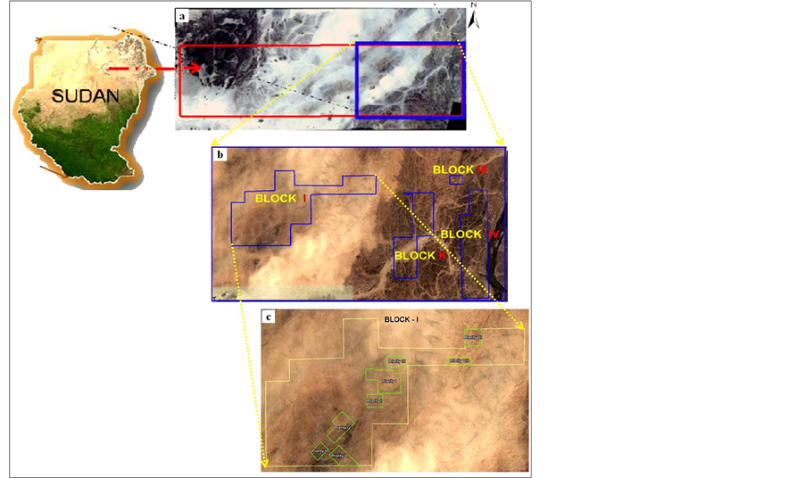
Figure 1. Study Area in North Sudan; (a) Block of 1350 Sq Km area; (b) Four prioritized blocks with total area of 81 Sq Km; and (c) Eight prioritized zones of Block 1..

Table 1. Litho-stratigraphic succession of the study area.
ists, paragneisses, mica schists, graphite schists, calc-mica schists, calc-silicate rocks and marbles with intrusions of metavolcanic rocks. The degree of metamorphism of the Kurmut Series reaches the low to medium stage of the amphibolite facies.
The rocks of the Rahaba Series are conformably overlying the Kurmut Series. The Rahaba Series occupies almost the overall central and western parts of the Bayuda desert. In the basal parts of the series, biotite and hornblende gneisses predominate with numerous amphibolite intercalations. Acidic muscovite-bearing quartz feldspar gneisses, with amphibolite intercalations in thin layers, and lenses of calc-silicate garnetiferous quartzitic mica schists and graphitic schist, form the typical rocks of the upper parts of the Rahaba Series in the northeastern and central part of the Bayuda desert. The acidic gneisses contain many pegmatoids, and in parts thin out and are replaced by a monotonous sequence of biotite gneisses with rare intercalations of amphibolite. The rocks of the Rahaba Series are well and intensely folded.
In southwest, west and northwest parts of Al Shireik, the quartz micaschists, quartzites, graphite schists, manganese schists and rare intercalations of marbles and calc-silicate schists of the Absol Series are underlain by the upper parts of the Rahaba Series. Lenticular bodies of amphibolites and hornblende gneisses are present in these metasediments, which have probably been formed from basic volcanic rocks. The rocks of the Absol Series generally strike northwest in the southern part but then bend round to the north-south, northwest or even west in the northern part of the area.
4. Materials and Methods
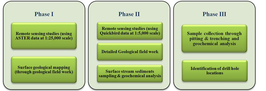
The entire study for gold exploration was carried out in 3 consecutive phases which is shown below:
As a part of phase I, four blocks were shortlisted based on remote sensing (ASTER satellite data analysis) and field geological information. The Phase II study concentrated on these short-listed blocks with large scale geological mapping using Quick Bird data and geochemical sampling which was followed by analysis to further prioritize prospecting sites indicating occurrence of gold bearing formations. The Phase III work involved detailed pitting and trenching that was carried out in one of the prioritized prospecting block.
4.1. Satellite Remote Sensing Studies
Remote sensing studies were carried out in two phases using ASTER and Quick bird satellite data to explore the area in terms of its lithology, structure and geomorphology related to gold mineralization. Various spectral analysis techniques such as band ratio, band depth ratio, spectral angle mapper etc. were implemented [13] . Spectral characteristics of alteration minerals were extracted using SWIR bands of ASTER imagery which shows strong absorption characteristics for alteration minerals. Gossan rich zones and hydrothermal alteration zones viz. chloritic, sericitic and phyllic alterations (Figure 2) were identified using the remote sensing techniques. These alteration zones are the key source of gold mineralization and also the path finder for further detailed exploration study [14] . Quick bird data of 0.5 m resolution was processed to map lithological and structural units pertaining to gold mineralization at larger scale of 1:5000.
4.2. Geological Mapping
Field work was carried out to understand the geology of the area and to validate the alteration signatures in the
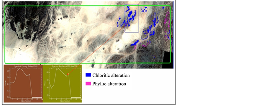
Figure 2. Represents the areas of Chloritic and Phyllic alteration identified from spectral analysis techniques using satellite data.
ground which have been derived from satellite image processing techniques using both ASTER and Quick Bird data. Additionally certain other characteristics such as lithological contacts, structural trend, orientations, deformed features and geomorphological characteristics have been observed and mapped in the field. The quartz veins striking NE-SW direction of different dimensions with high iron (Fe) content in particular were also identified in association with muscovite biotite gneisses and schists (Figure 3). Along with geological mapping, samples were also collected for geochemical analysis to understand the areas of higher ore concentration.
4.3. Geochemical Studies
Geochemical sampling and the analytical results of the samples are very helpful to locate hidden ore bodies that are without visible surface indications. During the field work along with geological mapping, stream samples were collected from the conjunction of 1st, 2nd & 3rd order streams. Around 182 samples were collected and stored in sample kits. The collected samples were transported to geochemical laboratory for chemical analysis for gold and associated elements. The stream sediment sample analysis data has been used as a path finder as well.
For detailed sampling, pitting and trenching (Figure 4) were carried out in one prioritized block. The depth of circular to sub circular pit with approximate 2 meters in diameter varies from 1 to 2 meters and changes accordingly as per terrain conditions. The depth of each level is 0.5 meters and 3 pairs of sample at each level have been collected. The trench length also varies due to extension and dipping direction of auriferous quartz vein and suitable site of gold mineralization. These trenches were 2 to 3 meter in width and 2 - 2.5 meters in depth. Trench samples were collected from channel made at the bottom of the each trench and the sample length was maintained at 10 meters. In total 934 samples were collected, out of which 110 samples were collected from pitting and remaining 824 samples from trenching. Collected samples were reduced to 0.5 kg by coning and quartering for chemical analysis. The results of the chemical analysis data were plotted to understand the areas of high anomalous zones of gold mineralization with respect to the geology of the area.
5. Results
Firstly, considering remote sensing (ASTER) study and geological mapping (at 1:25,000 scale) (Figure 5), 4 blocks (Figure 1) of approximately 81 sq km area were identified. Secondly, remote sensing (Quickbird) study, detailed geological mapping (at 1:5000 scale) and geochemical analysis data of stream sediment samples were integrated and 8 zones in block 1 (Figure 1), 6 in block 2, 1 in block 3 and 4 zones in block 4 have been prioritized. Finally, with the integration of geochemical analysis data of pitting and trenching samples of Block 1, 24 drilling locations have been proposed in this block.
Hydrothermal alterations viz. chloritic, sericitic and phyllic alteration signatures and gossans are identified and mapped in the study area. These alterations play a key role in identifying gold mineralizations zones. The country rocks locally suffered an extensive wall rock alteration (viz. chloritic, sericitic and phyllic alteration)
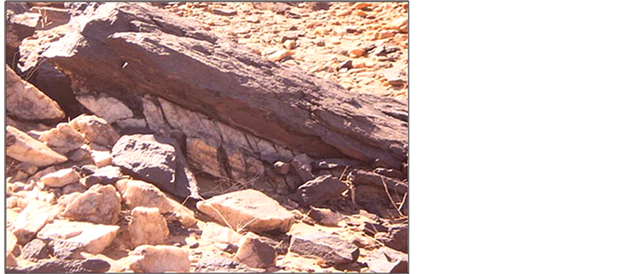
Figure 3. Quartz vein along the contact with biotite muscovite gneiss.
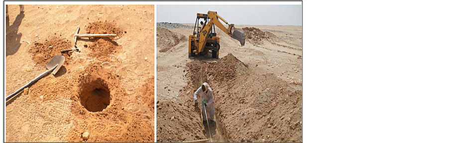
Figure 4. Process of pitting and trenching for sample collection in block I.
caused by the hydrothermal fluids travelling along the path of least resistance through fractures and faults in the country rock. These fluids provide the materials to be deposited in the vein deposit that occurs on the surface. This was identifiable by the remote sensing based alteration signatures which provide the path for carrying out further exploration studies. Similarly as a guide to decipher the surface mineralization gossan rich zones subjected to high iron oxide concentration occurs over sulphide deposits were also mapped through spectral analysis. These sulphide ore bodies occurring in the oxidation zones often contain gold deposits. These alteration zones were identified through remote sensing studies and are verified during the detailed field investigation. Remote sensing and field geological mapping shows the major occurrence of lithological formations viz. biotite muscovite gneiss, amphibole diopside garnet gneiss, metacalcareous rocks, biotite silicate gneiss, quartz mica schist, pegmatite veins and diorite, dolerite dykes as intrusives. In field, gold mineralization is found mostly to be associated with quartz veins and along its periphery. These quartz veins shares the litho contacts of biotite muscovite schist, biotite muscovite gneiss and silicate gneiss as observed in field (Figure 3).
As observed in the field, the gold bearing potential areas are structurally controlled and most of the mineralization’s are along the proximity of shear-zones, faults and folds in the form of auriferous quartz veins. General regional trend of the formation is NE-SW, which varies in between N10˚E to N20˚E and follows E-W direction along the fold axis in the central region of the block, dipping towards 35˚W to 75˚W. Quartz veins follow the same trend of lithounits in most of the areas. In the project area, in-situ gold occurrences are associated with quartz veins. However, at several locations, placer deposits have also been found.
The stream sediment and pitting-trenching sample analysis helped to model the probable mineralized zones exposed on the surface. The chemical analysis results were integrated with geological and structural data to better understand the mineralization. The gold assay value obtained from the chemical analysis of stream sediment
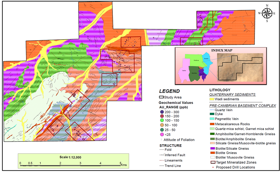
Figure 5. Geology Map of Block 1 with identified prospect zones.
and pitting/trenching samples are only indicative and used as a pathfinder to the auriferous quartz veins. The maximum value of gold mineralization as obtained from the chemical analysis of stream sediments samples in Block I is 500 ppb and the minimum is 25 ppb; in Block II the maximum value is 40 ppb and the minimum is <3; in Block III the maximum is 16 ppb and the minimum is 3 ppb and in Block IV the maximum value is 40 and the minimum is <3. Overall the gold mineralization values varies from <3 ppb to 500 ppb in all the four blocks. Whereas, the gold mineralization values obtained from the chemical analysis of pitting-trenching samples of Block I varies from 14 ppb to 89 ppb with some high values of 135, 151, 154, 164, 168, 184, 255, 261 and 789 ppb.
6. Discussion
Integrated spectral enhancement techniques with geospatial analysis helped to detect the zones of mineralization while geological mapping and geochemical sampling helped to confirm the areas of potential sites for gold mineralization.
The areas of alteration were mapped from remote sensing studies which demarcated the rocks hosting gold mineralization. Majority of the gold mineralization were associated with quartz veins/veinlets and host rocks of primary importance i.e. biotite muscovite schist, biotite muscovite gneiss and silicate gneiss. The veins vary in size and generally the quartz veins & ridges trends coincide with the schistosity of the metavolcano sedimentary rocks (NE-SW).
Gold mineralization of the area was mainly characterized to be associated with shear zones, proximities to fold axis and faults. The gold deposits are highly structurally controlled, disseminated, vein-type lodes whereby the mineralization was found to be aligned by the process of folding and limb thrust. Hence, the delineation of structural features in the study area is aided in the selection of anomalous zones of prime interest for modeling gold potential sites.
Chemical analysis data of stream soil and pitting-trenching samples played a major role in identifying the areas for prospect areas. Samples showing high geochemical assay values were considered as a pathfinder to locate the gold mineralization in the present study area.
7. Conclusion
Gold prospecting areas were identified by integrating spectral signatures of hydrothermal alterations (chloritic, sericitic, phyllic alteration and gossan rich alteration zones), updated lithology, structures and geomorphological features with limited ground truth verification. It was concluded from the study that gold mineralization was mostly found to be associated along the quartz veins in contact of biotite muscovite schist, biotite muscovite gneiss and silicate gneiss. Moreover structurally, gold mineralization in the area was associated with shear zones, proximities to fold axis and faults. The area defined by geospatial analysis and geological mapping was further subjected for geochemical studies. The results of bulk fraction of stream sediment & pitting-trenching samples from the allotted area indicated zones of gold occurrences.
Such an approach was basically adopted to have a focused plan of exploration and facilitate cost and time optimization in exploration activities.
Acknowledgements
The authors are thankful to Dr. K. S. Siva Subramanian for his support and guidance in carrying out this project work.
References
- GRAS (1995) Gold in Sudan. GRAS Rep. Sudan.
- E1-Boushi, I.M. (1972) Geology of the Gebeit Gold Mine, Democratic Republic of the Sudan. Economic Geology, 67, 481-486. http://dx.doi.org/10.2113/gsecongeo.67.4.481
- Vail, J.R. (1978) Outinc of the Geology and Mineral Deposits of the Democratic Republic of Sudan and Adjacent Areas. Overseas Geology and Mineral Resources, 49, 68-68.
- Cottard, F., Deschamps, Y., Bernadet G. and El-Samani, Y. (1986) Gold Deposits of Ariab Area. BRGM Report No. 86 SDN 110, Khartoum, 55.
- Bakhiet, A.K. and Matheis, G. (1993) Gold Productive Volcanogenic Sulphide Mineralization in the Ariab Belt, Red Sea Hills-Sudan: Evidences for Late Proterozoic Seafloor Hydrothermal Systems. In: Thorweihe, U. and Schandelmeier, H., Eds., Geoscientific Research in Northeast Africa, A.A. Balkema, Rotterdam, 533-540.
- Elsamani, Y., Almuslem, A. and El-Tokhi, M. (2001) Geology and Geotectonic Classification of Pan-African Gold Mineralizations in the Red Sea Hills. Sudan. International Geology Review, 43, 1117-1128. http://dx.doi.org/10.1080/00206810109465064
- Klemm, D.D., Klemm, R. and Murr, A. (2001) Gold of the Pharaohs-6000 Years of Gold Mining in Egypt and Nubia. Journal of African Earth Sciences, 33, 643-659. http://dx.doi.org/10.1016/S0899-5362(01)00094-X
- Pohl, W. (1988) Precambrian Metallogeny of NE-Africa. In: El-Gaby, S. and Greiling, R.O., Eds., The Pan-African belt of NE Africa and Adjacent Areas, Earth Evolution Science, Wiesbaden, 319-341.
- Bakheit, A.K. (1991) Geochemical and Tectonic Control of Sulphide-Gold Mineralization in Ariab Mineral District, Red Sea Hills, Sudan. Fachbereich 16—Bergbau und Geowissenschaften, Berlin Technische University, Berlin, 161. http://opensigle.inist.fr/handle/10068/246699
- Aloub, O.A. and Elsamani, Y. (1991) The Geology of Gold Deposits in the Red Sea Hills of the Sudan: Pan-African Tectono-Metamorphic Models. Bull. GRAS, 39, 30-30.
- Botros, N.S. (2004) A New Classification of the Gold Deposits of Egypt. Ore Geology Reviews, 25, 1-37. http://dx.doi.org/10.1016/j.oregeorev.2003.07.002
- Yassin, A.A., Khalil, F.A. and El Shafie, A.G. (1984) Explanatory Note to the Geological Map at the Scale of 1:2,000,000 of the Democratic Republic of the Sudan. The Democratic Republic of the Sudan Ministry of Energy and Mining, Geological & Mineral Resources Department. Bulletin No. 35, 1-63.
- Abduwasit, G. and Reda, A. (2010) Mineral Exploration and Alteration Zone Mapping in Eastern Desert of Egypt Using ASTER Data. ASPRS Annual Conference, San Diego.
- Abdollahi, M.J. Karimpour, M.H. and Kheradmand, A. (2009) Petrography and Sulphur Isotope Studies of Pyrites in the Muteh Gold Deposit. American Journal of Applied Sciences, 6, 1086-1092. http://dx.doi.org/10.3844/ajassp.2009.1086.1092