Geomaterials
Vol.3 No.4(2013), Article ID:37901,6 pages DOI:10.4236/gm.2013.34016
Geothermal Modeling of Kızılcahamam-Çamlıdere Area Using 3D Imaging Technique
Department of Geophysical Engineering, Engineering Faculty, Sakarya University, Sakarya, Turkey
Email: *ayhank@sakarya.edu.tr.
Copyright © 2013 Ayhan Keskinsezer, Günay Beyhan. This is an open access article distributed under the Creative Commons Attribution License, which permits unrestricted use, distribution, and reproduction in any medium, provided the original work is properly cited.
Received January 23, 2013; revised February 23, 2013; accepted March 1, 2013
Keywords: 3D Resistivity Imaging; Geothermal Area
ABSTRACT
Geothermal energy has long been used for various purposes. Geothermal energy was used for bath and health care since ancient times. With the increase in the population, it is being used today for industrial and energy production. This paper examines the geothermal structure of Northern Ankara-NAF (Northern Anatolian Fault Zone) regions to reveal its tectonic features, and the relationships of the region with earthquakes. The 3D geological features of the area are investigated using the resistivity data and tectonic and the quake values. The resistivity data obtained by MTA (Mineral Research and Exploration of Turkey) are reached by geothermal measurements in the area in 1999. In Kızılcahamam town of Ankara Province, geothermal exploration was performed using geoelectrical methods. During the study, electrode measurement scheme was planned according to the Schlumberger expansion. AB/2 spacing is between 1900 m. and 2000 m. Data obtained from geoelectrical methods were processed to delineate the subsurface structure. Also, lithological components were determined and the previously known fault structure was shown. Since the 3D works have been more feasible recently, the received results are transferred into the 3D imaging platform taking advantage of 2D electrical resistivity maps. The low resistivity values obtained in 3D imaging are gathered that the temperature values of the area are high. On the other hand, as the pull-apart between NAF and Kırıkkale fault trending NE-SW of the region is in form of basin, the study area is observed to own opening tectonics. Thus, when the seismic activity is considered, it reveals important findings about the presence of geothermal fields in the local.
1. Introduction
In the investigation of geothermal fields using geophysical methods, in particular, geoelectrical methods have been used successfully in many parts of the world. While the first geoelectrical study conducted in Turkey in the years 1938-1940 was starting in Espiye and Ergani in Turkey with studies of the SP (Self Potential), whereas the first study to be searched on geothermal fields is implemented in Italy in 1950. In these studies, the resistivity maps are enacted for cover rock with low resistivity and under reservoir rock with high resistivity. With the interpretation of maps and natural steam zones, faults in the limestone reservoir are identified in a great accuracy. In Taupo volcanic zone in New Zealand, the borders of geothermal fields are drawn using Wenner electric drillings.
Tezcan [1] and Demirören [2] in Turkey made the geothermal field’s mapped using Schlumberger method based on vertical electrical drillings. On the other hand, Zohdy [3] has established the Mud Volcano area of geothermal resistivity, natural steam zones with the help of the natural voltage (SP) and induced polarization (IP) methods. The first electricity resistivity studies in the region were carried out by Hacısalihoğlu [4], and then it was followed by other studies. Geological studies in the region were made by Karadenizli [5], Öngür [6], Wilson and et al. [7], Yavuz Işık [8] and Yılmazer [9].
In this study, in the area, 3D geological structure of the region is uncovered using the resistivity data and features of the tectonic and seismicity which is made by Hacısalihoğlu [4]. Thus, using 3D imaging obtained from the electrical method, and taking into account tectonic and structural elements, the interpretations were made about the structure of the regions geothermal.
2. Geology and Tectonics
Study area and environments are approximately bounded by the major neotectonic structure, the North Anatolian Fault System in the north, and the İzmir-Ankara-Erzincan Suture in the south. The complex is composed of a polyphased volcanic complex and accompanying volcano-sedimentary sequences evolved during subduction, collisional and post-collisional stages of the northern branch of North Neo-Tethys in the period of Late Campanian-Pliocene [10-13] in contrast to the previous studies that refer to a Miocene-Pliocene age works [6,7, 14-16]. These are the units deposited under the control of neotectonic regime during the Plio-Quaternary period. The neotectonic units are classified into two groups: 1) terrace deposits, and 2) fans to stream bed sediments (Figure 1).
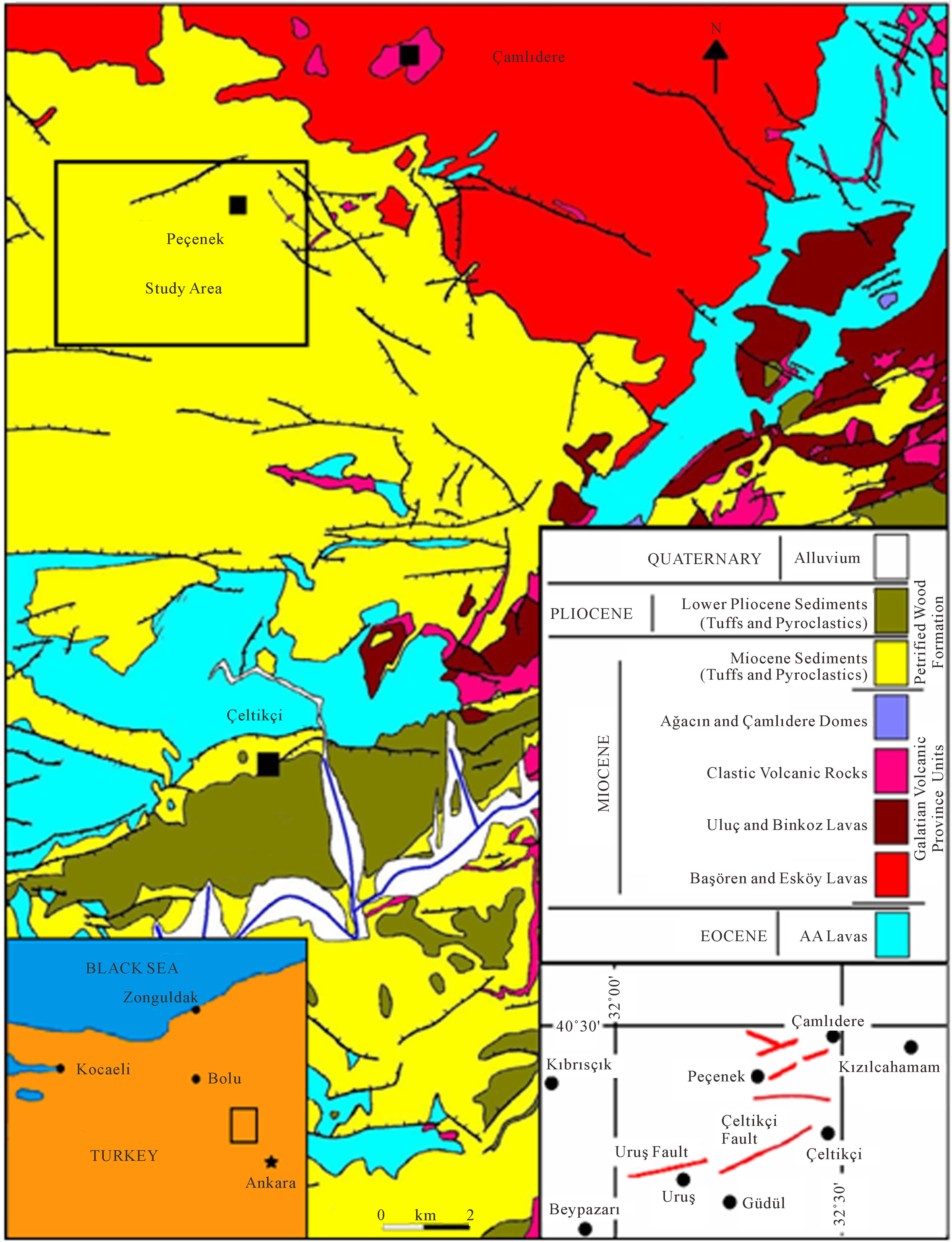
Figure 1. Geological and location map of Northern Ankara region (modifications from [5-9,17-19]).
The geological units in and nearby the Uruş area are classified into two categories based on tectonic activity and style of deformation. These are the first paleotectonic units or basement rocks, and second neotectonic units. The paleotectonic units, lies outside of the purpose of this study, therefore very brief information about their lithostratigraphical characteristic will be given below Kaplan [20].
The basement rocks cropping out in the Uruş area consists of volcanic rock assemblage and the fluviolacus-trine sedimentary sequence with the volcanic and gypsum intercalations. The second type of the basement rocks is a fluvio-lacustrine sedimentary sequence with volcanics and gypsum intercalations. This sequence was previously named as the Hüyükköy Formation [14] and the Uruş Formation [21].
In region, the master fault of the fault set separates volcanics from the Plio-Quaternary basin fill and the underlying fluvial sedimentary sequence. The northern margin-boundary fault of the same area was examined and interpreted to be an oblique-slip normal fault with minor sinistral strike-slip component, and it was named as the Çeltikçi Fault [6,16]. Gökten et al. [14] have also mapped a broad part, including the present study area, of the Çeltikçi Fault Zone, and interpreted the NE-trending faults as oblique-slip normal faults with minor amount of dextral strike-slip component. Demirtaş et al. [17] have named the fault segments exposing in the north of Uruş as the “Uruş-Güdül Fault”, and they interpreted these fault segments as normal faults with dextral strike slip components.
The Güdül-Uruş section of the Çeltikçi morphotectonic depression drained by the antecedent river and its second-order drainage system was first mapped in detail in the present study, and faults determining the northern margin of the Çeltikçi depression were named as the Uruş fault set within the Çeltikçi Fault Zone (Figure 2). Uruş fault set, particularly its master fault, displays a south facing and steep fault scarp with a relief of 700 - 800 m [20].
In general, the Ankara region is divided into a series of long and narrow highlands and depressions of Plio-Quaternary age. The well-identified of these depressions are the Çeltikçi, Çubuk and Mogan (Gölbaşı) depressions. They are bounded by active faults, fault sets and fault zones trending mostly NE, NW, WNW, ENE and NNE. The distribution pattern of these faults is very similar to those in the SW Turkey Extensional Neotectonic Domain. Faults vary in length from a few hundred meters to 25 km [22].
From time to time, master faults, which determine margins of young depressions, reactivate and result in a small cluster of earthquakes up to 5 to 10 in number. Two of them are the 2000. 08. 22 Uruş and the 2003. 02. 27 Çamlıdere earthquake clusters made up of 7 and 8 small-magnitude (4.9 > M > 2.7) earthquakes, respectively. They have been sourced from activation of the master fault of the Uruş Fault Set included in the Çeltikçi Fault Zone and the eastern part of the Bayındır Fault comprising the master fault of the Politick Fault Set [22].
3. Geophysical Studies
Geophysical exploration methods play an important role both in geothermal exploration and development. The studies are required for further management of the geothermal resources. Geoelectrical methods make visible the temperature variation anomalies immediately and most effective methods in setting the drilling sites. Vertical electrical soundings (VES) were applied at Kızılcahamam-Çamlıdere to delineate the most likely location and depth of the geothermal resource.
For interpreting the data set of the 25 VES soundings, Schlumberger (electrode) array and shallow DC resistivity measurements were used. Used electrode spacing ranges from AB/2 = 100 m up to 2000 m in successive steps. Interpretation of resistivity data by using model curves and computer programs has furnished significant information related to the setting and extensions of geothermal fields.
In the end of geophysical research, the determined and measured resistivity values of some geological formations are given in Table 1 below.
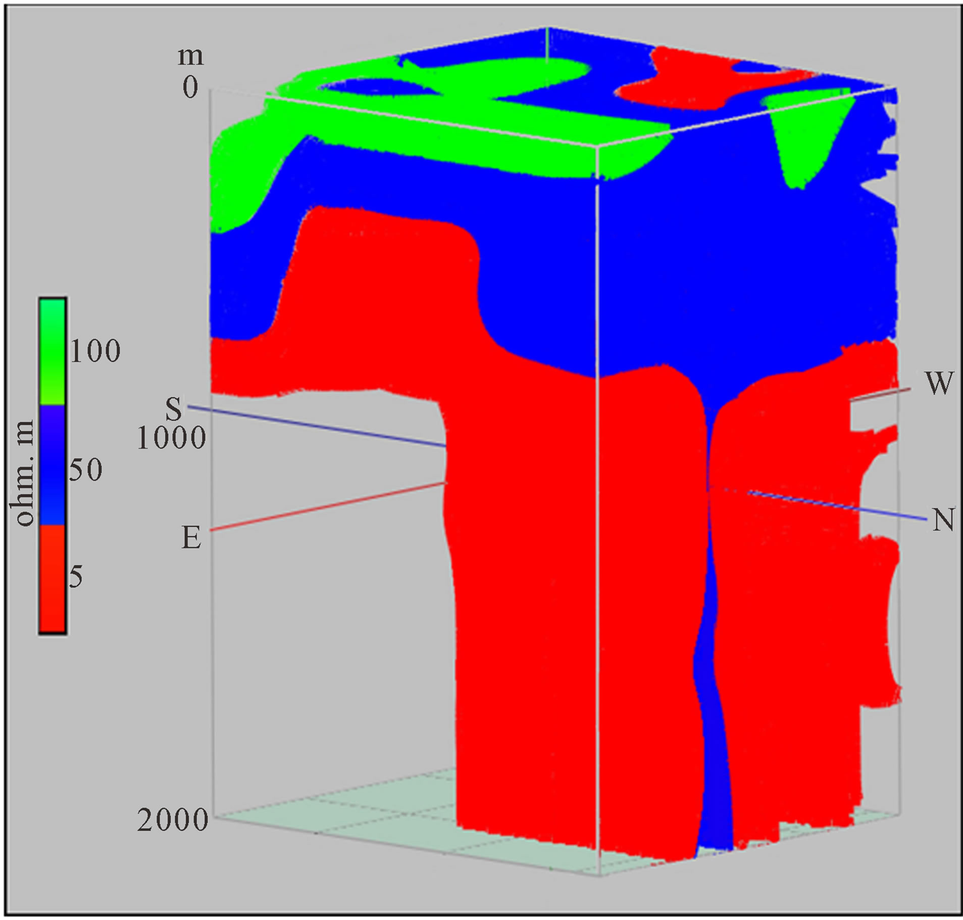
In evaluation of the 3D structure images, it is observed that parts of 50 - 100 ohm-m the green-colored can be in form of high resistivity with feature of cop rock. Similarly, the 20 - 50 ohm-m formations expressed in blue colored are thought to have a transition zone between the reservoir rock and the cap rock (Figure 3(a)).
Here, the red colored area with 5 - 17 ohm-m resistivity pointing out the geothermal reservoir rock is considered that it has a quite important area. It is observed that while the depth of the areas with low electrical resistivity increases, their electrical resistivity decrease rapidly (Figure 3(b)). This is quite clear that it arises from the effect of the opening tectonics in this region. Normal fault tectonics dominate the region, is seen clearly in the values of electrical resistivity. Especially after 800 m is dominated by low resistivity region.
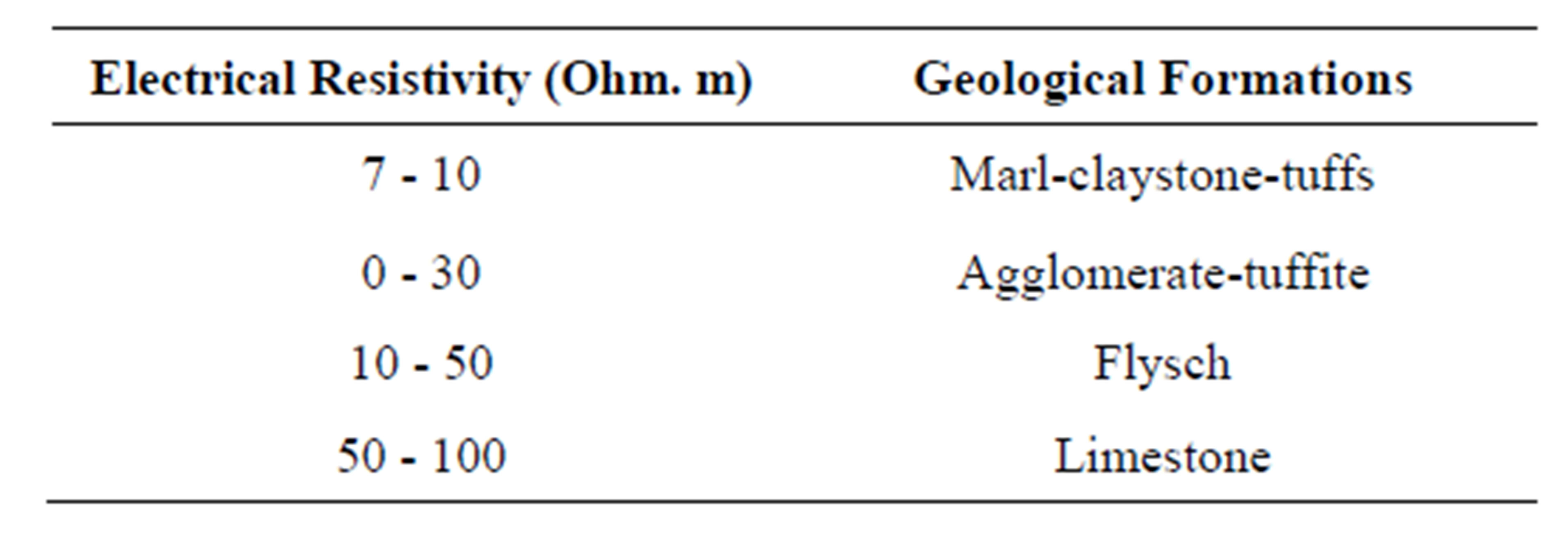
Table 1. Some geological formations measured and identified resistivities [4].
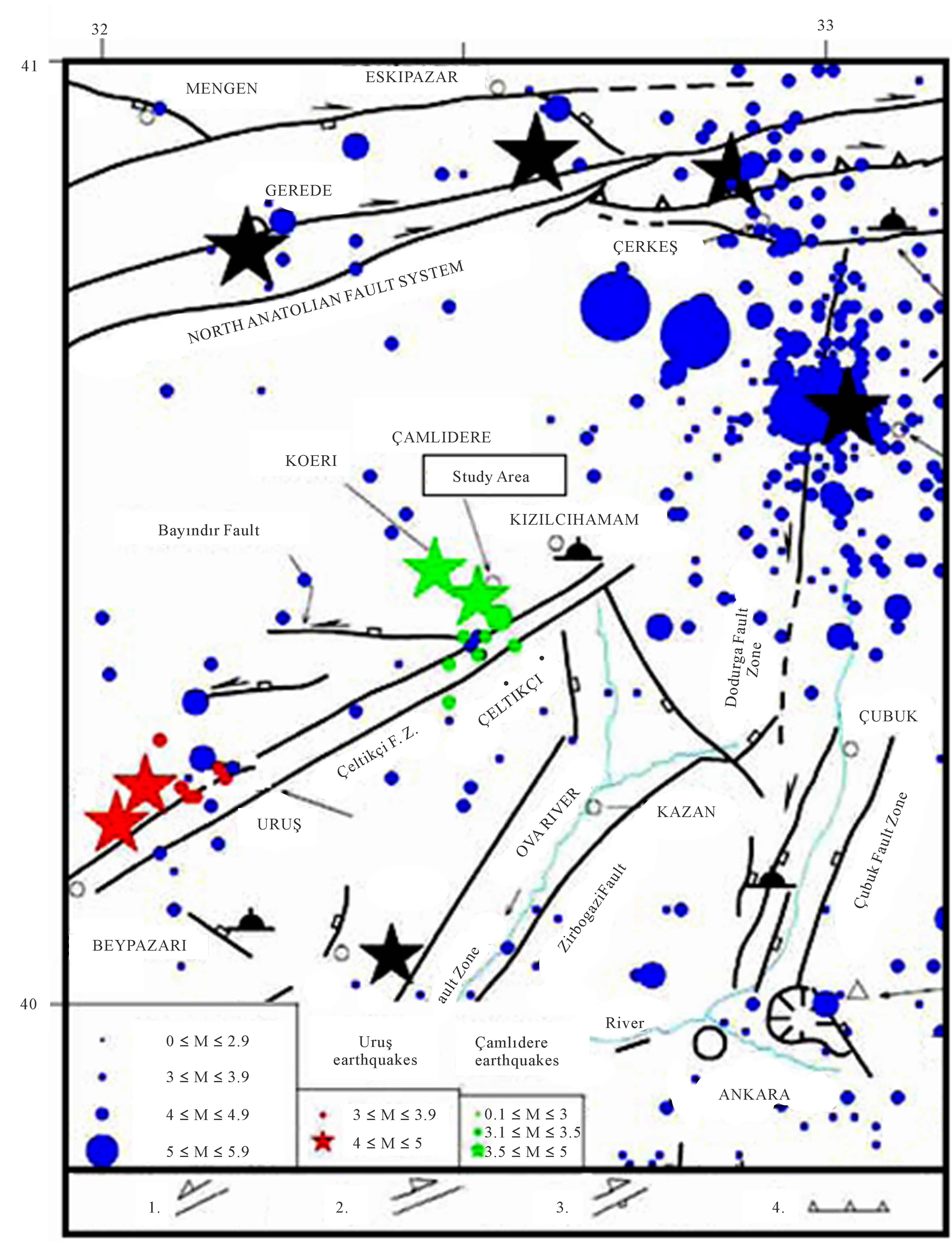
Figure 2. Simplified seismotectonic map of Ankara and its surroundings (As modified from [13,15-17,21]).
 (a)
(a)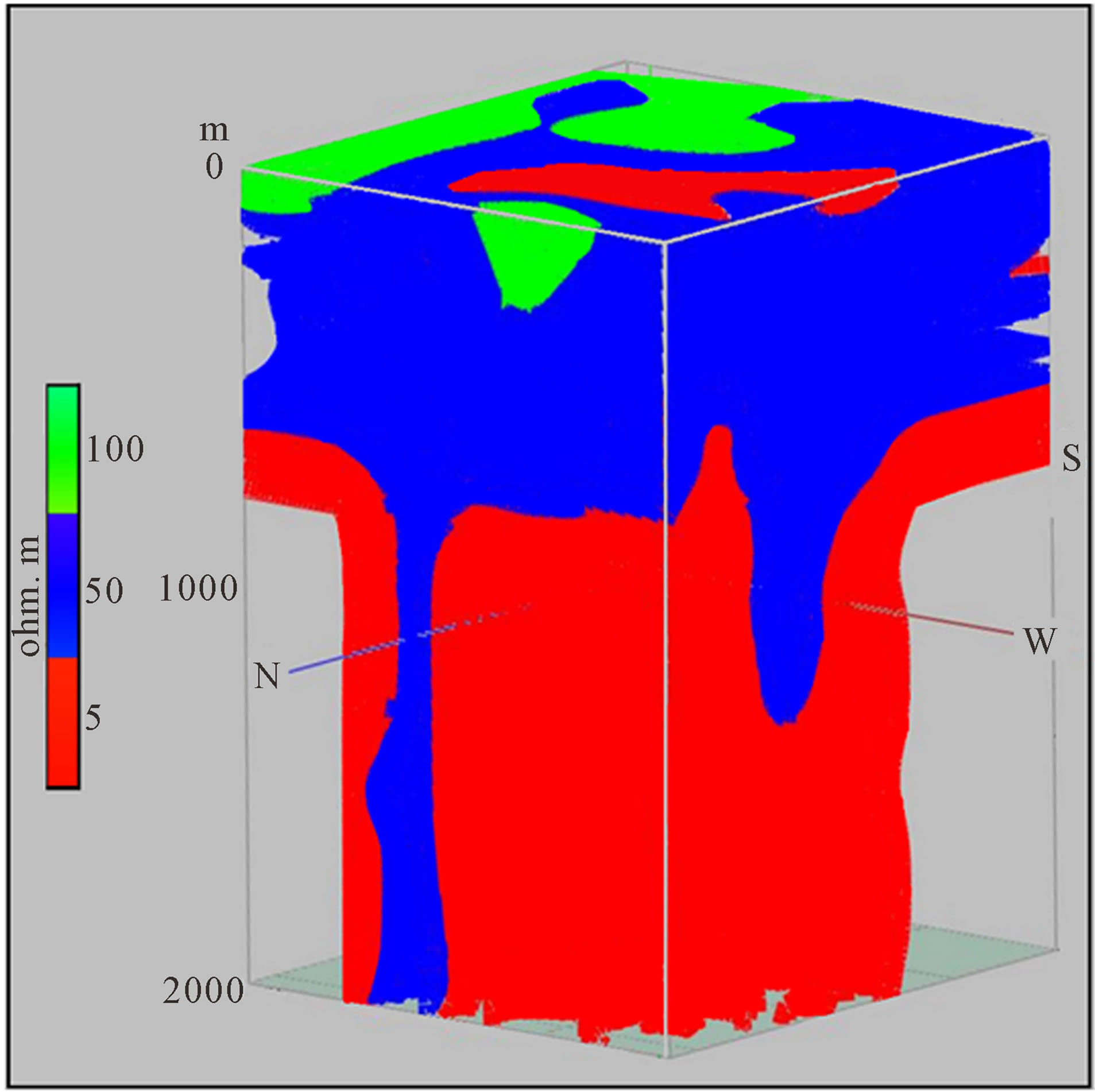 (b)
(b)
Figure 3. (a) N-S 3D electrical resistivity image; (b) E-W 3D electrical resistivity image.
4. Conclusions
In this study, 3D imaging is reached using co-resistivity maps obtained from electrical measurements made in Çamlıdere-Peçenek region. With imaging techniques, the resistivity distributions worked in the region are observed, and its connections with the geological formations have been determined. Thus, the cap rock and reservoir rock formations are identified.
The low resistivity values reached in the imaging indicates the presence of geothermal environment. In addition to this, the tectonic structure in the region and the high seismic activity provides important evidence about the existence of geothermal potential in the region.
5. Acknowledgements
The authors would like to thank Mr. Emrah Budakoğlu and Ms. Nihan Arığ Fettahoğlu for 3D drawings.
REFERENCES
- A. K. Tezcan, “Geothermal Energy Field Dry Steam Generating Facility of Saraykoy-Kizildere. Türkiye 1,” Geothermal Energy Symposium, Ankara, 1971.
- M. Demirören, “Çanakkale-Ayvacık-Tuzla Geothermal Energy Field, Resistivity Survey 1,” Geothermal Energy Symposium, Ankara, 1971.
- A. A. R. Zohdy, “Total-Field Resistivity Mapping and Sounding over Horizontally Layered Media (Bipoledipole Geothermal),” Geophysics, Vol. 43, No. 4, 1978, pp. 748- 766. http://dx.doi.org/10.1190/1.1440851
- İ. Hacısalihoğlu, “Ankara-Çamlıdere-Peçenek-Bolu-Gerede-Aktaş-Salur-Dereköy Field, Geothermal Energy Explorations Geophysic Survey Report,” MTA, 1999.
- L. Karadenizli, “Beypazarı Basin (West Ankara) Sedimentology of the Upper Miocene-Pliocene Gypsum Series,” Bulletin of TJK, Vol. 38, No. 1, 1995, pp. 63-74.
- T. Öngür, “Volcanology and Oil Study of SW-Kızılcahamam,” Bulletin of TJK (Turkey), Vol. 20, No. 2, 1977, pp. 1-12.
- M. Wilson, A. Tankut and N. Güleç, “Tertiary Volcanism of the Galatia Province, Northwest Central Anatolia, Turkey,” Lithos, Vol. 42, No. 1-2, 1997, pp. 105-121. http://dx.doi.org/10.1016/S0024-4937(97)00039-X
- N. Yavuz Işık, “Palynology of Lower Miocene Lacustrine Sediments of the Güvem Basin (Central Anatolia),” Proceedings of the 61th Geological Congress of Turkey, 2008, p. 337.
- I. Yılmazer, “Pliocene Depositional Environment of the Unit around Ankara,” Journal of Geological Engineering, Turkey, Vol. 39, No. 1, 1991, pp. 41-50.
- J. A. Ach, “The Petrochemistry of the Ankara Volcanics, Central Turkey,” M.Sc. Thesis, State University of New York at Albany, 1982.
- J. Keller, D. Jung, F. J. Eckhardt and H. Kreuzer, “Radiometric Ages and Chemical Characterization of the Galatean Andesite Massif, Pontus, Turkey,” Acta Vulcanologica, Vol. 2, 1992, pp. 267-276.
- A. Koçyiğit, “An Example of an Accretionary Forearc basin from Northern Central Anatolia and Its Implications for History of Subduction of Neo-Tethys in Turkey,” Geological Society of American Bulletin, Vol. 103, No. 1, 1991, pp. 22-36. http://dx.doi.org/10.1130/0016-7606(1991)103<0022:AEOAAF>2.3.CO;2
- A. Koçyiğit, “Neotectonics and Seismicity of the General Characteristics of Central Anatolia,” TPJD Bulletin, 2003.
- E. Gökten, V. Özaksoy and K. Karakuş, “Tertiary Volcanics and Tectonic Evolution of the Ayaş-Güdül-Çeltikçi Region,” International Geology Review, Vol. 38, No. 10, 1996, pp. 926-934. http://dx.doi.org/10.1080/00206819709465372
- A. Tankut, O. Akıman, A. Türkmenoğlu, N. Güleç and T. Göker, “Tertiary Volcanic Rocks in Northwest Central Anatolia,” In: Y. Savaşçın and A. H. Erolat, Eds., IESCA Proceedings, Vol. 2, 1990, pp. 450-466.
- V. Toprak, Y. Savaşçın, N. Güleç and A. Tankut, “Structure of the Galatean Volcanic Province,” International Geology Review, Vol. 38, No. 8, 1996, pp. 747-758. http://dx.doi.org/10.1080/00206819709465358
- R. Demirtaş, Y. Irabul, C. Erkmen, B. Baran, M. Yaman, B. Baykal and T. Kılıç, “June 6, 2000 Central (Çankırı) Earthquake (M = 5.9), and August 22, 2000 in UrusGudul (Ankara) Earthquake (M = 4.8),” ATAG-4, Eskişehir, Articles, 2001, pp. 100-123.
- A. Tankut, M. Wilson and T. Yihunie, “Geochemistry and Tectonic Setting of Tertiary Volcanism in the Güvem Area, Anatolia, Turkey,” Journal of Volcanology and Geothermal Research, Vol. 85, No. 1-4, 1998, pp. 285- 301. http://dx.doi.org/10.1016/S0377-0273(98)00060-2
- M. Hatipoğlu and N. Türk, “A Combined Polarizing Microscope, XRD, SEM, and Specific Gravity Study of the Petrified Woods of Volcanic Origin from the Çamlıdere- Çeltikçi-Güdül Fossil Forest, in Ankara, Turkey,” Journal of African Earth Sciences, Vol. 53, No. 4-5, 2009, pp. 141-157. http://dx.doi.org/10.1016/j.jafrearsci.2009.01.001
- T. Kaplan, “Neotectonics and Seismicity of the Ankara Region: A Case Study in the Uruş Area,” Partial Fulfillment of The Requirements Forth Degree of Master of Science, Middle East Technical University, 2004, 98 p.
- A. Türkecan, N. Hepşen, I. Papak, B. Akbaş, A. Dinçel, S. Karataş, İ. Özgür, E. Akay, Y. Bedi, M. Sevin, G. Mutlu, D. Sevin, E. Ünay and G. Saraç, “Seben-Gerede (Bolu), Güdül-Beypazarı (Ankara) and Çerkeş-Mediumleaded (Çankırı) districts (Köroğlu Mountains) Geology and Petrology of Volcanic Rocks,” MTA Report No. 9193, 1991, 118 p.
- A. Koçyiğit and T. Kaplan, “Seismical Outline of Ankara Region: A Case Study on the 2000. 08. 22 Uruş and the 2003. 02. 27 Çamlıdere Earthquakes, Ankara-Turkey. Active Tectonics Research Group 8 Meeting (ATAG-8),” Fırat University, Elazığ, 2004.
NOTES
*Corresponding author.