Paper Menu >>
Journal Menu >>
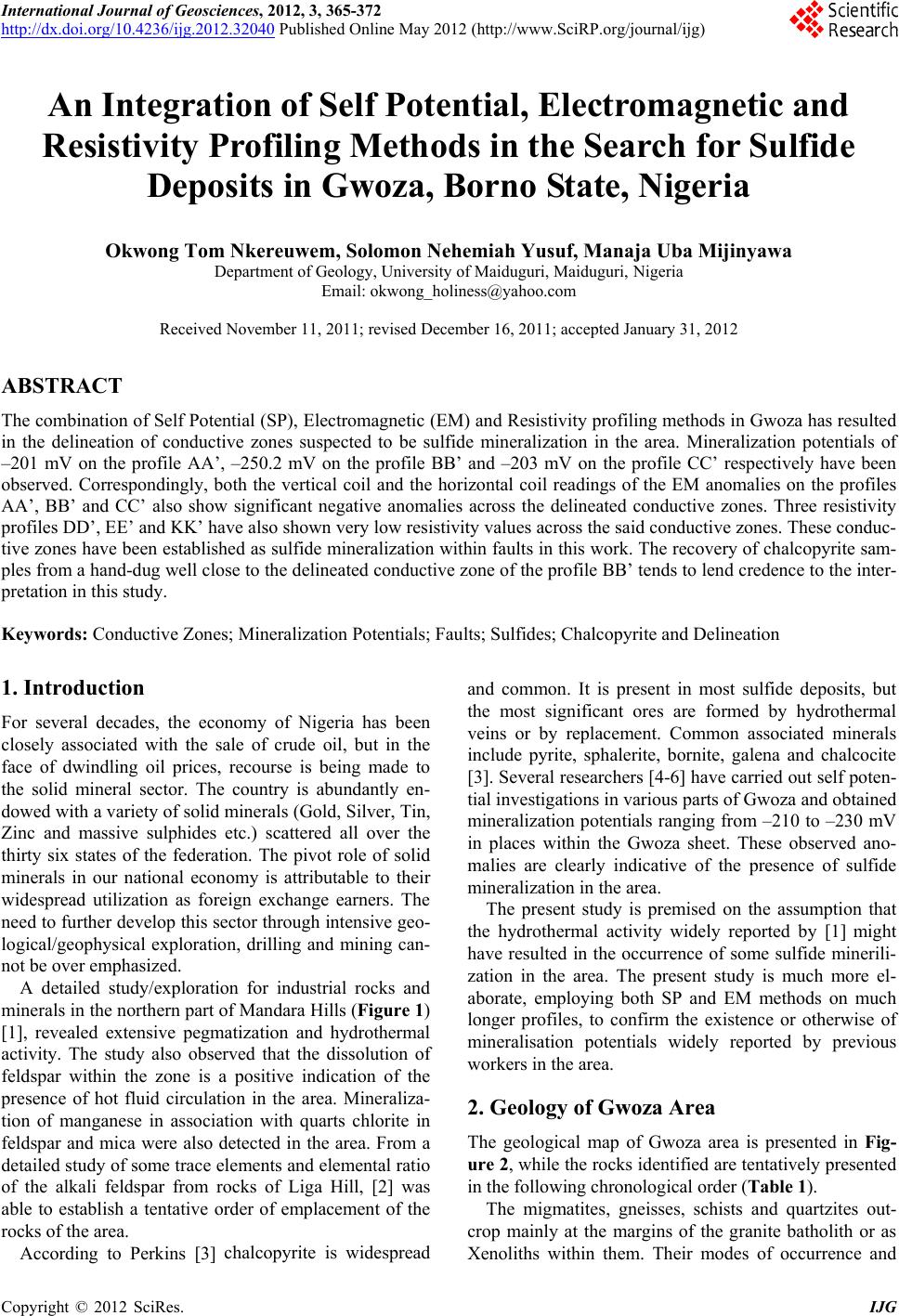 International Journal of Geosciences, 2012, 3, 365-372 http://dx.doi.org/10.4236/ijg.2012.32040 Published Online May 2012 (http://www.SciRP.org/journal/ijg) An Integration of Self Potential, Electr o magnetic and Resistivity Profiling Methods in the Search for Sulfide Deposits in Gwoza, Borno State, Nigeria Okwong Tom Nkereuwem, Solomon Nehemiah Yusuf, Manaja Uba Mijinyawa Department of Geology, University of Maiduguri, Maiduguri, Nigeria Email: okwong_holiness@yahoo.com Received November 11, 2011; revised December 16, 2011; accepted January 31, 2012 ABSTRACT The combination of Self Potential (SP), Electromagnetic (EM) and Resistivity profiling methods in Gwoza has resulted in the delineation of conductive zones suspected to be sulfide mineralization in the area. Mineralization potentials of –201 mV on the profile AA’, –250.2 mV on the profile BB’ and –203 mV on the profile CC’ respectively have been observed. Correspondingly, both the vertical coil and the horizontal coil readings of the EM anomalies on the profiles AA’, BB’ and CC’ also show significant negative anomalies across the delineated conductive zones. Three resistivity profiles DD’, EE’ and KK’ have also shown very low resistivity values across the said conductive zones. These conduc- tive zones have been established as sulfide mineralization within faults in this work. The recovery of chalcopyrite sam- ples from a hand-dug well close to the delineated conductive zone of the profile BB’ tends to lend credence to the inter- pretation in this study. Keywords: Conductive Zones; Mineralization Potentials; Faults; Sulfides; Chalcopyrite and Delineation 1. Introduction For several decades, the economy of Nigeria has been closely associated with the sale of crude oil, but in the face of dwindling oil prices, recourse is being made to the solid mineral sector. The country is abundantly en- dowed with a variety of solid minerals (Gold, Silver, Tin, Zinc and massive sulphides etc.) scattered all over the thirty six states of the federation. The pivot role of solid minerals in our national economy is attributable to their widespread utilization as foreign exchange earners. The need to further develop this sector through intensive geo- logical/geophysical exploration, drilling and mining can- not be over emphasized. A detailed study/exploration for industrial rocks and minerals in the northern part of Mandara Hills (Figure 1) [1], revealed extensive pegmatization and hydrothermal activity. The study also observed that the dissolution of feldspar within the zone is a positive indication of the presence of hot fluid circulation in the area. Mineraliza- tion of manganese in association with quarts chlorite in feldspar and mica were also detected in the area. From a detailed study of some trace elements and elemental ratio of the alkali feldspar from rocks of Liga Hill, [2] was able to establish a tentative order of emplacement of the rocks of the area. According to Perkins [3] chalcopyrite is widespread and common. It is present in most sulfide deposits, but the most significant ores are formed by hydrothermal veins or by replacement. Common associated minerals include pyrite, sphalerite, bornite, galena and chalcocite [3]. Several researchers [4-6] have carried out self poten- tial investigations in various parts of Gwoza and obtained mineralization potentials ranging from –210 to –230 mV in places within the Gwoza sheet. These observed ano- malies are clearly indicative of the presence of sulfide mineralization in the area. The present study is premised on the assumption that the hydrothermal activity widely reported by [1] might have resulted in the occurrence of some sulfide minerili- zation in the area. The present study is much more el- aborate, employing both SP and EM methods on much longer profiles, to confirm the existence or otherwise of mineralisation potentials widely reported by previous workers in the area. 2. Geology of Gwoza Area The geological map of Gwoza area is presented in Fig- ure 2, while the rocks identified are tentatively presented in the following chronological order (Table 1). The migmatites, gneisses, schists and quartzites out- crop mainly at the margins of the granite batholith or as Xenoliths within them. Their modes of occurrence and C opyright © 2012 SciRes. IJG 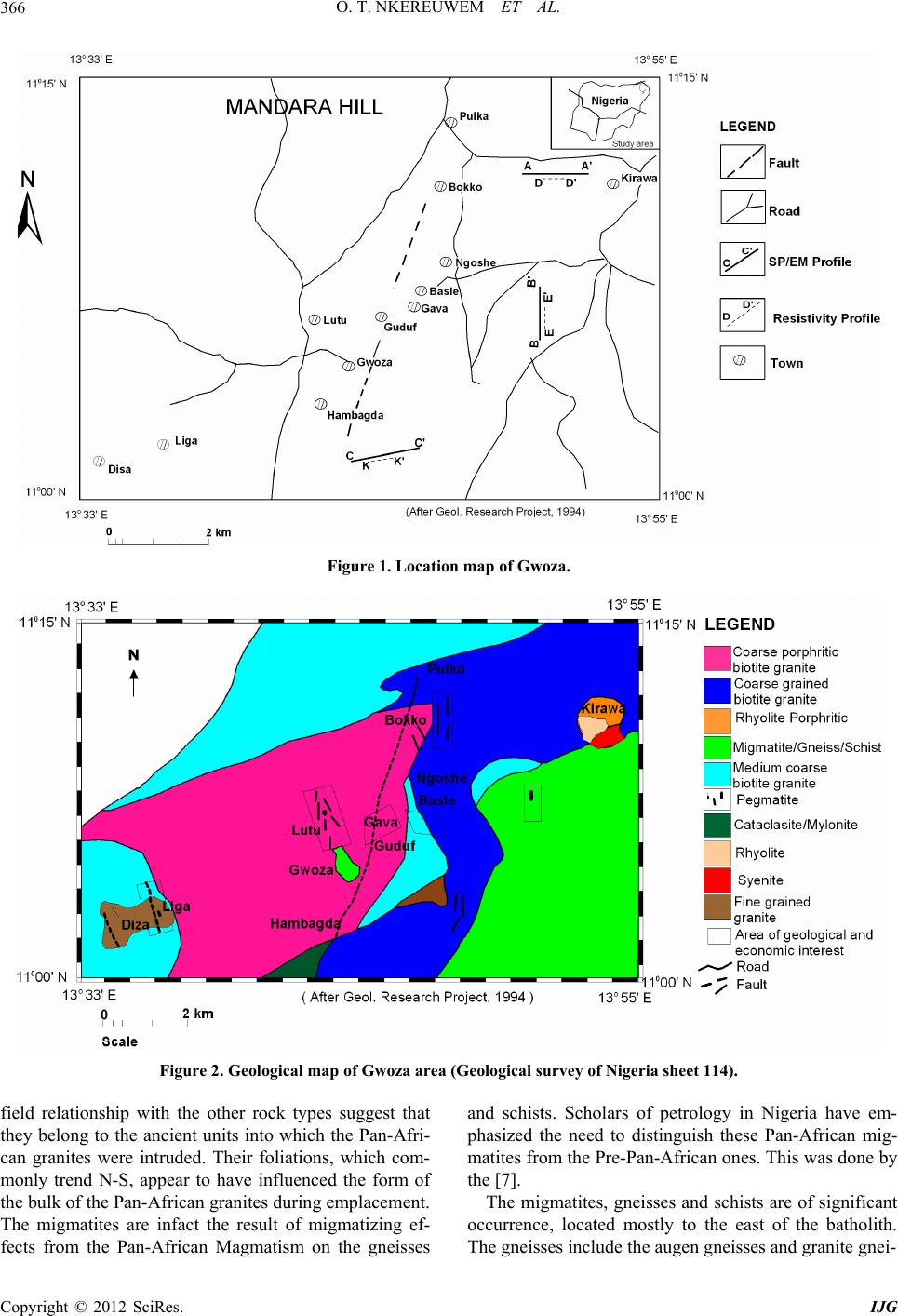 O. T. NKEREUWEM ET AL. 366 Figure 1. Location map of Gwoza. Figure 2. Geological map of Gwoza area (Geological survey of Nigeria sheet 114). field relationship with the other rock types suggest that they belong to the ancient units into which the Pan-Afri- can granites were intruded. Their foliations, which com- monly trend N-S, appear to have influenced the form of the bulk of the Pan-African granites during emplacement. The migmatites are infact the result of migmatizing ef- fects from the Pan-African Magmatism on the gneisses and schists. Scholars of petrology in Nigeria have em- phasized the need to distinguish these Pan-African mig- matites from the Pre-Pan-African ones. This was done by the [7]. The migmatites, gneisses and schists are of significant occurrence, located mostly to the east of the batholith. The gneisses include the augen gneisses and granite gnei- Copyright © 2012 SciRes. IJG 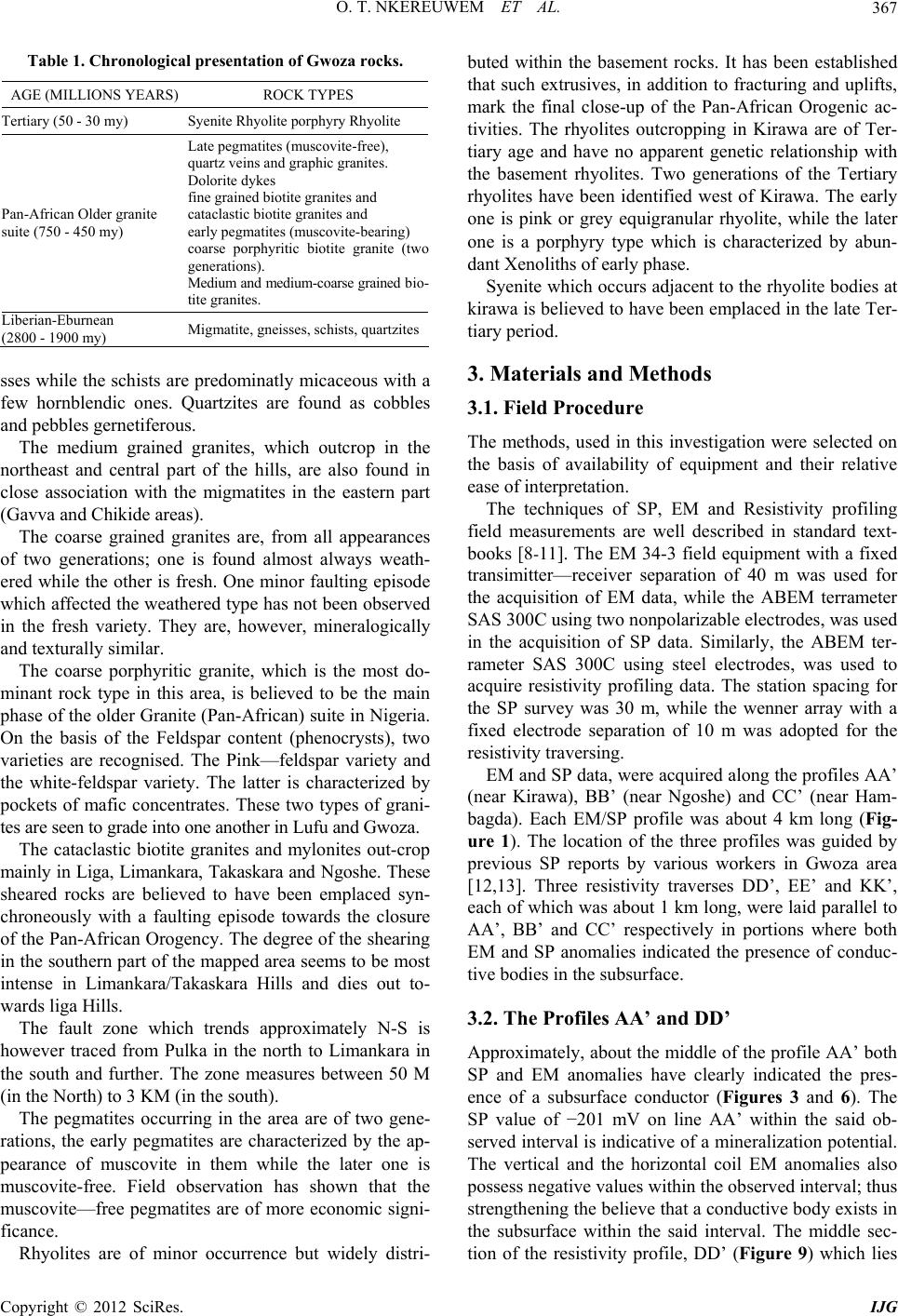 O. T. NKEREUWEM ET AL. 367 Table 1. Chronological presentation of Gwoza rocks. AGE (MILLIONS YEARS) ROCK TYPES Tertiary (50 - 30 my) Syenite Rhyolite porphyry Rhyolite Pan-African Older granite suite (750 - 450 my) Late pegmatites (muscovite-free), quartz veins and graphic granites. Dolorite dykes fine grained biotite granites and cataclastic biotite granites and early pegmatites (muscovite-bearing) coarse porphyritic biotite granite (two generations). Medium and medium-coarse grained bio- tite granites. Liberian-Eburnean (2800 - 1900 my) Migmatite, gneisses, schists, quartzites sses while the schists are predominatly micaceous with a few hornblendic ones. Quartzites are found as cobbles and pebbles gernetiferous. The medium grained granites, which outcrop in the northeast and central part of the hills, are also found in close association with the migmatites in the eastern part (Gavva and Chikide areas). The coarse grained granites are, from all appearances of two generations; one is found almost always weath- ered while the other is fresh. One minor faulting episode which affected the weathered type has not been observed in the fresh variety. They are, however, mineralogically and texturally similar. The coarse porphyritic granite, which is the most do- minant rock type in this area, is believed to be the main phase of the older Granite (Pan-African) suite in Nigeria. On the basis of the Feldspar content (phenocrysts), two varieties are recognised. The Pink—feldspar variety and the white-feldspar variety. The latter is characterized by pockets of mafic concentrates. These two types of grani- tes are seen to grade into one another in Lufu and Gwoza. The cataclastic biotite granites and mylonites out-crop mainly in Liga, Limankara, Takaskara and Ngoshe. These sheared rocks are believed to have been emplaced syn- chroneously with a faulting episode towards the closure of the Pan-African Orogency. The degree of the shearing in the southern part of the mapped area seems to be most intense in Limankara/Takaskara Hills and dies out to- wards liga Hills. The fault zone which trends approximately N-S is however traced from Pulka in the north to Limankara in the south and further. The zone measures between 50 M (in the North) to 3 KM (in the south). The pegmatites occurring in the area are of two gene- rations, the early pegmatites are characterized by the ap- pearance of muscovite in them while the later one is muscovite-free. Field observation has shown that the muscovite—free pegmatites are of more economic signi- ficance. Rhyolites are of minor occurrence but widely distri- buted within the basement rocks. It has been established that such extrusives, in addition to fracturing and uplifts, mark the final close-up of the Pan-African Orogenic ac- tivities. The rhyolites outcropping in Kirawa are of Ter- tiary age and have no apparent genetic relationship with the basement rhyolites. Two generations of the Tertiary rhyolites have been identified west of Kirawa. The early one is pink or grey equigranular rhyolite, while the later one is a porphyry type which is characterized by abun- dant Xenoliths of early phase. Syenite which occurs adjacent to the rhyolite bodies at kirawa is believed to have been emplaced in the late Ter- tiary period. 3. Materials and Methods 3.1. Field Procedure The methods, used in this investigation were selected on the basis of availability of equipment and their relative ease of interpretation. The techniques of SP, EM and Resistivity profiling field measurements are well described in standard text- books [8-11]. The EM 34-3 field equipment with a fixed transimitter—receiver separation of 40 m was used for the acquisition of EM data, while the ABEM terrameter SAS 300C using two nonpolarizable electrodes, was used in the acquisition of SP data. Similarly, the ABEM ter- rameter SAS 300C using steel electrodes, was used to acquire resistivity profiling data. The station spacing for the SP survey was 30 m, while the wenner array with a fixed electrode separation of 10 m was adopted for the resistivity traversing. EM and SP data, were acquired along the profiles AA’ (near Kirawa), BB’ (near Ngoshe) and CC’ (near Ham- bagda). Each EM/SP profile was about 4 km long (Fig- ure 1). The location of the three profiles was guided by previous SP reports by various workers in Gwoza area [12,13]. Three resistivity traverses DD’, EE’ and KK’, each of which was about 1 km long, were laid parallel to AA’, BB’ and CC’ respectively in portions where both EM and SP anomalies indicated the presence of conduc- tive bodies in the subsurface. 3.2. The Profiles AA’ and DD’ Approximately, about the middle of the profile AA’ both SP and EM anomalies have clearly indicated the pres- ence of a subsurface conductor (Figures 3 and 6). The SP value of −201 mV on line AA’ within the said ob- served interval is indicative of a mineralization potential. The vertical and the horizontal coil EM anomalies also possess negative values within the observed interval; thus strengthening the believe that a conductive body exists in the subsurface within the said interval. The middle sec- tion of the resistivity profile, DD’ (Figure 9) which lies Copyright © 2012 SciRes. IJG  O. T. NKEREUWEM ET AL. Copyright © 2012 SciRes. IJG 368 A A ’ Distance (m) Figure 3. SP profile along line A-A’. BB’ Distance (m) Figure 4. SP profile along line B-B’. C C’ Distance (m) Figure 5. SP profile along line C-C’.  O. T. NKEREUWEM ET AL. 369 A A ’ H-Coil V-Coil Receiver Distance (m) Figure 6. EM profile along line A-A’. H-Coil V-Coil B B’ H-Coil V-Coil Series1 Receiver Distance (m) Figure 7. EM profile along line B-B’. CC’ H-Coil V-Coil Series1 Receiver Distance (m) Figure 8. EM profile along line C-C’. Copyright © 2012 SciRes. IJG  O. T. NKEREUWEM ET AL. Copyright © 2012 SciRes. IJG 370 3.4. The Profiles CC’ and KK’ across the said suspected conductive zone, also displays very low resistivity values thereby confirming the exis- tence of a subsurface conductor within the anomalous zones of the profiles AA’ and DD’. The negative picks of the EM and SP anomalies along line AA’ correspond to the point (Lat. 11˚11'N, Long. 13˚46'12"E), while the conductive zone of the resistivity anomaly along the line DD’ is located at the point (Lat. 11˚10'N, Long. 13˚46'12"E). Towards the beginning of the profile CC’, both SP and EM anomalies (Figures 5 and 8) clearly indicate the presence of a conductive zone as shown in Figure 5. The SP value of −203 mV within the said zone is suggestive of a mineralization potential. The negative anomalies displayed by both the vertical and the horizontal coil readings of the EM anomalies across the said conductive zone of the profile, strongly suggest the presence of a subsurface conductor. The low resistivity zone along the parallel resistivity profile KK’ (Figure 11) also corre- sponds to the observed anomalous zone on the profile CC’ as indicated in Figure 11. The negative picks of the EM and SP anomalies along the line CC’ correspond to the point (Lat. 11˚03'N, Long. 13˚39'E), while the con- ductive zone of the resistivity anomaly along line KK’ is located at the point (Lat. 11˚01'N, Long. 13˚39'E). 3.3. The Profiles BB’ and EE’ Towards the end of the profile BB’, both SP and EM anomalies have revealed a zone of high conductivity within the same interval of the said profile. The SP value of −250.2 mV (Figure 4) within this anomalous zone is suggestive of a mineralization potential. Both the vertical and the horizontal coil readings of the EM anomalies within the same interval of the profile are also negative. Similarly, the portion of the resistivity profile EE’ (Fig- ures 7 and 10) with the lowest resistivity values also corresponds to the same anomalous zone revealed by SP and EM anomalies. The negative picks of the EM and SP anomalies along line BB’ correspond to the point (Lat. 11˚03'N, Long. 13˚46'12"E), while the conductive zone of the resistivity anomaly along line DD’ is located at the point (Lat. 11˚03'N, Long. 13˚46'12"E). 4. Findings The applications of the SP, EM and resistivity traversing methods in the quest for sulfide mineralization in Gwoza and its environs, have resulted in the delineation of con- ductive zones which are interpreted as sulfide minerali- zation within faults in this study. This work has also de- monstrated that the hydrothermal activity widely re- ported by [6], might have resulted in the occurrence of Figure 9. Resistivity profile along line D-D’.  O. T. NKEREUWEM ET AL. 371 Figure 10. Resistivity profile along line E-E’. Figure 11. Resistivity profile along line K-K’. some sulfide minerilization in the area. REFERENCES [1] M. R. Islam, S. Ostaviscuk and S. Baba, “A Report on Geological Studies and Exploration of Industrial Rocks and Minerals in the Northern Part of the Mandara Hill, Nigeria,” Annals of Borno, University of Maiduguri, Vol. 3, 1986, pp. 279-281. [2] S. Baba, “Some Trace Elements Geochemistry of Alkali Copyright © 2012 SciRes. IJG  O. T. NKEREUWEM ET AL. 372 Feldspars from Rocks of Liga Hills, Northeastern Nigeria, Borno,” Borno Journal of Geology, Vol. 2, No. 1, 1997, pp. 17-26. [3] D. Perkins, “Minerology,” Pearson Education Inc., Noida, 2002, pp. 350-354. [4] A. Y. Ali, “Self Potential Investigation for Sulfide Miner- alization: A Case Study of Barawa Village, Gwoza Local Area, Borno State,” Unpublished B.Sc. Project Report, University of Maiduguri, Maiduguri, 2002. [5] I. V. James, “SP Prospecting for Massive Sulfides in Jige Fulani, Gwoza, Borno State,” Unpublished B.Sc. Project Report, Department of Geology, University of Maiduguri, Maiduguri, 2003. [6] T. M. Mathew, “Self Potential Prospecting for Massive Sulfides in Southeast Pulka, Gwoza, Borno State,” Un- published B.Sc. Project Report, Department of Geology, University of Maiduguri, Note TN-8, Geonics Ltd., Mis- sissauga, 2004. [7] Geological Research Project, “Geology of Gwoza Area,” Unpublished Project Report, Department of Geology, University of Maiduguri, Maiduguri, 1994, pp. 38-42. [8] M. B. Dobrin, “Introduction to Geophysical Prospecting,” 3rd Edition, McGraw-Hill, New York, 1976, pp. 568-590. [9] W. M. Telford, L. P. Geldart, R. E. Sheriff and D. A. Keys, “Applied Geophysics,” Cambridge University Press, Cambridge, 1976, pp. 520-612. [10] D. S. Parasnis, “Principles of Applied Geophysics,” Cha- pman and Hall, London, 1972, pp. 97-98. [11] P. Kearey and M. Brooks, “An Introduction to Geophysi- cal Exploration,” Blackwell Science Publication, Oxford, 1984, pp. 223-224. [12] A. Saidu, “SP Prospecting for Massive Sulfides in South- west, Hambagda, Gwoza LGA,” Unpublished B.Sc. The- sis, Department of Geology, University of Maiduguri, Maiduguri, 2003. [13] O. S. Edokwe, “Self Potential Prospecting for Massive Sulfides in Pulka, Gwoza L.G.A,” Unpublished B.Sc. Thesis, Department of Geology, University of Maiduguri, Maiduguri, 2006. Copyright © 2012 SciRes. IJG |