International Journal of Geosciences, 2012, 3, 349-356
http://dx.doi.org/10.4236/ijg.2012.32038 Published Online May 2012 (http://www.SciRP.org/journal/ijg)
Land Cover Classification of Hail—Saudi Arabia
Using Remote Sensing
Mohamed E. Hereher1,2, Ahmed M. Al-Shammari1, Shehta E. Abd Allah1,3
1Biology Department, Faculty of Science, The University of Hail, Hail, KSA
2Department of Environmental Sciences, Faculty of Science at Damietta, Mansoura University, Damietta, Egypt
3Geology Department, Faculty of Science, Zagazig University, Zagazig, Egypt
Email: mhereher@yahoo.com
Received January 10, 2012; revised February 16, 2012; accepted March 16, 2012
ABSTRACT
A set of five satellite images from the Landsat satellite, Moderate Resolution Imaging Spectroradiometer (MODIS) and
the Shuttle Radar Topography Mission (SRTM) sensors has been operated to analyze land cover and topography of the
Hail region, Saudi Arabia. Image processing techniques included unsupervised classification for clustering four land
cover units in the MODIS image, namely: plains, sand dunes, mountains, and cultivated lands. The SRTM image was
classified to produce a thematic topographic map with 100 m elevation interval. The normalized difference vegetation
index (NDVI) was applied in the Landsat images as a proxy to the change of agricultural land in Hail between 1972 and
2000. Results showed that Hail region occurs at a high plateau. Minimum elevation occurs at its northeastern corner and
peaks occur at the southwestern side. The surface area of Hail is estimated at 115,690 km2. The majority of Hail area is
represented by plains and sand dunes. Cultivated lands increased from 9500 ha in 1972 to 139,000 ha in 2010.
Keywords: Land Cover; Remote Sensing; Hail; KSA
1. Introduction
Remote sensing has been successfully applied in many
land cover classification and land use change detection
studies using different generations of satellite images
with diverse spatial, spectral and radiometric resolutions
[1-3]. This accomplishment is attributed to many advan-
tages afforded by remote sensing, such as the extensive
geographic coverage of satellite image, the several spec-
tral bands in each image and the stereoscopic view of
some sensors. The premise in using satellite remote sen-
sing in land cover change detection is based on the avai-
lability of archived digital data since early 1970s. The
Landsat program provided successive generations of sat-
ellites since 1972 to explore earth resources on a system-
atic and repetitive basis. Among the sensors onboard the
Landsat satellite are the Multi-Spectral Scanner (MSS),
Thematic Mapper (TM) and the Enhanced Thematic
Mapper Plus (ETM+). The wide geographic coverage is
an important advantage of satellite remote sensing. For
example, MODIS images cover as wide as 2330 × 2330
km of terrain, giving the opportunity of regional recon-
naissance. MODIS, which was launched in Dec. 1999,
sweeps the entire earth daily and records the reflected
electromagnetic radiation in 36 spectral bands ranging
from the visible to the thermal infrared wavelengths at
250 m, 500 m and 1000 m spatial resolution [4]. In addi-
tion, MODIS products, such as the vegetation index
(MOD13Q1), afford supplementary information about te-
rrestrial vegetation conditions. Some other satellites, such
as the Shuttle Radar Topography Mission (SRTM) on-
board the Space Shuttle Endeavor, provided radar images
on a stereoscopic basis, which means that the same area
of terrain was subjected to radar waves and then the re-
flected waves were received at the same time by two se-
parated sensors mounted at two antennas at the space
shuttle. This stereoscopic imaging produced digital im-
ages of the earth’s topography. Digital Elevation Models
(DEM) are provided in 30 m, 90 m and 1000 m spatial
resolutions. SRTM DEM images (90 m) had been suc-
cessfully used to analyze topographic variations of the
Nile Delta of Egypt in relation to sea level rise [5].
There are various ways of processing raw satellite data
to infer information about land cover and land use changes.
Among these techniques is the unsupervised classifica-
tion algorithm, which statistically clusters analogous pix-
els without previous knowledge of the existence land
cover units. The unsupervised classification involves two
processes: clustering and labeling. The unsupervised cla-
ssification was successfully applied using Landsat im-
ages for mapping land cover changes at Siwa Oasis,
Egypt [6]. Vegetation indices are mathematical algo-
rithms utilized for land cover changes, particularly in cul-
C
opyright © 2012 SciRes. IJG
M. E. HEREHER ET AL.
350
tivated lands as they are surrogates to the abundance and
activity of the green vegetation [7]. The NDVI, which is
calculated as (NIR Red)/(NIR + Red) [8] is the most fa-
mous, where the Red and NIR are the reflectance in the
red and near infrared portions of the spectrum, respec-
tively. Theoretically, NDVI takes values from –1.0 to
+1.0. Really, green vegetation has high index value
(close to +1) and non-vegetation landscapes have low
and negative index value.
There are numerous studies of remote sensing applica-
tions in arid regions, particularly for monitoring vegeta-
tion conditions and soil degradation [9,10]. To date, no
systematic research has been conducted to operate re-
mote sensing for land use/land cover studies in Hail re-
gion, Saudi Arabia. Consequently, the main objective of
the present study is to utilize satellite images with re-
gional coverage and different spatial resolutions for map-
ping land cover units of this desert region. Agricultural
area change detection in the region is a minor objective
in this investigation.
2. Materials and Methods
2.1. The Study Area
Hail occurs at a wide plateau overlying Precambrian ele-
vated complex of igneous and metamorphic rock units
known as the Arabian Shield. Hail region is characterized
by its variation in topography and geomorphology. The
northern part of the province is covered by the Great
Nafud Sand Sea, which is the second largest sand sea in
Arabia. The southern side is underlain by resistant rug-
ged igneous and metamorphic mountain chains. Between
these two geomorphologic landscapes, there are plain
expanses hosting the most urban and agricultural land of
the region. Historical locations in Hail reveal the impor-
tance of this region not only during the Islamic era, but
even much earlier. Hail region is bordered from the north
by Al-Juf and Northern Frontiers; from the west by
Tabuk and Al-Madinah Al-Monawara; from the south by
Al-Qasim and from the east by the Central and Eastern
regions (Figure 1).
The capital of the province; Hail City, lies at the cen-
tral part of the region. The city occurs at the foot of Aja
Mountain which attains a height of 1480 m above sea
level [11]. Groundwater is the sole source for irrigation,
where deep wells extract water from the Saq sandstone
aquifer, which extends for 1200 km in a northwest-
southeast direction and forms one of the most important
aquifer in Arabia [12]. Natural vegetation includes typi-
cal desert flora (Xerophytes) which are shrubs and gra-
sses restricted to ephemeral streams.
Climatic data of Hail as provided by the Saudi Minis-
try of Defense and Aviation reveal an arid to extremely
arid pattern. Precipitation approaches 110 mm with two
peaks of rainfall at March and November. The mean an-
nual temperature is 23˚C. Sometimes summer tempera-
tures approach more than 40˚C. Wind blows solely from
two main directions: the north during summer and the
south during the rest of the year with a mean wind speed
of 6 knots. The mean annual relative humidity is 33% as
Hail occurs far from the main water bodies in the region;
i.e. the Red Sea and the Arabian Gulf. During summer,
relative humidity becomes as low as 17% and it appro-
aches 54% during January. Annual evaporation rates at
the central part of Saudi Arabia, including Hail, approach
3480 mm [13].
Figure 1. False color composite of MODIS image showing the location of Hail region in KSA.
Copyright © 2012 SciRes. IJG
M. E. HEREHER ET AL. 351
2.2. Satellite Data
A set of five satellite images from the MSS (1972), TM
(1987), ETM+ (2000), SRTM (2000) and MODIS (2010)
sensors had been provided to map the land cover diver-
sity of Hail. These satellites were chosen because they
are available and sufficient enough to cover the study
area in terms of their temporal coverage and spatial re-
solutions. The spectral, spatial and ground coverage of
each image are shown in Table 1. The Landsat images
(MSS, TM, and ETM+) have a Universal Transverse
Mercator projection (WGS-84), the MODIS image has a
Sinusoidal projection (WGS-84) and the SRTM DEM
has a Geographic (Lat/Long) projection. The MSS image
consists of four spectral bands (one in the green, one in
the red and two in the near infrared spectra).
The TM and ETM+ images consist of basic seven
bands (one in the blue, one in the green, one in the red,
two in the near infrared, one in the middle infrared and
one in the thermal portion). The MODIS Vegetation In-
dex product (MOD13Q1) image consist of 12 spectral
bands including a blue, red, near infrared (NIR) and
middle infrared (MIR) bands along with other vegetation
indices and quality bands. The SRTM is a single-band
image revealing the elevation in meters. The coarse spa-
tial resolution SRTM image (1000 m) was used because
it provides a seamless regional coverage.
2.3. Image Pre-Processing
We have utilized ERDAS Imagine and ArcGIS Software
to process satellite images used in this study. The first
step in image pre-processing was to unify the map pro-
jection of all images to a unique projection so that there
is a geographic consistency of the data set. This was done
using the Reproject Image function in ERDAS Imagine.
We changed the map projection of the MODIS and
SRTM images to the Universal Transverse Mercator
(UTM-WGS 84) projection. The second step was ap-
plying the atmospheric correction to the data set. The
MODIS image was originally corrected for any atmos-
pheric interference (clouds, dust, haze, etc.). For the
Landsat images, the dark object subtraction method [14]
was applied. However, as each image of the satellite data
was processed independently, there was no need to fur-
ther radiometric correction [15]. The third step was cre-
ating a new subset image containing Hail region in each
MODIS and SRTM image using the Area of Interest
(AOI) function in ERDAS Imagine and the clip function
in ArcMap. The boundary of the province was extracted
from topographic sheets. The final step was selecting the
suitable bands in the image set for the subsequent image
processing. Four (blue, red, NIR and MIR) out of twelve
bands in the MODIS image were stacked together for
image classification. The single-band SRTM image was
used for topographic analysis. Two (red and NIR) bands
in each Landsat (MSS, TM, and ETM+) image were
stacked together for NDVI estimation.
2.4. Image Classification
Generally, Hail region consists of mountains and valleys,
extensive plains and plateaus, sand dunes and cultivated
lands. Urban areas usually occur in plain expanses. The
DEM image was categorized in ArcMap into 10 eleva-
tion classes (between 700 - 1500 m) with 100 m interval
to produce themtic topographic map. The purpose of the
MODIS image classification is to prepare a land cover
map to the study area. The spectral characteristics of the
major land cover units within the study area have been
explored before applying the image classification. Clas-
sification of the MODIS 2010 image proceeded as fol-
lows. A total of 100 clusters were performed using the
ISODATA (Iterative Self-Organizing Data Analysis) cla-
ssification to the 95% convergence threshold, using the
blue, red, NIR and MIR stacked MODIS image. To label
the classified clusters, the original MODIS image and the
clustered image were displayed side by side on the com-
puter screen and then spatially linked together to facili-
tate labeling process to four types of clusters: mountains,
plains, vegetation and sand dunes. After labeling, pixels
pertaining to each class were recoded together. A majo-
rity filter window (3 × 3) was applied to remove odd pix-
els and the number of pixels belonging to each class was
counted and converted to actual surface area.
2.5. Classification Accuracy
Accuracy is typically used to express the degree of cor-
rectness of thematic maps [16]. Thus it was crucial to
Table 1. The satellite images utilized in the present study. Source: USGS.
Sensor Date Spatial Resolution, m Spectral Resolution Swath, km
MSS Nov. 1972 60 4 bands 185
TM Sept. 1987 30 7 bands 185
SRTM Feb. 2000 1000 1 band Global
ETM+ Aug. 2000 30 7 bands 185
MODIS_VI Aug. 2010 250 12 bands 2330
Copyright © 2012 SciRes. IJG
M. E. HEREHER ET AL.
352
examine the accuracy of the land cover map generated
from the unsupervised classification process. We applied
a classification accuracy assessment for the 2010 land
cover map to determine each class accuracy compared
with its real existence as recorded in the original MODIS
by choosing stratified random 100 sample points distri-
buted in the original image using the stratified random
scheme. The producer and the user accuracies as well as
the kappa statistics for each class were calculated.
2.6. Agricultural Land Change Detection
The most obvious method of change detection is a com-
parative analysis of spectral information of two or more
images produced independently at different times [15].
Since there is a strong correlation between NDVI and the
green vegetation [17], mapping agricultural land in Hail
region between 1972 and 2000 was carried out by apply-
ing the NDVI to the Landsat MSS, TM, ETM+ images.
After applying the NDVI algorithm, assigning the
threshold of green vegetation was carried out carefully to
highlight pixels representing cultivated lands at the time
of each image acquisition date (1972, 1987 and 2000).
Pixels having values equal and greater than the threshold
values were clustered together and counted as cultivated
lands at each Landsat image.
3. Results and Discussion
The arid climate, land cover variations and the clear sky
of Hail are the main reasons for a successful remote sen-
sing of the region. The digital elevation model of Hail
reveals a regional southwest to northeast terrain sloping
due to the existence of Hail region upon a structurally
north plunging fold known as Hail Arc, which extends to
Iraq in the northeast [18]. This arc is a result of folding
effect related to the opening of the Red Sea and Gulf of
Aden rifts [19]. Maximum elevation in Hail occurs at the
extreme southwest corner of the province approaching
more than 1900 m above the mean sea level (asl) at Jabal
Al-Eklil (25˚55'N and 39˚58'E). Other peaks of the prov-
ince are represented by Aja (1480 m asl) and Salma
mountains (1300 m asl) at the middle part of the province
(Figure 2). Hail City, the capital, occurs at 900 - 1000 m
asl. The land north of Hail City gradually tilts in a north-
east direction. Minimum level of land ranges between
600 and 700 m. The extensive Nafud sand dunes atop a
plateau land of 700 to 900 m asl. Major cultivated lands
occur at the east of Hail and extend to Al-Qasim at ele-
vations ranging from 700 to 900 m asl.
The unsupervised classification of the MODIS 2010
image produced 4 classes: plains, sand dunes, mountains
and cultivated lands. The overall accuracy of this land
cover map approached 94% with maximum producer and
user accuracies recorded for vegetation (100%) (Table 2).
The minimum producer and user accuracies were re-
corded for plains (90% and 82%, respectively). Kappa
statistics were generally high, with maximum for vegeta-
tion (1.0) and minimum for mountains (0.75). The land
cover map of Hail (Figure 3 and Table 2) reveals that
the total area is 115,690 km2.
Figure 2. Topographic map of Hail region as obtained from the SRTM DEM.
Copyright © 2012 SciRes. IJG
M. E. HEREHER ET AL. 353
Figure 3. Land cover map of Hail as obtained from MODIS 2010 image.
Table 2. Land cover units of Hail Province and their accuracy estimation.
Kappa statistics User accuracy Producer accuracy Area (1000 km2)
0.77 82 90 55.27 Plains
1 100 91 40.65 Sand dunes
0.75 77 77 18.38 Mountains
1 100 100 01.39 Vegetation
0.91 94 115.69 Total
Plains, where urban areas and infrastructures are set-
tled, occupy 55,270 km2 (47.77%). Most famous urban
centers in Hail are: Baqaa; Al-Ghazalah; Al-Shinan; Jub-
bah; Mowqaq; Faid; Al-Rowdah; Al-Halifah; Al-Hait;
Al-Khitta; and Umm Al-Qulban. Generally, there are
four main highway routes crossing Hail Province, con-
necting the major cities and passing the capital city: Hail-
Buraydah; Hail-Tabouk; Hail-Al-Madinah Al-Monawara;
and Hail-Baqaa.
There are many dry streams in Hail, which make up a
network of dense drainage systems. The main streams in
Hail are: Wadi Al-Aderaa, which extends in a southwest-
northeast direction for 160 km and ending at Baqaa;
Wadi Al-Ish; Wadi Al-Sheebah; Wadi Al-Remmah; and
Wadi Al-Ghar. The government built many dams at the
mouths of the main streams to control water flooding
after torrential storm; such as Eqda, Al-Wasimy; Neq-
been Dams at the foot of Aja Mountain in the city of Hail.
Large areas of Hail are covered by surfacial deposits of
the Quaternary age, such as sabkhas, alluvium and lag
deposits.
Sand dunes cover 40,650 km2 (35.13%). This dune
field is a part from the Nafud Sand Sea, which occupies
75 × 103 km3 and forms the second sand sea in the Ara-
bian Peninsula [20]. Sands in this dune field are stained
by the red color due to the occurrence of iron oxides as
they were derived from the extensive outcrops of the
Lower Palaeozoic ferruginous sandstones at the north-
west and west corners of the sand sea [13]. Major dune
forms in this sand sea belong to the longitudinal dunes,
which are more or less parallel to the prevailing N-S
wind direction. Sand dunes occasionally encroach upon
cultivated lands and people settlements, particularly after
heavy sand storms, which are most frequent during
spring and winter seasons (Figure 4(a)).
Mountains occupy 18,380 km2 (15.88%). Mountains
of Hail are rugged and mainly composed of Precambrian
igneous and metamorphic rocks as well as Phanerozoic
sedimentary outcrops (Figure 4(b)). The igneous rocks
mainly include granitoid, granodiorite, diorite, gabbro,
ultramafic rocks and their equivalent volcanic varieties,
such as rhyolite, ignmbrite, andesite, and basalt. Meta-
morphic rocks comprise gneiss, schist, marble and ser-
pentinite rocks [11]. Clastic sedimentary rocks cover sig-
nificant area of Hail, particularly at the eastern and north-
eastern sections. One of the most obvious geologic fea-
Copyright © 2012 SciRes. IJG
M. E. HEREHER ET AL.
354
tures in Hail is the presence of Cenozoic (1.8 Ma) vol-
canic craters or calderas (Harrat in Arabic) displaying
several basaltic lava flows, volcanic vents, tuff rings and
cinder cones of alkali olivine basaltic composition [21]
(Figure 4(c)). These calderas are mainly structurally
controlled by tectonic rifting of the Red Sea [22]. Eco-
nomic mineral deposits in Hail include tin, tungsten,
gold-bearing quartz, zinc, niobium, rare-earth minerals,
molybdenum, chromium, nickel, magnetite, fluorite, and
gemstones associated with the Arabian Shield basement
rocks, whereas kaolinite, phosphate, sub-bituminous coal,
glass sand and building stones are related to sedimentary
suits of the region [11].
Cult ivat ed la nds only represent 1390 km2 (139,000 ha)
of the province in 2010. Crops are cultivated under con-
trolled center pivot irrigation (Figure 4(d)). Major crops
are alfalfa, tomatoes, peaches, apricot, melon, olive,
wheat, and orange. Agricultural land change is observed
clearly in Landsat images (Figure 5). It is obvious that
during the 1970s, there were no cultivated lands in the
region, except for natural vegetation and date palm groves.
As early as 1980s, agricultural development projects had
started and reclamation of new desert land continued
until 2010. Areas of cultivated lands as obtained from the
NDVI algorithms and MODIS image classification are
estimated at 9500 ha; 37,700 ha; 69,400 ha; and 139,300
ha in 1972, 1987, 2000 and 2010, respectively. Due to
the arid nature of Hail, groundwater is the primary source
Figure 4. (a) is a part of the Nafud Sand Sea; (b) is Aja M ountain west of Hail City; (c) is a volcanic crater (Harra) south of
Hail and (d) is a cultivated field irrigated by center pivot system.
Figure 5. (a), (b) and (c) show the change of Hail cultivated lands in 1972, 1987 and 2000, respectively.
Copyright © 2012 SciRes. IJG
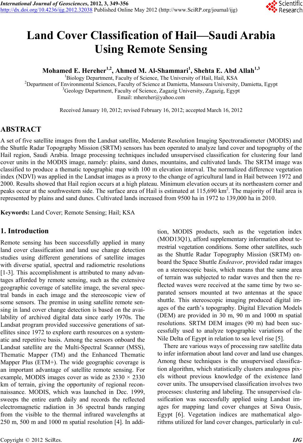
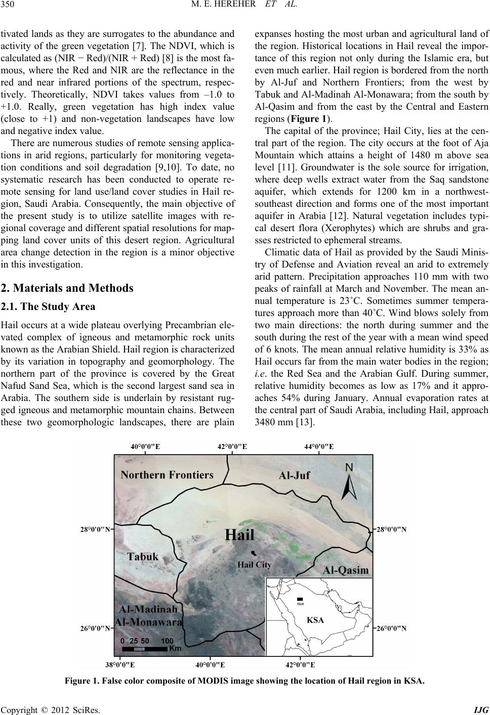
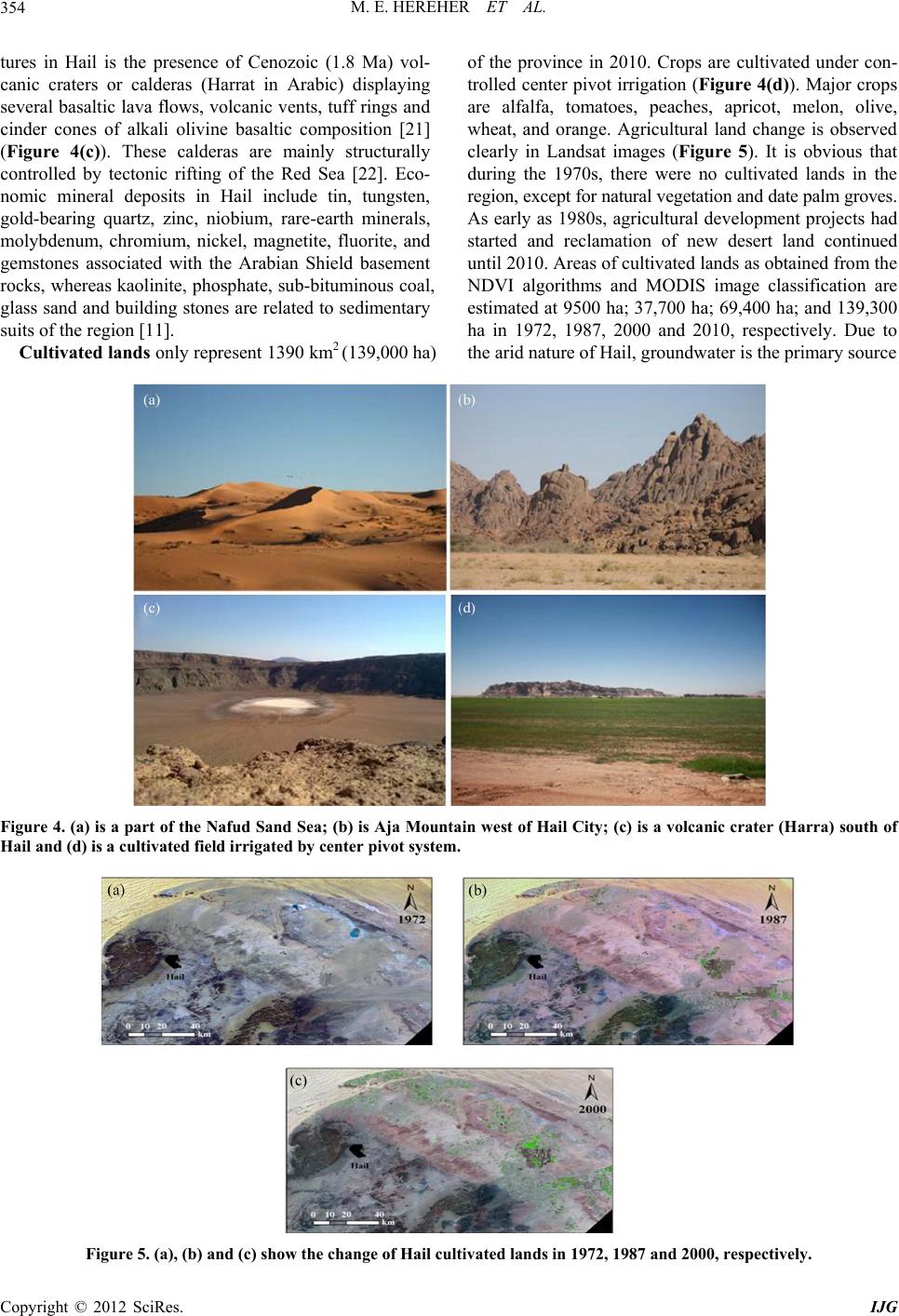
M. E. HEREHER ET AL. 355
for irrigation. Previous studies [23] reported that the Saq
aquifer stores as much as 280,000 million cubic meters of
water reserves with water salinity ranges between 300 -
1000 ppm [24].
4. Conclusion
Hail region has been surveyed from space using different
generations of satellite data. The primary conclusion of
the present study ascertains the importance of using re-
mote sensing for mapping desert geomorphology at a
regional scale. Hail has a promising development future.
The region is rich in economic mineral deposits and has a
significant potentiality for national tourism. As agricul-
ture is significantly growing in this arid region, detailed
hydrogeological studies are needed in terms of its quan-
tity and quality for irrigation. Moreover, the drifting sand
from the northern Nafud Sand Sea entails detailed studies
to recognize their patterns and magnitude of encroach-
ment because they cause series problems to settlements
and infrastructures.
REFERENCES
[1] F. Yuan, K. Sawaya, B. Loeffelholz and M. Bauer, “Land
Cover Classification and Change Analysis of the Twin
Cities (Minnesota) Metropolitan Area by Multitemporal
Landsat Remote Sensing,” Remote Sensing of Environ-
ment, Vol. 98, 2005, pp. 317-328.
doi:10.1016/j.rse.2005.08.006
[2] A. Collado, E. Chuvieco and A. Camarasa, “Satellite
Remote Sensing Analysis to Monitor Desertification Pro-
cesses in the Crop-Rangeland Boundary of Argentina,”
Journal of Arid Environments, Vol. 52, No. 1, 2002, pp.
121-133.
[3] A. Prakash, and R. Gupta, “Land-Use Mapping and Ch-
ange Detection in a Coal Mining Area—A Case Study in
the Jharia Coalfield, India,” International Journal of Re-
mote Sensing, Vol. 19, No. 3, 1998, pp. 391-410.
doi:10.1080/014311698216053
[4] Q. Cheng, “Multisensor Comparisons for Validation of
MODIS Vegetation Indices,” Pedosphere, Vol. 16, No. 3,
2006, pp. 362-370. doi:10.1016/S1002-0160(06)60064-7
[5] M. Hereher, “Vulnerability of the Nile Delta to Sea Level
Rise: An Assessment Using Remote Sensing,” Geomatics,
Natural Hazards and Risk, Vol. 1, No. 4, 2010, pp. 315-
321. doi:10.1080/19475705.2010.516912
[6] A. Masoud and K. Koiki, “Arid Land Salinization De-
tected by Remotely-Sensed Landcover Changes: A Case
Study in the Siwa Region, NW Egypt,” Journal of Arid
Environments, Vol. 66, No. 1, 2006, pp. 151-167.
doi:10.1016/j.jaridenv.2005.10.011
[7] D. Fuller, “Trends in NDVI Time Series and Their Rela-
tion to Rangeland and Crop Production in Senegal, 1987-
1993,” International Journal of Remote Sensing, Vol. 19,
No. 10, 1998, pp. 2013-2018.
doi:10.1080/014311698215135
[8] J. Rouse, R. Has, J. Schell and D. Deering, “Monitoring
Vegetation Systems in the Great Plains with ERTS,” Pro-
ceedings 3rd Earth Resources Technology Satellite-1
Symposium, Greenbelt, NASA SP-351, 1974, pp. 3010-
3017.
[9] E. Weiss, S. E. Marsh and E. S. Pfirman, “Application of
NOAA-AVHRR NDVI Time-Series Data to Assess
Changes in Saudi Arabia’s Rangelands,” International
Journal of Remote Sensing, Vol. 22, No. 6, 2001, pp.
1005-1027. doi:10.1080/014311601300074540
[10] E. Symeonakis and N. Drake, “Monitoring Desertification
and Land Degradation over Sub-Saharan Africa,” Inter-
national Journal of Remote Sensing, Vol. 25, No. 3, 2004,
573-592. doi:10.1080/0143116031000095998
[11] B. Ekren, D. Vaslet, A. Berthiaux, P. Strat and J.
Fourniguet, “Explanatory Notes to the Geologic Map of
the Hail Quadrangle, Sheet 27E, Kingdom of Saudi Ara-
bia,” Deputy Ministry for Mineral Resources, Ministry of
Petroleum and Mineral Resources, Jeddah, 1986, p. 46.
[12] M. Hussein, A. Bazuhair and A. Ageeb, “Hydrogeology
of the Saq Formation East of Hail, Northern Saudi Ara-
bia,” Quaternary Journal of Engineering Geology, Vol.
25, 1992, pp. 57-64.
doi:10.1144/GSL.QJEG.1992.025.01.05
[13] H. Edgell, “Arabian Deserts: Nature, Origin, and Evolu-
tion,” Springer, Dordrecht, 2006.
doi:10.1007/1-4020-3970-0
[14] P. Chavez, “Image-Based Atmospheric Correction-Re-
vised and Improved,” Photogrammetric Engineering and
Remote Sensing, Vol. 62, No. 9, 1996, pp. 1025-1036.
[15] A. Singh, “Digital Change Detection Techniques Using
Remotely-Sensed Data,” International Journal of Remote
Sensing, Vol. 10, No. 6, 1989, pp. 989-1003.
doi:10.1080/01431168908903939
[16] G. Foody, “Status of Land Cover Classification of Accu-
racy Assessment,” Remote Sensing of Environment, Vol.
80, 2002, pp. 185-201.
doi:10.1016/S0034-4257(01)00295-4
[17] C. Tucker, “Red and Photographic Infrared Linear Com-
bination for Monitoring Green Vegetation,” Remote Sen-
sing of Environment, Vol. 8, 1979, pp. 127-150.
doi:10.1016/0034-4257(79)90013-0
[18] A. Al-Laboun, “The Subsurface Stratigraphy of Pre-Khuff
Formations in Central and Northwestern Arabia,” Ph.D.
Thesis, Faculty of Earth Sciences, King Abdulaziz Uni-
versity, Jeddah, 1982.
[19] P. Burek, “Structural Effects of Sea-Floor Spreading in
the Gulf of Aden and the Red Sea on the Arabian Shield,”
In: E. Degens and D. Ross, Eds., Hot Brines and Recent
Heavy Metal Deposits in the Red Sea, Springer-Verlag,
Berlin, 1969, pp. 59-70.
[20] A. Dabbagh, K. Al-Hinai and M. Khan, “Detection of
Sand-Covered Geologic Features in the Arabian Penin-
sula Using SIR-C/X-SAR Data,” Remote Sensing of En-
vironment, Vol. 59, No. 2, 1997, pp. 375-382.
doi:10.1016/S0034-4257(96)00160-5
[21] J. Pallister, “Reconnassance Geology of the Harrat Al
Hutaymah Quadrangle, Sheet 26/42 A, Kingdom of Saudi
Copyright © 2012 SciRes. IJG
M. E. HEREHER ET AL.
356
Arabia,” Saudi Arabian Deputy Ministry for Mineral Re-
sources, Jeddah, 1986, p. 77.
[22] R. Coleman, R. Gregory and G. Brown, “Cenozoic Vol-
canic Rocks of Saudi Arabia,” Saudi Arabian Deputy
Ministry for Mineral Resources, Jeddah, 1983, p. 82.
[23] J. Lloyd and R. Pirn, “The Hydrogeology and Ground-
water Resources Development of the Cambro-Ordovician
Sandstone Aquifer in Saudi Arabia and Jordan,” Journal
of Hydrology, Vol. 121, 1990, pp. 1-20.
doi:10.1016/0022-1694(90)90221-I
[24] M. Sharaf and M. Hussein, “Groundwater Quality in the
Saq Aquifer, Saudi Arabia,” Hydrology Sciences Journal,
Vol. 41, No. 5, 1996, pp. 683-696.
doi:10.1080/02626669609491539
Copyright © 2012 SciRes. IJG