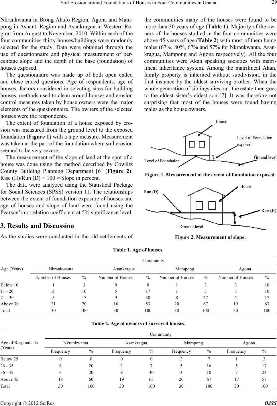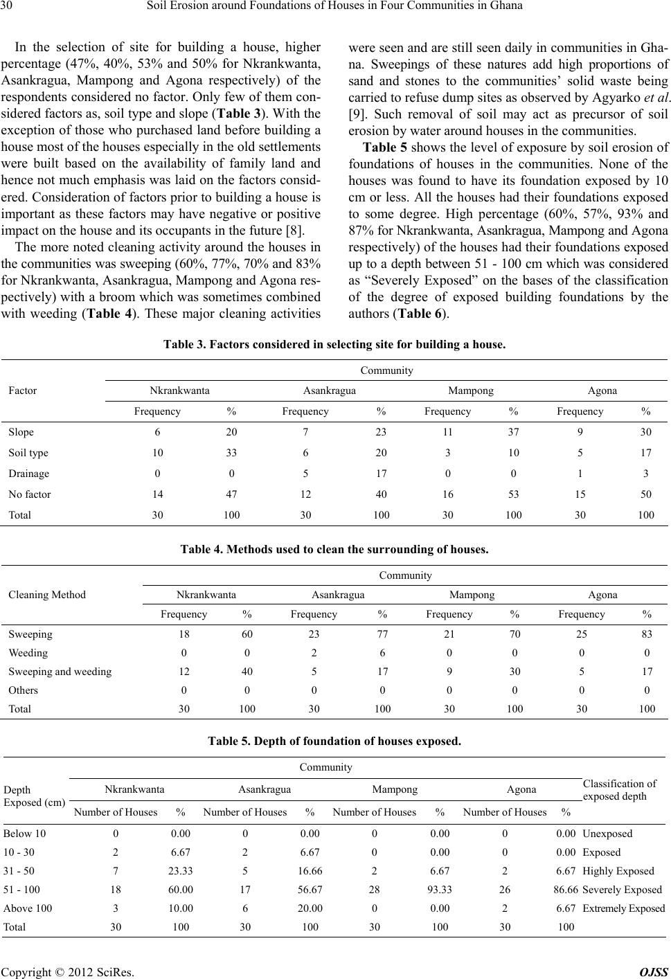
Soil Erosion around Foundations of Houses in Four Communities in Ghana
32
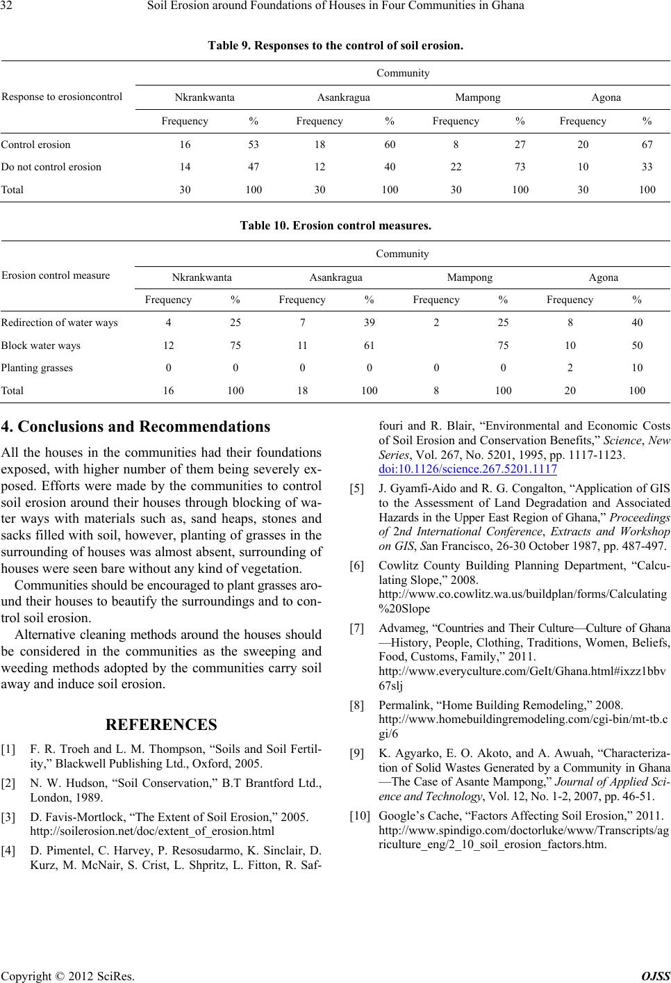
Table 9. Responses to the control of soil erosion.
Community
Nkrankwanta Asankragua Mampong Agona
Response to erosioncontrol
Frequency % Frequency % Frequency % Frequency %
Control erosion 16 53 18 60 8 27 20 67
Do not control erosion 14 47 12 40 22 73 10 33
Total 30 100 30 100 30 100 30 100
Table 10. Erosion control measures.
Community
Nkrankwanta Asankragua Mampong Agona
Erosion control measure
Frequency % Frequency% Frequency% Frequency %
Redirection of water wa ys 4 25 7 39 2 25 8 40
Block water ways 12 75 11 61 75 10 50
Planting grasses 0 0 0 0 0 0 2 10
Total 16 100 18 100 8 100 20 100
4. Conclusions and Recommendations
All the houses in the communities had their foundations
exposed, with higher number of them being severely ex-
posed. Efforts were made by the communities to control
soil erosion around their houses through blocking of wa-
ter ways with materials such as, sand heaps, stones and
sacks filled with soil, however, plantin g of grasses in the
surrounding of houses was almost absent, surrounding of
houses were seen bare without any kind of vegetation.
Communities should be encouraged to plant grasses aro-
und their houses to b eautify the surround ings and to con-
trol soil erosion.
Alternative cleaning methods around the houses should
be considered in the communities as the sweeping and
weeding methods adopted by the communities carry soil
away and induce soil erosion.
REFERENCES
[1] F. R. Troeh and L. M. Thompson, “Soils and Soil Fertil-
ity,” Blackwell Publishing Ltd., Oxford, 2005.
[2] N. W. Hudson, “Soil Conservation,” B.T Brantford Ltd.,
London, 1989.
[3] D. Favis-Mortlock, “The Extent of Soil Erosion,” 2005.
http://soilerosion.net/doc/extent_of_erosion.html
[4] D. Pimentel, C. Harvey, P. Resosudarmo, K. Sinclair, D.
Kurz, M. McNair, S. Crist, L. Shpritz, L. Fitton, R. Saf-
fouri and R. Blair, “Environmental and Economic Costs
of Soil Erosion and Conservation Benefits,” Science, New
Series, Vol. 267, No. 5201, 1995, pp. 1117-1123.
doi:10.1126/science.267.5201.1117
[5] J. Gyamfi-Aido and R. G. Conga lton, “Application of GIS
to the Assessment of Land Degradation and Associated
Hazards in the Upper East Region of Ghana,” Proceedings
of 2nd International Conference, Extracts and Workshop
on GIS, San Francisco, 26-30 October 1987, pp. 487-497.
[6] Cowlitz County Building Planning Department, “Calcu-
lating Slope,” 2008.
http://www.co.cowlitz.wa.us/buildplan/forms/Calculating
%20Slope
[7] Advameg, “Countries and Their Culture—Culture of Ghana
—History, People, Clothing, Traditions, Women, Beliefs,
Food, Customs, Family,” 2011.
http://www.everyculture.com/GeIt/Ghana.html#ixzz1bbv
67slj
[8] Permalink, “Home Building Remodeling,” 2008.
http://www.homebuildingremodeling.com/cgi-bin/mt-tb.c
gi/6
[9] K. Agyarko, E. O. Akoto, and A. Awuah, “Characteriza-
tion of Solid Wastes Generated by a Community in Ghana
—The Case of Asante Mampong,” Journal of Applied Sci -
ence and Technology, Vol. 12, No. 1-2, 2007, pp. 46-51.
[10] Google’s Cache, “Factors Affecting Soil Erosion,” 2011.
http://www.spindigo.com/doctorluke/www/Transcripts/ag
riculture_eng/2_10_soil_erosion_factors.htm.
Copyright © 2012 SciRes. OJSS