Vol.2, No.4, 409-417 (2010) Natural Science
http://dx.doi.org/10.4236/ns.2010.24050
Copyright © 2010 SciRes. OPEN ACCESS
Overview of flooding damages and its destructions: a
case study of Zonguldak-Bartin basin in Turkey
Hasan Arman1,3, Ibrahim Yuksel2*, Lutfi Saltabas3, Fatih Goktepe3, Mehmet Sandalci3
1College of Science, Department of Geology, United Arab Emirates University, Al-Ain, UAE; Harman@uaeu.ac.ae;
harman@sakarya.edu.tr
2Faculty of Technology, Department of Construction, Sakarya University, Esentepe Campus, Sakarya, Turkey;
yukseli2000@yahoo.com; iyuksel@sakarya.edu.tr
3Engineering Faculty Department of Civil Engineering, Sakarya University, Esentepe Campus, Sakarya, Turkey
Received 29 December 2009; revised 26 January 2010; accepted 2 February 2010.
ABSTRACT
A number of devastating flood events have oc-
curred in the various river basins of Turkey in
the last decade. Because floods caused deaths,
suffering and extensive damages to both public
and private properties in the flood areas, the
government had to most of the damage in addi-
tion to losing significant revenues due to the
consequences of costly social and economic
disruption. On the other hand, some social
structures such as socioeconomic activities,
land-use patterns and hydro-morphological
processes are destroyed. Whereas flood control
structures are considered as one of the basic
strategies that can reduce flood damages and in
this context flood protection planning should
consider the full range of the hazard mitigation
activities. In Turkey, between 1945 and 1990, 737
flooding events were occurred and at least 830
people were killed. In 1998, there was a major
flooding in Zonguldak-Bartin region located on
north of Turkey. Due to this devastated flooding,
people lost their life and numbers of engineer-
ing structures built on the river and surrounding
area were totally destroyed or heavily damaged.
Both side of the canal were covered with muddy
soil having 0.10-0.15 m thickness. Cleaning up
process took sometimes in the region. In this
paper, all these subjects have been investigated
in the basin and some engineering proposals
have been presented.
Keywords: Flood Damages; River Management;
Zonguldak-Bartin Basin; Flood Control
1. INTRODUCTION
Beside social, economical, technological, administrative
and political gains during the development from pri-
marily communities to our information communities
throughout the history some hard to solve problems for
the future generations and for us about our environment
had occurred, especially because of industrialization and
urbanization attempts that do not care about environment
in spite of their economical profits. Due to global eco-
nomic order that overbalance the ecosystem, environ-
ment problems, which did not exist in twenty century,
exist in last twenty-five year. Problems like population
increase, decrease in agriculture land area, reduction of
ground water, devastation of forests, disappearing of
plants and animal kinds, air-water-soil pollution, in-
crease of temperature because of greenhouse gases, are
vital for humanity. As a result of this, because of climatic
changes it is expecting that there is a risk of hurricanes,
strong precipitations, or long-term drought, risk of lands
turning into desert [1]. Floods are due to heavy rainfall
on the coastal areas of the western and southern parts of
Turkey or to a sudden increase in air temperature, re-
sulting in snow melt in the eastern, mountainous part of
southeastern Turkey especially Eastern Black Sea Re-
gion [2,3]. In the northern and central parts of the coun-
try both factors may occur depending on the time of the
year.
In Turkey the precipitation types are frontal, oro-
graphic, or convective. During occluded fronts, long
lasting, intense rainfall may produce flooding depending
on the season of the year. Besides most of the coastal
precipitation in the Black Sea region where the range of
mountains runs parallel to the shore sea, considering
some others properties of the region such as hydraulics,
hydrological, meteorological characteristics at least a
few floods have occurred in a year in this region [4,5].
Convective precipitation mostly occurs during the tran-
sition seasons of spring and autumn and affects central
Anatolia. The snow accumulated in the upper reaches of
the drainage basins of Anatolian rivers melts, starting
H. Arman et al. / Natural Science 2 (2010) 409-417
Copyright © 2010 SciRes. OPEN ACCESS
410
from the beginning of February or March, and can cause
flooding in downstream areas of the rivers. When the
general evaluate of the natural balance irregularities
arising at a global scale is made, it can be seen the af-
fecting parameters, which are subject to change, are the
hydraulic and hydrological ones due to their activities in
the river basin. In some areas almost all the waters of the
rivers are used up with in the basin, primarily for the
purpose of irrigation.
Flash floods are a common, but it is not easy to esti-
mate its environmental features. A lack of accurate en-
vironmental data creates much of the uncertainty associ-
ated with flash flooding events. In addition to limiting
the understanding of hydrological processes, human use
and development in a region cause number of problems.
Extreme events often exert a disproportionately large
effect on the environment, for larger than that associated
with the more commonplace typical events, and are
those most associated with hazards to humans [6]. A
major concern with flash flooding is the development
within a very short period of time. Human life and infra-
structures are under a major threat of flash flooding. The
lack of understanding sometimes compounds problems
of flooding, with settlement, road and other structures
inappropriately located and designed relative to the flood
risk [6].
It is a general accepted fact that especially the dams
constructed at a point very close to the shoreline destroy
the natural balance of shoreline by totally changing the
flow regimen and therefore the sediment load in the riv-
ers. This point, according to one point of view consti-
tutes the crossing point of the shorelines management
and the basin management; according to another point
view it constitute the intersection between the two basic
purposes of both approaches is to watch the natural bal-
ance and maintain development. Then, the problem
could easily be solved in case there is sustainable growth.
In order to achieve joint management, it is obvious that a
good monitoring study has to be done and healthy data
must be obtained [7].
In Turkey, it is known that erosion flooding and land
sliding events are widespread due to unconsciously de-
struction of nature, and weathering. In many regions of
our country flooding and land sliding cause death,
wealth loses every year. Although they are not the only
environment problem, it is important to consider about
these, which time-to-time influence the daily life [1].
This paper deal with the effectiveness of river flood-
ing and its destructive damages on human and their
structures built on the river and its surrounding area.
Flooding in the Zonguldak-Bartin region during the
summer of 1998 caused extensive damage. Immediately
after the 1998 floods the Turkish Government took steps
to rescue and remove both people and property from
flooding area and built up a temporary bridge on the
river to provide access people living on both side of the
river.
2. FLOOD INVENTORY AND EXITING
FLOOD MEASURES IN TURKEY
The existing flood related measures carried out in the
framework of flood management can be summarized as:
Structural Projects: Structural projects keep flood
waters away from an area with a levee or reservoir,
or other measure that controls the flow of water.
Hydrometric and Meteorological Observation Works:
In an attempt to determine reverie flood hazard by
catchments area characteristics, such as rainfall and
stream flows.
Survey Reports on Past Floods: State Hydraulic
Works (DSI) has been preparing survey reports soon
after flood events to establish actual flood damage
information and area of inundation. These reports
also include date, time, duration, place, meteorology,
hydrology and hydraulic of each flood event. The
study method is based on field interviews, ques-
tionnaires, observations and flood records. The sur-
vey reports of each year are formed as flood yearly
book by DSI.
Surveys Relating to Land Use Plans: As all settle-
ment and construction areas are subjected to land
use planning permission, DSI carries out flood sur-
veys, which are conveyed to municipalities or gov-
ernmental organizations and institutions for use as
data at the planning stage.
Regional Flood Plans: DSI prepares regional flood
plans that have the basin-wide coverage to be inte-
grated to basin disaster plan for using in the emer-
gency management of the future disasters in the ba-
sin.
Stream bed modification by setting up new diver-
sion structures, dykes and groins.
Reforestation, land improvement.
Education and information.
However, the methods listed above are available and
applied at many places, that does not mean that they are
effective everywhere. And the last item education is rel-
atively short-lived. If no practical proof of the theoreti-
cal information is given, the knowledge and awareness
of the risk will be lost within a few years, even if it was
there at the beginning [8]. As long as human continue to
built any kind of engineering structures such as dams,
highways, bridges, homes and etc. on flood-prone area it
can expect continued loss of lives and property. Factors
that control the damage cause by floods include:
Land use on the floodplain,
H. Arman et al. / Natural Science 2 (2010) 409-417
Copyright © 2010 SciRes. OPEN ACCESS
411
Magnitude (depth and velocity of the water and fre-
quency of flooding),
Rate of rise and duration of flooding,
Season (for example: crops on floodplain),
Sediment load deposited,
Effectiveness of forecasting, warning emergency
systems [9].
Primary effects include injury and loss of life, along
with damage caused by swift currents, debris and
sediment to farms, homes, buildings, railroads, bridges,
roads and communication systems. Erosion and depo-
sition of sediment in the rural and urban landscape can
also involve a loss of considerable soil and vegetation.
Secondary effects can include short-term pollution of
rivers, hunger and disease and displacement of people
who have lost their home. In addition, fire may be
caused by short circuits or broke gas mains [9]. Rela-
tionships between land use and flooding of small
drainage basin may be quite complex. Use of agricul-
tural land may affect the flooding. Urbanization is not
the only type of development that can increase flood-
ing [9]. Land cover has a strong influence on key hy-
drological variables such as infiltration and evapora-
tion [6].
3. FLOOD AND WATER MANAGEMENT
3.1. The Use of Floodplain and
Floodwaters along the Rivers
In the some basin at urban area, flood plains along the
rivers crossing cities and towns are used for car parking,
recreational purpose and for sporting activities, but at
rural areas, the flood plains are used for agricultural or
others purpose. The farmers cultivate at their own plots
as before the land acquisition, but if the flood occurs,
with the help of local legal people, sue the state for re-
payment. The flood waters are not used under any cir-
cumstances; the local people and authorities try to get rid
of the water as quickly as possible [8].
3.2. Flood Warning System
Experiences gained from the floods of last decade show
that structural measures implemented in the basin-wide
are effective but too costly in reducing the risk of flood
damages. In this respect, it has been considered that
more importance should be given to non-structural
measures, particularly modification of traditional land
use and updating building code guidelines and design
standards, early flood warning system, creation of public
awareness, insurance and timely and effective emer-
gency management, in order to be more effective for
integrated flood management in the project area and in
the whole country. Due to economic limitations, non-
structural measures imposed by the local municipalities
are not always successful. Because the local municipal-
ity authorities had to receive the money from central
government for the realization of the infrastructures,
for example their budget can not cover the land use
modification projects. Briefly, the existing non-struc-
tural measures are not always successful because of two
main reasons [8]:
In the present situation, the non-structural meas-
ures are mostly dealt with by the local administra-
tions including municipalities and mayors. How-
ever, due to the present economic conditions, the
implementations of the needed activities by these
bodies are limited.
The local units do not have enough educated and
trained personnel to implement the nonstructural
measures.
On the other hand, in Turkey, local non-Government
Organizations (NGOs) are themselves at developing
stage. The other point is that the development stage of
local non-governmental organizations (NGOs) is not yet
satisfactory in dealing with flood disasters.
3.3. Modification in Flood Mitigation
Within the framework of flood management, with the
increase of structural measures, it is true that the occur-
rences of floods and their damages become less in Tur-
key. However, in the recent years, the more importance
is given to the non-structural measures, in a given com-
prehensive plan, including the arrangement of the human
activities, the education of the people and the informing
of the stakeholders.
From the last experiences, it is understood that the
most of the damages is directly related to the fact that
the irregular and uncontrolled urbanization at the
high-risk areas in the flood plains. In this regard, this
approach gives the more responsibility to the local
governments and municipalities. There are also some
mitigation activities done during the flooding events.
These are mostly related to rescue works and emergency
studies.
4. FLOOD AND WATER MANAGEMENT
INSTRUMENTS
4.1. Existing Laws Related to Integrated
Flood Mitigation Concept
The basic legislation in water sector is the Turkish Con-
stitution, which states that water resources are natural
wealth of the country, and under the authority of the
State, to be used for the benefit of public. In this direc-
tion, the Turkish Civil Code covers water both common
waters and private waters. The Red Crescent does the
first aid, and the General Directorate of Disaster Affairs
H. Arman et al. / Natural Science 2 (2010) 409-417
Copyright © 2010 SciRes. OPEN ACCESS
412
Figure 1. The flow chart in Turkish disaster management sys-
tem.
(AFET) does the flood mitigation work. With existing
laws, the following State organizations deal with the
integrated flood management (Figure 1).
According to The Republic of Turkey laws:
DSI is responsible to prevent the disaster effects of
both surface and groundwater; and to build protec-
tive structures against the floods, and get benefits
from its beneficiary uses,
State Meteorological Institute (DMI) is responsible
to supply the meteorological support to the sectors
of agriculture, forestry, tourism, transportation, en-
ergy, health, and environment, military; on the other
hand all kinds of climatic data are collected by DMI
during floods,
The law of General Directorate of Rural Affairs
(KHGM) states has to prepare and apply some ser-
vice and investment programs for the requirements
of farmers in the rural areas in order to protect, de-
velop and effective use of water and land resources
in compliance with the politics and principals de-
termined in the development plan and program. To
reclaim the unsuitable land areas for agriculture,
belong to the state or private; to prepare the needed
reclamation projects for these areas to establish
co-operations for the activities of soil conservation,
land reclamation and irrigation.
Laws of Bank of Provinces (IB) and municipalities
also states the responsibility of local organizations have
to fight against the all natural disasters faced at the re-
gion under consideration, IB provides the funds and
Municipalities spend it properly [8].
4.2. Enforcement of the Laws
The enforcement is realized by the close cooperation of
the central government at capital city; and the govern-
ment’s top level representative at the provinces; where
the flood disaster is encountered. The basic steps are the
first aid, evacuation, safety, and shelter, normalization
of the daily routines, rebuilding and recovery of local
economy.
When a natural disaster like flood is encountered in a
city, then the governor is top decision maker. The experts
from various state organizations and mayor and army
representatives help the governor to shape up the final
decision. This expert group forms are called as “Crises
Table (CT)”. CT includes deputy governors, mayor, local
army commander, the local representatives of DMI, DSI,
State Highway Department (TCK), KHGM, civil de-
fense, red crescent, fire brigade and other local non-
overnmental organizations, like farmers union, trade
union, chamber of commerce etc. In case of flood disas-
ters, DSI and DMI local representatives play the most
important role in decision-making [8].
5. COOPERATION FOR FLOOD
MANAGEMENT
There should be a good and effective cooperation among
the responsible institutes and local interest groups for
flood management. A number of governmental and non-
governmental organizations have direct and indirect re-
sponsibility in integrated disaster management of floods
in Turkey. AFET, General Directorate of Civil Defense,
Army, Local Administrations and Municipalities. Institu-
tional framework has three levels; namely, decision
making, executive and users level. DSI is authorized to
plan and manage all aspects and issues of flood man-
agement especially after the flood event.
In the long run, all the rehabilitation works are
planned and realized by the state, but during the plan-
ning stage, all the local interest groups express their
views freely. At this stage, local parliamentarians and
administrations play the most effective role on deciding
the priorities. When a flood disaster is encountered at a
province, according to the existing laws, written rules
and regulations defining the responsibilities of each or-
ganization in emergency case, legislation, administrative
principles, hierarchy and the local traditions, Emergency
Aid Organizations and Programs Related to Disaster
Management initiated the following points:
Pre-disaster planning,
Set up some units of the different services in cities
for disaster management,
Set up other special service units and related details.
Generally, there are written rules and regulations de-
fining the responsibilities of each organization in emer-
gency case, but due to human factor, just after the disas-
ter, there may be always chaos, but soon it is over and
the system starts to work properly [8]. Of course there
some local interest groups or organizations, which are
Non-Governmental Organizations (NGOs) such as the
H. Arman et al. / Natural Science 2 (2010) 409-417
Copyright © 2010 SciRes. OPEN ACCESS
413
unions of farmers, merchants, businessmen, and cham-
ber of commerce. Elected representatives of the local
people, mayor, helps to shape up the local public mind to
deal with the similar type of floods in future. There may
be economic help from the banks, rich local people,
some nationwide campaigns to help the disaster hit area
but usually these types of helps come afterwards and not
sure. There are no written rules to define the type of the
service the NGOs are expected to give, but their service
is voluntary. So the state is the main healer and organizer
of the helps.
6. SOME FLOODS AND LANDSLIDES
OCCURRED IN TURKEY
Result of devastation of nature, we have been facing
flooding, landslides which causes life and property loses
over 80-years period of time. In 1910, it is recorded that
after a large rainfall, Tokat-Behzat Stream overflows its
blanks and flow over a barrack and cause 2000 people to
die in one night. Our country face with 737-flood events
during 1945-1990 and has lost 838 people. In 1957, An-
kara-Hatip creek flooded and 185 people were died.
In 1998 Macka-Catlak landslide is caused 65 deaths
[10]. In Rize City, the maximum rainfall recorded as
4045.3 mm/year in 1931, and in Igdır the minimum
rainfall recorded as 114.5 mm/year in 1970 [11]. These
given examples are the ones, which cause the most death
in near history. This does not mean that flooding and
landsliding do not cause life loss nowadays. Recently,
after a heavy rainfall, number of life or properties loses
can occur in many region of our country. However, it is
good to say that lost of lives minimized with the gained
experiences from past events. On the other hand, it is not
possible to say same thing for properties loss.
6.1. Study Area: Zonguldak-Bartin Basin
Zonguldak-Bartin region is located on north of Turkey.
In 1998, there was a major flooding in the region (Fig-
ure 2). Due to this devastated flooding, people lost their
life and numbers of engineering structures built on the
river and surrounding area were totally destroyed or
heavily damaged. The damages caused by flooding may
be classified in four categories as follows:
Heavy damages in both side of river bed and its
surrounding areas such as interstate and intercity
highways (Figure 3).
Destructive damages on bridge which connect both
side of river (Figure 4).
Totally and slight damaged buildings (Figure 5).
Localized landsliding phenomena (Figure 6).
Both side of the canal were covered with muddy soil
having 0.10-0.15 m thickness (Figure 1). This thick-
ness reaches more than 0.50 m in some locations spe-
cifically near the riverbed (Figure 3). River water rose
approximately 3.00 m during flooding. Then, cleaning
up process took sometimes in the region.
BARTIN
0 35 70 km
BLACK SEA
Current Level Recorder in Operation
Current Level Recorder Closed Operation
Lake Level Recorder Closed Operation
L Water stage recorder
Lake Level Recorder in Operation
T Cablewa
y
measurement
D DSI water stage recorder
Watershed border
Figure 2. The case study area.
H. Arman et al. / Natural Science 2 (2010) 409-417
Copyright © 2010 SciRes. OPEN ACCESS
414
Figure 3. Intensive damages occurred in riverbed [1].
Figure 4. One of the totally damaged bridges [1].
7. RELATION BETWEEN EROSION,
FLOODING AND HEAVY PRECIPITATION
In world, 25-billion tons of earth loses through erosion
in every year. In the other word, 0.5-2.0 tons of one-
hectare earth loses in each year. In last fifteen years, ag-
ricultural terrain/person rate decreases 14.3% in devel-
oped countries and 40% in developing countries. If this
decreasing tendency goes on this rate will decrease by
50% in 2050 [10]. Erosion is one of the most important
problems of the world. According to United Nations
Environment Program (UNAP), 25% of the world terrain
and 900 million people effect from erosion. World soil
loss through erosion is 480 billion ton in last 20 years.
H. Arman et al. / Natural Science 2 (2010) 409-417
Copyright © 2010 SciRes. OPEN ACCESS
415
Figure 5. Totally destroyed buildings along the riverside [1].
Figure 6. Landslides occurred at some location along the riverbed [1].
Turkey is under erosion condition that all type and in-
tensity of erosion can be seen. Therefore, our country
loses 500 million tons of soil, which is enough to fill
150000 trucks, and can cover Sakarya City with a 29 cm
thick stratum [12]. 86% of our country soils face with
erosion danger [13]. In our country, the dragging mate-
rial amount in riverbeds is 600 million ton. This is 1.8
times the all Europe’s related value, 320 million ton [14].
Erosion or soil weathering is a break down in nature
balance occurs with loss of forests and pastures in slopes.
After erosion, in erosion zone, it can be seen that water
balance changes and (after a rain, by the incoming water
from slopes and creeks) there can be floods if the geo-
logical structure and other factors are appropriate.
By weathering, soil loses its upper (organic) strata,
which is rich in organic materials and fragmental, big
pores occur by the effect of this organic material. This
upper stratum absorbs much of the rainwater as a sponge
so flowing rainwater decreases, by lose of this upper
strata approximately all rainwater flows along the sur-
face and in this condition floodplains occur [11]. Be-
cause of being in a crossing zone as a geographical loca-
H. Arman et al. / Natural Science 2 (2010) 409-417
Copyright © 2010 SciRes. OPEN ACCESS
416
tion, the half zone climate conditions are dominant.
Therefore, majority of precipitations are in short or long
time which causes erosion. Although the mean rainfall is
643 mm for Turkey, it is possible to see (according to
time and location) rainfall values like 220 mm or
2500 mm as in eastern Black Sea region of Turkey. In
inner and eastern region, rainfall mean is less than
400 mm. Between October-January, period that is im-
portant for agriculture; rainfall mean was 313.9 mm ear-
lier, this mean decreased to 249.4 mm by 23.8% lose in
October 1999-January 2000 period and to 190.1 mm by
39.5% lose in October 2000-January 2001 period [10].
Turkey is not a rich country in water resources. If
this decreasing tendency goes on, today’s water am-
ount, which is 2860 m3/person/year, will decrease to
1240 m3/person/year in 2050 and 700 m3/person/year in
2100. 2/3 of rainfall dropped on the earth surface starts
flooding [10].
8. RECENT CHANGES IN THE FLOOD
MANAGEMENT
The floods of the last decade, with their costly results
have brought Turkey to a new view-point to reduce and
control the susceptibility to the flood damages, namely
the “Integrated Flood Management”. In this context, a
sound underwriting for land use control, flood insurance
and early warning system are being considered. It can be
said that from the years of experiences gained showed
structural measures such as dams, levees and dykes, di-
versions, channel improvements, implemented in the
basin-wide were effective with rather high cost, to re-
duce the risk in flood damage. Therefore non-structural
measures are becoming more important in flood hazard
management in the country.
9. CONCLUSIONS AND SUGGESTIONS
Devastation of forests and because of this loses of pas-
tures and plants are fundamental reason for erosion.
Then, extensive damages will occur due to flooding and
land sliding. The biggest damage caused by erosion is
losing the fruitful earth, which formed by thousand year
periods. In order to evaluate the important of this, it as-
sists that thinking a tree can produce a benefit, which is
2000 times its wood profit. Erosion is an important rea-
son for agricultural production. Due to erosion and un-
suitable use of agricultural terrains, decreasing agricul-
tural terrains become insufficient to rapidly growing
population so migration from villages to cities acceler-
ates. The dams and other flood control structures played
very important role in protecting the human life. How-
ever, flood control and management based on structural
solutions could be insufficient. Therefore, effective solu-
tions based on land use control, zoning, building ordi-
nance, modifications in building codes, flood informa-
tion programs by local communities are needed. This
required major restructuring of both present legal sys-
tems and institutions responsible for management.
The flood plain use along the narrow valleys, encour-
aged by local civil administrations, had to be put under
control. Otherwise, future human loss will be greater.
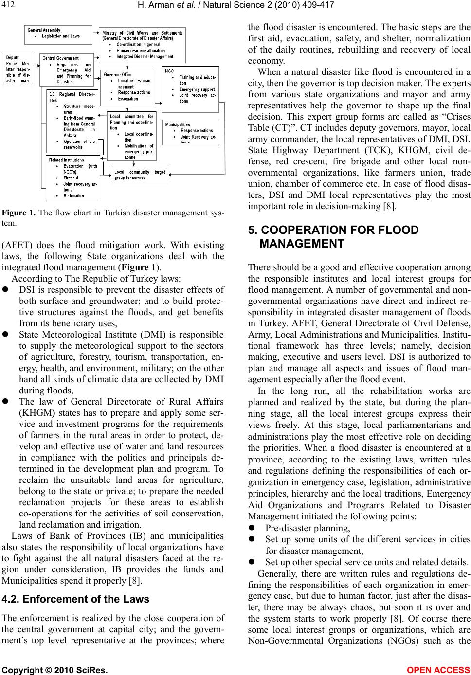
During a flood, prior to all the state organizations should
cooperate. In this respect, DSI, General Directorate of
Electric Power Resources Survey and Administration
(EIE) and DMI should be able to work together. From
the view point of flood, considering the old experiences,
to decrease of the flood damages or to take under control
the flood some suggestions proposed for countries espe-
cially developing countries would be as follows:
They should improve early warning system,
They should prepare hazard mitigation plans and
strategies and,
They should be supplied with scientific and techni-
cal information about the flood.
REFERENCES
[1] Arman, H. (2004) Overview of flooding damages and its
destructive consequences in Turkey: A case study of
Zonguldak-Bartin flooding in 1998, Turkey. NATO Ad-
vanced Research Workshop, Ostrov u Tise.
[2] Yuksel, I. (2003) River erosion in eastern Black Sea re-
gion and scientific approaches aimed to prevent those
events. Journal of Engineering Bulletin, Chamber of
Civil Engineering, Trabzon Division, 17(62), 8-9.
[3] Yuksel, I., Onsoy, H. and Yuksek, O. (2005) Analyzing of
river and coastal erosions based on the characteristics
properties of the eastern Black Sea. 5th Nationally
Coastal Engineering Symposium, Bodrum, 5-7 May 2005,
75-87.
[4] Yuksel, I. and Yuksek, O. (2003) Analysis of erosion in
eastern Black Sea region with the latest developments.
Journal of Natural and Human, 37(2 ), 2-8.
[5] Yuksel, I. and Yuksek, O. (2004) Studying to prevent of
the flood in the settling and agricultural areas in the east-
ern Black Sea region. Journal of Natural and Human,
38(3-4), 64-67.
[6] Foody, M.G., Ghoneim, M.E. and Arnell, W.N. (2004)
Predicting locations sensitive to flash flooding in an arid
environment. Journal of Hydrology, 292(1), 48-58.
[7] Seker, D.Z., Goksel, C., Kabdaslı, S., Musaoglu, N. and
Kaya, S. (2003) Investigation of coastal morphological
changes due to river basin characteristics by means of
remote sensing and GIS techniques. Journal of Water
Science Technology, 48(10), 135-142.
[8] Gurer, I. and Ozguler, H. (2004) Integrated flood man-
agement case study1 Turkey: Recent flood disasters in
northwestern Black Sea region. World Meteorological
Organization, the Associated Programme on Flood Man-
agement.
[9] Keller, E.A. (2000) Environmental geology. 8th Edition,
Prentice-Hall, Inc., New Jersey.
H. Arman et al. / Natural Science 2 (2010) 409-417
Copyright © 2010 SciRes. OPEN ACCESS
417
[10] Gunay, T. (1997) Forest, Unforestation Soil Erosion. The
Turkish Foundation for Computing Soil Erosion for Re-
forestation and the Protection of Natural Habitats
(TEMA), Istanbul.
[11] http://www.meteor.gov.tr (accessible 2008).
[12] http://www.tema.org.tr (accessible 2008).
[13] http://www.agm.gov.tr (accessible 2008).
[14] Burak, S., Duranyildiz, I. and Yetis, U. (1997) National
environmental action plan: Management of water re-
sources. State Planning Organization (DPT), Ankara.