 Engineering, 2010, 2, 270-289 doi:10.4236/eng.2010.24037 Published Online April 2010 (http://www. SciRP.org/journal/eng) Copyright © 2010 SciRes. ENG A Framework for Intelligent Decision Support System for Traffic Congestion Management System Mohamad K. Hasan Department of Quantitative Methods and Information Systems College of Business Administration, Kuwait University, Kuwait city, Kuwait E-mail: mkamal@cba.edu.kw Received November 18, 2009; revised January 22, 2010; accepted February 4, 2010 Abstract Traffic congestion problem is one of the major problems that face many transportation decision makers for urban areas. The problem has many impacts on social, economical and development aspects of urban areas. Hence the solution to this problem is not straight forward. It requires a lot of effort, expertise, time and cost that sometime are not available. Most of the existing transportation planning software, specially the most advanced ones, requires personnel with lots practical transportation planning experience and with high level of education and training. In this paper we propose a comprehensive framework for an Intelligent Decision Support System (IDSS) for Traffic Congestion Management System that utilizes a state of the art transporta- tion network equilibrium modeling and providing an easy to use GIS-based interaction environment. The developed IDSS reduces the dependability on the expertise and level of education of the transportation plan- ners, transportation engineers, or any transportation decision makers. Keywords: Traffic Congestion Management System; Transportation System Management; Intelligent Decision Support System; Urban Transportation Systems Analysis; Multiclass Simultaneous Transportation Equilibrium Models; Intelligent Scenario Creation Assistance Agent 1. Introduction Over the last few decades the dimensions of the trans- portation system and the interaction between these di- mensions and the socioeconomic system, have increased by many folds. And despite the fact that significant ad- vancements have occurred in Information and Commu- nication Technologies (ICT)-based transportation sys- tems and many network equilibrium models have been developed, comprehending this dynamic environment, identifying its critical issues, and responding to them by selecting the right alternative at the right time is still an immensely demanding and difficult task to accomplish even for well trained and experienced transportation ex- pertise. Urban transport problem can be understood in relation to land use and other socio-economic activities which the transportation network serves. A relationship exists be- tween trip frequencies and socioeconomic characterris- tics of trip makers and the purpose for which the trip is made (such as journey to work, to school, to shopping, to social activities, etc. Each of these types of trips is spa- tially distributed over the city between the residential areas and places of interest and activities. Trip purposes, also influence the volume of trip generation in various land use in the city [1]. This is because the volume of journeys made from origin to destination is functionally related to the ability of respective areas to generate or attract movement. Reasons such as inadequate transport infrastructure, rapid increase in urban population, income and automobile ownership etc., had been noted to con- tribute to traffic congestion in many of the urban areas [2]. Traffic congestion is a critical problem in urban ar- eas. It is not always fruitful to expand the transportation systems, if the demand is not satisfactorily met by the existing capacity. As such it is prudent to optimize the use of existing transportation system by certain man- agement techniques. Gazis [3] proposed a way to control closely spaced and oversaturated intersections. Gordon [4] suggested that an intersection control scheme should be aimed at controlling the relative queue lengths on the phases. Longley [5] identified two types of congestion and pro- posed a signal control and queue management procedure that aims at reducing secondary congestion. Pignataro et al. [6] described a queue management procedure. Gartner  M. K. HASAN.271 et al. [7] presented a procedure with multi-level design for real time, traffic-adaptive control. Other work on queue management appeared in the literature [8-10]. Reddy et al. [11], Reddy [12], described the Transporta- tion System Management (TSM) actions to improve ve- hicular movements with the help of a case study. Thom- son [13] described the traffic management problem faced by highly urbanized cities of developing world due to the rapid urbanization relating to traffic congestion. This effort at reducing traffic congestion without providing for more road capacity is expected to shift the trip pattern of motorists in various ways, notably to redistribute trips spatially, temporarily, and modally. Other studies on urban traffic management emanating from non commis- sioned studies include that of Adefolalu [14], on traffic congestion in the city of Lagos; Oyefesobi [15] on acci- dent reduction: Orioke [16], on traffic education: Ogun- bondede [1], on the contribution of land use to traffic congestion. These above studies show that traffic congestion problem is a common phenomenon in urban and part of TSM actions to improve the existing transportation sys- tem for the better serviceability and efficiency by taking various measures. Transportation Systems Management (TSM) measures, originally conceived as a tool applica- ble on a region-wide scale, can be successfully applied at major activity centers to avoid, minimize or postpone the need for more capital-intensive transportation improve- ments [17]. A transportation management system (TSM) is intended to provide information on transportation sys- tem performance and identify alternative actions to alle- viate congested roadway conditions. Although a TSM can use data obtained from a traffic operation surveil- lance and control system, in general a TSM is considered to be more a planning tool than an operations tool [18]. The main objectives of TSM actions are to coordinate all individual elements of transportation systems through operating, regulatory and control policies, so as to achieve the maximum efficiency and productivity and minimize environmental pollution and energy consumption. TSM actions, whether applied on a corridor or at city network level, aim at maximizing the expected output of the transportation systems as whole and achieve the specific objectives [11]. TSM actions include: Assuring the safety and the efficiency flow of pas- senger vehicles and trucks along urban and rural transportation networks [19]. Choosing the most efficient improving alterna- tives solutions of the existing transportation system problem at a minimum cost [19]. Increasing the transit system ridership by increasing the frequency of buses or trains, reducing the fair, and assuring scheduling time accuracy. Minimizing the air pollution, noisy, and all others undesirable environmental impacts of the existing transportation system [19] Banning of particular class of vehicles at certain times/certain areas. Auto free zones where vehicles are totally prohib- ited. Special bus lanes and streets where spaces are re- served for public buses and emergency vehicles and other improvements of facilities for buses viz. bus bays and bus stops. Fiscal measures like parking fee, road pricing and supplementary licensing etc. which in turn make the less vehicle usage. Parking Control Staggering of office hours Car pooling Travel Bonus Controlled Entry Banned turns Geometric improvements Improvements for slow moving traffic Improvements to pedestrian facilities Improvements in intersection circulation Synchronization and redesign of signals Detailed benefits of the TSM Program can be found in [19]. To evolve TSM action plan for the selected corridor there is a need to understand and analyze the characteris- tics of traffic flow as well as existing transit system, land use development which generates the traffic on this cor- ridor and their ill effects. To integrate the entire above feature of TSM, we first defined Congestion Management System (CMS) and Intelligent Decision Support System (IDSS). A Congestion Management System (CMS) is a sys- tematic process of monitoring, measuring, and diagnos- ing the causes of current and future congestion in major travel corridors [20]; performing a detailed evaluation analysis and recommendations for different alternatives solutions strategies that can be implemented to improve management of current and future congestion [20]; and monitoring and evaluating the performance of strategies that have been implemented to manage or mitigate con- gestion [21]. US Federal transportation legislation re- quires Metropolitan Planning Organizations (MPO) to develop and implement a CMS as part of the metropoli- tan transportation planning process [22]. The CMS pro- vides a consistent basis to make transportation invest- ment decisions and ensures that travel demand manage- ment (TDM) and transportation system management (TSM) measures are considered prior to roadway capac- ity expansion, in accordance with goals and objectives established by any Metropolitan Planning Organization [20]. The MPO is a transportation policy-making organi- zation made up of representatives from local government and transportation authorities. The dynamic and complex nature of transportation en- Copyright © 2010 SciRes. ENG  M. K. HASAN. 272 vironment, the complexity of the current transportation system and difficulty to comprehend the network equi- librium models and the limited availability of transporta- tion expertise together created an extremely hard envi- ronment to deal with efficiently and effectively. How- ever, the advancement and availability of intelligent agent-based technologies and solutions for integration within a comprehensive transportation system analysis framework, as a Traffic Congestion Management System (TCMS), provide promising solutions. Ossowski et al. [23] summarized good literatures ab- out the Decision Support Systems that include previous works of French [24], Silver [25], Klein and Methlie [26], Hernandez and Serrano [27], Hernandez and Serrano [28], Vlahavas et al. [29], Cuena and Ossowski [30], Ossowski et al. [31], Iglesias et al. [32], and Hoa Dam and Winikoff [33]. More details about the decision support system fun- damentals and the classification of decision support sys- tems can be found in Holsapple [34]. Recently, Zhang [35] addressed the requirements for an open and standardized environment for integrating various DSSs. He also addressed the emergence of intel- ligent agent technology to fulfill the requirements of de- veloping innovative and efficient DSS applications. In his thesis he gave detailed illustrations of the intelligent agents in offering various advantages, such as mobility, flexibility, intelligence, etc., to overcome the major pro- blems in existing DSSs. Creating an intelligent agent-based DSS for TCMS that would enable and assist the transportation system users (operators) to identify critical transportation prob- lem issues and to respond to them by selecting the right course of action in a timely, efficient and effective man- ner would be a response to this critical requirement. To this end, the objective of this paper is to provide such a framework. The main objective of this research paper is to develop A Framework for Intelligent Decision Support System for Traffic Congestion Management System, using state of the art developments in urban transportation system modeling, that can be a useful decision support tool for transportation planners and decision makers for the analysis and evaluation of strategic transportation plans include transportation projects and policies. The main contribution of this research is the creation of Scenario Management Subsystem (SMS) and the In- telligent Scenario Creation Assistance Agent (ISCAA) briefly discussed in Section 4.5 and Section 4.6 respec- tively. We will also show how these components are integrated with the impact models results where the in- puts to these impact models are the result of the Multi- class Simultaneous Transportation Equilibrium Model (MSTEM) [36] that will be run for each transportation alternative solution. And finally, we have an intelligent DSS that can recognize a pattern of solution alternatives for traffic congestion problem associated with its total evaluation. This IDSS can be used by any non- transportation specialist decision makers for any trans- portation policy evaluations and recommendations. This paper is organized as follow: Section 2 gives the main concept for the transportation systems analysis. Section 3 presents a more detailed framework for trans- portation system analysis combing the concept of the transportation planning process and the transportation system analysis concept. Section 3 presents The Multi- class Simultaneous Transportation Equilibrium Model (MSTEM)’s description, formulation as Variational Ine- quality (VI) and the data collection requirements. Section 4 illustrates the main Architecture of the Intelligent De- cision Support System (IDSS) implementing the frame- work for transportation system analysis described in Sec- tion 2. And finally, the summary, conclusion and future research are presented in Section 5. 2. Transportation Systems Analysis 2.1. Transportation System We briefly define the transportation planning as a con- tinuous process consists of: 1) Problem definition, Generation of Alternatives 2) Building and Calibration of Transportation Models 3) Application of the Calibrated Transportation Mod- els and Analysis of Alternatives 4) Evaluation and Choice 5) Implementation A transportation system can be define as the combina- tion of elements and their interactions, which produce the demand for travel within a given area and the supply of the transportation service to satisfy this demand. This definition is general and flexible enough to be applied to different context. The specific structure of the system is defined by the problem itself (or class of problem) for whose solution is employed. Almost all of the components of a social and economic system in a given geographical area interact with diff- erent levels of intensity. However, it is practically im- possible to take into account every interacting element to solve a transportation problem. The typical system ap- proach is to isolate the most relevant element in the problem. These elements, and the relation among them, make up the analysis system. The remaining elements which belong to the external environment are taken into account only in term of their interaction with the analysis system. The transportation system of a given area can also be seen as a sub-system of a wider territorial system with which it strongly interacts. The extent, to which these interactions are included in the analysis system, or in the external environment, depends on the specific problem. Copyright © 2010 SciRes. ENG  M. K. HASAN.273 Transportation is the process of transferring people, good and information from one place to another. To per- form its function, any transportation system consists of several components which together act as a single unit that is designed and developed to provide a suitable technology for the “objects” to be transported. Any transport technology must provide mobility, con- trol, protection, and land access for the objects. Perhaps the most widespread transport technology is the one used for inland transport. That is vehicles and containers op- erating on highway or railway networks. Components of such a transport system may be di- vided into two categories. The first category includes the physical components such as the network infrastructural fixed elements (i.e., road and rail links, intersections, terminals, parking spaces, railway yards, maintenance shops, stations, etc.), and moving elements (i.e., vehicles and containers). The second category includes the human components such as users, operators, owners, and regu- lators of the system, government and the society at large. The key players in system analysis are defined as fol- lows: 1) Users: are those traveler and shipper who represent demand on the transport system. 2) Operators: are those who own the fleet of vehicles and hence, are responsible for their operation, mainte- nance and investment. 3) Owners: are those who own the network elements and hence, are concerned with construction, upgrading, operation and maintenance of the infrastructure. 4) Regulators: are responsible for traffic laws, ordi- nances and regulations. 5) Government: is responsible for creating the master plan for the city transportation systems and policies or projects that affect the transportation systems. 6) Society at large: is responsible location of residents and activities It should be emphasized that these components should interact all together in order to provide effective and ef- ficient “transportation”. Furthermore, a transport system may be viewed as one of several components of more complex socio-economic system of the society. The inter- action between the transport system and its surrounding socio-economic environment is, again, evident. Transport demand is a function of the magnitude and spatial distri- bution of socio-economic activities which in turn are greatly influenced by the characteristics of transport sys- tems. Therefore, the actual performance of any transport system is a function of several interacting and interde- pendent factors within the system and those outside the system. Like any other complex system, transport system may not always perform as desired and there are often prob- lems and issues to be addressed and resolved. Traffic congestion, limited parking space, high accident rate, weak connectivity between major development centers, freight movements, public transit, and air pollution are but a few examples to mention. The range of possible remedies is enormous. Construction of new highways, building multistory garages, introducing new transport technologies, creating new organizational structures and traffic regulations are examples of actions which would be undertaken. The “best” action (or set of actions) to be implemented in particular situation, is a question that is, often, not a simple one to resolve immediately and usually requires a systematic process of analysis that takes into considera- tion the interacting affects on the system, that is, trans- portation planning. Formally defined, planning is “a sys- tematic analytical process that assists decision makers of a given system to achieve a specific set of goals and ob- jectives within a given socio-economic environment in an optimum fashion”. 2.2. Basic Premises As indicated earlier any transport system consists of sev- eral physical as well as human components which inter- act together in order to produce “transportation”. The transport system itself is, again, one of several compo- nents in the socio-economic activity system of the soci- ety when all interact produce what we call the “devel- opment” of that society. Therefore, the analysis of trans- portation systems should be based on two basic prem- ises: 1) The total transport system within a given socio- economic environment must be considered and viewed as a single multimodal system. 2) The interaction between the total transport system and the surrounding socio-economic activity system must be taken into account in the analysis. 2.3. Basic Variables and Relationships Based on the above premises, the resultant effect of the interactions between the activity and transport systems is manifested in the flow pattern distributed on the different elements of the transport system. Therefore, we can de- fine three basic variables for the analysis: T: The Transport System, A: The Activity System F: The Flow Pattern The interrelationships among these three variables are shown on Figure 1 and may be described as follows: Relationship I: T and A determines F Relationship II: F cause changes over time in A (e.g., an increase of flow on a given route may induce more activities to shift along that route). Relationship III: F causes changes over time in T (e.g., a congestion of flow may influence the decision to build a new road or to modify existing one). Copyright © 2010 SciRes. ENG  M. K. HASAN. 274 Figure 1. Basic variables and relationships in transporta- tion system analysis. In order to complete the description of the basic framework of the analysis it is essential to identify the major individuals, groups or institutions whose decision could influence and change any of the three basic vari- ables of the analysis T, A and F. Six major groups can be identified: User, operators, owners, regulators, govern- ment, and society at large (a brief description of each group has been introduces earlier). 2.4. Basic Issues Having defined the basic framework of analysis let us turn our attention to the basic issues involved. The first basic issue is related to the available “options” through which the six major groups can influence the system. The second basic issue is concerned with predicting the possible “impacts” of these “options” on the same groups. Thus the analysis can be described by firstly identifying the available options, secondly identifying the possible impacts, and thirdly explaining the process of predicting the set of impacts resulting from a given set of options. 2.5. Options Options or “decision variables” are those aspects of the transport and activity systems which can directly be changed by the decision(s) of one or more individuals or groups. It is, therefore, natural to divide the available options into two categories, the first includes those re- lated to the transport system and the second includes those related to the activity system. 1) Transportation options: Transportation options are those decisions which can mainly influence the transport system’s performance by changing aspects of the network, technology, operating policies, and/or institutional structures as follows: a) The network may be influenced (by the owners) through the geometric and structural design of different links, intersections and terminals, the network topology and hierarchy, traffic signals, signs, markings, parking facilities, etc. b) Technological options may include the use of elec- tric or solar power for vehicles, the use of containers, the introduction of a new rapid transit system, etc. c) Operating policies may include vehicle routing, scheduling, pricing, exit and entry regulations, financial regulations, laws, ordinances, etc. d) Institutional options may include the number and types of institutions, the functions of different instit- utions, the domain of responsibilities, channels of com- munications, coordination, control, etc. 2) Activity options: Activity options are those decisions which can mainly influence transport demand and which are, in general, not controlled by the decision makers of the transport system. People in the society have a wide range of op- tions about how, when and where they would conduct their activities. Two types of decision should be consid- ered: a) long term decisions: -The location of residence -Employment -Scale and pattern of activities These decisions determine the spatial distribution of socio-economic activities and land uses in a given area. Within this context, the actual transport demand will be influenced by b) short term decisions (travel options): -Trip purpose -Time of trips -Frequency of trips -Trip mode -Trip route 2.6. Impacts Impacts are those aspects of the transportation and activ- ity systems that would be influenced by the implementa- tion of alternative options and would consequently in- fluenced the six major groups of the system: users, op- erators, owners, regulators, government, and the society at large. In order to predict and evaluate these impacts it is useful to categorize them according to the affected groups: 1) User impacts Users are mainly influenced by the level of service of the transport system, and hence, their impacts variables would include: - Travel time - Travel cost - Safety - Comfort 2) Operators impacts Operators are mainly concerned with maximizing their share of demand and/or their net revenues, and hence, their impact variables would include: - The costs of several resources consumed in the op- Copyright © 2010 SciRes. ENG  M. K. HASAN.275 eration - Maintenance and investment of their vehicle fleets - Their shares of transport demands 3) Owners impacts Owners are mainly interested in the usage and condi- tion to their infrastructural elements, and hence their im- pacts would be reflected through the investment, main- tenance and upgrading costs which are, in general, func- tions of the usage of the transport network. 4) Regulators impacts Regulators are mainly interested in the safety aspects of operation. 5) Society impacts The impacts on the society at large include the effects caused by the physical presence of transport facilities, such as: - Noise - Pollution - Relocation of residents and activities 6) Governmental impacts Governmental impacts will depend upon whether the given government institution is a user, operator, owner, regulator or representing the society at large. It should be obvious that the above impacts will, in general, have differential effects on different groups, or even subgroups of the above six major ones. That is, some will gain while others may lose. 2.7. Prediction Process As indicated earlier, the core of the analysis is the proc- ess of predicting the “impacts” of alternative sets of “op- tions”. A central aspect of this process is the prediction of an “equilibrium” flow pattern on the transport system resulting from a given set of options. Once this equilib- rium flow is predicted, the different impacts variables can be estimated through a set of impact models. The prediction process may, then, be described as follows: 1) Specification of the transport system options T es- tablishes performance functions, J. The function J indi- cates how the level of service S varies as a function of the transport options T and the volume of flow V. That is, S = J (T,V) 2) Specification of the activity system options A estab- lishes demand function, D. The function D indicates the volume of flow V as a function of the activity options A and the level of service S, that is, V = D (A, S) 3) The flow pattern F consists of the volume Vand the level of service S on the different elements of the total transport system. That is, F = (V, S) 4) For a given set of options T* and A*, the resulting equilibrium flow pattern, F*, can be computed by solv- ing the performance and demand function. That is, (*, )*( *,*) (*,) SjTV VS VDAS 3. The Methodological Framework for Urban Transportation Systems Analysis Figure 2 shows the main components of the method- ological framework for urban transportation systems ana- lysis as a Traffic Congestion Management System (TCMS) that we will develop in this research paper and which depends on the transportation planning steps described earlier. 3.1. An Overview This framework can be described as follow: 1) Socio-Economic Environment Description This part of the frameworks represents the diagnoses and the analysis of the socio-economic environment characteristics and factors of the urban area that should be considered in the analysis and developments of the transportation system. These factors may include the population distribution, income, car ownership, and land use of the study area. In this part, we can also define the transportation problems that should be addressed and clearly and specifically determined the symptoms, cause, and consequences for each problem in addition to the objectives and goals that should be satisfied by solving these problems. Then different alternative can be gener- ated through different options of the six groups’ users, operators, owners, regulator, government, and society at large as in next parts (b) and (c). A related data collec- tion should be performed in this part. 2) Users Characteristics and Behavior This part represents the transportation demand side where there are, for example, the following alternatives (options or decision variables): - Residence Locations - Economic& Social Activities Locations - Frequency of trip - Destination of Trip - Trip Purpose - Travel Mode -Time of Trip - Work Locations - Trip Route 3) Owners, Operators and Regulators Behavior This part represents the transportation system per- formance side where there are, for example, the follow- ing alternatives (options or decision variables): - Network Configuration (e.g., links, nodes, intersec- tion, traffic signals location, waiting areas) - Investments and maintenance Policies for the trans- portation network and facilities Copyright © 2010 SciRes. ENG  M. K. HASAN. 276 - Vehicle fleets characteristics - Routing, scheduling and pricing policies - Laws, regulations and controls - Institutions 4) Transport Demand As a result of a combination of alternatives (options) of users characteristics and behavioral in part (b), a set trans- port demand functions (in fact a set of transportation de- mand models) can be defined. These demand functions will be functions of user behavior and system’s performance. 5) Transportation System Performance As a result of a combination of alternatives (options) of owners, operators and regulators behavior in part (c), a set transport performance functions (in fact a set of transportation performance models) can be defined. These performance functions will be functions of trans- portation supply and transportation demand. A combina- tion of alternatives from part (b) and part (c) together is considered a complete scenario (alternative) that would developed (generated) to solve the problem under con- sideration in part (a). This is considered as step (b) in transportation planning steps. Parts (d) and (e) required building transportation demand and performance models and calibrating these models using the data collected in part (a). This is considered as part of step (c) in transpor- tation planning steps. 6) Transportation Network Equilibrium To analysis any completed scenario (alternative) gen- erated by part (b) and (c), an equilibrium between the built and calibrated transportation demand models (V = D(A,S)) and transportation performance models (S = J (T,V) should be performed. The output of this equilib- rium process is the traffic pattern (F = (V,S)) that can be used in estimate the impacts of the given scenario on users, owners, operators, regulators, and society at large (see part (g) next). Part (d) represents, in general, the activity system Awhile part (e) represents, in general, the transportation system T at interacting together to produce the traffic pattern F. This represents Relation I in Figure 2. This part represents part of step (c) in transportation planning steps. To compute this equilibrium we will ex- plain in the next subsection in detail our MSTEM model methodology. 7) Impacts on Users, Owners, Operators, Regulators, Government, and Society at large The traffic pattern result from part (f) can be used in different impact models that should be developed for the six groups: Users, owners, operators, regulators, gover- nment, and society at large (see Section 1.3 part (e)). This completes step (c) in transportation planning steps. 8) Evaluation and Choice As a result of the impacts on the six groups in part (g), each alternative can be evaluated using specified eval- uation criteria and the best alternative (scenario) should be chosen. (Step (d) in transportation planning steps) 9) Implementation It is same as step (e) in transportation planning steps. The traffic pattern F that used in the alternatives eval- uation, choice and implementation will cause chan- ges- over time in activity system, A, through part (b), this represents Relation II in Figure 1. This traffic pattern will also cause changes over time in transportation sys- tem, T, through part (c), this represents Relation III in Figure 1. 3.2. The Multiclass Simultaneous Transportation Equilibrium Model (MSTEM) Single class travel forecasting models assume that all travelers are similar in their travel-decision characteris- tics, such as their money-value of the time and their sen- sitivity to travel times in choosing their origin, destina- tion and mode of travel, etc. To obtain more realistic models, travelers are often divided into classes, either by socio-economic attributes (e.g., income level, car avail- ability, etc.) or by the purpose (e.g., home-based-work, non-home-based-work, home-based-shopping, etc.) of their travel, assuming that travel-decision characteristics are the same within each class, but differ among classes. However, the development of this concept of multiple classes increases the mathematical complexity of travel forecasting models. In 1986 researchers in Chile began to implement multiclass combined models emphasizing route choices in a congested transit network with several combinations of transit modes, as found in Santiago [37]. This research led to the development of ESTRAUS and related software, which has been extensively applied to Santiago as well as other Chilean cities. Florian, Wu and He [38] proposed a variant of ESTRAUS intended to be more efficient computationally. All existing multiclass combined models including ESTRAUS, consider that the total originating and termi- nating flows are known, i.e., the trip generation step of transportation planning process is exogenous to the com- bined prediction process. This deficiency is accounted in the STEM model which is the only model that combined the trip generation in the prediction process, but it is not a multiclass model. This encourage Hasan and Dashti [36] to expand STEM model to be multiple user classes model in terms of socio-economic group, trip purpose, as well as pure and combined transportation modes, interacting over a physically unique network. The developed Multi- class Simultaneous Transportation Equilibrium Model (MSTEM) will also combine explicitly the departure time as one of the main components of the prediction process for the first time and will be considered as a new generation of new Case 6 of the multiclass model classi- fication of Boyce and Bar-Gera [39]. The MSTEM will include all the features of ESTRAUS in addition to the other features mentioned above and more flexible struc- Copyright © 2010 SciRes. ENG  M. K. HASAN. Copyright © 2010 SciRes. ENG 277 ing given by an entropy maximization model in ES- TRAUS), and modal split and departure time are given by Multinomial Logit (MNL) models based on the ran- dom utility theory (instead of hierarchical Logit for mo- dal split only in ESTRAUS). The MSTEM is formulated as a Variational Inequality problem and a diagonalization (relaxation) algorithm is proposed to solve it. ture for demand models where the trip generation can depend upon the system’s performance through an ac- cessibility measure that is based on the random utility theory of users’ behavior (instead of being fixed as in ESTRAUS), trip distribution is given by a more behav- iorally richer Multinomial Logit (MNL) model based on the random utility theory (instead of being given by an entropy maximization model in ESTRAUS), and modal split and departure time are given by Multinomial Logit (MNL) models based on the random utility theory (in- stead of hierarchical Logit for modal split only in ES- TRAUS). The MSTEM is formulated as a Variational Inequality problem and a diagonalization (relaxation) algorithm is proposed to solve it. The MSTEM will in- clude all the features of ESTRAUS in performance thr- ough an accessibility measure that is based on the ran- dom utility theory of users’ behavior (instead of being fixed as in ESTRAUS), trip distribution is given by a more behaviorally richer Multinomial Logit (MNL) model based on the random utility theory (instead of be- 3.2.1. MSTEM Modeling 3.2.1.1. Notation Let G = (N, A)be a multimodal network consisting of a set of nodes and a set of A links that can represent any mode of transport m in an urban area. These modes can be grouped into different nests n that could be multi- ple pure and combined (combination of pure) modes. A typical user of class l with trip purpose traveling from a given origin i at a specific departure time period to any destination j that is accessible from i can use any of these modes for his journey. We will use the fol- lowing notation for the multiclass models: N o t Figure 2. A framework for urban transportation system analysis as a TCMS.  M. K. HASAN. 278 G = (N,A) A multimodal network consisting of a set of nodes and a set of A links N L = User class (e.g., income level, car availability, etc.) L = Set of all user classes O = Trip purpose (e.g., home-based-work, home-ba- sed-shopping, etc.) O = Set of all trip purpose I lo = Set of origin nodes for user class l and trip pur- pose o i = An origin node in the set I lo for user class l with trip purpose o lo i D= Set of destination nodes that are accessible from a given origin i for user class l with trip purpose o j = A destination node in the set for user class with trip purpose o lo i D l Rlo = Set of origin-destination pairs ij for user class l with trip purpose o, i.e., the set of all origins i∈I lo and destinations j∈ lo i D M = Any transportation mode in the urban area n= Nest of transportation modes that has a spe- cific characteristics (e.g., pure modes including private and public or combined modes) that are available for user class l with trip purpose o travel between ori- gin-destination pairs m ij lo ij = Set of all nests of modes n that are available for user class l with trip purpose o travel between ori- gin-destination pairs ij lo n = Set of all transportation modes in the nest for user class l with trip purpose o travel between origin-destination pairs ij m n t= Departure time period for user class with trip purpose o using mode m in the nest n to travel between origin-destination pairs ij l lo m = Time horizon of the departure time periods for users of class l with trip purpose o using mode m be- tween origin-destination pairs ij t p= A simple (i.e., no node repeated) multimodal path (i.e., it may include links with combined modes m) in the multimodal network(, )NA lonmt ij P (, = Set of simple paths for travel from the origin node i to destination node j in the multimodal net- work for users of class l with trip purpose o de- part at time using mode from the nest of modes . )NA n lo m tK lo ij lo n mM a = A link in the set A in the multimodal lonmt ij u= the perceived minimum (generalized) cost of travel for users of class l with trip purpose o depart at time t using mode m in the nest n from the origin node i to destination node j in the set lo i D lo i S= the accessibility of origin as perceived from user of class l with trip purpose o traveling from that origin lo iI lo i G= the number of trips generated from origin i for users of class l with trip purpose o lo wj = the value of the socio-economic variable that influences trip attraction at destination for users of class l with trip purpose o th w j () lo lo wwj gA = a given function specifying how the socio-economic variable th w lo wj influences trip attraction at destination j for users of class l with trip purpose o, and lo = a composite measure of the effect that socio- economic variables, which, are exogenous to the trans- port system, have on trip attraction at destination j for users of class l with trip purpose o. lo i and lo iw for 1, 2, ..., wW are coefficients to be estimated, where . 0 lo i lo i E = the value of the th socio-economic variable that influences the number of trips generated from origin i for users of class l with trip purpose o lo i qE = a given function specifying how the th socio-economic variable,lo i E , influences the number of trips generated from origin i for users of class l with trip purpose o, and lo i E= a composite measure of the effect the socio- economic variables, which are exogenous to the transport system, have on the number of trips generated from ori- gin i for users of class l with trip purpose o lo and lo ω for 1, 2, ..., ,oO are coefficients to be estimated lL lonmt ij T lo ij = the number trips of users of class l with trip purpose otraveling from the origin node to the destination node and whose already chose the mode of transport from the nest of modes lo iI lo i jD mMlo n n and start their trip at the time lo m tK lonm ij T lo ij = the number trips of users of class l with trip purpose otraveling from the origin node to the destination node and whose already chose the mode of transport from the nest of modes lo iI lo i jD mMlo n n . lon ij T= the number trips of users of class l with trip purpose otraveling from the origin node to the destination node and whose already chose the lo iI lo i jD Copyright © 2010 SciRes. ENG  M. K. HASAN.279 nest of modes . lo ij n lo i jD ,, lo Km lo ij T= the number trips of users of class l with trip purpose o traveling from the origin node to the destination node. lo iI 3.2.1.2. Model Assumptions and Structure 1) Travel cost functions In single class models are often separable and symmetric, allowing for convex optimization formulation. In multi- class models travel costs of one class are affected by decisions of other classes; hence the cost structure is not separable, and in general it is not symmetric and does not allow a convex optimization formulation. We assume the following: a) For each link a, the link cost function, A ,, lonmtlo lolo amnij CtMn ijR , ,lL , will depend, in general, upon the flow over all links, the vector f, in the multimodal network (N, A) for all user class , trip propose, transport mode nest , transport mode , and departure time period , that is oO oO lo ij n lo n mM lL lo m tK , onmt lonmt aa lo ij CC ni (: lon mt lo ij fa ni ,\ lonmt lonmt pap lo ni CC n 1 if li 0 ot lon mt ij lo ij pP ni Cf (lonmt lo ij () ,, ,, ll olo m lo tKmM jRlLoO fn , n O ) n (1) where , , ,,,) l ol o am lo AtKmM jRlLoO f We will also assume that the perceived cost of travel on any multimodal route (path), is the sum of travel costs on the links that comprise that path, that is: lonmt ij pP (), ,, ,,, lonmtlonmtl o aij m aA lo lo j pPtK mMijRlL oO f (2) nk belongs to path herwise lonmt ap ap ,, , ,,, lol o m n lo tK mM jRlLo 2) The Jacobian of the link cost functions () ()() : ,, ,,, l ol o am lo CtKmM nijRlLoO Cf f is asymmetric The function form specification of the link cost func- tion in (1) depends on the application of the model and how well this link cost function represents the transport system supply in the urban area of the study. For exam- ple, if we consider only three nests of transport modes named and define them as follows: 12 3 ,, and nn n 1 nm as pure private transportation modes (e.g., car, taxi, etc.) 2 nm as pure public transportation modes (e.g., bus, subway, metro, etc.) 3 c nm as combined transportation modes (e.g., car/metro, bus/metro, etc.) and used the specified link cost functions for each of the modes , m m, and that used in ESTRAUS [37] in its application to Chilean city Santiago, MSTEM model will have all the advan- tages of ESTRAUS from the transport system supply side representation, especially the capacity constraints for vehicles of all public transport modes, in addition to, the advantages of MSTEM model over the ESTRAUS from the transport system demand side. c m That is, the link’s a average operating cost (op- erating time or generalized a cost), for users of class l, with trip purpose o, of private transportation mode (e.g., car, taxi, etc.) depart from his origin at time t. This is a function of the summation of vehicle flows over all private transportation modes, user classes and trip pur- poses (), as well as the fixed flow of public trans- portation vehicles ( lomt a C m lomt a f t a ) on linkat time period t, all measured in equivalent vehicles (e.g., p.c.u.): a ( lomtlomtlomtt aa a lom CC fF ,) a (3) Although the Jacobian of the cost functions vector is not diagonal, it does turn out to be symmetrical, given the functional form supposed for cost functions (every vehicle, from whichever user class, trip purpose and private transportation mode, produces the same im- pact on congestion). Nevertheless, this “symmetry” of the cost functions for private modes, which is a simplifi- cation, could be relaxed without changing the problem formulation and its solution algorithm. If more general cost functions are used, considering, for instance, that different classes of users of private modes produce dif- ferent impacts on road congestion, the Jacobian of these cost functions will be asymmetric just like the one asso- ciated to the public transport cost functions. Then the combined problem is asymmetric, independent of the particular characteristics of the cost functions for private modes. For every pure public transportation mode lom a C m, the pure service networks can be defined as (,) mmm GNS where m N is the set of nodes (m NN for ground services that use the road network, such as buses, and m NN where NN for independ- ent public transportation services, (e.g., metro)) and m S is the set of transit links (route sections) that belong to mode m. Copyright © 2010 SciRes. ENG  M. K. HASAN. 280 The generalized time (cost) functions of the public transportation links, considering the vehicle capacity constraints as in De Cea and Fernández [40], (sum of travel time, waiting time, transfer time, fare, etc.) depend on the vehicle flow over the road network as well as the passenger flow in the existing services, as follows: (,,,)( ()() () lomtlomtlomt tlomt saas lom lomt lomt mt mtlomtmt ss sWAIT mt mt ss mt mt CfFaB VV TAR PdCAP ) TAR P (4) Where lomt s C: Average or generalized cost on link for users of class l, with trip purpose o, of public transportation mode s m (e.g. bus, subway, etc.) at time period t. () lomt TAR P: Fare multiplier for users of class l, with trip purpose o, of public transportation mode m at time period t. () mt TAR : Fare related to public transportation link s of mode m at time period t. () lomt WAIT P: Waiting time multiplier for users of class l, with trip purpose o, of public transportation mode m at time period t. mt , mt , tm : Calibration parameters of waiting time function, for public transportation mode m at time pe- riod t. mt d: Vehicle frequency of public transportation mode m over the pubic transportation link s at time period t. () mt CAP : Capacity of public transportation link of mode mat time period t. lomt s V: Passenger flow of class l, with trip purpose o, belonging to public transportation mode m at time pe- riod t, and which use public transportation link s. lomt s V : passenger flow that competes with lomt s V for the capacity of transit lines belonging to Bs (flow with the same trip purpose, user class, mode, and time period that belong to other public transportation links that com- pete or reduce the Bs line’s capacity, plus flow from oth- er purposes, classes, modes, and time periods that also compete for the Bs lines capacity). t It is easily seen, in this case, that the Jacobian of the cost function vector is non-diagonal and asymmetric. In addition, the model considers the existence of combined modes, for example car/metro (private transportation/ public transportation) or bus/metro (public transporta- tion/public transportation). In each case, the union of the pure mode networks that compose them forms the com- bined mode network. The combined modes () are considered to be formed by two public transportation modes. Nevertheless, it is important to stress that this does not limit the model’s general use, since there is no problem in representing combined modes such as car-public transportation (as in the application of ES- TRAUS for the city of Santiago considers combined modes like car driver-metro and car passenger-metro). c m b) Trip Generation (TG) Following the same line of thought of Safwat and Magnanti [41], the accessibility of origin as perceived from user of class l with trip purpose o travel- ing from that origin can be defined as follows: lo i Slo iI maxmaxmaxmax ,, lolonmt ii jDnmMtK lo lololo lo nm iij SE iIlL oO j where = the expectation operator. E max 0,lnexp ,, lo lo lonmtlo iiij j jD nmM tK lo lololo lo nm iij S(θuA ) iI lLoO i O (5) The number of trips generated from origin for us- ers of class l with trip purpose o, can be expressed by: i lo i G 1 () ,, lolo lololo ii lo GS qE iI lLoO ,, lololololo iii GSE iIlLo (6) Similar tolo , is assumed to be a fixed constant during the time period required to achieve short-run equilibrium, and depends solely on the system’s performance as measured by the accessibility variable . lo i E lo i G lo i S c) Trip Distribution, Nest/Mode Split, and Departure Time Logit Models (TD/MS/DT) Following the same line of thought of Safwat and Magnanti [41], Oppenheim [42] and Ran and Boyce [43] our distribution, nest/mode, and departure time Logit models can be given by: exp( exp( ,, lo lonmtlo iij j nmMtK lo lo ij ilo lonmtlo iij j jD nmM tK lo lolo lo nm ij lololo lo nm iij θuA ) TG θuA ijRlLo O ) (7) exp( exp( ,,, lo lonmtlo iij j mM tK lon lo ij ijlo lonmtlo iij j nmMK lo lo ij lo lo nm lolo lo nm ij θuA ) TT θuA nijRlLoO ) (8) Copyright © 2010 SciRes. ENG  M. K. HASAN.281 exp exp ,,,, lo lonmtlo iij j tK lonm lon ij ijlo lonmtlo iij j mM tK lo lolo nij lo m lo lo nm (θuA ) TT (θuA ) mMnijR lLoO (9) exp() , exp ,,, ,, lo lonmtlo iij j lonmt lonm ij ijlo lonmtlo iij j tK lolo lo mnij lo lo m uA TT (θuA ) tK mMn ijRlLoO (10) d) Trip Assignment (TA) Based on the previous choices assumption, the given user will choose his or her route according to Wardrop’s user equilibrium principle. That is, for all users of class l with trip purpose o traveling from the origin node to the destination node and whose already chose the mode of transport from the nest of modes and start their trip at the time , the perceived generalized costs on all used multimodal paths between the given origin-destination pair are equal and not grater than those on unused paths. This gives the following equilibrium conditions: lo iI lo m tK lo i jD lo n mM lo ij n if 0, if 0 lonmt lonmt ij p lonmt plonmt lonmt ij p uh Cuh , O pp ) ,, ,,, lonmt lolo ijm n lo lo ij pPtK mM nijRlLo (11) where , ,, , ,,, lonmtlonmt lonmt aa lL oO ijRp P lo lo mn lo lo ij lo lonmt ij fh aAtKmM nijRlLoO 3.2.1.3. Variational Inequality Formulation for MTEM Because of the asymmetry of the link cost functions, MSTEM cannot be cast as an equivalent optimization program as STEM. Instead, it can be formulated as the following variational inequality (VI). ** ** ()()()() feasible , TT CfffUTT T0 fT (12) where f: vector of flow on links of the multimodal network * f: vector of equilibrium flow on links of the multimo- dal network T: vector of trips between origin-destination pairs of the multimodal network , (:, , ilo lo iI lLoOTT * T: vector of equilibrium trips between origin - destina- tion pairs of the multimodal network * ()Cf : column-vector of network link's cost functions (with non-diagonal and asymmetric Jacobian) * ()UT: column-vector of inverse demand functions (with non-diagonal and symmetric Jacobian), U , (: ilo u, , lo iI lLoO) The VI problem in (12) is Equivalent to MSTEM (see, for example, Smith [44,45] and Dafermos [46] for a for- mal proof of equivalency between VI and traffic equilib- rium) and can be solved by the relaxation (diagonaliza- tion) algorithm (see, for example, Dafermos [47], Florian and Spiess [48], Mahmassani and Mouskos [49], and Sheffi [50]) At each iteration of the diagonalization algorithm, the cost functions of (1) result in diagonalized cost function , which depend only on their own flows, lonmt a C ˆlonmt a C nmtlo a , and the following VI should be solved: ** ** ˆ()()( )() feasible , TT CfffUTT T0 fT (13) This VI can be formulated as the following Equivalent Optimization Program (ECP): (,,) lL oO iIjD nmMtK lolololo lo nm iij Min Z STf 2 0 1 ˆ()[( ) 2 lo f lonmt lo ai lo aAlLoO iI i lonmt a lo Cxdx S ()ln() lo lolo lololo lolo iii i SSESE ] i 1[ln( lonmt lonmt ij ij lo lL oO iIjD nmMtK i lolololo lo nm iij TT ) E,, lo iI lLoO ,, , lo lo iIjD lLoO ] lo lonmtlonmt jij ij AT T s.t. lolo lolo iji i jD lo i TS lo lon ij ij nlo ij TT i lon lonm ij ij mM lo n TT ,, ,, lo lolo iij iIjD nlLoO ,, ,,, lonmlonmtlolo ij iji tK lo lo nij lo m TTiIjD mMnlL oO Copyright © 2010 SciRes. ENG  M. K. HASAN. 282 , n I 0 lonm T, pp h O , ,, ,, lonmtlonmt lo ij p pP lo lolo im lo ij lonmt ij Thi jD tKmM nlLoO ,, lo iI lLoO ,,, lo lo i iIjD lLo ,, , lo lolo iij iIjD nl ,, ,, lo lolo in lo ij iIjD mM nlLoO , , ,,, lo lo i lo lo mnij TiIjD mMn oO , , ,,, ,, lo lo pi lo lo mnij lonmt ij hiIjD mM n oOpP ,, , ,,, lonmtlonmt lonmt aa lL oO ij Rp P lo lo mn lo lo ij lo lonmt ij f aAtK mM nijRlLo 0 lo i S 0 lo ij T O 0 lon ij T ,LoO ij 0 , lonmt ij lo tK lL 0 lonmt lo tK lL where , Existence, convexity and uniqueness of ECP problem as well as equivalence between MSTEM and ECP can be followed as those of Safwat and Magnanti [41]. The Logit Distribution of Trips (LDT) algorithm that developed by Safwat and Brademeyer [51] can be modi- fied as Multiclass Logit Distribution of Trips (MLDT) algorithm to solve the above ECP. For more details about the MSTEM methodology see Hasan and Dashti [36]. 3.3. Data Collection Requirements To apply the MSTEM to any urban transportation net- work we need the following data collection: 1) Household Survey Trips mad by all household members by all modes of transport both within the study area and leaving/arriving to the area during the survey period Personal and household characteristics and identi- fication - Head of household, wife, son,…, etc. - Sex, age, possession of a driving license, education level, and occupation Socio-economic information: income, car owner- ship, family size Trip data: origin, destination, purpose, start and ending times, mode used, amount of money paid for the trip, and so on 2) Traffic Counts An actual observed traffic counts in specific locations in the city road and highways should be collected for at different time of the day (specifically in the peak hour), different day of the week, and for different kind of vehi- cles types. 3) Roadside Interviews These provide useful information about trips not reg- istered in the household survey (i.e. external-external in cordon survey). It involves asking a sample of drivers and passengers of vehicles (e.g. cars, public transport, goods vehicles) crossing a roadside station, a limited set of questions; these include at least origin, destination and trip purpose. 4) Network inventory a) Road network The following link attributes for each link: 1- From node and To node 2- Length 3- Its travel speeds-either free-flow speeds or an ob- served value for a given flow level 4-The capacity of the link 5- Type of road (e.g., expressway, trunk road, local street) 6- Road width, or number of lanes, or both 7- An indication of the presence or otherwise of bus lanes, or prohibitions of use by certain vehicles (e.g., Lorries) 8- Banned turns, or turns to be undertaken only when suitable gaps in the opposing traffic become available 9- Type of junction and junction details including sig- nal timings 10- Storage capacity for queues and their presence at the start of a signal b) Transit network 1. Lines 2. Fares’ 3. Frequency 4. Travel time measurements 5) Land use inventory a) Residential zones (housing density) b) Commercial and industrial zones (by type of estab- lishment) c) Parking spaces 6) Cordon Surveys These provide useful information about external- external and external-internal trips. Their objective is to determine the number of trips that enter, leave and/or cross the cordoned area, thus helping to complete the information coming from the household O-D survey. 7) Screen-Line Surveys Screen lines divide the area into large natural zones Copyright © 2010 SciRes. ENG  M. K. HASAN.283 (e.g. at both sides a river or motorway), with few cross- ing points between them. The procedure is analogous to that of cordon survey and the data also serve to fill gaps in and validate the information coming from the house- hold and cordon surveys. 8) Socio-economic data To compute lo i E , the value of the th socio-econo- mic variable that influences the number of trips gener- ated from origin i for users of class l with trip purpose o, the Socio economic data for each origin i could be popu- lation, income, car ownership, ….etc. To compute lo wj , the value of the socio-econ- omic variable that influences trip attraction at destination j for users of class l with trip purpose o, The socio- th w economic data for destination node j could be the ground floor area of the land use type of destination j , employ- ment size, …..etc. 3.4 Analysis and Evaluation of Effective Solutions for Peak-period Traffic Congestion Peak-period traffic congestion occurs when travel de- mand exceeds the existing road system capacity, Sandra Rosenbloom [52]. There are two basically alter native- solutions: I Change demand (Users Characteristics and Beha- vior in Figure 2) to meet system capability II Change system capacity (Owners, Operators and Regulators Behavior in Figure 2) to meet demand. The demand for road system capacity may be changed by: a) Reducing the number of vehicles used to meet the existing travel demand by increasing vehicle occupancy. b) Reorienting travel to off-peak periods. c) Reorienting travel to less congested alternative routes. d) Reducing the total demand for travel itself. System capacity itself can be changed by: a) Constructing additional roadway, either adding lanes to existing routes or providing new routes or new transportation modes. b) Increasing the capacity of the existing road infra- structure by engineering techniques that improve traffic flow. Sandra Rosenbloom [52] shows that 22 techniques (see Table 1) which appeared to have the potential to reduce or redistribute demand were fell into four major categories of approaches: a) social approaches which seek to alleviate conges- tion utilizing techniques that change social behavior or personal interactions b) socio-economic approaches which utilize tech- niques that induce favorable travel changes by manipu- lating broadly defined economic penalties and incentives c) socio-technical approaches which utilize technol- ogy resources to modify social and economic behavior in ways that ultimately reduce congestion d) technical approaches which use technical devices to modify directly dysfunctional travel behavior at the im- mediate congestion site or source. These Twenty two techniques were grouped under these four major approaches cover a wide range of social, behavioral and economic incentives, it was extremely difficult to make comparisons among them. This diffi- culty was heightened because these techniques affected peak-period traffic congestion directly and indirectly in different ways. Sandra Rosenbloom [46] illustrated the differing impacts of these techniques in practice where most of the non-engineering techniques considered to be applicable to Peak-Period traffic congestion were not designed with the reduction of peak period traffic con- gestion as their primary goal; the reduction of traffic congestion was usually considered to be a secondary or indirect impact of their implementation. For such tech- niques to significantly affect traffic congestion, they must have first successfully met some other goal-their primary goal. However, it was often difficult to get pro- ject goals clearly articulated, and the relationship be- tween those goals and traffic congestion identified. Based on this analysis (see Sandra Rosenbloom [46]), the study team evaluated 17 of these techniques as both effective and feasible in a U.S. institutional context. However, none of these 17 offered more than marginal reductions in peak-period traffic congestion when ap- plied individually. Some techniques affected so small a percent-age of travelers that reductions in congestion would not be discernible. Other techniques promised significant congestion reductions in theory but did not realize that promise in practice. It was concluded that many techniques could be implemented together with the potential for far greater combined effectiveness. An analysis was performed to determine how best to "pack- age" or jointly implement promising techniques to opti- mize their combined effectiveness. It was found that all promising techniques could not be applied together be- cause of conflicts in their impact. This analysis suggested eight sample "packages" or combinations of mutually supportive techniques. These eight packages were sub- jected to evaluations similar to those performed for indi- vidual techniques; while the packages are merely exam- ples of potential combinations, the evaluation methodol- ogy employed should be of continuing use to local transportation planners. The development of the packaging concept is consis- tent with the development of the Transportation System Management (TSM) concept in the U.S. The conclusions of the study should also have merit for metropolitan ar- eas considering management schemes. They are: - Promising congestion reduction techniques or pack- ages must be applied to the appropriate congestion situa- Copyright © 2010 SciRes. ENG  M. K. HASAN. 284 tions. - Promising techniques have not been successful alone in significantly affecting peak-period traffic congestion - All promising techniques cannot be implemented to- gether because some seriously conflict with one, and - Promising congestion reduction techniques may have serious social, economic and physical side-effects which must be recognized prior to implementation The above study summary shows the guidelines based on empirical results that can be helpful for city planner, traffic engineers or transportation authorities' decision makers. But how we help these people to perform these analysis and guidelines in some systematic or even intel- ligent way? 4. The Architecture of the Intelligent Decision Support System for Traffic Congestion Management System The architecture and the information flow shown in Fig- ure 3 represent a high level blueprint for the implemen- tation of the framework for an Intelligent Decision Sup- port system Traffic Congestion Management System. The framework is derived and guided by the methodo- logical framework for urban transportation system analy- sis presented in Section 3 and depicted in Figure 2 and the adoption of the main components of the Decision Support System (DSS) is guided by standard DSS text- book such as Turban et al. [53]. A fourth component, the scenario management was added to package the func- tionally required by scenarios creation, storage, retrieval, analysis, evaluation and reporting. An Intelligent Agent for supporting scenario creation is also included in the frame-work. Figure 3 shows the main components of the DSS, their interactions (data and control flows) with the Transportation Object Repository, with each other and with the User Interface Management Subsystem (UIMS) directly or indirectly. In the following section we briefly describe each of these components. 4.1. Urban Transportation Object Repository (UTOR) The Urban Transportation Object Repository (UTOR) is an object oriented repository storing various transporta- tion objects such as nodes, links, and zones for multi- modal urban networks; equilibrium models; impact models, scenarios and user interfaces that are managed by the four subsystems discussed bellow. The four UTOR object stores are distinct but are integrated. These are: 1) Urban Transportation GIS-Data Store: This object store contains two distinct components: Table 1. Four approaches and 22 techniques reduction of peak period traffic congestion. Social Approaches - Staggered Work Hours - Shortened Work Weeks Socio-Economic Approaches Pricing and Regulatory Mechanisms - Road Pricing - Parking Controls - Restricting Access -Traffic Cells - Auto-Free Zones with Facilities for Pedestrians Land Use Planning -New Towns -Planned Communities -Planned Neighborhoods -Zoning and Building Codes Marketing -Incentives to Off-Peak Travel and Usage of Facilities -Incentives to Mass Transit Usage -Carpooling and Other Forms of Ride-Sharing Approaches Socio-Technical Approaches -Communications in Lieu of Travel Technical Approaches Traffic Engineering Techniques -Freeway Surveillance and Control -Traffic Simulation Models -Maximum Use of Existing Facilities Transit Operations -Extended Area Services -Priority Systems: Expressways and Freeways -Priority Systems: Arterials Circulation Systems Vehicle Design Factors a) GIS Object Base: Contains various GIS Objects. b) Transportation Data Warehouse (TDW). TDW is a multidimensional, object-oriented, nonvolatile integrated database containing various current and historical data about the transportation Objects (Inmon [54]). The TDW and GIS Objects are populated by the Extract Transform and Loading (ETL) component of Data Management subsystem (DMS) mentioned bellow. 2) Urban Transportation Model Base: contains various transportation equilibrium and impact models. 3) Scenarios Base: contains various scenarios objects that are created over times. 4) User Interface Base: contains various user interface (UI) objects created over time. 4.2. Data Management Subsystem (DMS) The data management subsystem (DMS) is responsible for the data administration such as creation, storage, re- trieval of node object, links object, and zone object for different modal network. DMS manages the Urban Transportation GIS-Data Store which contains two dis- tinct but integrated data bases: a) a GIS database contain the spatial data; b) a transportation data warehouse mentioned above. Copyright © 2010 SciRes. ENG  M. K. HASAN.285 4.3. Extract, Transform and Load (ETL) Component ETL component of the DMS extracts data from multiple sources, cleanse them and transform the data from its original to a form that could be place in TDW guided by the metadata, and then load the data into the TDW. The purpose of ETL is to populate TDW with integrated and cleansed data required by the transportation objects ga- thered from three main sources, the socio-economic, the demand data and the supply data. 4.4. Model Management Subsystem (MMS) MMS is responsible for the creation, storage, retrieval of the transportation object models which are stored in the Model Object Base (MOB) for utilization or reuse. Two types of models are managed by MMS. These are: a) The Transportation Network Equilibrium Models (MSTEM) b) Impacts Models: such as impact on Users, impact on operators, impact on owners, impact on society, and impact on government discussed earlier in Section 3. 4.5. Scenario Management Subsystem (SMS) Much like MMS, SMS is responsible for the creation, storage, retrieval, analysis, evaluation of scenarios. An important part of SMS is the impact evaluation compo- nent that assesses the impact models and presents the assessment results to the SMS. Objects are stored in Scenario Object Base (SOB) for future utilization or re- use by SMS and Intelligent Scenario Creation Assistance Agent (ISCAA) described bellow. SMS retrieves previ- ously created scenarios and pass them to the User Inter- face Management Subsystem (UIMS) as initial scenarios on which further what-if analysis could be performed. 4.6. Intelligent Scenario Creation Assistance Agent (ISCAA) The complexity of creating the right scenario or retriev- ing the right scenario from the previous created ones stored in the scenario base is a complex process requires human expertise which is scarce. An intelligent compo- nent within the DSS framework that would look at the historical scenario objects and assist and guide the deci- sion maker in choosing the best alternatives from this pool of historical scenario object to be included in the initial scenario setup is extremely valuable. A solution for this problem is to create an Intelligent Scenario Crea- tion. Assistance Agent (ISCAA) that would encode and encapsulates the expertise for scenario creation and would provide the necessary assistance for creating the right scenario. ISCAA would be a hybrid intelligent agent containing multiple computational intelligent tools (such as ANN, Rough Set, Fuzzy Logic, etc.) as well as a set of scenario creation rules. 4.7. User Interface Management Subsystem (UIMS) The UIMS packages and manages the functionalities require for creating a data-rich intensive (maps, graphs, text, and structured data) with various visualization ca- pabilities user interface. Since The DSS is to be used by users with various roles (Transportation Planners, Trans- portation Engineers, Transportation Decision Makers or Traffic Administrators), the complexity involves in dy- namically creating the right graphical user interface (GUI) for the right role lies within the functionality of UIMS. For example, the transportation planner is responsible for creating models and capturing the right data for those models, as such he/she would directly interact with Model Management and Data Management and as such the GUI for this role would configure that would allow for that only. On the other hand, the transportation deci- sion maker role deals with scenarios and as such the UIMS would create the proper GUI allowing various scenario related activities such as scenario creation, re- trieval, storage and execution and presenting the result in a dashboard view allowing for a comprehensive, at-a- glance, GIS-Based graphical view of the solution gener- ated. UIMS also provides various analysis tools such as what-if analysis, sensitivity analysis, reporting the result of impact evaluation and providing various Ad hoc que- ries and reports. The Graphical Interface Objects, that are created, are stored as UI Objects in the UTOR and man- aged by UIMS. All components of CMS can be adapted through the Users Characteristics and Behavior (Activity System Options) and Owners; Operators; and Regulators Behav- ior (Transportation System Options) in Figure 2, in ad- dition, to any roadway capacity expansion through the Transportation System Options. In other word, our frame- work in Figure 2 can be adapted to any of the single 22 techniques in table one or any combinations (packages) of these techniques, but the evaluating and recommend- ing alternative strategies for CMS will be done through the results of the total evaluation of Impact Models (the positive and negative parts) on Users, Owners, Operators, Regulators, Government, and Society at large for each alternative or packages of alternations. All the alterna- tive can be reflected through the MSTEM model demand and performance (link cost functions) parameters and socio-economic and land use variables. 5. Summary, Conclusion and Future Research 5.1. Summary Traffic congestion is a very complicated problem that Copyright © 2010 SciRes. ENG  M. K. HASAN. Copyright © 2010 SciRes. ENG 286 affects the social, economic and development aspects of many countries around the world. The relationship be- tween the traffic congestion problem and socioeconomic characteristics of trip makers and the rapid increase of urbanization of the land use make the problem becomes much more complicated and calls of urgent solution. Many techniques for solving this problem were sug- gested starting from empirical studies for a single tech- nique or packages of techniques , to advanced Transpor- tation System Management (TSM) and finally to Con- gestion System Management (CSM). Most of these tech- niques tried to maximize the utilization of the existing transport system (Roads, Highways, and Transit systems) by certain management techniques prior to any expan- sion or addition to the transport system. US Federal transportation legislation requires Metro- politan Planning Organizations (MPO) to develop and implement a CMS as part of the metropolitan transporta- tion planning process [22]. Most of MPOs use traditional transportation planning modeling approach and a com- mercial specialized software as a part of this process to evaluate traffic relive and the length and cost for deferent alternative solutions prior to submitting their recom- mendations. This process requires highly educated, trained and expert personnel in transportation planning and engineering field. It would also require very user friendly transportation planning software that includes a state of the art transportation network equilibrium mod- els. Models that are significantly more advanced than the traditional four steps sequential. Models that combine single class Trip Generation- Trip Distribution- Modal Split-Trip Assignment (TG-TD-MS-TA) [41], or a mul- ticlass combined model [36] that combine TG-TD- MS- TA in addition to Departure Time for different class of traveler depend on income, car ownership, trip pur- pose, … etc. As Boyce [55] says, “combined or integrated models of origin-destination, mode, route and time period choice can be implemented and solved with practitioner soft- ware systems such as CUBE, EMME/2, PTV Vision, QRS II, SATURN or TransCAD, if the travel forecaster has a detailed understanding of the models and the solu- tion algorithm. Ongoing discussions with practitioners reveal that few practitioners have this requisite expertise. The observed inability of many practitioners to solve the sequential procedure with feedback in a convergent manner is one indication of this dilemma. An alternative approach is to design a software system which directly solves such an integrated model, including providing a number of options to the user. This approach was taken by the Chilean software vendor, MCT, in the develop- ment of its product ESTRAUS. The distinction between these two software development philosophies may be more subtle than is generally appreciated. The former approach offers the forecaster a “tool kit” with which to “build” a model. Then the practitioner must acquire the expertise to use it, an uncertain and arduous process with many pitfalls. The latter provides a “canned” model and an algorithm for solving it. When presented with a de- scription of ESTRAUS, a typical user’s comment is, “This is interesting, but I don’t know how we would use it to solve our model.” This comment may offer a clue to the dilemma of vastly upgrading or revolutionizing prac- tice, which presumably is one of the aims of academics as well as software vendors. Would a standard set of models with numerous user options provide a more ef- fective pathway to improving travel forecasting practice than attempting to upgrade practice model by model? Certainly, this option is worth considering, so long as several of the vendors can effectively participate in the software market”. 5.2. Conclusions The main conclusions of this research paper can be summarized as follows: 1) In this research paper, it was possible to integrate all of the above requirements in a unified framework of analyses that capture the concept of the interaction of the transport system with the activity system in one Trans- portation System Analysis (TSA) approached. Develop- ing this TSA framework as a TCMS within an Intelligent Decision Support System (IDSS), that can be a useful decision support tool for transportation planners and transportation decision makers for the analysis and evaluation of strategic transportation plans include transportation projects and policies and utilizing the stat of the art of the Multiclass Transportation Equilibrium Model MSTEM [36] within an easy to use environment that would eliminate or reduce the necessity for highly educated and trained transportation specialists and deci- sion makers, is the cornerstone of this paper. 2) The paper presents many transportation concepts and integrate all of them in such a comprehensive framework that is easy to follow and undetectable for practitioners transportation planners, transportation En- gineers, or transportation decision makers. 3) The Intelligent Scenario Creation Assistance Agent (ISCAA) and the Scenario Management Subsystem (SMS) components of the IDSS architecture will be the most important components that will reduce the need of the expertise and high education level of the transporta- tion planners and transportation engineers or any trans- portation decision makers. This IDSS will reduce the gap between the practitioners and software vendors and in- crease the usability of the most sophisticated and more behaviorally relevant Multiclass Transportation Equilib- rium Model like MSTEM. 5.3. Future Research The author started a development of data collection pro- 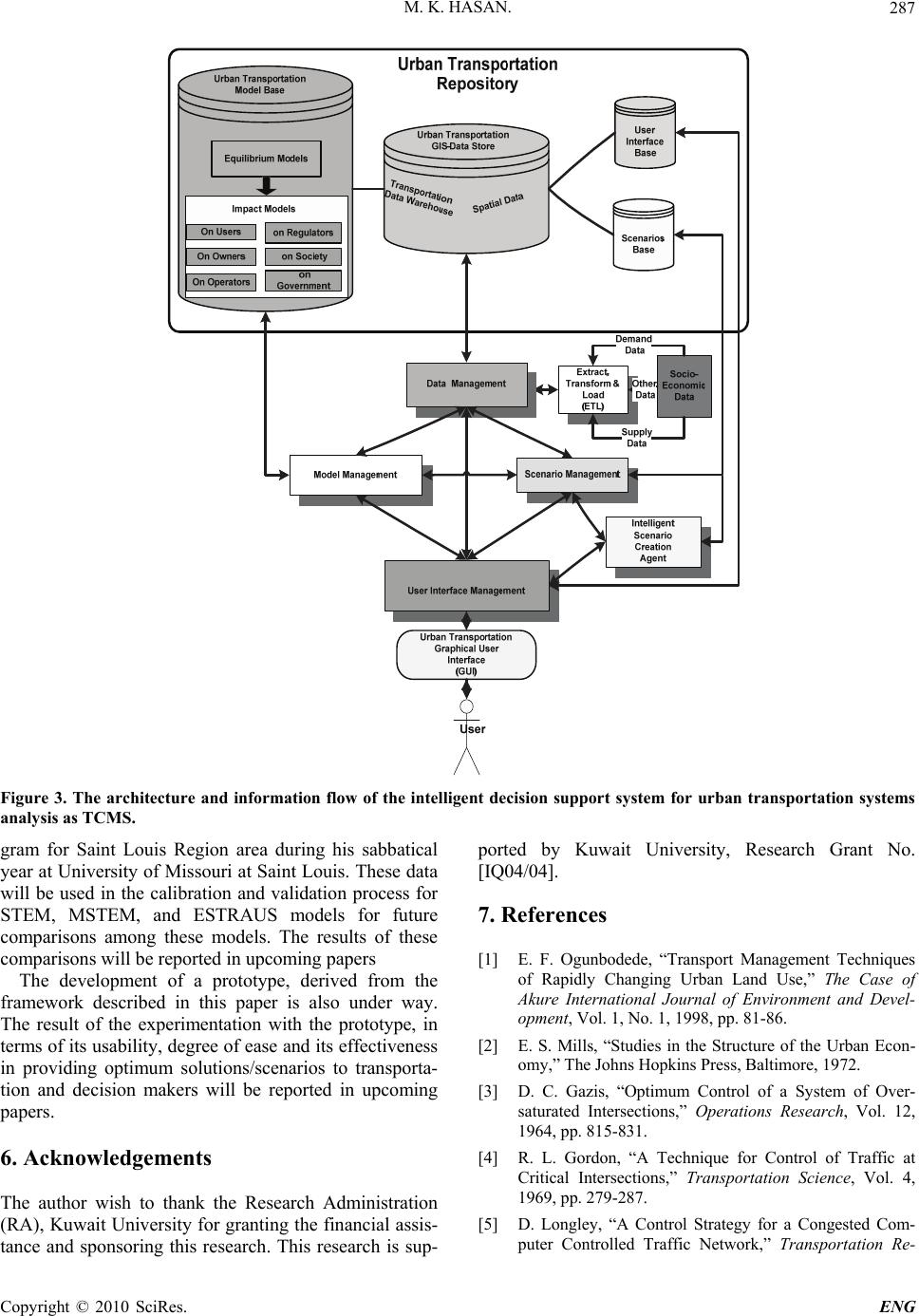 M. K. HASAN. 287 Figure 3. The architecture and information flow of the intelligent decision support system for urban transportation systems nalysis as TCMS. a gram for Saint Louis Region area during his sabbatical year at University of Missouri at Saint Louis. These data will be used in the calibration and validation process for STEM, MSTEM, and ESTRAUS models for future comparisons among these models. The results of these comparisons will be reported in upcoming papers The development of a prototype, derived from the framework described in this paper is also under way. The result of the experimentation with the prototype, in terms of its usability, degree of ease and its effectiveness in providing optimum solutions/scenarios to transporta- tion and decision makers will be reported in upcoming papers. 6. Acknowledgements The author wish to thank the Research Administration (RA), Kuwait University for granting the financial assis- tance and sponsoring this research. This research is sup- ported by Kuwait University, Research Grant No. [IQ04/04]. 7 . References [1] E. F. Ogunbodede, “Transport Management Techniques of Rapidly Changing Urban Land Use,” The Case of Akure International Journal of Environment and Devel- opment, Vol. 1, No. 1, 1998, pp. 81-86. [2] E. S. Mills, “Studies in the Structure of the Urban Econ- omy,” The Johns Hopkins Press, Baltimore, 1972. [3] D. C. Gazis, “Optimum Control of a System of Over- saturated Intersections,” Operations Research, Vol. 12, 1964, pp. 815-831. [4] R. L. Gordon, “A Technique for Control of Traffic at Critical Intersections,” Transportation Science, Vol. 4, 1969, pp. 279-287. [5] D. Longley, “A Control Strategy for a Congested Com- puter Controlled Traffic Network,” Transportation Re- Copyright © 2010 SciRes. ENG  M. K. HASAN. 288 search, Vol. 2, 1968, pp. 391-408. [6] L. J. Pignataro, W. R. McShane, K. W. Crowley, B. Lee and T. W. Casey, “Traffic control in over saturated con- ditions,” NCHRP Report, No. 194, 1978. [7] N. H. Gartner, C. Stamatiadis and P. J. Tarnoff, “Devel- opment of Advanced Traffic Signal Control Strategies for Intelligent Transportation Systems: Multilevel Design,” Transportation Research Record, Vol. 1494, 1995, pp. 98-105. [8] D. J. Quinn, “A review of queue management strategies,” Traffic Engineering and Control, Vol. 33, No. 11, 1992, pp. 600-605. [9] A. K. Rathi, “A Control Strategy for High Traffic Density Sector,” Transportation Research B, Vol. 22, No. 2, 1988, pp. 81-101. [10] A. K. Rathi, “Traffic metering: An Effectiveness Study,” Transportation Quarterly, Vol. 45, No. 3, 1991, pp. 421- 440. [11] T. S. Reddy, E. Madhu and J. V. R. Reddy, “TSM Ac- tions to Improve the Traffic Operations-A Case Study,” ACE, Vol. 2, 2002, pp. 922-932. [12] J. V. R. Reddy, “Application of TSM Actions-A Case Study on Mathura Road in Delhi,” Master’s Thesis, Uni- versity of Baroda, Vadodra, 1998. [13] J. M. Thomson, “Reflections on the Economics of Traffic congestion,” Journal of Transport Economics and Policy, Vol.32, No. 1, 1998, pp. 93-112. [14] Adefolalu, “Traffic Management and Enhanced Urban Environment in Nigeria: A Discussion,” In: E. O. Adeniyi and I. B. Bell-Imam Ed., Op Cit, 1977. [15] S. O. Oyefesobi, “Measures to Improve Traffic Flow and Reduce Road Accidents in Nigeria,” In: S. O. Onako- maiya and K. F. Ekanem Ed., Transportation in Nigerian. National Development Proceedings of a National Con- ference, Ibadan, July 1977, pp. 4-9. [16] J. M. A. Orioke, “Traffic Education and Flow in Ibadan City,” In: S. O. Onakomaiya and N. F. Ekanm Ed., Op. Cited, 1981. [17] M. A. Kennedy and K. Walter, “TSM Measures for Ma- jor Activity Centers,” Transportation Engineering Jour- nal, Vol. 105, No. 5, 1979, pp. 499-511. [18] E. Lindquist, “Assessing Effectiveness Measures in the ISTEA Management Systems,” Southwest Region Uni- versity Transportation Center, Texas Transportation In- stitute, College Station, Texas, 1999. [19] http://www.countyofkings.com/kcag/Plans_Programs/Re gional%20Transportation %20Plan%20Section/Final-TS [20] http://www.madisonareampo.org/Plan%20Elements/Con gstMngt.pdf [21] http://www.marc.org/transportation/cms/policy.pdf [22] http://www.gvmc.org/transportation/CongestionManage [23] S. Ossowski, J. Hernandez, M. Belmonte, A. Fernandez, A. Garcıa-Serrano, J. Pe´rez-de-la-Cruz, J. Serrano and F. Triguero, “Decision Support for Traffic Management Based on Organizational and Communicative Multiagent Abstractions,” Transportation Research Part C, Vol. 13, 2005, pp. 272-298. [24] S. French, “Decision Analysis and Decision Support Systems,” University of Manchester, Manchester, 2000. [25] M. Silver, “Systems that Support Decision Makers,” John Wiley, Berlin, 1991. [26] M. Klein and L. Methlie, “Knowledge-Based Decision Support Systems,” John Wiley, Berlin, 1995. [27] J. Hernandez and J. Serrano, “Environmental Emergency Management Supported by Knowledge Modelling Tech- niques,” AI Communications, Vol. 14, No. 1, 2001, pp. 13-22. [28] J. Hernandez and J. Serrano, “Reflective Knowledge Models to Support an Advanced HCI for Decision Man- agement,” Expert Systems with Applications, Vol. 19, No. 4, 2000, pp. 289-304. [29] I. Vlahavas, N. Bassiliades, I. akellariou, M. Molina, S. Ossowski, I. Futo, Z. Pasztor, J. Szeredi, I. Velbitskiyi, S. Yershov and I. Netesin, “Expernet—An Intelligent multi-agent System for WAN Management,” IEEE Intel- ligent Systems, Vol. 16, No. 7, 2002, p. 62. [30] J. Cuena, S. Ossowski, “Distributed models for decision support,” In: Weiss Ed., MIT Press, Cambridge, 1999, pp. 459-504. [31] S. Ossowski, J. Hernandez, C. Iglesias and A. Fernandez, “Engineering Agent Systems for Decision Support,” In: T. Zambonelli Eds., Engineering Societies in an Agent World III, Springer, Berlin, 2002, pp. 234-274. [32] C. Iglesias, M. Garijo Ayestara´n and J. Gonza´lez, “A Survey of Agent-Oriented Methodologies,” Intelligent Agents V, Springer, Berlin, 1999, pp. 317-330. [33] K. Hoa Dam, M. Winikoff, “Comparing agent-oriented methodologies,” In: Giorgini et al. Eds., Agent-Oriented Information Systems, Springer, Berlin, 2003, pp. 78-93. [34] C. W. Holsapple, “Decision Support Systems. Encyclo- pedia of Information Systems,” Vol. 1, 2003, pp. 551- 565. [35] H. L. Zhang, “Agent-Based Open Connectivity for Deci- sion Support Systems,” Ph.D. Thesis, School of Com- puter Science and Mathematics, Victoria University, 2007. [36] M. K. Hasan and H. M. Dashti, “A Multiclass Simulta- neous Transportation Equilibrium Model,” Networks and Spatial Economics, Vol. 7, No. 3, 2007, pp. 197-211. [37] J. De Cea, J. E. Fernandez, V. Dekock, A. Soto and T. L.Friesz, “ESTRAUS: A Computer Package for Solving Supply-Demand Equilibrium Problem on Multimodal urban Transportation Networks with Multiple User classes,” The Annual Meeting of the Transportation Re- search Board, Washington, DC, 2003. [38] M. Florian, J. H. Wu and S. He, “A Multi-Class Mul- ti-Mode Variable Demand Network Equilibrium Model with Hierarchical Logit Structures,” In: Current Trends, M. Gendreau and P. Marcotte Eds. Dordrecht, 2002, pp. 1131-1119. [39] D. E. Boyce, H. Bar-Gera, “Multiclass Combined Models Copyright © 2010 SciRes. ENG  M. K. HASAN. Copyright © 2010 SciRes. ENG 289 for Urban Travel Forecasting,” Networks and Spatial Economics, Vol. 4, 2004, pp.115-124. [40] J. De Cea, and J. E. Fernandez, “Transit Assignment for Congested Public Transport Systems: An Equilibrium Model,” Transportation Science, Vol. 27, No. 2, 1993, pp. 133-147. [41] K. N. A. Safwat, and T. L. Magnanti, “A Combined Trip Generation, Trip Distribution, Modal Split and Traffic Assignment Model,” Transportation Science, Vol. 22, No. 1, 1988, pp. 14-30. [42] N. Oppenheim, “Urban Travel Demand Modeling: From Individual Choices to General Equilibrium,” John Wiley and Sons, New York, 1995. [43] B. Ran and D. E. Boyce, “Modeling Dynamic Trans- portation Networks,” Springer-Verlag, Berlin, 1996. [44] M. J. Smith, “The Existence, Uniqueness and Stability of Traffic Equilibria,” Transportation Research B, Vol. 13, 1979, pp. 295-304. [45] M. J. Smith, “The Existence and Calculation of Traffic Equilibria,” Transportation Research B, Vol. 17, 1983, pp. 291-303. [46] S. C. Dafermos, “An Iterative Scheme for Variational Inequalities,” Mathematical Programming, Vol. 26, 1983, pp. 40-47. [47] S. C. Dafermos, “Relaxation Algorithm for the General Asymmetric Traffic Equilibrium Problem,” Transporta- tion Science, Vol. 16, No. 2, 1982, pp. 231-240. [48] M. Florian and H. Spiess, “The Convergence of Diago- nalization Algorithms for Asymmetric Network Equilib- rium Problems,” Transportation Research B, Vol. 16, 1982, pp. 447-483. [49] H. S. Mahmassani and K. C. Mouskos, “Some Numerical Results on the Diagonalization Network Assignment Al- gorithm with Asymmetric Interactions between Cars and Trucks,” Transportation Research B, Vol. 22, 1988, pp. 275-290. [50] Y. Sheffi, “Urban Transportation Networks: Equilibrium Analysis with Mathematical Programming Methods,” Prentice-Hall, Englewoods Cliffs, 1985. [51] K. N. A. Safwat and B. Brademeyer, “Proof of Global Convergence of an Efficient Algorithm for Predicting Trip Generation, Trip Distribution, Modal Split and Traf- fic Assignment Simultaneously on Large-Scale Net- works,” International Journal of Computer and Mathe- matics with Applications, Vol. 16, No. 4, 1988, pp. 269- 277. [52] S. Rosenbloom, “Peak-Period Traffic Congestion: A State-Of-The-Art Analysis and Evaluation Of Effective Solutions,” Transportation, Vol. 7, 1978, pp. 167-191. [53] T. Efraim, et al., “Decision Support and Business Intelli- gence Systems,” 8th Edition, Pearson Prentice Hall, New Jersey, 2007. [54] W. Inmon, “Building the Data Warehouse, 4th Edition, Wiley, New York, 2005. [55] D. Boyce, “Forecasting Travel on Congested Urban Transportation Networks: Review and Prospects for Network Equilibrium Models,” Networks and Spatial Economics, Vol. 7, 2007, pp. 99-128.
|