International Journal of Geosciences
Vol. 4 No. 4 (2013) , Article ID: 33487 , 13 pages DOI:10.4236/ijg.2013.44075
Geological and Geoengineering Properties of the 1997 Yangjia Shan Landslide, Enshi, China
1Institute of Geophysics & Geomatics, China University of Geosciences, Wuhan, China
2Faculty of Engineering, China University of Geosciences, Wuhan, China
3Three Gorges Research Center for Geohazard, Ministry of Education, China University of Geosciences, Wuhan, China
Email: *tanghm@cug.edu.cn
Copyright © 2013 M. A. M. Ez Eldin et al. This is an open access article distributed under the Creative Commons Attribution License, which permits unrestricted use, distribution, and reproduction in any medium, provided the original work is properly cited.
Received March 22, 2013; revised April 25, 2013; accepted May 23, 2013
Keywords: Rainfall; Lithology; Weathering; Yangjia Shan Landslide; Laboratory Test
ABSTRACT
Yangjia Shan instability has been evidenced by the occurrence of the July 16, 1997 landslide. The instability factor which leads to activating the landslide is the intense rainfall; lithology of Luoreiping Formation and the highly weathered slopes’ rocks have played a great role in starting and aggravation. Weathering at the landslide site consists largely of attack on the cement and removal of support of the sandy mudstone and sandstone and decompose of shale. The weathering degree of the rocks decreases vertically with increasing depth from high, medium to slightly weathered corresponding to grade IV, III and II, respectively. The slip surface consists of moderate to highly weathered intercalated layers of sandy mudstone (mudstone) and shale, while, the layer below the slip surface is characterized by dark gray, moderately weathered and thick layered mudstone. The moderate to highly weathered subsurface lithology is probably attributed to the accumulation of the infiltrated rainfall water through fractures and porosity, raising the ground water level and wetting of the sandy mudstone and shale rocks of Luoreping Formation. The wetting contributed more or less to the disintegration of the sandy mudstone and shale, lowered the shear strength and created cracks on the upper part of the slope leading thus to increase the landslide susceptibility. Therefore, the frequency and magnitude of landslide at the study area and its vicinity are expected to increase through the activation of old landslides and triggering of new ones under circumstances similar to those of the past.
1. Introduction
Landslides, rock falls and Debris flows are severe abrupt mass movement hazards, whose recorded occurrence in China has increased markedly in the past two decades.
Within the Chinese population, landslides annually cause a great amount of casualties and great losses in the Chinese economy. Severe mass movement disasters in China have been attributed to both natural conditions and human activities [1,2]. Most of these abrupt mass movement disasters occur in the mountainous areas, high plateaus and hilly areas characterize by having fine to very fine-grained silici-clastic sedimentary rocks (clay-bearing rocks) such as sandy mudstone, shale and siltstone. The influencing degree of landslides on natural environment and human society is ordered after earthquake and volcano [3]. According to [4], the occurrence of most landslides in China was largely predisposed by tectonics, geological structures, lithology and topography and often triggered by rainfall and earthquakes. [5] investigated and statistically analyzed the major factors that are found to have affected the slope stability and contribute to the occurrences of landslides in the fore reservoir region of the Three Gorges Project on the Yangtze River as follows: rocks types and association; structure, texture combination; valley slope geometry; hydrological conditions and dynamical factors, the former two being the most important. The importance of lithology as a preparatory factor is shown by the fact that most landslides occur in clay rich and jointed (Silurian Units) or loose units (Quarternary Units) [6].
Rainfall in Enshi is quite intense and contributes significantly to the weathering of rocks. Thus the rocks here are subject to a high degree chemical weathering. The intensity and thickness of the weathered zone which are fundamental factors controlling slope instability are changeable with time as the weathering proceeds [7]. According to [8], landslides in tropical and sub-tropical regions are generally associated with weathered rock profiles which often possess chemical and mineralogical heterogeneities at material and mineral scales. Therefore, weathering of rocks is one of the primary causes of slope failure and shallow landsliding in hilly areas by destruction the chemical structure, disintegration, dissolving of the rock and carrying the minerals by the action of water. In general, a slope becomes unstable gradually as the weathering of rocks proceeds inward from its surface and it typically fails during heavy rainfall. This type of failure is widely known from many places, especially from monsoon regions such as China [9]. The slope failures that frequently occur in the study area are of this type. The hazardous area tends to occur on outcrops of less resistant material. Therefore, the identification of past landslides and understanding of their mechanisms of movement is important for predicting future landslides of a similar type and mechanism [10]. [11] studied the effect of loose structure on slope stability; they concluded that, the material composition of Yangjia Shan landslide and hydrogeological condition are important factors in slope stability analysis. The residents depend on the agricultural activity on the steep slopes of the mountain therefore; areas close to the settlements and forested slopes were cleared to make way for vegetables and fruit trees and upland for grain fields. According to [12], the slope instability links the geological and socio-economic environments due to the settlement to higher ground, intensive cultivation on the less resistant slopes of the mountain will reactivate and increase the frequency and magnitude of old landslides and will trigger new ones.
Yangjia landslide is located at the Yangjia Shan village, Tunbao Town, Enshi City (Figure 1), southwestern of Hubei Province. It’s bounded by latitude 29˚07'10" and 31˚24'13"E and longitude 108˚23'12" and 110˚38'08"N. It is located in wrinkled terrain in eastern extended part of Yunnan-Guizhou plateau, where the landslide happens frequently and causes threats to people’s life and property and hauled the development of the local economic construction and brings bad effect on the social development. It hosts the richest selenium resource in the world, where selenium is present mainly in the carbonaceous siliceous rocks and carbonaceous shale [13].
Yangjia Shan instability has been evidenced by the occurrence of two landslides; on August 5, 1980 and July 16, 1997. The latter was triggered by the intense rainfall; lithology and weathering has played a great role in starting and aggravation. The July 16, 1997 landslide has partial sliding and it is still creeping, it has some distortion of bad stability. The affected areas are estimated to be about 63.333 hectares of agricultural lands, 160 private
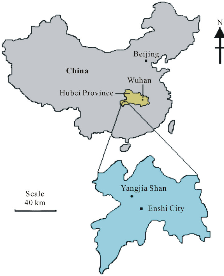
Figure 1. Location map of the study area.
residences and create 200 persons homeless. At present, the landslide threatens more than 1000 residents and properties cost over eighty US $ million dollars.
This article focuses on the geological, weathering and geoengineering properties of rocks (sandy mudstone, shale, sandstone, siltstone and limestone) and soil materials which might play a greater role on the occurrence of the July 16, 1997 Yangjia Shan landslide. Our study tries to understand the initiation of the 1997 landslide and elucidate conditions that may trigger new ones under circumstances similar to those of the past. The study achieved by conducting regional and detailed fieldwork and laboratory analysis of rock and soil samples collected from the landslide. Five exploratory boreholes were drilled to study the hydrogeological characteristics and explore the body of the landslide. In the present study, the rock units were identified and studied with reference to their degree of weathering.
2. Topography and Drainage System
The land of Enshi and its vicinity is complicated landform, more than 90% is mountainous areas; northwest and southeast are higher in elevation (average 1550 m), and the northeast and southwest are lower in elevation (average elevation 800 - 1300 m). The central area is a river basin in the mountains, with an average elevation of about 500 m.
The Qingjiang River bounded Yangjia Shan landslide from the south, it incised into steeply wall rocky gorges and forms one of the upper reaches of larger subwater sheds that drain into the Yangtze River. Flows within the river are primarily in response to a combination of precipitation, karsts springs and groundwater seepage in the wet season, and springs and groundwater seepage in the dry seasons. Streams originated from the Yangjia Shan discharge their water into the Qingjiang River (Figure 2).
3. Climate and Vegetation Cover
The study area is situated in a subtropical monsoon climate of middle latitude, easily affected by the season changing. The annual average temperature ranges from 17.4˚C to 7.8˚C and the annual precipitation is 1400 - 1600 mm, the maximum monthly precipitation in July, 1997 was 569.22 mm (Figure 3) and the relative humidity is 85%. The climate characterizes by cold days in winter, hot days in summer, heavy fog and humid climate through all of the year. The rain feature in the study area is characterized by longer lasting time in autumn than in spring. The rainfall and temperature change dramatically through the year, this is due to the various changes that occur to the seasonal incoming winds, retreating time and intensity, as a result climate disasters frequently occurs.
The vegetation covers approximately 28.5% to 70% of the land surface. This percentage is higher than the natural average for Hubei Province (12.7% - 23.5%).
4. Method of Investigations
Several visits were made to Yangjia Shan, and its vicinity. During the visit, regional and detailed geological fieldwork has been carried out. Google Earth Imagery and topographic sheet and geological maps (1:500,000)
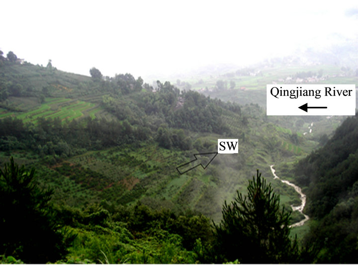
Figure 2. The small stream represents the western boundary of the Yangjia Shan landslide; it discharges into the Qingjiang River. SW (southwest) is the direction of Yangjia Shan landslide.
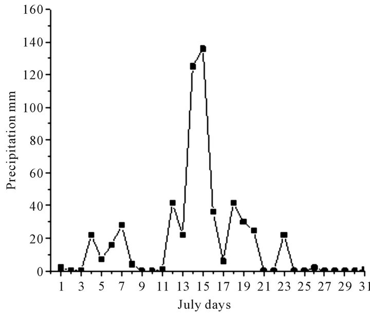
Figure 3. The maximum daily precipitation of Yangjia Shan on July, 1997.
were used to provide information regarding the main relief forms and related morphological processes operating on the slope. Five exploratory boreholes (ZK6, ZK7, ZK8-1, ZK8 and ZK9) were drilled to study the hydrogeological characteristics and explore the body of the landslide from the top till below the slip surface. The different rock units were identified and studied with reference to their bedding planes, fractures, sedimentary structures, degree of weathering and tectonics. Dip and strikes of beds and fracture orientation and dipping were measured. Soil and rock samples representing all of the landslide areas were collected for thin sections and laboratory tests. The physical properties test of soil (particle-size distribution, coefficients of uniformity, coefficient of curvature, water content, specific gravity, Atterberg limits, and plasticity index) and rocks (specific gravity, bulk density, porosity and water absorption capacity) and identification of the clay mineral assemblage by using X-Ray Diffraction (XRD) analysis were carried out.
5. Geology and Setting
Rocks of the Ordovician-Silurian Systems outcrop in the study area and its vicinity, their lithologies (Figure 4) mainly are carbonate, argillaceous and clastic rocks they are arranged chronologically in ascending order.
5.1. The Quaternary Deposits (Q)
It’s composed of recent, loose and soft deposits, formed by winds, running water and artificial earth filled. The proluvium (Q4pl), diluvium (Qdl) and loose new deposits are widely distributed on the slope body and erosion surfaces (Q4del). Fluvial clay and gravel are detected on stream terraces, as well as slope deposits and mixed layers of those lithologies most susceptible to landslide.
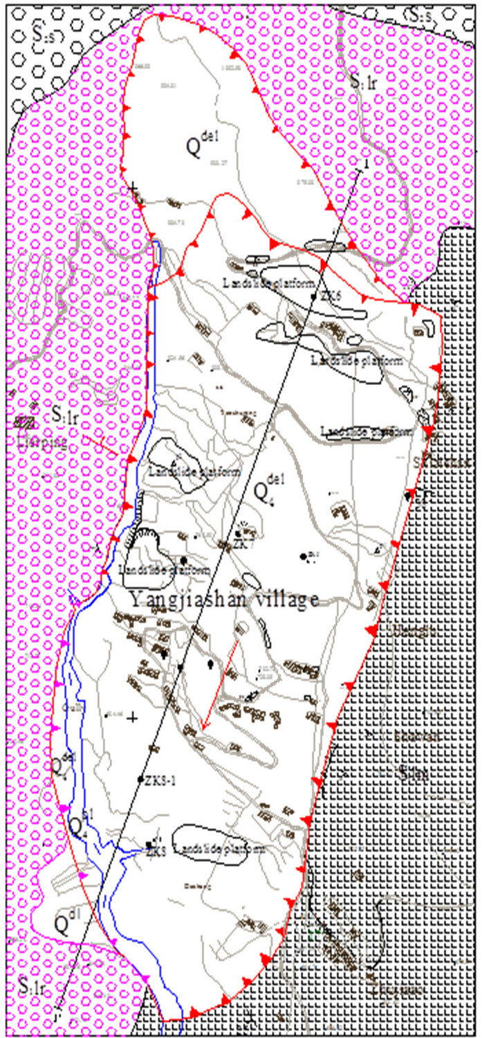
Figure 4. Engineering geological map of Yangjia Shan landslide.
5.2. Shamao Formation (S2) of the Late Silurian System
Lithologically, four members of Shamao Formation can be recognized. The first and third member consists of mudstone and siltstone, while the second and the fourth member are characterized by sandstone and siltstone, [14]. The first member is characterized by yellowishgreen silty mudstone intercalated with siltstone. The second member comprises of a set of yellowish-green and grayish-green thin-bedded siltstone, and fine sandstone, intercalated with sandy shale and shale. The base is marked by the incoming of very red mudstone bands.
Its top is readily drawn at the appearance of a thin band of brown ferruginous calcareous sandstone. The third member overlying Member two, it composes of yellowish or grayish-green shale, and sandy shale with a few bands of argillaceous siltstone and Member four lies at the top member of the Shamao Formation is composed of grayish-green and very red barren medium bedded fine-grained quartz sandstone and siltstone intercalated with sandy shale.
5.3. Luoreiping Formation (S1lr) of the Early to Middle Silurian System
The Luoreping Formation is composed of yellow to green, thinly bedded sandy mudstone, thin to medium thickly bedded siltstone; fine to medium-grained sandstone contains iron oxides and carbonaceous material, sandy shale and dark gray shale with spider-shape structure. Their average dipping is 15˚SW. The whole is alternating with each other. The rocks of this formation are very hard except the sandy mudstone (weak, fractured highly moisturized and the highly weathered is mixed with the Quaternary deposits) and shale, they are ductile and easily broken into irregular shapes, some varieties are of medium hardness. The lithology of this formation is responsible for the two events of the landslide (Figure 4).
5.4. Longmaxi Formation (S1lm) of the Early Silurian System
The Longmaxi Formation (Figure 4) is composed of black and yellowish-green graptolitic shale. Its top which is the lower part of the Luoreiping Formation is drawn at the appearance of abundant shelly fossil-bearing silt mudstone with nodules. The Longmaxi Formation is further divided into a Lower Black Shale Member, and an Upper Yellowish-green Shale Member [15]. The Black Shale Member is a set of black shale, the upper part of which gradually weathers into gray black shale. There is also grayish-black thin-bedded siliceous rock with shale. On the other hand, the Yellowish-green Shale Member consists of yellowish-green shale, and sandy shale with a few sandstone bands, and few shelly fossils. The uppermost zone can, however, range up to the Luoreiping Formation. The average dip of the formation is 22˚SW. The rocks of this formation apparently look strong, tough and slightly to moderately weathered than Luoreiping Formation.
5.5. The Limestone and Dolomite (O2) of the Late Ordovician System
The limestone is gray to purple gray, medium thickness, greasy and composed of quartz, calcite and plagioclase. It is very hard, compact and contains randomly distributed microfractures. In some localities the fractures (two sets) are filled by fine-grained to well grown calcite crystals. The voids in this rock are of different sizes, ranges from very small to medium size. The silicified limestone is characterized by having high silica content and low porosity while, the weathered varieties were characterized by elephant skin weathering.
The structures here are of two major systems with complex conjunction relationship. The gentle folds and faults trending northeast belonging to the New Cathaysian system are dominant in the southwestern part and extend through the study area. The gentle anticlines and tight synclines as well as the related faults are extending in the S-N direction in the central and western parts, belonging to the meridional structural system and their traces of activity are distinct. Fracture zones are associated with rock weakness and can locally increase permeability within sequences, resulting in an enhanced groundwater leakage and the development of paths for preferential flow. During the Cenozoic, uplift resulted in rejuvenation and stability and from the Cenozoic to present day older landforms have been greatly uplifted while the Yangtze River, Qingjiang and their tributaries incised deeply into the plateau mountains, and steep gorges developed. Most of the landslides in China are very close to the major fault zones [16], the tectonic zones have offered favorable settings for the landslides and have controlled their regional distribution patterns [4]. With reference to the field investigation, the tectonic at the study area imposed controls on the landslide in three ways: created favorable terrains, provided sufficient rockslide prone materials such as highly fractured or weak rocks and formed very steep beds which reduced the stability of the rock slope.
6. Fractures
[17] defined fractures as “parting planes along which there has been little or no displacement”. Generally, fractures may represent possible sites for surface of sliding, potential leakage channels and untrusted sites in the stability of slopes.
The rocks at the area of study are characterized by having different sets of fractures more or less parallel and regularly spaced; their spacing varies from narrow to wide. The horizontal fractures are coinciding with the bedding planes of sandy mudstone, shale, sandstone and siltstone. The successive distances between fractures are varied; they range from 20 cm to 130 cm and their width range from 1 mm to 7 cm. The length of some fractures exceeds 100 cm, run in two sets in rare cases cross each other. Most of the studied fractures can be described as tight, partly open or have very clear visible cavities. The cavities are either empty or filled by clays and/or rock fragments. Their surfaces are wavy, smooth, rough or weathered. Their set frequency increases with proximity to the tectonic plane. In case of tight fractures, the rupture is quite apparent to the naked eye, though the walls of the fractures are brought together to such an extent that it becomes impossible to see the cavity along the rupture [18]. Blind and refilled fractures by iron oxides, calcite and clays are not uncommon. The measurements of the strikes of the fractures were plotted using rose diagram, with the aim of establishing the predominant orientation of the fractures (Figure 5). The genesis of the fractures is probably tectonic in origin.
7. Weathering
Weathering is the process, which acts on the earth’s surface to decompose and break down rocks, it is one of the primary causes of slope failure and shallow landsliding in hilly areas by destruction the chemical structure, disintegration, dissolving of the rock and carrying the minerals by the action of water [9]. Weathering and subse-
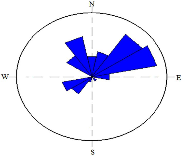
Figure 5. Rose diagram of strike trends of fractures showing their relative prevalence.
quent alteration processes affect rocks by changing their physical, chemical, mineralogical, petrographical and mechanical properties [19], so that weathering and alteration features develop on the surface and in deep zones of rocks. Chemical weathering is very active in the study area and rock material change occurs by chemical decomposition. The chemical weathering of soft sedimentary rocks consists of sequential interactions between percolating groundwater and rock [20,21], and the oxidation and rock deterioration are, sometimes rapid enough to cause geological engineering problems [22].
The development of weathering and alteration in the rocks in the study area occurs through changes in physical properties and hence deterioration of the rocks. The style and rate of weathering are controlled by porosity, water absorption and discontinuities of the rocks, which governs the ease with which water can enter and the weathering products be removed. Porosity is in turn controlled by grain packing and the amount of space between grains as well as rock structures. The rocks at the surface are in a continuous state of decaying while those below decompose by solution of elements in water, which enter through fractures, bedding and cross-bedding. The average thickness of the highly weathered zone as revealed from the boreholes data varies from one place to another at the location of the landslide; it is about 17 m at the top (NE) and 49 m at the toe (SW) of the landslide. Generally, the weathering degree of the rocks decreases vertically with increasing depth (from highly; medium to slightly weathered corresponding to grade IV, III and II, respectively (Table 1 [23-25] and Figure 6)).
Weathering at the landslide site consists largely of attack on the cement and removal of support of the sandy mudstone and sandstone and decompose of shale (Figure 7), siltstone and limestone. The clay matrix and sandstones weather by breaking down and elevations of clay. The petrographic study indicated that there is mineral alteration occurred to the plagioclase and K-feldspar. The alterations attribute to the action of the penetrating water
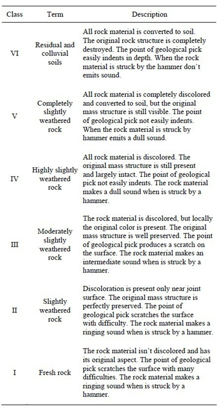
Table 1. Descriptions assumed as reference for the weathering classes (from [23-25] modified).
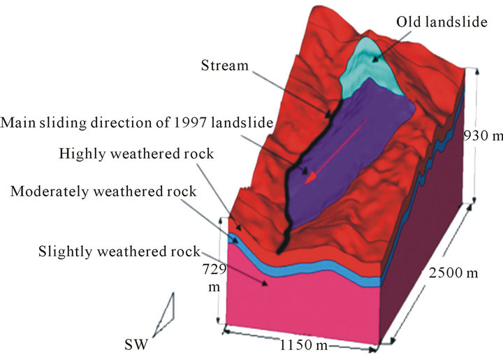
Figure 6. Block diagram showing the 1980 old landslide and the July 16, 1997 Yangjia Shan landslides.
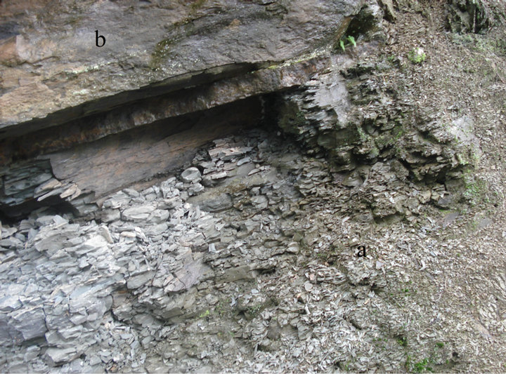
Figure 7. (a) Highly weathered (below) and (b) moderately weath ered shale, Yangjia Shan landslide.
through porosity and discontinuities of the rocks.
Generally, shales, mudstones, and siltstones show rapid disintegration when exposed to atmospheric processes. The disintegration characteristics of these rocks depend on their physical and mineralogical properties such as the amount and type of clay minerals, dry density, absorption, porosity, presence of laminations, and geological age [26].
Yangjia Shan landslide slope’s becomes unstable gradually as the weathering of rocks proceeds inward to a considerable depth from the surface. Fieldwork indicates that, the channel of the stream situated west of the landslide (Figure 6) has a greater influence upon the slope instability due to the action of erosion, deep weathering and facilitate water infiltration to the subsurface rocks.
8. Sampling and Laboratory Tests
8.1. Soil Laboratory Tests
Landslide material properties were determined on samples collected from the different locations of the landslide area by laboratory tests. Disturbed samples were collected for grain-size analyses, Atterberg limits, water content and specific gravity tests according to ASTM standards [27]. In addition, the X-ray diffraction analysis was carried out in order to identify and semi-quantitatively deduce the percentages of the different clay minerals present in the soil of the landslide at China University of Geosciences Central Laboratory using a Philips diffractometer. The XRD analysis revealed that, the soil samples composed of four clay minerals (Figure 8), their dominant availability is: Illite (occurs in most of the examined samples throughout the study intervals), Kaolinite, Chlorite (is authigenic formed by the alteration of biotite as detected in some thin sections) and Pyrophyllite, respectively.
The Grain-size distribution test was carried out for the
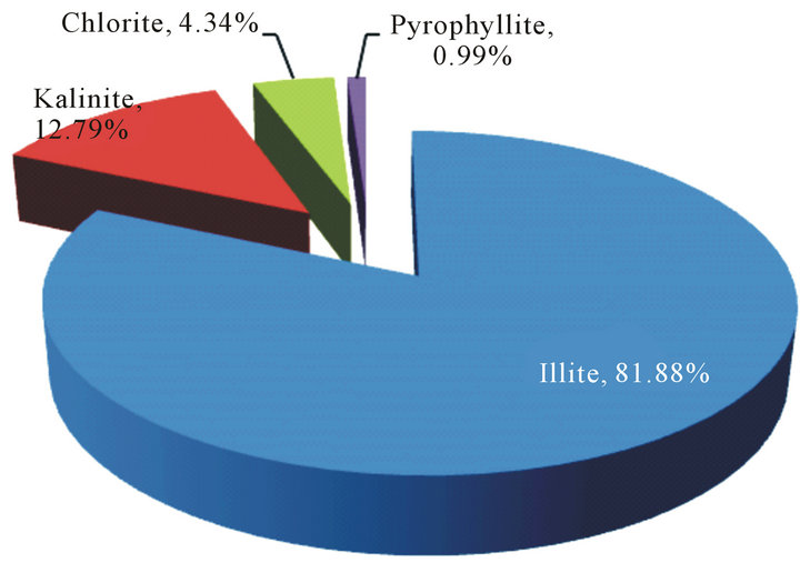
Figure 8. Clay minerals % of Yangjia Shan landslide.
coarse and fine-grained soils to determine the ranges of the particle size and percentage of the total weight represented by the grain in the various size ranges. It is seen that for the full sieved soil the clay and silt fractions dominate this material; this is due to the weathering of the different source rocks (sandy mudstone, sandstone, siltstone, and shale). The coefficient of uniformity (Cu) of the soil is characterized by nonuniform gradation, this is due to the inhomogeneity of the slope components while, the coefficient of curvature (Cc) is interpreted as poorly graded and characterized by irregular curve due to the different ranges of the particle size.
The water content of the soil is described as normal (32% to 45.5%), while the results of the specific gravity (2.701 g/cm3) lie above the range given to the soil [28]; this is probably due to the weathering of iron content source rocks such as the ferruginated sandstone.
The plastic properties of the fine soil material are expressed in terms of liquid limit (LL), plastic limit (PL) and plasticity index (PI), as first proposed by Atterberg. These limits control the consistency of the soils as wetting conditions change. The liquid limit (LL) ranges from 5.32% to 49.86% for the soil samples, the plastic limit (PL) from 33.82% to 23.32% and the plasticity index from 4.11% to 18.87%. Therefore, the liquid and plastic limits of the soil samples can be classified as low to medium plasticity and in terms of plasticity; it can be classified according to [29] as: slightly to moderate plastic inorganic clay (CL) (Figure 9). The results of the XRD analysis and Atterberg limits showed that, the slightly to moderately plastic inorganic clay indicates the existence of inexpansive clays in the soil of the Yanjia Shan landslide.
8.2. Rocks Laboratory Tests
The specific gravity, bulk densities (natural, dry and saturated), porosity and water absorption capacity of the sandy mudstone, shale, sandstone, siltstone and lime-
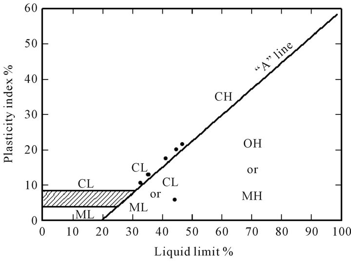
CH: High plasticity clay ML: Low plasticity silt OH: High plasticity organic soil (Rare)
CL: Low plasticity clay MH: High plasticity silt
Figure 9. Plasticity chart of the soil collected from Yangjia Shan landslide.
stone, were determined. The mean values of the specific gravity and bulk densities fall within the normal range given to the rocks (Figure 10).
Porosity is one of the important physical properties that govern physical attributes of rocks such as moisture content and strength. Weathering processes cause progressive changes in rock porosity due to change in pore size distribution, pore geometry, pore connectivity, pore infilling and new pore formation. In sedimentary rocks, porosity depends on grain size, shape of the grains, degree of sorting, and degree of cementation. Highly fractured solid rocks, however, could have high porosity. The nature of the fluid or fluids that flow through the pores between the grains often determines changes to the pores and porosity as does the composition of the grains and their chemical stability. The sandy mudstone and shale have recorded the highest porosity compared with sandstone, limestone and siltstone (Figure 11). The low porosity of the sandstone can be attributed to the nature and characteristics of the sand and cement that accumulates after deposition. The limestone and siltstones are silicified, compact and tough due to their location near to Enshi fault zone.
The water absorption capacity of the sandy mudstone, shale, sandstone, siltstone and limestone is carried out to determine whether there is a relation between the natural porosity and the water absorption for the mentioned rocks. As seen in Figure 11, the sandy mudstone and shale showed high susceptibility to absorb water than siltstone, sandstone and limestone. There is a significant correlation between the porosity and water absorption for the Yangjia Shan rocks, the sandy mudstone and shale rocks have relatively higher porosity therefore, they have
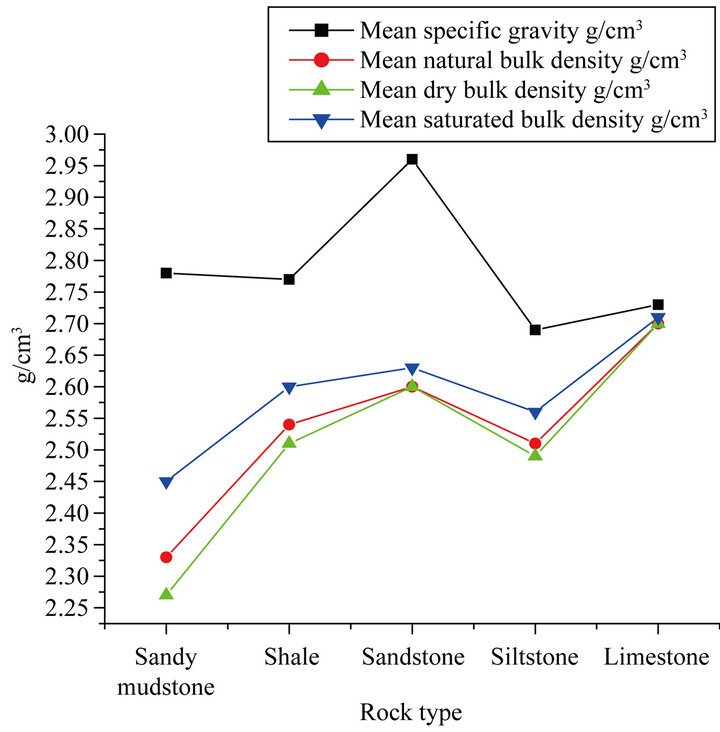
Figure 10. Mean specific gravity and natural dry and saturated bulk densities of Yangjia Shan rocks.
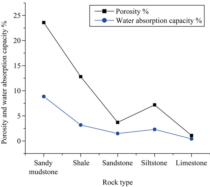
Figure 11. The mean porosity, specific gravity and water absorption capacity of Yangjia Shan rocks.
the tendency to absorb significant amounts of water compared with siltstone, sandstone and limestone.
9. Geological and Geomorphological Characteristics of Yangjia Shan Landslide
Yangjia Shan is characterized by steep to gentle slopes, thus it produces steep to gentle nature landslide. The dimension of the slided area is about 99 × 104 m2, with volume approximately to 32 million cubic meters. The plane of the landslide assumes long linear-shape with the main trend of SW 212˚/14˚ (Figure 7). The maximum height of the landslide is 980 m (above sea level), the minimum after reckoned is 610 m, and average gradient is 148 m/km and thickness of about 50 m. The weathering and erosion are strong and the drainage system is dendritic.
To explore the body of the landslide from the top till below the slip surface, five exploratory boreholes (ZK6, ZK7, ZK8-1, ZK8 and ZK9, the latter borehole is situated east of ZK8) were drilled along the landslide from NE to SW (Figure 12). The log description of the boreholes gave the details of the slip surface, the geological structures and the hydrogeological characteristics of the landslide. The core logs from the whole boreholes contained slickensided and striated surfaces, deformed structure, fine-grained particles, which is generally range from 10% - 30%, rock fragments and ferruginization at 23.7 m, 17 m, 39 m, 49 m and 12.8 m depth, respectively. The deformed layers were considered as the slip surfaces. The slickensided surfaces were generally undulating but occasionally planar. The thicknesses of the slip zones normally vary from 0.4 m to 1 m. Notably, although materials of the slip zones could be visually identified as finegrained soils, they contain significant amount of gravelsized rock fragments. The slip surface consists of moderate to highly weathered intercalated layers of sandy mudstone (mudstone) and shale. The layer below the slip surface is characterized by dark gray, moderately weathered and thick layered mudstone. The 1997 landslide has initiated its activation from the same slip surface of the early 1980 landslide.
The landslide deposit consists of proluvium (Q4pl), diluvium (Qdl), loose new deposits widely distributed on the slope body and erosion surfaces (Q4del) and a mixture of boulders, cataclastic material, siltstone, sandstone and shale belongs to the Silurian Series (Figure 10). The blocks diameter ranges from 3 - 15 cm. The beds of the slope are composed of intercalation of sandy mudstone, sandstone and shale of Luoreping Formation, dipping is 212˚/14˚ SW. The zone of accumulation extends longitudinally to 1500 m starting from the top to the toe of the landslide deposits near to the main road. It is almost has the same width and tapered heads at the two ends.
The surface of the deposits is characterized by an elevated platform in the front and high walls at the peripheries, the most distinct feature in the mid of the landslide is the hummocky and gallery topography, it’s composed of loose yellow to brown sediments, plastic feeling, with a few gravels and plenty of plant roots, it utilizes as suitable agricultural land. The thickness of this layer ranges from 1 m to 8 m (middle) and from 0.2 m to 0.5 m (top and the toe). There are exposures of moderate to highly weathered sandstone, shale and siltstone, and the lower portion includes some outcrops exhibiting moderate to high degree of weathering.
The rainfall supply considerable amount of water to the study area, the majority penetrates deep through the fractures and small amount drain by some small streams.
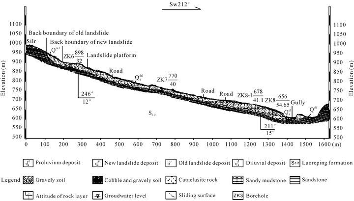
Figure 12. NE-SW geological cross-section along Yangjia Shan landslide.
Water has been observed in the drilled boreholes (ZK6, ZK7, ZK8-1, ZK8 and ZK9) at several depths 24.9 m, 18.0 m, 32.0 m, 47.12 m and 11.6 m, respectively (Figure 3). Several ponds were formed in the low lying parts of the deposits. They are of two types; artificially formed by the local farmers and naturally formed by the intense rainfall. Very quick stream runs from the northeast to the southwest, it represents the western boundary of the landslide within Luoreping Formation; it drains the mountain’s water during rainfall into the Qingjiang River. The stream forms a permanent channel with plenty of water; it erodes and washes away the sediments and highly weathered rocks down slope. It is narrower at the top and wider at the confluence with the Qingjiang River; the width and depth of the stream is approximately 4 m and 2 m, respectively. [30] mentioned that, the in situ rainfall infiltration at a hillside it will flow laterally; a portion of water will infiltrate further down to join the regional groundwater in the form of matrix flow. Therefore, the infiltrated rainfall water through fractures and the porosity of the lithology, accumulate at the subsurface and then lead to increase the groundwater water level, wetting and absorption of water and degree of weathering of the sandy mudstone and shale rocks of Luoreping Formation. Moreover, the infiltrated rainfall probably, lead to increase the rocks weathering, porewater pressure and lowered the shear strength, thus leading to increase of the driving force of the slope and landslide susceptibility.
There is a distinct but irregular zone of fallen trees characterizes the eastern margin of the landslide. The imbrication of the trees is generally consistent with the landslide’s flow direction.
The instability factor which leads to activating the landslide is the intense rainfall and the highly weathered slopes’ rocks. Based on the observation made by the local inhabitants who, reported open cracks on the upper part of the slope before the main movement phase. Then, the landslide took place by sliding the anterior body material followed by planar landslide. The eastern crack is interpreted as the sharp geological boundary of contrasting lithology between Longmaxi and Luoreping Formations.
10. Discussion
The XRD analysis of the soil revealed that, the samples compose of four clay minerals, dominant Illite and less Kaolinite, Chlorite and Pyrophyllite. The XRD and the plasticity index results revealed that, the low to medium plastic inorganic clay indicates the existence of inexpansive clays in the soil of the landslide. For the full sieved soil, all grades are present; this is due to the weathering of the clay-bearing and limestone rocks. Generally, the soil is characterized by nonuniform gradation and poorly graded soil. The water content of the soil interpreted as normal, while, the specific gravity lies above the range given to the soil, this is due to the weathering of the iron content source rocks like ferruginated and silicified sandstone. The liquid and plastic limits can be classified as low to medium plasticity while, the results of the plasticity index of the soil can be classified in terms of plasticity as slightly to moderate plastic inorganic clay.
Lithology (rock type) has influence on the geomorphology of the study area. The nature and rate of geomorphological processes depend, to some extent, on the lithology and weathering characteristics of the exposed and subsurface materials of the landslide process, therefore, it has a direct correlation to lithology [31]. It is also noted that, the tectonics exert a fundamental control on the lithology and movement of groundwater, by creating a favorable environment for triggering the landslide. Fractures tend to weaken the rock mass, increase the process of weathering, decrease the strength of the rocks and created good channels for vertical and horizontal water movement within the lithology of the slope. Enshi fault has reduced the porosity of the sandstone, siltstone and limestone by silicification, brecciation, slickenside and ferruginization and produced negative effects on the lithology by creating tension fractures in localities near to the fault zone.
Rainfall in the study area is quite intense and contributes significantly to the weathering of rocks. Thus the rocks here are subject to a high degree of both chemical and mechanical weathering. The attack on the cement and removal of support has weakened the sandstone and siltstone. The clay matrix, sandstone and siltstone weathers by breakdown and eluviations of clay. Yangjia Shan landslide slope becomes unstable gradually as the weathering of rocks proceeds inward to a considerable depth from the surface and it typically fails during heavy rainfall. Frequent failures along gentle slopes composed of soft, degradable sandy mudstone and shale rocks are believed to be attributable to the weathering of the rocks, because individual failures are very shallow and they tend to repeat over time. [32] noted that the steepness of a slope in relation to the strength of slope forming material was very complex that the steep slope incompetent rocks was more stable (like very steep limestone) than the gentle slope in weaker formation (weak sedimentary rocks). The weathering and softening of these rocks are attributable to changes not only in the physical and mechanical characteristics, but also in the chemical properties of the rocks. Mechanical changes in these rocks include that the surface tends to loosen easily and disintergrate at an early stage. The borehole data revealed that, the stability of the sandy mudstone (mudstone) and shale rocks of Yangjia Shan slope decreases gradually as weathering of rocks proceeds inward to a significant depth because the processes of weathering and erosion are generally active at shallow depth below the surface [33].
The physical tests performed on representative samples from the lithology indicate that, the specific gravity and bulk density of the sandy mudstone, shale, sandstone, siltstone and limestone fall within the normal range, while the relatively high porosity of sandy mudstone and shale is due to their composition and medium to high degree of weathering but, higher porosity and elevated water absorption were observed in highly weathered sandy mudstone and shale. However, the low porosity of the sandstone, siltstone and limestone is attributed to their compaction, cementing material, silicification and ferruginization. The most common cementing materials are silica, carbonate, clays, iron oxides and manganese oxide.
The sandy mudstone and shale of Luoreiping Formation showed high susceptibility to absorb water than siltstone, sandstone and limestone of the same formation. These can be attributed relatively to their high porosity and medium to high degree of weathering. Both porosity and water absorption of sandy mudstone and shale increase and dry bulk density decreases with increasing weathering grade. It is noticed that, shale disintegrates rapidly when absorb water, the disintegration starts from its bedding planes, fissile structure and microfractures. This phenomenon occurs in all degrees of weathered shale. The presence of fissility planes in shale increases the porosity. Higher porosity increases the surface area and raises water intake capacity, thus accelerating both physical and chemical disintegration. Water replaces the soluble minerals, thereby enhancing the porous structure. Moreover, shear stress in shale, due to differential swelling by water absorption, can cause localized shale disintegration [34]. During the same test, some sandy mudstone samples disintegrated from the clear horizontal bedding planes without breaking into smaller fragments when saturated with water. The detachment is coinciding with the dip direction of the rock. This test is suggested that the wetting contributed more to the disintegration of the sandy mudstone and shale and increase the degree of weathering. They probably have the tendency to collapse during heavy rainfall especially the prolong one. This result agrees with the work of [35]. The discontinuities of sandy mudstone and shale constitute a weak plane with little shear strength that is further reduced due to the effect of water infiltration and slides easily occur along bedding and fissility planes on dipping sandy mudstone and shale slopes. Shale and poorly cemented sandstone are falling among the rocks more susceptible to landslide as stated by [36].
The slip surface consists of moderate to highly weathered intercalated layers of sandy mudstone (mudstone) and shale. The layer below the slip surface is characterized by dark gray, moderately weathered and thick layered mudstone. For interbedded sandy mudstone, shale rocks consisting of sandy mudstone and shale, water infiltrating into these formations accumulates between the permeable sandy mudstone and shale and almost impermeable mudstone bedding surfaces. The landslide probably occurred on Yangjia Shan slope composed of alternating impervious mudstone and water bearing sandy mudstone and shale rocks. The development of the landslide is also promoted by the dipping beds in the direction of the slope and by fissures oriented in the same direction. Thus the sandy mudstone-shale interface tends to become a weak plane of extreme instability. Moreover, the physical properties such as bulk density, porosity and water absorption are good indicators of mechanical and weathering behavior of rock materials as shown from the test results and as stated by [26].
11. Conclusions
The study concluded that, the most common triggering factors for the landslides in the study area and its vicinity are the intense rainfall, prolong periods of wet weather, lithology and weathering of rocks. The frequency and magnitude of landslide are expected to increase through the activation of old landslides and triggering of new ones under circumstances similar to those of the past.
The distribution of the lithology reflects the difference in topography developed on these lithologic groups as well as the structure, weathering, strength and stress distribution of slope. From the field inventory it can be seen that the suitable lithologic group for landslide development and occurrence in the future is the sandy mudstone and shale of Silurian Luoreiping Formation.
The heavy rainfall causes gradual weakening of the rock mass, perhaps by physical, chemical and mechanical weathering of the shallow depth and weak sedimentary rocks.
It is particularly useful as it can use the pre-slide cracks as diagnostic evidence for the forthcoming landslide.
12. Acknowledgements
The work was funded by the National Basic Research Program of China (973 Program; No. 2011CB710600), the Special Fund for Basic Research on Control of Disaster Landslide Induced by Great Engineering Projects (No. 2011CB710604, 2011CB710605 and 2011CB710606). We thank Fan Shaopeng for taking part in field investigations and conducting laboratory experiments.
REFERENCES
- X. L. Liu, Q. Y. Zhong, L. G. Thaw and C. F. Lee, “Empirical Assessment of Debris Flow Risk on a Regional Scale in Yunnan Province, Southwestern China,” Environmental Assessment, Vol. 30, No. 2, 2002, pp. 249-264.
- R. Z. Liu, J. R. Ni, A. G. Borthwick, Z. S. Li and O. W. Wai, “Rapid Zonation of Abrupt Mass Movement Hazard Part II: Applications,” Journal of Geomorphology, Vol. 80, No. 3-4, 2006, pp. 226-235.
- W. Wen, “The State of the Art and Trend of the Landslide Predications,” Earth Science Frontiers, China University of Geosciences, Beijing, Vol. 3, No. 1-2, 1996, pp. 86-91.
- B. P. Wen, S. J. Wang, E. Z. Wang and J. M. Zhang, “Characteristics of Rapid Giant Landslides in China,” Landslide, Vol. 1, No. 4, 2004, pp. 247-261. doi:10.1007/s10346-004-0022-4
- S. W. Wu, L. Shi, R. Wang, C. Tan, D. Hu, Y. Mei and R. Xu, “Zonation of the Landslide Hazards in the Forereservoir Region of the Three Gorges Project on the Yangtze River,” Engineering Geology, Vol. 59, No. 1, 2001, pp. 51-58. doi:10.1016/S0013-7952(00)00061-2
- D. Kallen, W. Xiang, D. Ehret and J. Rohn, “Landslide at Qingjiang River in the Downstream Area of Shuibuya dam Site, China,” Journal of China University of Geosciences, Vol. 17, No. 2, 2006, pp. 158-162. doi:10.1016/S1002-0705(06)60022-8
- S. Yokota and A. Iwamatsu, “Weathering Distribution in a Steep Slope of Soft Pyroclastic Rocks as an Indicator of Slope Instability,” Engineering Geology, Vol. 55, No. 1-2, 2000, pp. 57-68. doi:10.1016/S0013-7952(99)00106-4
- N. S. Duzgoren-Aydin and A. Aydin, “Chemical and Mineralogical Heterogeneities of Weathered Igneous Profiles: Implications for Landslide Investigations,” Natural Hazards and Earth System Science, Vol. 6, No. 2, 2006, pp. 315-322. doi:10.5194/nhess-6-315-2006
- R. Dikau, D. Brunsden, L. Schrott and M. L. Ibsen, “Landslide Recognition. Identification, Movement and Causes,” John Wiley & Sons, Chichester, 1996.
- B. C. Doyle, N. S. Levine, J. L. Newhard and J. A. Kyer, “The Mahras Dag Complex Landslide, Upper Goksu River Valley, Turkey,” Environmental & Engineering Geoscience, Vol. XVI, No. 2, 2010, pp. 91-105. doi:10.2113/gseegeosci.16.2.91
- Y. E. Yu, H. M. Tang and X. Y. Cheng, “Effect of Loose Structure on Slope Stability,” Proceedings of the International Conference on Geological Engineering, China University of Geosciences, Wuhan, 10-15 October 2007.
- I. G. Fourniadis, J. G. Liu and P. J. Mason, “Landslide Hazard Assessment in the Three Gorges Area, China, Using ASTER Imaging: Wushan-Badong,” Geomorphology, Vol. 84, No. 1-2, 2007, pp. 126-144. doi:10.1016/j.geomorph.2006.07.020
- J. Zhu and B. Zheng, “Distribution of Selenium in a MiniLandscape of Yutangba, Enshi, Hubei Province, China,” Applied Geochemistry, Vol. 16, No. 11, 2001, pp. 1333- 1344. doi:10.1016/S0883-2927(01)00047-6
- X. F. Wang, “Lower Silurian Graptolite Zonation in the Eastern Yangzi (Yangtze) Gorges, China,” Bulletin of the Geological Society of Denmark, Vol. 35, No. 3-4, 1987, pp. 231-243.
- G. S. Yan and X. F. Wang, “The Silurian System,” In: Research Group of Stratigraphy of the Yangtze Gorges, Hubei Bureau of Geology (Eds.), The Sinica-Permian Stratigraphy and Paleontology from the Eastern Yangtze Gorges, Geol. Pub. House, Beijing, 1978, pp. 73-90 (in Chinese).
- Y. J. Cai, D. N. Lei, H. Li, Y. Q. Qiao and J. C. Wu, “Activity Feature and Slip Rate Middle Segment of Enshi Fault in Quaternary,” Journal of Geodesy and Geodynamics, Vol. 31, No. 1, 2011, pp. 39-43.
- N. Bellahsen, P. Fiore and D. D. Pollard, “The Role of Fractures in the Structural Interpretation of Sheep Mountain Anticline, Wyoming,” Journal of Structural Geology, Vol. 28, No. 5, 2006, pp. 850-867. doi:10.1016/j.jsg.2006.01.013
- ISRM, “Suggested Methods for the Quantitative Description of Discontinuities,” In: E. T. Brown, Ed., Rock Characterization Testing & Monitoring, International Society for Rock Mechanics, Pergemon Press Ltd., Oxford, 1981, pp. 3-52.
- J. E. Delvigne, “Atlas of Micromorphology of Mineral Alteration and Weathering,” GAC, Canada, 1998.
- M. Chigira, “A Mechanism of Chemical Weathering of Mudstone in a Mountainous Area,” Engineering Geology, Vol. 29, No. 2, 1990, pp. 119-138. doi:10.1016/0013-7952(90)90002-I
- M. Chigira and K. Sone, “Chemical Weathering Mechanisms and Their Effects on Engineering Properties of Soft Sandstone and Conglomerate Cemented by Zeolite in a Mountainous Area,” Engineering Geology, Vol. 30, No. 2, 1991, pp. 195-219. doi:10.1016/0013-7952(91)90043-K
- K. Pye and J. A. Miller, “Chemical and Biochemical Weathering of Pyritic Mudrocks in a Shale Embankment,” Quaternary Journal of Engineering Geology and Hydrogeology, Vol. 23, No. 4, 1990, pp. 365-382. doi:10.1144/GSL.QJEG.1990.023.04.11
- E. W. Brand, “Evolution of a Classification Scheme for Weathered Rock,” Proceedings of the Second International Conference on Geomechanics in Tropical Soils, Vol. 2, 1990, pp. 515-518.
- Geological Society of London, “Engineering Group Working Party Report: Tropical Residual Soils,” Quarterly Journal of Engineering Geology, Vol. 23, 1990, pp. 1- 101.
- L. Cascini, S. Critelli, S. Di Nocera, G. Gullà and F. Matano, “Grado di Alterazione Franosità Negli Gneiss del Massiccio Silano: L’area di S. Pietro in Guarano (CS),” Geologia Applicata Idrogeologia, Vol. 27, 1992, pp. 49- 76.
- Z. A. Erguler and A. Shakoor, “Relative Contribution of Various Climatic Processes in Disintegration of ClayBearing Rocks,” Engineering Geology, Vol. 108, No. 1-2, 2009, pp. 36-42. doi:10.1016/j.enggeo.2009.06.002
- ASTM, “Annual Book of ASTM Standard, Soil and Rock, Construction,” West Conshohocken, 1996.
- W. M. Telford, L. P. Eldart and R. E. Sheriff, “Applied Geophysics,” 2nd Edition, Cambridge University Press, Cambridge, 2004.
- IAEG, “Rock and Soil Description and Classification for Engineering Geological Mapping,” Bulletin of International Association of Engineering Geology, Vol. 24, No. 1, 1981, pp. 235-274.
- J. Zhang, J. J. Jiao and J. Yang, “In Situ Rainfall Infiltration Studies at a Hillside in Hubei Province, China,” Engineering Geology, Vol. 57, No. 1-2, 2000, pp. 31-38. doi:10.1016/S0013-7952(99)00126-X
- F. C. Dai, C. F. Lee, J. Li and Z. W. Xu, “Assessment of Landslide Susceptibility on the Natural Terrain of Lantau Island, Hong Kong,” Environmental Geology, Vol. 40, No. 3, 2001, pp. 381-391. doi:10.1007/s002540000163
- D. J. Varnes, “Slope Movement Types and Process of Landslides: Analysis and Control,” National Academy of Sciences, National Research Council, Transportation Research Board Special Report, USA, 1978, pp. 11-33.
- P. Guan, C. W. Ng, M. Sun and W. Tang, “Weathering Indices for Rhyolitic Tuff and Granite in Hong Kong,” Engineering Geology, Vol. 59, No. 1-2, 2001, pp. 147- 159. doi:10.1016/S0013-7952(00)00071-5
- A. Nandi and M. Whitelaw, “Effect of Physico-Chemical Factors on the Disintegration Behavior of Calcareous Shale,” Environmental & Engineering Geoscience, Vol. 15, No. 4, 2009, pp. 273-285. doi:10.2113/gseegeosci.15.4.273
- J. C. Dick, A. Shakoor and N. Wells, “A Geological Approach toward Developing a Mudrock-Durability Classification System,” Canadian Geotechnical Journal, Vol. 31, No. 1, 1994, pp. 17-27. doi:10.1139/t94-003
- J. Gerrard, “The Landslide Hazard in the Himalayas: Geological Control and Human Action,” Geomorphology, Vol. 10, No. 1-4, 1994, pp. 221-230.
NOTES
*Corresponding author.