Journal of Water Resource and Protection
Vol. 2 No. 7 (2010) , Article ID: 2261 , 7 pages DOI:10.4236/jwarp.2010.27079
Geo-Hydrodynamics of Bagjata Area and its Significance with Respect to Seasonal Fluctuation of Groundwater
1University Department of Geology, Ranchi University, Ranchi, India
2National Mineral Development Corporation Limited, Kirandul Complex, Chhattisgarh, India
E-mail: bsingh6029@gmail.com, ajayshekhar1@rediffmail.com
Received February 2, 2010; revised March 25, 2010; accepted May 26, 2010
Keywords: Geo-hydrodynamics, Bagjata Groundwater, Singhbhum Shear Zone (SSZ), Gohala Fault, Effluence, Uranium-Copper Mineralization
ABSTRACT
Bagjata area is a part of Singhbhum Shear Zone (SSZ) falling within Survey of India Toposheets No. 73J/6, J/7, J/10 and J/11. The Subarnarekha River, Sankh Nala and Gohala faults are major discontinuities in the area. An attempt has been made to simulate the regional groundwater hydrodynamics. Few dug-wells were monitored for more than a year to find out the seasonal fluctuation changes in the drainage pattern and groundwater level. Groundwater samples were analyzed for physical and chemical analysis. Results show that one of the major discontinuities in the area-the Gohala Fault controls largely the geohydrodynamics of the area. Discharge of groundwater is of effluence type during all the three seasons. The water is safe for drinking as most of the contaminations are much below the permissible limits. No such previous work has been attempted in this area to investigate the groundwater dynamics and hence the selection of few parameters were assumed and taken from similar surrounding aquifer systems for modeling. The groundwater flow was also assumed to be in steady state. The present paper deals with some important aspects related to the hydrological significance of the Bagjata Uranium mining area and its relationship with the local climate, physiography and meteorology. An attempt is also made to simulate the status of groundwater conditions of hard rock aquifers in the region. Further it envisages the necessity of such study being undertaken in the entire SSZ belt to secure precise information about the surface manifestations which govern the groundwater recharge potentiality as well as its quality.
1. Introduction
Bagjata is located in Dalbhumgarh subdivision of East Singhbhum district of Jharkhand state at a distance of about 6.5 km SE of the copper mining town of Musabani. The nearest Railway station is Dalbhumgarh. It can also be accessed by road from Jamshedpur and Jaduguda townships. The geohydrological significance in this area is important due to various misconceptions about the contamination of radiogenic contents in the water bodies of the entire Uranium belt. No such previous information / data are available for this area to allay the fears of local populace. This work assumes importance as being the first attempt of its kind in the SSZ. During the research important aspects of groundwater and its movement within aquifers have been studied vis-à-vis the geological setting of the area. It was noticed carefully and found to be very much linked with the subsurface water transport mechanism and the quality and its ground water. The investigation includes planning, sample collection, analytical chemistry, quality and data management. The sub surface water was routinely analyzed, geohydrodynamics discussed and modeling studies done on the basis of the well inventory data.2. Materials and Methods
The Bagjata area is confined to the sheared rock types of Singhbhum Thrust Zone. Geologically, the thrust belt is constituted by Archaean metasediments such as mica-schist, quartzite, phyllites and altered tuffs. During the field mapping authors find the rock formation trending along NW-SE with variable dip of 35º to 45º due North-East. The shear zone has been a major
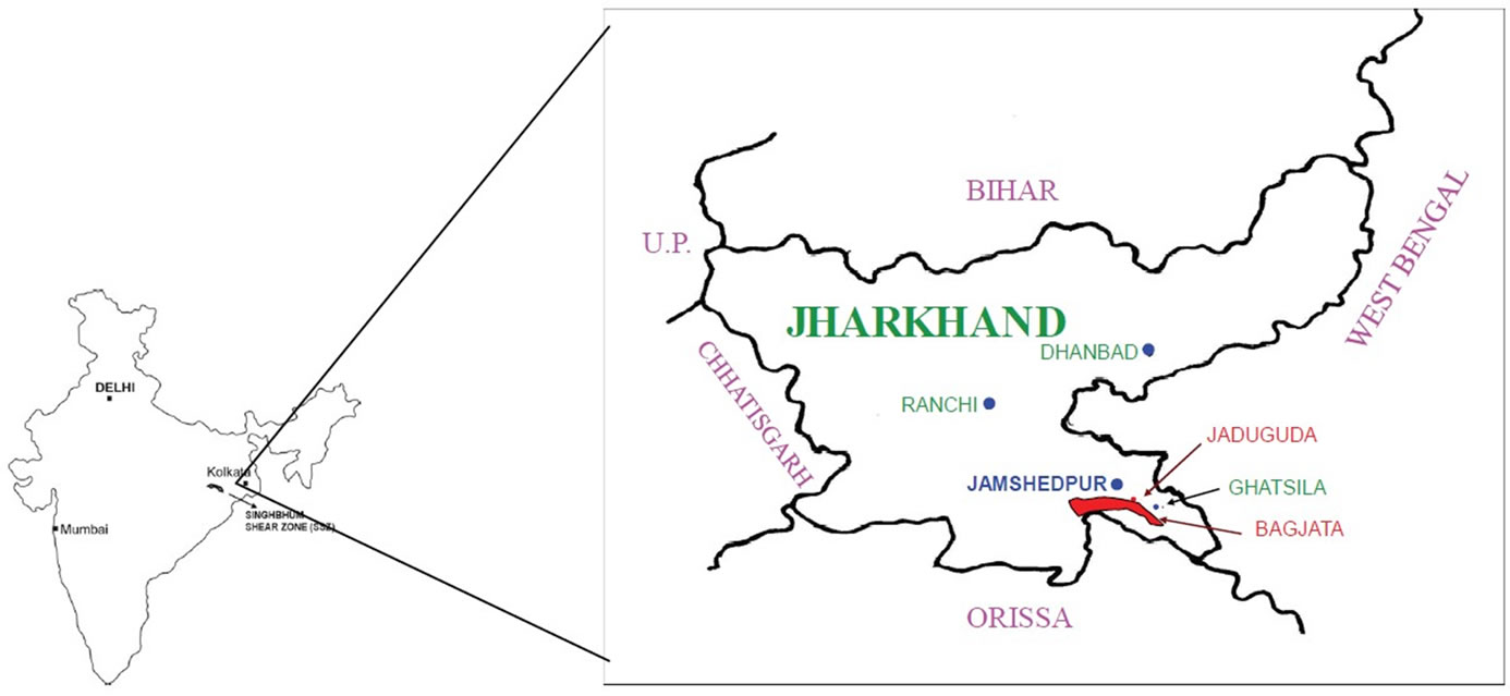
Figure 1. Location of bagjata area, east Singhbhum, Jharkhand, India.
On the basis of field investigations, authors find the area with a gentle to moderately steep or steep slopes. The selected area is to the north and west of a small hill range. The ground level of the area is at 120-144 m RL whereas hilltops to the east are at about 300 m RL and those to the south are mostly at 350-400 m RL. There is another hill range which is within the study zone. These hills are however, less steep and made up of quartzite. General ground level gradually slopes towards the North. The NE quadrant of the area is blocked by Gohala Fault. The natural drainage system is dendritic in nature due to hilly topography and well defined gradients in parts of the study area. The area is very important in terms of lithology and hydrogeological characteristics.
The River Subarnarekha flows from the NW to the SE to the northeast part. The area lies in a valley of about 5 km wide extending in the NW to SE direction. This valley is drained by the Sankh Nalla, which flows northeastern part of the study area and joined the Subarnarekha River 5 km northeast of the Bagjata. Major part of the area has a dendritic drainage pattern.
The hill ranges are drained by seasonal streams which form the part of the Subarnarekha River System. The Sankh Nalla receives water through streams flowing down from the hills on both its banks. High flood level of the Sankh Nalla and Subarnarekha River is well below the study area. The area lies in tropical region where climate is characterized by very hot summer and cold winter. Summer is typically from mid March to mid June when temperature ranges from 44ºC in day to 19ºC in night. Eighty percent of the rainfall occurs during period from mid June to mid September. The average rainfall in the region is 1391 mm as recorded by IMD observatory at Jamshedpur. This paper describes the fluctuations of Ground water with seasons and responses with respect to recharge/discharge. The Geological map was prepared on the basis of field investigations with the help of a modern GPS system. Existing wells were selected for sampling and plotted on this map with the help of AutoCAD software (Figure 2). The selected wells were observed for a period more than a year and data for depth of water level are collected during all the three seasons. The depth to water level data with respect to mean sea level (Table 2) and ground water level contours has been prepared to ascertain the general groundwater hydraulic gradient. An application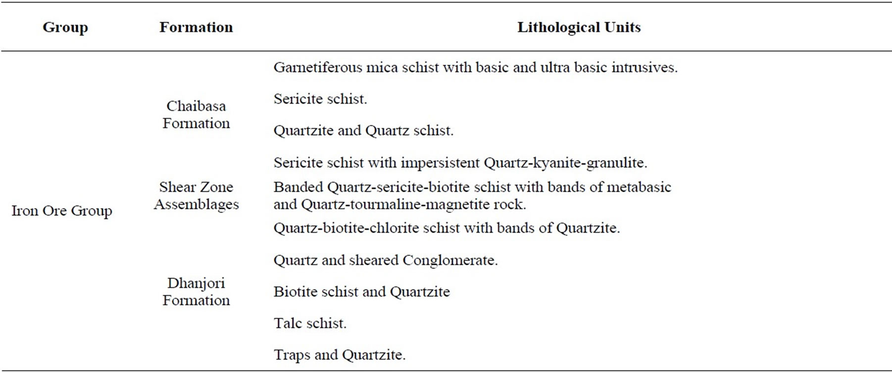
Table 1. Litho-Stratigraphic sequence.
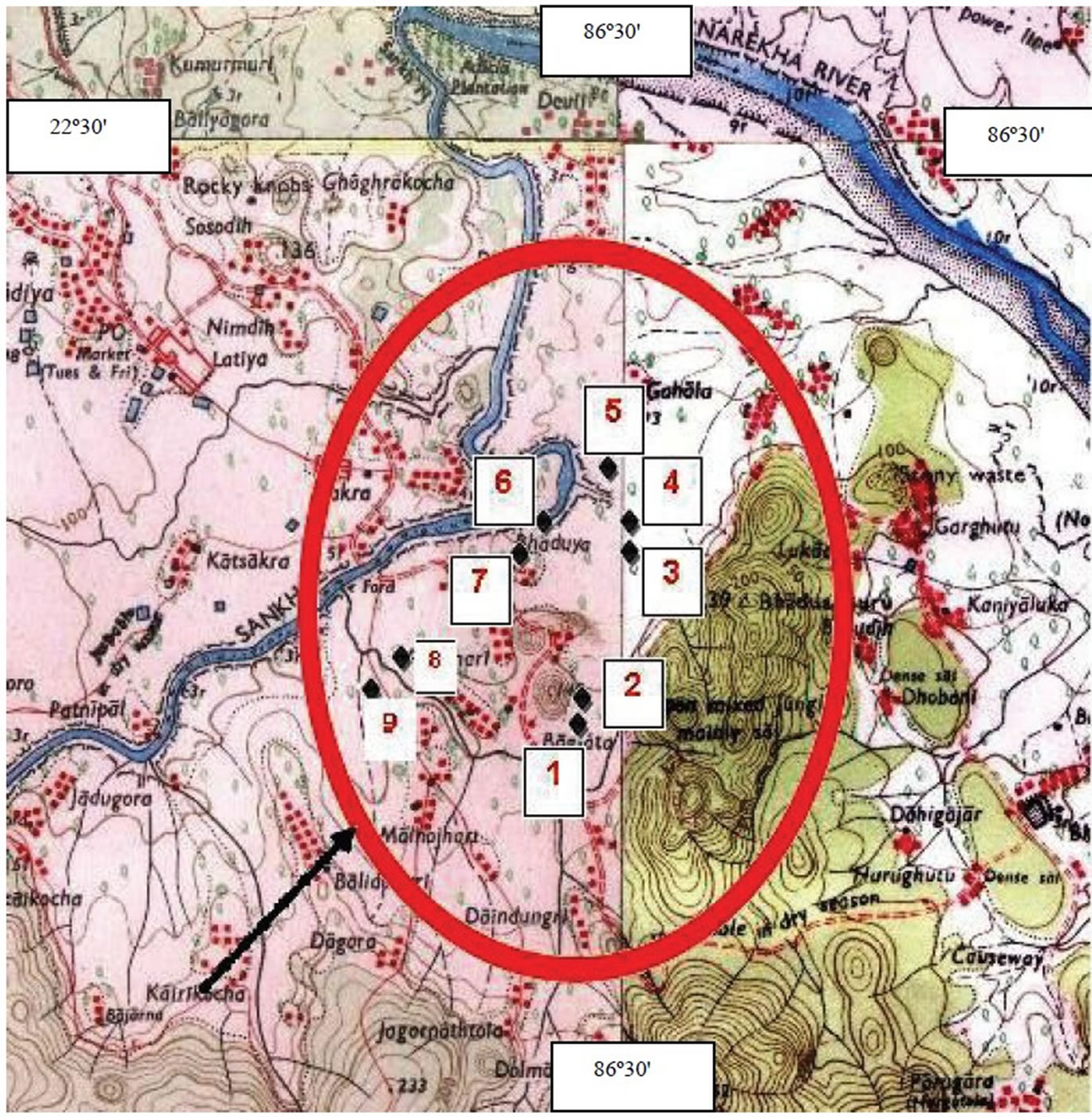
Figure 2. GPS measured sampling locations of Bagjata area, east Singhbhun, Jharkhand.
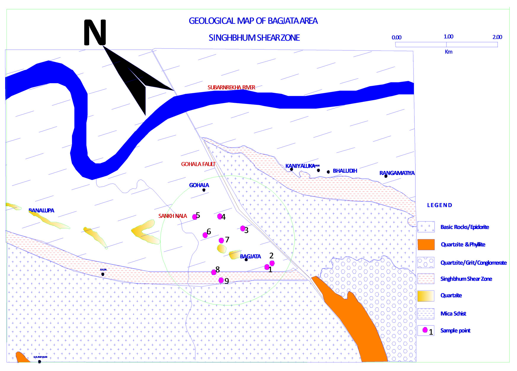
Figure 3. Location of collected samples plotted on the geological map, east Singhbhum, Jharkhand, India.
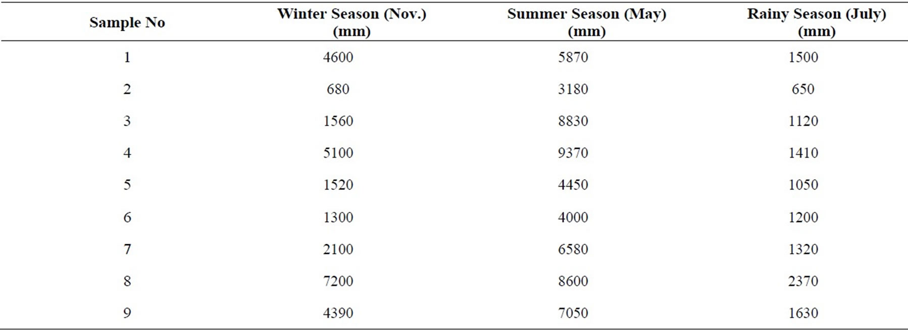
Table 2. Water table (AMSL) at bagjata area.
Groundwater Sampling:
Sampling points are located based on the available open well position in the area and its durability to continue for a long period. The chosen well were monitored for a year in all the three seasons. Table 1 Shows the depth data measured in the three sea sons with respect to the respective reduced level in millimeter (mm). The samples
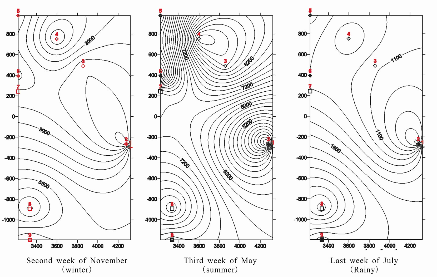
Figure 4. Groundwater level contours at bagjata area, east singhbhum, Jharkhand.
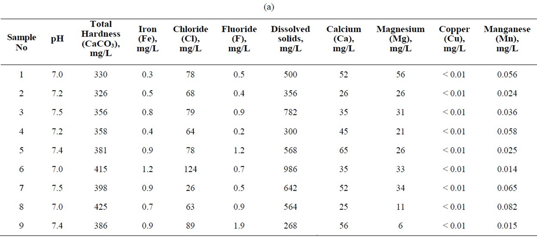
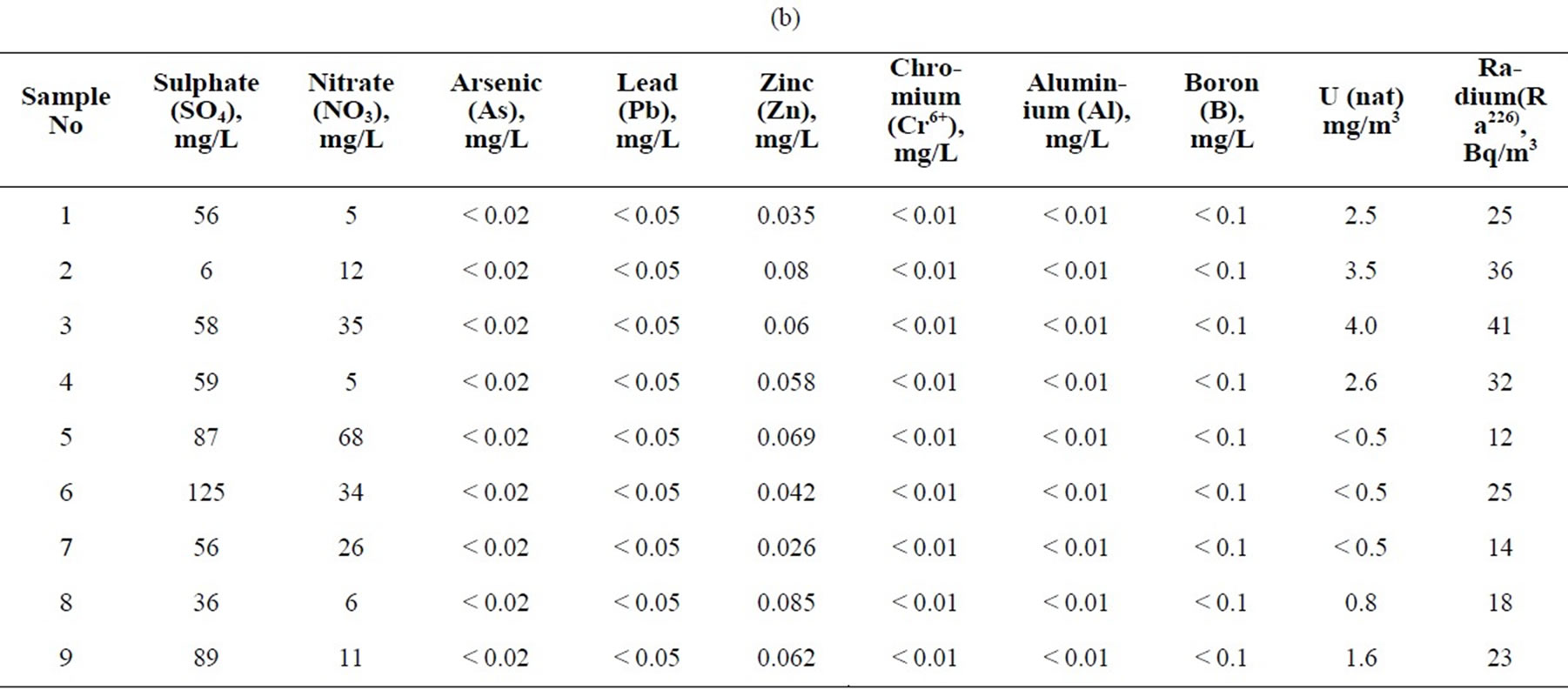
Table 3. (a & b) The chemical composition of groundwater around bagjata area collected during month november.
were also collected from these chosen open well during the winter (November) season. The Poly-ethylene bottles are used for sample collection. Each sample bottle is identified by date, site name and an adhesive bar-code label. The bar-code allows each sample to be tracked through sample analysis and data entry. All bottles for sampling were given the unique bar-code identification number. Collected samples were protected by reducing temperature method to avoid any further contamination, loss or other unintended changes. The sample bottles were completely filled to avoid any evaporation loss. Raw data for all analyses are entered into a Visual dBase database.
3. Hydro-Geochemical Characteristics
The chemical composition of Ground water is shown Table 2. The pH of water samples collected from Bagjata area is mildly alkaline to natural. The most of radicals falls within the permissible limit of drinking water except the Iron content at few locations. The presence of radioactivity is purely due to the Uranium mineral rich area. This value is far beyond the radium activity admissible for drinking waters.
4. Discussion and Conclusions
The collected samples were analyzed for groundwater position, its fluctuation in respect of seasonal variation. Data were first analyzed through manual formation of reduced level and then schematic drawing is formulated with the help of the software for contour generation. Figure 4(a) shows the ground water contour during the winter season where maturity in the domain can be seen easily. Figure 4(b) is the contour diagram of summer season, the dense contour reflects to the scarcity of water in the ground water domain and thus velocity is fast. Figure 4(c) is the contour diagram for rainy season. Again a maturity in the horizon is returned back. Since at any point the water table equals the energy head as a consequence, flow lines lie perpendicular to water table contours. Therefore in all the three season the direction of ground water movement is parallel and sub parallel to North direction which is the direction of Gohala Fault. Gohala Fault is the major discontinuity in the area. Authors find the groundwater movement is very much controlled by the Gohala Fault which is lying along in the N-S direction. Also the wide contour intervals show the higher permeabilities than those of the narrower spacing. Therefore prospects for a good yielding well are better in rainy and winter seasons respectively than in the summer session. Also the major discontinuity in the area that is Gohala fault is very much controlling the flow direction. Authors observe an effluence type of discharge of groundwater where it is in a position to recharge/feed the rivers during all the three seasons. Groundwater quality is mildly alkaline to natural. Radioactive contamination in water is very low and much below the limit. Other radicals are also within the permissible limits and designated safe for drinking. Further it envisages the necessity of such study being undertaken in the entire SSZ belt to secure precise information about the surface manifestations which govern the groundwater recharge potentiality as well as its quality.
5. Acknowledgements
The authors are thankful to the C.M.D. Mr. R. Gupta and Mr. A.K.Sarangi T.S. to the C.M.D. of the Uranium Corporation of India Limited (a Govt. of India Undertaking) at Jaduguda near Jamshedpur for their support and encouragement rendered during the course of the fieldwork. The kind co-operation and necessary infrastructural facilities provided by the Head of the University Department of Geology, Ranchi University, Ranchi (Jharkhand, India) is thankfully acknowledged.
REFERENCES
- A. K. Bannerji, “Cross Folding Migmatisation and Ore Location along Part of the Singhbhum Shear Zone, South of Tatanagar, Bihar,” Economic Geology, Vol. 57, No. 1, 1962 pp. 50-71.
- S. B. Bhattacharjee, A. K. Ghosh, L. Bhattacharjee and S. R. Svananda, “Uranium Mineralisation and Trace Element Distribution in the Jaduguda Uranium Deposit, Singhbhum Thrust Belt, Bihar, Contributions to the Geology of Singhbhum,” Jadavpur University, Calcutta, 1966, pp. 59-75.
- S. B. Bhattacharjee, A. K. Ghosh, L. Bhattacharjee and S.
- Bhattacharjee, “Minor Elements in Some Rocks and Minerals of the Rakha Mines Area, Singhbhum, India,” Mineralogical Magazine, Vol. 36, No. 281, 1968, pp. 671- 675.
- K. L. Bhola, G. R. Udas, N. R. Mehta and G. H. Sahasrabudhe, “Uranium Ore Deposits at Jaduguda in Bihar State India,” In: Peaceful Uses of Atomic Energy, Proceedings of Second Internet Conference, Vol. 2, 1958, pp. 704-708.
- J. A. Dunn and A. K. Dey, “Geology and Petrology of Eastern Singhbhum and Surrounding Areas,” Memoirs of Geological Survey, India, Vol. 69, No. 2, 1942.
- J. M. McDonald and A. W. Harbaugh, “A Modular Three-Dimensional Finite-Difference Groundwater Flow Model. Techniques of Water Resources Investigations of U.S.,” Geological Survey Book, 1988, p. 586.
- H. M. Ragunah and D. K. Todd, “Ground Water,” In: H. M. Raghunath and D. K. Todd, Eds.
- S. C. Sarkar, “Geology and Ore Mineralisation of the Singhbhum Copper-Uranium Belt, Eastern India,” INA Press, Kolkata, 1985.