Journal of Geographic Information System
Vol.6 No.2(2014), Article ID:44562,9 pages DOI:10.4236/jgis.2014.62009
Soil Mapping of a Small Watershed in a Brazilian Savanna Biome: A Semi-Automatic Approach
Larissa Ane de Sousa Lima1, Adriana Reatto2, Henrique Llacer Roig1
1Geosciences Institute, University of Brasilia, Brasilia, Brazil
2Centro de Pesquisa Agropecuária do Cerrado, Empresa Brasileira de Pesquisa Agropecuária, Brasilia, Brazil
Email: larissa.ane@unb.br, reatto@cpac.embrapa.br, roig@unb.br
Copyright © 2014 by authors and Scientific Research Publishing Inc.
This work is licensed under the Creative Commons Attribution International License (CC BY).
http://creativecommons.org/licenses/by/4.0/


Received 31 January 2014; revised 28 February 2014; accepted 7 March 2014
ABSTRACT
The objective of this work is to propose a semi-automatic methodology for the creation of a semidetailed to detailed watershed’s soil map. This methodological proposal is based on the traditional method (field work and photo interpretation) and on morphometric variables analysis, using data originated from the Digital Elevation Model (DEM) of the Shuttle Radar Topography Mission (SRTM) program. The steps taken through this methodological proposal were the identification of the hydromorphic areas boundaries through interpretation of aerial orthophotographs; the compartmentalization of the relief through color composition techniques using the morphometric variables—slope, altimetry and horizontal curvature; the development of a pedological database based on data gathered in the field; the elaboration of a preliminary soil map based on the compartmentalized relief and on the dataset of the soils sampled in the field; the elaboration and adjustment of the final soil map according to the interpretation of aerial photographs and also the physical and chemical analyses of the soils. This semi-automatic methodology demonstrated improved efficiency in defining the soil units, reducing operation time and subjectivity of the process, thereby contributing to the systematization of soil mapping at watershed level in scale 1:50,000, as well as, promoting better knowledge between the relation of the geomorphic and soil variables in the Brazilian Savanna Cerrado.
Keywords:Semi-Automatic Mapping, SRTM, Morphometric, Pedological Maps

1. Introduction
Currently, the traditional mapping of soils has been criticized for being time consuming and costly. In response to these criticisms, new approaches have been proposed and developed to improve the mapping of soils and their attributes [1] [2] .
The relief is one of the factors of soil formation, exerting a great influence on its genesis and on its distribution in the landscape [3] . According to [4] , the relief presents a strong relationship with the boundaries of soil map units. Therefore, these pedological units can be obtained through morphological interpretation of satellite images, or aerial orthophotographs. In addition, geomorphological compartmentalization has been applied as a compliment to soil mapping, to optimize field work and to make the identification of unit boundaries more precise [5] -[7] .
Faced with the difficulties in establishing a system that describes all of the complexity of the relief, innumerable methods to describe and analyze reliefs have been developed [8] . Notable procedures include morphometric relief analysis using Geographic Information Systems (GIS), [7] .
The growing application of semi-automatic methods is mainly due to the increase in the availability of Digital Elevation Models (DEM), allowing us to better understand the organization of the landscape and infer behaviors from other parameters, such as, the climatic characteristics [9] , the attributes of the soil [10] and plant distribution [11] . The morphometric attributes have also been used for the geomorphic compartmentalization [12] as well as pedological [13] . In Central Brazil, many studies have been done using morphometric analysis for pedogeomorphologic mapping. Among these, the most important are: [5] -[8] [14] -[20] .
In this context, the objective of this paper is to propose improvements to the semi-automatic method based on joining the traditional method (field work and interpretation) with the analysis of morphometric variables derived from the DEM of the Shuttle Radar Topography Mission (SRTM) to obtain a soil map scale >1:50,000 in a watershed in the Cerrado biome.
2. Material
2.1. Characteristics of the Study Area
The area selected to carry out this study was the Sarandi Basin—30 km2, located in the Federal District of Brazil. The Sarandi Basin was selected for this study due to the fact that it is an experimental basin and because it presents the typical characteristics of the Brazilian Central Plateau Eco-region (Figure 1).
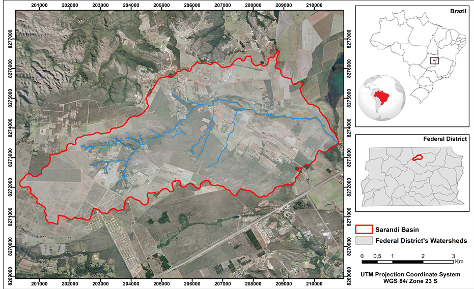
Figure 1. Map of the location of the Sarandi basin.
The natural vegetation of the basin area is a typical savanna biome. Approximately 40% of the area still has its natural cover. The dominant phytophysionomy is savanna, although gallery forests, grasslands and trails can be found in some small sections and fragmented areas [21] .
According to the Köppen classification, the most representative climate of the Central Plateau is Megatermic or Humid Tropical (Aw) with the subtype savanna. It is characterized by high precipitation in the summer (between November and January), and low precipitation in the winter (between June and August). Annually, the precipitation varies around 1500 mm, concentrated between September and April. The yearly average temperature is 20˚C [22] .
The characteristic geology of the Sarandi basin is composed of clay and sandy metarrithmite, and psamo-pelitic carbonate, from the Paranoá Group [23] .
Regarding the Geomorphology, this basin can be divided into four main components: plateau, characterized by a flat to rolling-undulating relief, with altimetric rates varying between 1200 to 1100 meters; erosive retreat fronts, that represent the edges of the plateaus, rugged and craggy in some places, accentuating the break in the relief; colluvium ramps, with smooth conformity and at altitudes between 800 and 900 meters; and hydromorphic areas near the drainage areas [24] .
In general, the Sarandi basin is composed of natural and anthropic areas, the dominant agriculture of the plateau being drought based; irrigated agriculture is developed on the colluvium ramps; and the most preserved part of the basin is located on the erosive retreat fronts, which are permanent reserve areas of the Embrapa Cerrados.
2.2. Data Base
The following topographic variables (altimetry, slope gradient, aspect, contour curvature and profile curvature) were used in this study to characterize the environmental conditions. The selection of these topographic variables is based on the fact that the area is small (30 km2) and the macro-climate is fairly similar throughout the entire area. Moreover, micro-climate conditions are easily obtained using the topographic conditions captured by the topographic variables used [13] . These variables were taken from the Geomorphometric Database of Brazil [25] , which is available through the Topodata Project (www.dsr.inpe.br/topodata/index.php). This DEM is derived from the set of geostatistical coefficients suitable for a unified Shuttle Radar Topography Mission data (SRTM) refinement from 3 arc-seconds to 1 arc-second through kriging methodology [25] . The high resolution mosaic of aerial orthophotographs (1:10,000 - 0.5 m resolution) was provided by Terracap (Realty Company of Brasília). In addition, the soil field data used in this study is from the Soil Maps of the Brazil [26] -[29] , and obtained through field work in this research.
3. Methods
The methodological procedures used in the mapping process are presented in Figure 2.
3.1. Compartmentalization of the Relief through the Analysis of the Morphometric Parameters
The purpose of the compartmentalization of the Sarandi basin relief was to improve the methodology proposed in [5] [30] .
The first step was the delineation of the boundaries of the hydromorphic areas that were identified through the photointerpretation of high resolution aerial orthophotographs (1:10,000) (Figure 3(a)). This result was checked and validated in the field. This step is very important, because the methodology proposed by [5] was not efficient in detecting hydromorphic areas on the Sarandi basin. The delineation of these regions is important for the classification of the hydromorphic soils.
The second step is to create triplet compositions (RGB images—Figure 3(b)) combining topographic variables. These compositions, with morphometric attributes, are a way to synthesize a large quantity of information in a single image. Moreover, the composition makes it possible to distinguish the units of relief through variations in color and texture [5] -[7] [14] . A triplet composition functions well to delimit the geomorphological units when the relief is the stratifying element of the landscape, and when it works with low hierarchical levels without compromising a more detailed level (high level).
Afterward, a mask was done on the RGB composition with hydromorphic areas mapped (Figure 3(c)), so that
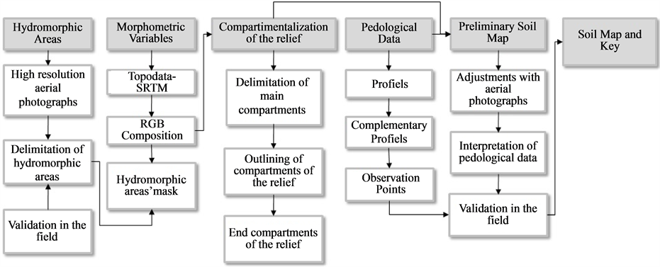
Figure 2. Procedures carried out for the development of the soil map and the detailed key for the Sarandi basin—Federal District.
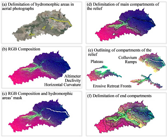
Figure 3. Procedures used in the geomorphological compartmentalization of the Sarandi basin—Federal District
these areas would not interfere in the histogramic outlining of the features of the relief that had not yet been carried out in the colored compositions.
In the case of the Sarandi experimental basin, to create the RGB compositions, the altimeter and slope variables are fixed to the red and green channels respectively. While within the blue channel, the variables were alternated between the aspect, and the vertical and horizontal curvatures. The compositions were compared and just one was selected for the compartmentalization of the relief. After analyzing all of the possibilities, the triplet that best outlined the relief was the: altimeter in the red channel (R); slope in the green channel (G); and horizontal curvature in the blue channel (B) (Figure 3(b)). This composition shows the main compartmentalization of the relief. The compartmentalization of the relief was carried out based on the visual interpretation of the colored composition, where, firstly, three main parts were delimited: plateau, erosive retreat fronts, and colluvium ramps (Figure 3(d)).
After that, the next step was the development of a new triplet, with the same variables (altimetry, slope, and horizontal curvature), for each one of the three main constituents of the relief (Plateau, Erosive retreat front and Colluviums ramps), (Figure 3(e)). This procedure provided better outlining of the features of the relief at the higher level. In each main unit of the relief, new constituents of classes of soil were delineated and identified in detailed scale (Figure 3(f)) for a watershed in the Central Plateau Eco-region where the landscape stratification constitutes the relief.
3.2. Development of the Pedological Data Base
The pedological data base used for the development of the soil map was comprised of 13 profiles of soil within the area delimited by this study, which was derived from bibliographic research [26] -[29] and data collected in the field: 38 complementary profiles collected in five depths (from 120 cm depth) and 35 observation points. Planning procedures for the field work included the compartmentalization of the relief, which was used as a support to guide the gathering of complementary profiles according to the constituents. The profiles collected in the field underwent chemical and physical analysis, and were classified up to the third level category of the Brazilian System of Soil Classifications (SiBCS) [31] , and were correlated with World Reference Base [32] . Table 1 presents a summary of the pedological data base. For a complete description of the data, as well as the details about collection, results and classification, consult [8] .
3.3. Development of the Soil Map and Key
For the development of the soil map, the delimitation of the mapping units was based on the compartmentalization of the relief. The profiles and the complementary profiles were plotted on the compartmentalization of the relief and each polygon was classified with the class of corresponding soil. Next, the visual interpretation of the aerial orthophotographs was carried out with a resolution of 10 meters, which aided in refining the limits between the classes of soil and the differentiation of the classes of vegetation. For the final adjustments to the map, observation points were used, facilitating the identification of the transition zones between some classes of soil and the clarification of the boundaries between the mapping units.
For the development of the key, chemical and physical data were used, as well as field information of the profiles and complementary profiles that constituted the soil data bases. The soils were classified up to the third level of the Brazilian System of Soil Classification [31] and correlation with World Reference Base [32] . The mapping units from the same class of soil with the texture classes of the relief or vegetation were differentiated in the key by a sequential number.
4. Results and Discussion
The proposed methodology made it possible to compartmentalize the relief on the first level, with three divisions, and on the second level with 22 divisions. These divisions, combined with the soil data and the interpretation of

Table 1. Soil data base used for the development of the soil map in the Sarandi basin.
a. Brazilian Soil Taxonomy [31] , LV: Latossolo Vermelho; LVA: Latossolo Vermelho Amarelo; LA: Latossolo Amarelo; CX: Cambissolo Háplico; FF: Plintossolo Pétrico; FX: Plintossolo Háplico; RQ: Neossolo Quartzarênico; GM: Gleissolo Melânico; GX: Gleissolo Háplico. b. World Reference Base [32] , FR: Rhodic Ferralsol; FO: Orthic Ferralsol; FX: Xanthic Ferralsol; CH: Haplic Cambisol; PP: Petric Plinthosol; PH: Haplic Plinthosol; AO: Haplic Arenosol; GM: Mollic Gleysol; GO: Haplic Gleysol.
the high resolution aerial orthophotography, allowed us to develop a soil map and key of the Sarandi basin on a scale of 1:30,000.
Two soil maps were developed. In the first map it was possible to identify seven classes of soil, classified up to the second level of the SiBCS [31] , Latossolo Vermelho (42.07%), Latossolo Vermelho-Amarelo (22.46%), Latossolo Amarelo (15.09%), Cambissolo Háplico (9.83%), Neossolo Quartzarênico (0.07%), Gleissolo Melânico (0.52%) and Gleissolo Háplico (9.92%), (Figure 4).
On the second map, (Figure 5), 23 mapping units were identified, classified up to the third level category of the SiBCS [31] , according to relief class and vegetation class.
The compartmentalization of the relief does not allow the distinction of the hydromorphic areas and consequently of the classes of hydromorphic soils, Gleysols and Plinthosols, which were identified through the visual interpretation of aerial orthophotographs. Meanwhile, the methodology used facilitated the identification and the delimitation of the mapping units, decreasing efforts needed in the field and in the mapping. It even allowed the integration of the landscape data and the comprehension of the organization and distribution of the soil according to the relief soil associations.
The methodological proposal presented here constitutes a mixed mapping technique, with the use of traditional mapping and digital soil mapping techniques, promoting advances in the methodological procedures for the development of soil maps. Table 2 presents some advantages and disadvantages in the methodology proposed.
5. Conclusions
1) The semiautomatic methodology presented in this study used the association of SRTM data for the compartmentalization of the relief, and the interpretation of high resolution aerial orthophotographs for the identification and the delimitation of the soil mapping units, streamlining the process utilized in other methods.
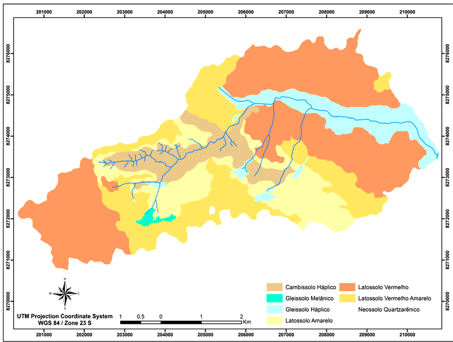
Figure 4. Soil map from the Sarandi basin with simplified key in 1:30,000 scale.
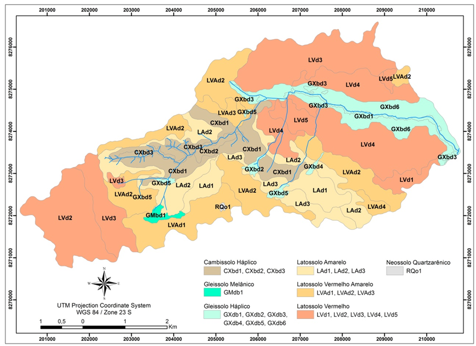
Figure 5. Soil map of the Sarandi basin in a scale of 1:30,000.
Table 2. Advantages and disavantages of semi-automatic soil mapping.
2) The association of sensor data with the interpretation of the high resolution aerial orthophotographs was necessary because the data generated for the compartmentalization of the relief by colored composition did not present enough resolution to separate the hydromorphic areas.
3) The semiautomatic methodology proposed in this study can also be considered as a semi-traditional methodology that combines automatic techniques for the distinction of classes (compartmentalization of the relief based on the procession of morphometric images) with the perceptive procedures of interpretation and delimitation of polygons, as in traditional methods of soil mapping.
4) This proposal improves the integration of data, increasing understanding of the organization and distribution of soils in the landscape.
Acknowledgements
The authors would like to thank: the Graduate program in Applied Geosciences and Capes for the grant awarded to the first author during the development of his Master’s degree; the Sensoriamento Remoto e Analise Espacial (LSRAE) laboratory of the IG/UnB for providing computational infrastructure; the ESRI for providing the tool packet that comprised the ArcGis 10 Family through the contract No 2011 MLK 8733, and IMAGEM for the support and for making viable and concrete the term of use between IG and ESRI and for the software support; the Embrapa Cerrados, where this study was carried out in the GeoCerrado Project titled Modeling of the Geoenvironmental Variables for the Characterization of Environmental Services in the Savanna Biome (Project 02.10.01.015.00).
References
- McBratney, A.B., Odeh, I.O.A., Bishop, T.F.A., Dunbar, M.S. and Shatar, T.M. (2000) An Overview of Pedometric Techniques for Use in Soil Survey. Geoderma, 97, 293-327. http://dx.doi.org/10.1016/S0016-7061(00)00043-4
- McBratney, A.B., Mendonça Santos, M.L. and Minasny, B. (2003) On Digital Soil Mapping. Geoderma, 117, 3-52. http://dx.doi.org/10.1016/S0016-7061(03)00223-4
- Jenny, H. (1941) Factors of Soil Formation: A System of Quantitative Pedology. McGraw-Hill Book Company Inc., New York.
- Goosen, D. (1968) Interpretacion de fotos aereas y su importancia em levantamiento de suelos. Organizacion Naciones Unidas y para la Agricultura y la Alimentacion, Roma.
- Hermuche, P.M., Guimarães, R.F., Carvalho, A.P.F., Martins, E.S., Fuks, S.D., Carvalho Junior, O.A., Santos, N.B.F. and Reatto, A. (2002) Morfometria como Suporte para Elaboração de Mapas Pedológicos: I. bacias hidrográficas assimétricas. Série Documentos Embrapa Cerrados, 68, 25 p.
- Panquestor, E.K., Carvalho Junior, O.A., Leal, L.R., Andrade, A.C., Martins, E.S. and Guimarães, R.F. (2002) Associação do Processamento Digital de Imagens ao Uso de Parâmetros Morfométricos na Definição de Unidades de Paisagem da Bacia do Rio Corrente-BA. Espaço e Geografia, 5, 87-99.
- Borges, M.E.S., Carvalho Junior, O.A., Martins, E.S., Arcoverde, G.F.B. and Gomes, R.A.T. (2007) Emprego Do Processamento Digital de Parâmetros Morfométricos no Mapeamento Geomorfológico da Bacia do Rio Preto. Espaço e Geografia, 10, 401-429.
- Lima, L.A.S. (2013) Aplicação dos Métodos Semi-Automático e LógicaFuzzy para o Mapeamento Pedológico da Bacia do Sarandi. Master’sThesis, University of Brasília, Brasília.
- Daly, C., Neilson, R.P. and Phillips, D.L. (1994) A Statistical-Topographic Model for Mapping Climatological Precipitation over Mountainous Terrain. Journal of Applied Meteorology, 33, 140-158. http://dx.doi.org/10.1175/1520-0450(1994)033<0140:ASTMFM>2.0.CO;2
- Iwashita, F., Friedel, M.J., Ribeiro, G.F. and Fraser, S.J. (2012) Intelligent Estimation of Spatially Distributed Soil Physical Properties. Geoderma, 170, 1-10. http://dx.doi.org/10.1016/j.geoderma.2011.11.002
- Bispo, P.C., Valeriano, M.M. and Kuplich, T.M. (2010) Relação Entre as Variáveis Morfométricas Extraídas de Dados SRTM (Shuttle Radar TopographyMission) e a Vegetação do Parque Nacional de Brasília. Acta Botanica Brasilica, 24, 96-103. http://dx.doi.org/10.1590/S0102-33062010000100010
- Vasconcelos, V., Carvalho Júnior, O.A., Martins, E.S., Couto Júnior, A.F., Guimarães, R.F. and Gomes, R.A.T. (2012) Sistema de Classificação Geomorfométrica Baseado em uma Arquitetura Sequencial em Duas Etapas: Árvore de decisão e classificador espectral, no Parque Nacional Serra Da Canastra. Revista Brasileira de Geomorfologia, 13, 171- 186.
- Zhu, A.X., Yang, L., Li, B., Qin, C., Pei, T. and Liu, B. (2010) Construction of Membership Functions for Predictive Soil Mapping Under Fuzzy Logic. Geoderma, 155, 164-174. http://dx.doi.org/10.1016/j.geoderma.2009.05.024
- Lima, L.A.S., Martins, E.S., Reatto, A., Castro, K.B., Souza, V.V. and Carvalho Junior, O.A. (2009) Compartimentação Geomorfológica e suas Relações com Solos na Bacia do Alto Rio Preto, GO. Boletim de Pesquisa Embrapa Cerrados, 255, 24 p.
- Castro, K.B., Martins, E.S., Gomes, M.P., Reatto, A., Lopes, C.A., Passo, D.P., Lima, L.A.S., Cardoso, W.S., Carvalho Junior, O.A. and Gomes, R.A.T (2010) Caracterização Geomorfológica do Município de Luís Eduardo Magalhães, Oeste Baiano, Escala 1:100.000. Boletim de Pesquisa Embrapa Cerrados, 288, 33 p.
- Lima, L.A.S., Martins, E.S., Gomes, M.P., Reatto, A., Lopes, C.A., Passo, D.P., Castro, K.B., Cardoso, W.S., Carvalho Junior, O.A. and Gomes, R.A.T. (2010) Caracterização Geomorfológica do Município de Riachão das Neves, Oeste Baiano, escala 1:100.000. Boletim de Pesquisa Embrapa Cerrados, 295, 35 p.
- Neumann, M.R.B. (2012) Mapeamento digital de solos no Distrito Federal. Ph. D. Thesis, University of Brasilia, Brasilia.
- Neumann, M.R.B., Roig, H.L. and Souza, A.L.F. (2012) Digital Elevation Models Obtained by Contour Lines and SRTM/Topodata, for Digital Soil Mapping. Journal of Soil Science and Environmental Management, 3, 104-109.
- Lacerda, M.P.C. and Barbosa, I.O. (2012) Relações Pedomorfogeológicas e Distribuição de Pedoformas na Estação Ecológica de Águas Emendadas, Distrito Federal. Revista Brasileira de Ciência do Solo, 36, 709-721. http://dx.doi.org/10.1590/S0100-06832012000300003
- Barbosa, I.O., Lacerda, M.P.C. and Billich, M.R. (2010) Soils Distribution Model Based on Relation between Geology, Geomorphology and Pedology, at the High Plateau of Distrito Federal, Brazil. Revista de la Asociación Geológica Argentina, 66, 569-575.
- Ribeiro, J.F. and Walter, B.M.T. (2008) As Principais Fitofisionomias do Bioma Cerrado. In: Sano, M.S., Almeida, S.M. and Ribeiro, J.F., Eds., Cerrado: Ecologia e flora, Embrapa Cerrados, Planaltina, 152-212.
- Fonseca, C.P., Gomes, A.C.C., Figueiredo, G.M.L., Joveli, J.C., Soares, L.C. and Toledo, S.P. (2010) Diagnóstico da Sub-bacia do Ribeirão Mestre d’Armas por Meio de Dois Métodos de Avaliação Ambiental Rápida, Distrito Federal, Brasil Central. Ambiente & Água, 5, 43-56.
- Campos, J.E.G. and Freitas-Silva, F.H. (1998) Geologia do Distrito Federal. In: Inventário Hidrogeológico e dos Recursos Hídricos Superficiais do Distrito Federal, IEMA/SEMATEC/UnB, Brasília, Vol. 1, Parte I. 86 p.
- Messias, A., Reatto, A., Martins, E.S., Couto Jr., A.F., Prado, M., Vasconcelos, V., Souza, J.P.S. and Neves, G. (2013) Aplicação de Multisensores para a Compartimentação Geomorfológica de uma Bacia Hidrográfica do Bioma Cerrado. Encontro de Iniciação Científica da Embrapa Cerrados: Jovens Talentos, Brasília, p. 49.
- Valeriano, M.M. and Albuquerque, P.C.G. (2010) TOPODATA: processamento dos dados SRTM. INPE, São Jose dos Campos.
- Brasil-Ministério da Agricultura-Escritório de Pesquisas e Experimentação (1967) Levantamento semidetalhado dos solos de áreas do Ministério da Agricultura no Distrito Federal. Boletim, No. 8, 127 p.
- Empresa Brasileira De Pesquisa Agropecuária-EMBRAPA (1978) Levantamento de reconhecimento dos solos do Distrito Federal. Boletim Técnico, No. 53, 455 p.
- Reatto, A., Bruand, A., Martins, E.S., Muller, F., Silva, E.M., Carvalho Jr., O.A., Brossard, M. and Richard, G. (2009) Development and Origin of the Microgranular Structure in Latosols of the Brazilian Central Plateau: Significance of Texture, Mineralogy, and Biological Activity. Catena, 76, 122-134. http://dx.doi.org/10.1016/j.catena.2008.10.003
- Reatto, A., Bruand, A., Silva, E.M., Martins, E.S. and Brossard, M. (2007) Hydraulic Properties of the Diagnostic Horizon of Latosols of a Regional Toposequence across the Brazilian Central Plateau. Geoderma, 139, 51-59. http://dx.doi.org/10.1016/j.geoderma.2007.01.003
- Messias, A., Reatto, A., Couto, A.F., Martins, E.S., Prado, M. and Souza, J.P.S. (2012) Caracterização Geomorfológica da Bacia Experimental do Sarandi, DF, escala 1:25.000. Encontro de Iniciação Científica da Embrapa Cerrados: Jovens Talentos, Brasília, 47.
- Empresa Brasileira De Pesquisa Agropecuária-EMBRAPA (2009) Sistema Brasileiro de Classificação de Solos. Embrapa Solos, Rio de Janeiro.
- IUSS Working Group WRB (2006) World Reference Base for Soil Resources 2006. World Soil Resources Reports No. 103, FAO, Rome.