International Journal of Geosciences
Vol.08 No.08(2017), Article ID:78446,16 pages
10.4236/ijg.2017.88054
Assessment of Geotechnical Properties of Lateritic Gravels from South-Cameroon Road Network
Philémon Zo’o Zame1, Philippe Samba Assomo1*, Josephine Nchekwube Onwualu2
1Department of Earth Sciences, Faculty of Science, University of Yaoundé I, Yaoundé, Cameroon
2Department of Geology, University of Port Harcourt, Port Harcourt, Nigeria

Copyright © 2017 by authors and Scientific Research Publishing Inc.
This work is licensed under the Creative Commons Attribution International License (CC BY 4.0).
http://creativecommons.org/licenses/by/4.0/


Received: June 21, 2017; Accepted: August 11, 2017; Published: August 15, 2017
ABSTRACT
The southern road network covers the eastern, central and southern administrative regions; its linear network of national and provincial roads is about 5 620 km. It was the subject of a survey for the identification of lateritic quarries. To this effect, 144 sites have been discovered. The collected lateritic gravels were subjected to identification analyzes (Granulometry, Atterberg Limits, densimetry, water content) and geotechnical characterization tests (Proctor Modified, CBR at 95% OPM). The obtained results show that the grain size has a great percentage of gravels (>60%) followed by sand. Stones silt and clay particles are poorly represented. The samples show a high plasticity in conformity with Casagrande’s plasticity diagram. The density values of the solid particles (γs) are quite stable in the studied area and vary between 26 and 29 KN/m3 for a natural water content comprised between 10% and 20%. The modified proctor test gives an optimal water value (Wop %) comprised between 8% and 12%. Dry density values (γd) varied between 18 and 30 KN/m3. The bearing capacity of the materials is good (30 < CBR < 90). These results permit the recommendation of the studied materials as foundation layers of roads for traffic classes between T1-T4.
Keywords:
Properties, Lateritic Gravel, Tests, Geotechnical Characterization, Foundation Layers

1. Introduction
Within the framework of the program of putting in place of a map of lateritic deposits and quarries in Cameroon, jointly piloted by LABOGENIE (National Laboratory of Civil Engineering) and MINTP (Ministry of Public Works), the road network of southern Cameroon has been covered. The aim of this study is to collect a data bank for geotechnical characteristics of lateritic gravels so as to provide quality materials for better road construction. This study is a first step in the concretization of this important project. The work consists of referencing the various lateritic deposit sites identified along the road side, to carry out their complete characterization and to indicate the place of the materials in the road construction, in the light with their properties. This work is in line with the importance attributed to lateritic gravels for road construction in tropical countries where lateritic soils often develop [1] . More often, in road structures, gravels are advised to be used as foundation or base layers [2] [3] [4] . Grain size distribution and the load bearing capacity are the first indices of their choice [5] [6] [7] . Lateritic gravels equally have the advantage of good porous properties whereby they are often used as pavements for road surfacing [8] . In Cameroon, recent works have been carried on geology, geotechnical and mechanical characterisation of lateritic gravels in South Cameroon [9] and East Cameroon [10] . Unfortunately, these works have maintained a very punctual character and the number of samples has not been of interest in the road network. The present study will enable intensive sampling in the road network and make available an important data bank concerning the studied gravels so as to know their place in road construction work.
2. Geological Setting
The Ministry of Public Works of Cameroon has subdivided the road infrastructure into three major networks: Northern, Western and Southern. The Southern network (Figure 1) which is the main focus of this work covers the administrative regions of the Centre, East and South. It is limited to the North by the Adamawa region, to the West by the Atlantic Ocean, to the East by the Central African Republic (CAR) and to the South by Equatorial Guinea, Gabon and Congo. According to [11] , the study area belongs of three climatic zones: 1) the equatorial climate with four seasons, 2) the coastal equatorial climate and 3) the equatorial and tropical transition climate. The common characteristic of these climates is the presence of dense forest vegetation with some peri-forest savannas. The basement in the study area is mostly made up of metamorphic rocks such as gneiss, schists and quartzites as well as plutonic rocks particularly granites and associated rocks [12] . These rocks are often made up of varied mineral associations. However, they all have high contents in silica and aluminum [13] . Tectonically, this basement is characterized by a network of fractures. The compact nature of these formations render them as very good materials for civil engineering especially in road and house construction [14] . The soils are “ferralitic” and are characterized by a thick layer of a weathering mantle whose lateritic gravels constitute their specific products [15] . These soils develop on a basement which belongs either to the Congo craton, the mobile zone or to the sedimentary

Figure 1. Location of study sites.
basins [12] . The lowlands are mainly covered by hydromorphic soils [16] .
3. Materials and Methods
The linear of the road network in South Cameroon enabled the indexing of 144 lateritic gravel sites with 44 in the South region, 50 in the Centre region and 50 in the East (Figure 1). Layered gravels are often discontinuous. Thus, the research methodology consisted of: 1) identifying favorable areas a priori; 2) realization of three to five wells according to an estimable surface to determine the thickness of the lateritic gravel and the exploitable power of the lateritic borrowing and finally take the samples for carrying out the tests in the laboratory. Wells have been opened to an average depth of 2.50 m (Figure 2). For borrowings sites already operated, the material was taken either from the slopes, in wells with an average depth of 1.0 m or in abounding heaps. A minimum of three (03)

Figure 2. Geological sketch section of the studied lateritic gravels. LG: lateritic gravels.
withdrawals were made by borrowing area, for a total weight of 150 kg. The samples taken from the field were transported to LABOGENIE (Yaoundé, Cameroon) to carry out tests according to the French standards [17] [18] [19] [20] [21] . The results of mineralogy and geochemistry were obtained thank to the anterior works conducted on the area.
4. Results
4.1. Mineralogy
The lateritic gravels of South Cameroon are mainly made up of quartz, kaolinite, hematite, goethite and muscovite [9] [13] [22] and accessory amounts of anatase and ilmenite (Table 1).
4.2. Geochemistry of Major Elements
Past works [9] [10] [13] [22] has enabled the explanation of the distribution of major elements in the lateritic gravels of the South, Centre and East regions. Three main oxides consisting of silica, alumina and iron show high contents (Table 1). Evaluation of the average content of oxides in South Cameroon show that silica is the most abundant oxide (37.04 wt.%) followed by iron (32.43 wt.%) and aluminum (17.04 wt.%). Binary diagrams built give the distribution of these main oxides (Figures 3(a)-(c)).
4.3. Grain Size Distribution
Grain size analysis enabled the establishment of grain curves. Tables 2-4 show the percentage of particles in sieves with varied sizes in the three regions concerned. Figure 4 shows derived grain size distribution curves. These curves show

Table 1. Mineral assemblage and major element distribution.
Notes: E1, E2: East sample’s number; S1, S2, S3, S4, S5, S6, S7, S8, S9: South sample’s number; C1, C2, C3, C4, C5: Centre sample’s number; AV.1, AV.2, AV.3, AV.: 1st, 2nd, 3rd and General Average respectively; n.a: unanalyzed element, Min: mineralogy; Q: Quartz; K: Kaolinite; H: Hematite; Go: Goethite; A: Anatase; Gi: Gibbsite; M: Muscovite.
Table 2. Grain size analysis (south region).
n: sample’s number.
Table 3. Grain size analysis (centre region).
n: sample’snumber.
that they are well spread and more or less expressed. The main particle sizes put into evidence are gravels and sand. These data are similar to those obtained by some authors in South Cameroon [6] [9] [10] [23] . The grain sizes of laterites are therefore varied but however, it maintains the same behaviour when we leave one site to another.
4.4. Atterberg’s Limits
The results of Atterberg’s limit were projected in Casagrande’s plasticity limit diagram (Figure 5). The graph shows that PI (Plasticity Index) values are generally lower than 40% meanwhile the liquidity limits range between 40% and 70%. The samples from three regions form a cloud of points indicating the same degree of plasticity. Many past works placed the plasticity of lateritic gravels at this same level of high plasticity [9] [10] . Concerning the clay fraction, the degree of plasticity of the studied materials could be good for ceramics and pottery [24] .
Table 4. Grain size analysis (east region).
n: sample’s number.

Figure 3. Binary diagrams. (a) SiO2 vs. Fe2O3; (b) Al2O3 vs. Fe2O3; (c) SiO2 vs. Al2O3.

Figure 4. Granulometric curves of samples in the South Cameroon roadway: (a) Centre region; (b) East region; (c) South region.
4.5. CBR Test (95% to OPM)
The CBR test enabled the evaluation of the bearing capacity of the materials. Table 5 shows a summary of the obtained results in the present study. The obtained values range between 30 and 90 (Figure 6). These values show that the studied lateritic gravels can be used in road structures particularly as a foundation or base layer [6] [9] [10] .

Figure 5. Position of samples in diagram of Casagrande.
Table 5. Different CBR values at 95% OPM of studied samples.

Figure 6. Graph showing the evolution of different Values of CBR test of sample.
4.6. Proctor Modified Test
The results of the Proctor test are presented in Table 6. Figure 7 shows that the maximum water content varies between 8% and 12%. It allows the obtaining of a dry density which varies between 18 and 30 KN/m3. The water content increases contrary to the dry density (Table 6).
4.7. Density of Dry Grain and Natural Water Content
The density of dry grains (γs) as well as the natural water content (W %) of the materials were evaluated. These results show that:
- The density of the grains (Table 7; Figure 8) is comprised between 26 and 29 KN/m3;
- The water content varies between 10% and 25% in the South and Centre regions. In the East region, it decreases gradually and range between 10% and 18% (Table 8).
4.8. AASHTO Soil Classification
The results of the HBR geotechnical classification are shown in Table 9. Generally, the soils of the studied area belong to the A-2-7 class.
5. Discussion
The use of gravels in road construction in the intertropical zone dates back to the 1960s [23] [25] [26] . These materials were firstly used as substitutes for cement and aggregates in developing countries [23] [26] . Today, the use of lateritic soils is widespread and even recommended in geotechnics [9] [10] . The areas of use of lateritic gravels in road construction are quite extensive and their me-
Table 6. Corresponding values between dry density (γd) and water Content (WOPM) of samples.
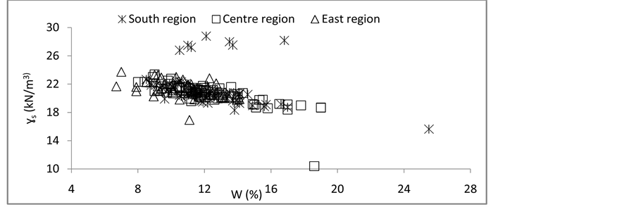
Figure 7. Relation between dry density and water content in the samples.
chanical behavior can be improved by adding sand [23] . [3] [26] recommend the use of lateritic gravels in the manufacture of road pavers because of their porous property. Several authors [1] [2] [3] [10] [23] [26] agree on the use of gravels in
Table 7. Different values of specific weight (γs in KN/m3) of samples.

Figure 8. Graph showing the evolution of dry grain density of samples.
Table 8. Different values of natural water content (W %)of samples.
road construction as the main body of the road. This recommendation is based on the results of the CBR and takes traffic into account. Thus, for values of 15 ≤ CBR ≤ 30 gravels are advised in layer form, for all classes of traffic. When the values of CBR increase (30 ≤ CBR ≤ 70), they are intended for the foundation layer, for traffics ranging from T1-T3. For a CBR value between 70 - 80, the materials are always used in layers of foundation with integration of the class of traffic T4. Gravels are exceptionally recommended as a base layer when CBR values are greater than 80, for traffics T1-T2 [1] . The results obtained in the characterization of lateritic soils of the road network in southern Cameroon are in agreement with those obtained [1] . Recent works also supports this approach [9] [10] .
6. Conclusion
The geotechnical characterization of the laterite materials of the South Cameroonian road network shows similar results in all the sampling sites. The granular classes spread from silt to gravel with the same tendency of granulometric
Table 9. AASHTO Soil classification of samples.
curves; the value of the 95% CBR is between 30 and 90; the water content at the optimum Proctor is less than 20%. Atterberg limits indicate that the Plasticity Index is low (<40%). The HRB classification shows that the soils at the origin of the materials are generally of the type A-2-7. These results are quite interesting in road construction and make it possible to advise the materials studied in the pavement body in particular in foundation layers for traffic classes ranging from T1 to T3. The present work also revealed the very limited influence of the nature of the parent rock on the mechanical properties of the gravels since the materials studied are derived possibly from very varied parent rocks. However, it is the process of the formation of lateritic materials by intense weathering under precise climatic conditions which can explain the great similarity of the mechanical behavior of the materials and consequently the results obtained. Furthermore, the results reveal that the south Cameroon road network is composed only by gravel soils in accordance with the different works conducted in the region.
Acknowledgements
The authors express their gratitude to: 1) National Civil Engineering Laboratory (LABOGENIE) staff for carrying out the geotechnical tests; 2) Professor P-D NDJIGUI of the University of Yaoundé 1 for his supervision and great support.
Cite this paper
Zame, P.Z., Assomo, P.S. and Onwualu, J.N. (2017) Assessment of Geotechnical Properties of Lateritic Gravels from South-Cameroon Road Network. International Journal of Geosciences, 8, 949-964. https://doi.org/10.4236/ijg.2017.88054
References
- 1. Sikali, F. and Djalal, M.E. (1987) Use of Laterites in Road Technology in Cameroon, Regional Seminar on Lateritic Soils. Workshops 1 and 3. ORSTOM, 277-288.
- 2. Bagarre (1990) Use of Lateritic Gravel in Road Technology. ISTED, 143 p.
- 3. Nwaiwu, O., Alkali, K. and Ahmed A. (2006) Properties of Ironstone Lateritic Gravels in Relation to Gravel Road Pavement Construction. Geotechnical and Geological Engineering, 24, 283-298. https://doi.org/10.1007/s10706-004-6374-7
- 4. Paige-Green, P., Pinard, M. and Netterberg, F. (2015) A Review of Specifications for Lateritic Materials for Law Volume Roads. Transportation Geotechnics, 5, 86-98. https://doi.org/10.1016/j.trgeo.2015.10.002
- 5. Kamtchueng, B.T., Onana, V.L., Fantong, W.Y., Ueda, A., Ntouala, R.F., Wongolo, M.H., Ndongo, G.B., Ze, A.N., Kamgang, V.K. and Ondoa, J.M. (2015) Geotechnical, Chemical and Mineralogical Evaluation of Lateritic Soils in Humid Tropical Area (Mfou Central Cameroon): Implications for Road Construction. International Journal of Geo-Engineering, 6, 1. https://doi.org/10.1186/s40703-014-0001-0
- 6. Netterberg, F. (2014) Review of Specifications for the Use of Laterite in Road Construction. AFCAP. Council for Scientific and Industrial Research, 10, 247-253.
- 7. Anonyme (1987) Recommendation for the Use of Natural Lateritic Gravel in Roadway Structure. Ministry of Equipment, Directorate General Studies and Standardization, Cameroon, 17 p.
- 8. Mahalinga-Iyer, U. and William, D.J. (1997) Properties and Performances of Lateritic Soil in Road Pavements. Engineering Geology, 46, 71-80. https://doi.org/10.1016/S0013-7952(96)00096-8
- 9. Onana, V.L., Ngo’o Ze, A., Medjo Eko, R., Ntouala, R.F.D., Nanga Bineli, M.T., Ngono Owoudou, B. and Ekodeck, G.E. (2017) Geological Identification, Geotechnical and Mechanical Characterization of Charnockites-Derived Lateritic Gravels from Southern Cameroon for Road Construction Purposes. Transportation Geotechnics, 10, 35-46. https://doi.org/10.1016/j.trgeo.2016.12.001
- 10. Nzabakurikiza, A., Onana, V.L., Ngo’o Ze, A., Ndzié Mvindi, A.T. and Ekodeck, G.E. (2017) Geological, Geotechnical, and Mechanical Characterization of Lateritic Gravels from Eastern Cameroon for Road Purposes Constructions Purposes. Bulletin of Engineering Geology and the Environment.
- 11. Bineli, E. (2009) Impact de la variabilité Climatique sur les Ressources en eau du Bassin du Nyong. Mém. DEA. FAC. Sc. UYI, 82 p.
- 12. Nzenti, J.P. (1987) Pétrogenèse des Migmatites de Yaoundé (Cameroun). Eléments pour un Modèle Géodynamique de la Chaine Panafricaine Nord équatoriale. Th. Doct. Univ. Nancy I, 147 p.
- 13. Ntouala, F. (2015) Altération Supergène des Chloritoschistes d’Ayos (Centre Cameroun). Ph. D. Thesis, Fac. Sci. Univ. Yaoundé I, 269 p.
- 14. Ekodeck, G.E. (2015) Geotechnical, Mechanical and Geological Characterization of Lateritic Gravels of Boumpial (Cameroon) Used in Road Construction. Journal of the Cameroon Academy of Sciences, 1, 45-54.
- 15. Kontchou, K.S.P. (2009) Estimation de la Perte de Graveleux Latéritiques Utilisés en Couche de Roulement: Application au Tron?on étoudi-Nkolbon Dans la Zone nord est de Yaoundé. Mem. DEA. FAC. Sc. UYI, 91 p.�
- 16. Bitom, D. (1998) Organisation et évolution d’une Couverture Ferralitique en Zone Tropicale Humide (Cameroun). Genèse et Transformation d’Ensemble Ferrugineux Induré Profond, Thèse Univ Poitiers, 164 p.
- 17. AFNOR. NF P 94-054, Sols (1991) Reconnaissance et Essais-Détermination de la Masse Volumique des Particules Solides des Sols-Méthode du Pycnomètre.
- 18. AFNOR. NF P 94-051, Sols (1993) Reconnaissance et Essais-Détermination des Limites d’Atterberg. Limite de Liquidité à la Coupelle-Limite, de Plasticité au Rouleau.
- 19. AFNOR. NF P 94-056, Sols (1996) Reconnaissance et Essais-Analyse Granulom étrique. Méthode par Tamisage à sec après Lavage.
- 20. AFNOR. NF P 94-078, Sols (1997) Reconnaissance et Essais-Indice CBR après Immersion. Indice CBR Immédiat. Indice Portant Immédiat. Mesure sur Echantillons Compacté dans le Moule CBR.
- 21. Maignien, R. (1966) Compte rendu des recherches sur les latérites. Recherches sur les ressources naturelles. UNESCO, Paris, 155 p.
- 22. Yongue-Fouateu, R. (1986) Contribution à l’étude Pétrologique de L’Altération et des Faciès de Cuirassement Ferrugineux des Gneiss Migmatiques de la Région de Yaoundé. Thèse 3éme Cycle, University Yaoundé, Yaoundé, 214 p.
- 23. Madu, M. (1975) Sand-Laterite Mixtures for Road Construction (A Laboratory Investigation). Nigerian Journal of Technology, 1, 20-32.
- 24. Ndjigui, P.D., Beauvais, A., Fadil-Djenabou, S. and Ambroisi, J.P. (2014) Origin and Evolution of Ngaye River Alluvial Sediments, Northern Cameroon: Geotechnical Constraints. Journal of African Earth Sciences, 100, 164-174. https://doi.org/10.1016/j.jafrearsci.2014.06.005
- 25. Elom, E.R. (2002) Les Produits d’altération des roches de la série d’Ayos: Propriétés Géotechniques et Qualité des Tuiles. Mem. DEA. FAC. Sc. UYI, 69 p.
- 26. Meissa, F. (1993) Identification et Caractérisation Mécaniques des Graveleux Latéritiques du Sénégal: Application au Domaine Routier, Thèse de l’INPI, 179 p.