International Journal of Geosciences
Vol. 3 No. 4 (2012) , Article ID: 22287 , 5 pages DOI:10.4236/ijg.2012.34066
Spatial Variability of Selected Soil Properties in Relation to Different Land Uses in Northern Kgalagadi (Matsheng), Botswana
Department of Environmental Sciences, University of Botswana, Gaborone, Botswana
Email: *totoloo@mopipi.ub.bw, mosweu@mopipi.ub.bw
Received April 20, 2011; revised May 22, 2011; accepted May 30, 2011
Keywords: Kgalagadi soils; land-use types; variation of soil properties
ABSTRACT
Spatial variability of selected soil attributes were investigated in the Kgalagadi region. Soil samples were collected along transects at Hukuntsi, Tshane, Lokgwabe and Lehututu at 50 m, 200 m, 500 m, 1000 m, 2000 m and 5000 m from water sources located in areas of different land use types. Sampling depth was 0 - 10 cm, 50 - 70 cm and 100 - 120 cm. Samples were analysed for pH, EC, SOC, and P. Soil pH and EC were relatively high around CGA Pans, while SOC and P were generally low in the whole study area. It was concluded that the assumptions that different land use types existed under various soil environments with different soil properties, and that different land use types influence soil characteristics in various ways in the study area were not true.
1. Introduction
The Kgalagadi ecological system covers about 80% of Botswana’s physical environment and most of it is in the western part of Botswana (sandveld) and extend to the eastern part of the country in some regions [1]. Kgalagadi is a plateau area uplifted following the break-up of Gondwanaland at least 65 million years ago [2]. The plateau edges were uplifted as the continent moved northwards [2]. Both fluvial and dune sediments are believed to have in-filled the uplifted basin with mainly sands interbedded with calcrete and silcrete [1,3]. Although there is a general impression that the Kgalagadi sandveld cannot sustain any significant land use production, recent studies [4] have demonstrated that within the Kgalagadi system there are a variety of land-use types that are influenced by spatial variability in soil properties. Against the commonly held view that the western part of Botswana is covered by uniform Kgalagadi sands that are practically infertile, it is now established that there are some soil and geomorphologic variations that sustain various land-use types [4]. This study examined selected soil properties (pH, electrical conductivity (EC), soil organic carbon (SOC) and Phosphorus (P) and established how they change within different land use types at various soil depths (0 - 10 cm, 50 - 70 cm and 100 - 120 cm). The study was based on the assumptions that different land-use types exist under various soil environments with different soil properties, and that different land use types influence soil characteristics in various ways in the study area.
2. The Study Area
The Matsheng area (size 44,000 km², about 1000 m above sea level) comprises four villages of Hukuntsi, Tshane, Lokgwabe and Lehututu, and a number of remote settlements. They are located on approximately 24˚S and 22˚E in the Kgalagadi north Sub-District (Figure 1).
Land in the area is generally used for grazing, small scale crop production, residential, other non-agricultural activities, and collection of veld products including wood resources. The area is among the driest in the country with annual precipitation ranging between 250 and 350 mm [5].
3. Materials and Methods
Transects were established in areas of different land use types in Hukuntsi, Tshane, Lokgwabe and Lehututu villages. Soil samples were collected along the transects at intervals of 50 m, 200 m, 500 m, 1000 m, 2000 m and 5000 m from water sources in the form of borehole or pan. The following land-use types were sampled: Communal grazing areas-pans (CGA Pans), Communal grazing areas-boreholes (CGA Bh), Tribal Grazing Land
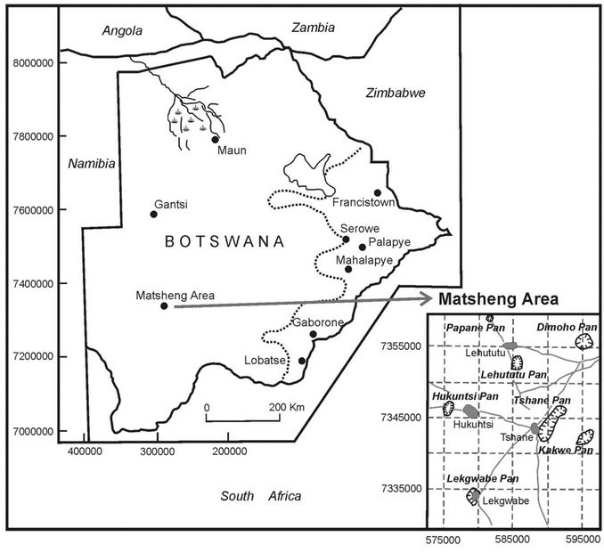
Figure 1. The location of Matsheng villages in Botswana.
Policy (TGLP) Farms and Wildlife Management Areas (WMAs). Soil samples were collected at 0 - 10 cm, 50 - 70 cm and 100 - 120 cm soil depth. It was decided to have shorter intervals close to the water point because of the likehood of rapid changes that had to be captured and then longer intervals away from the water sources. Soil samples were analysed for pH, EC, SOC, and P. Determination of EC and pH was conducted through methods proposed by [6], SOC was investigated using [7], and P was analysed using Olsen method [8].
4. Results and Discussion
Soils in WMAs, TGLP’s and CGA (Bh) were mainly acidic (pH < 7), while pH was relatively high around CGA Pans (PH > 8) (Figure 2). This was attributed to high concentration of salts in the pan environment. Generally, pH levels declined as the distance increased from water sources confirming that most Kgalagadi soils are acidic [3,4]. This trend was observed at different soil depths for the different land-use types. The greatest variability in pH was noted for CGA Pans, while the lowest variability was observed at the TGLP.
The EC of soils around pans was extremely high due to high concentrations of salts within the pan and the immediate surrounding areas (Figure 3). However, as the distance increased from the pan, the EC decreased markedly. This indicated that the influence of pan conditions on soils diminished with increase in the distance away from the pan environment.
SOC was generally low in the soils (<1%) (Figure 4). This implied that other soil parameters like Cation Exchange Capacity (CEC) that are normally influenced by SOC in soils may have generally been low [4]. The observation was in line with other soil studies elsewhere (e.g. [9]). Because of controlled grazing that was conducted in the TGLP farms and WMA, It was expected that the areas would exhibit relatively high SOC. However, clear trends in SOC that substantiate this did not emerge.
Low P levels were observed in the soils of the study area (Figure 5). Most studies conducted in the Kgalagadi region have indicated that the Kgalagadi sand is generally poor in terms P content [4]. Therefore, this observation provided further evidence of the low fertility status of soils existing in the Kgalagadi region.
5. Conclusion
This study was premised on the assumptions that 1) different land-use types existed under various soil environments with different soil properties, and 2) that different land use types influence soil characteristics in various ways. On the basis of the investigated soil characteristics,
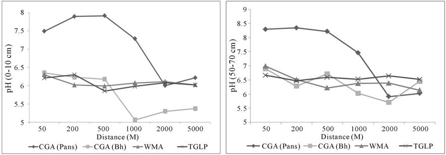
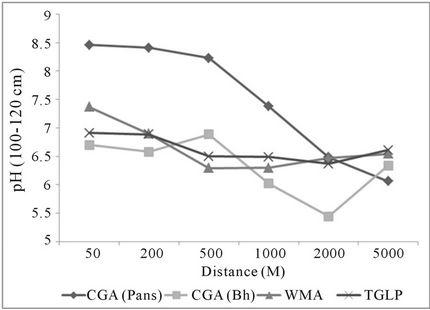
Figure 2. pH levels along transects established at different land types.
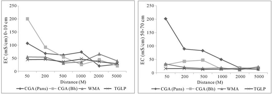
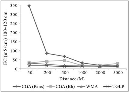
Figure 3. EC levels along transects established at different land types.
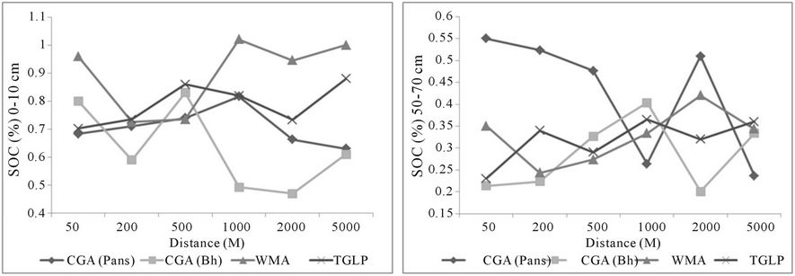
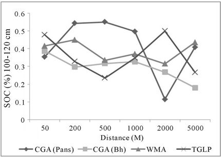
Figure 4. SOC along transects established at different land types.
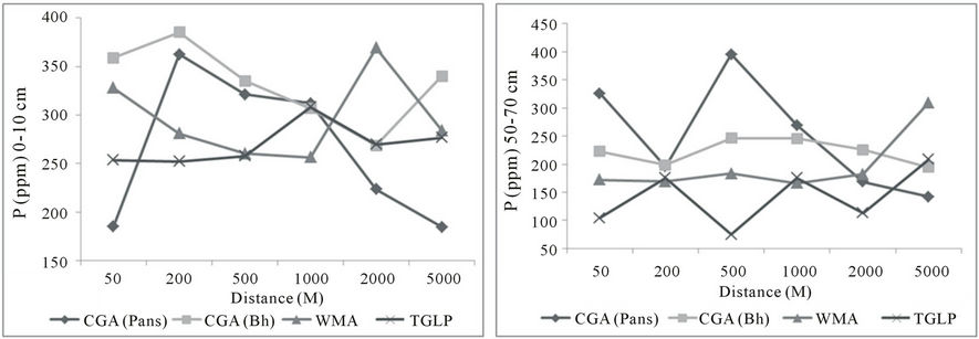
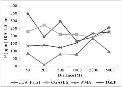
Figure 5. Phosphorus content along transects established at different land types.
it was concluded that both assumptions were false.
6. Acknowledgements
This study was part of the MAPOSDA project that was sponsored by the European Union and we appreciate their financial support.
REFERENCES
- O. Totolo and R. Chanda, “Environmental Change and Sustainability Issues in the Kalahari Region,” Journal of Arid Environments, Vol. 54, No. 2, 2003, pp. 257-259. doi:10.1006/jare.2002.1088
- D. S. G. Thomas and P. A. Shaw, “The Kalahari Environment,” Cambridge University Press, Cambridge, 1991.
- L. Wang, P. D’Odorico, S. Ringrose, S. Coetzee and S. A. Macko, “Biogechemistry of Kalahari Sands,” Journal of Arid Environments, Vol. 71, No. 3, 2007, pp. 259-279. doi:10.1016/j.jaridenv.2007.03.016
- R, Chanda, O. Totolo, N. Moleele, M. Setshogo and S. Mosweu, “Prospects for Subsistence Livelihood and Environmental Sustainability along the Kalahari Transect: The Case of Matsheng in Botswana’s Kalahari Rangelands,” Journal of Arid Environments, Vol. 54, No. 2, 2003, pp. 425-445. doi:10.1006/jare.2002.1100
- Y. P. R. Bhalotra, “Rainfall Maps of Botswana,” Department of Meteorological Services, Gaborone, 1985.
- L. P. Van Reeuwijk, “Procedures for Soil Analysis,” International Soil Reference and Information Centre Technical Paper No.1, 1993.
- A. Walkley and I. A. Black, “An Examination of the Degtjareff Method for Determining Organic Carbon in Soils: Effect of Variations in Digestion Conditions and of Inorganic Soil Constituents,” Soil Science, Vol. 63, 1934, pp. 251-263. doi:10.1097/00010694-194704000-00001
- S. R. Olsen, C. V. Cole, F. S. Watanabe and L. A. Dean, “Estimation of Available Phosphorus in Soils by Extraction with Sodium Bicarbonate,” United States Department of Agriculture, Circular No. 939, 1954.
- T. Mubyana, K. Martin, O. Totolo and M. Bonyongo, “Influence of Seasonal Flooding on Soil Total Nitrogen, Organic Phosphorus and Microbial Populations in the Okavango Delta, Botswana,” Journal of Arid Environments, Vol. 54, No. 2, 2003, pp. 359-369. doi:10.1006/jare.2002.1095
NOTES
*Corresponding author.