Open Journal of Modern Hydrology
Vol.05 No.01(2015), Article ID:53560,8 pages
10.4236/ojmh.2015.51001
Management Improvement of the Agmon Wetlands System (Hula Valley, Israel) Aimed at the Enhancement of Bird Populations and Kinneret Protection
M. Gophen
Migal-Scientific Reaserch Institute, Kiryat Shmone, Israel
Email: Gophen@Migal.org.il
Copyright © 2015 by author and Scientific Research Publishing Inc.
This work is licensed under the Creative Commons Attribution International License (CC BY).
http://creativecommons.org/licenses/by/4.0/


Received 4 January 2015; accepted 24 January 2015; accepted 27 January 2015
ABSTRACT
An ecological project is proposed for the system of Lake Agmon (Hula Valley, Israel). The project indicates a change of the original concept of the Hula Project construction. Practically Lake Agmon system was found to remove negligible amounts of Nitrogen and Phosphorus from the Lake Kinneret budget. Moreover, Lake Kinneret ecosystem has undergone limnological changes. The P limited Kinneret system is currently N limited. Therefore reduction of P and enhancement of N from the Hula Valley outflow might be beneficial to the Kinneret ecosystem. Currently, the TN concentration in the Agmon outflow is lower than in its inflow and vice versa for P. Consequently, this paper recommends conveying peat soil drained waters, the Agmon inflow, directly to Lake Kinneret instead of letting the waters flow through Lake Agmon. Nitrogen reduction in Lake Agmon is due to de-nitrification and sedimentation and P increase is due to degradation of aquatic vegetation. Additional benefit of this change is the predicted improvement of the new infrastructure for the activity of aquatic birds aimed at eco-tourism improvement.
Keywords:
Hula, Agmon, Kinneret, Nutrients, Management

1. Introduction
Until the early 1950s, the old Lake Hula and surrounding wetland (swampy) area (>8500 ha) included a unique composition of fauna and flora representing a handsome biodiversity [1] . Following the establishment of the state of Israel, the entire region was drained and an agricultural development scheme was implemented in it. The complete drainage of this lake-wetland eco-system was aimed at formation of an extensive region of highly productive agricultural land. Beginning in 1990, efforts were undertaken to restore a small (500 ha) portion of this region encompassing a relatively unproductive peat soil land. The creation of Lake Agmon (110 ha) and 400 ha around it was a land use conversion from agricultural to eco-touristic/safari utilization. Lake Agmon (area 110 ha; 0.4 m mean depth; volume 440 × 103 m3) is located between 33.7˚N and 35.4˚W within the northern part of the Syrian-African great rift valley (the Hula Valley). The present trophic status of Lake Agmon is mezo- eutrophic. The management concept of Lake Agmon is focused on the concern over nutrient loads released from the drained Hula Valley into downstream Lake Kinneret, which is the reason for the construction of Lake Agmon together with the development of high quality eco-touristic income source for the land owners. This operation, entitled “The Hula Project” [2] , was accomplished in 1997 and was accompanied by research and monitoring to determine the role of the lake in reducing nutrient loads. Extensive efforts have undertaken to understand the role of the peat soils as a nutrient source. To date, it appears that the lake outflow represents a relatively low source of TN and TP. Nevertheless, ecological modifications were developed in the Lake Kinneret ecosystem [3] , resulting in the need for re-consideration of the hydrological structure of the Agmon system combined with potential improvement of natural facilities for birds nesting and facilitating substrates. The aim of this paper is to evaluate hydrological and geochemical data of the Lake Agmon system aimed at renovated and beneficial structure to protect the quality of Lake Kinneret Water and enhance the water birds population density and nesting activity.
2. Background
2.1. Man Intervention in the Hula Valley Ecosystem
Until the late 1950s, the Hula Valley (altitude: 62.00 - 70.00 m above MSL) was covered by the shallow Lake Hula (1.5 m mean depth; 13 km2 water surface), and 3500 ha of swamps. The swampy area was completely water-covered in winter and partly covered in summer. The bottom sediments underneath the swamps vegetation were comprised of organic matter, nitrogen rich, under reductive conditions covered by water with low of oxygen content and probably anoxic during the night. This substrate was the origin of the Peat and after drainage- the peat organic soil. Northern to the swamps there was an area (3200 ha) where water table levels were high in winter time, making agricultural development impossible. During summer periods, when underground water level declined these 3200 ha, were successfully cultivated. During the 1950s, as a result of a government decision of the newly established (1948) State of Israel, the Hula wetland was dried and more than 6500 ha of natural wetland area, with a unique natural composition of fauna and flora of exceptional diversity, was turned over to agricultural use to serve as an income source for residents of the northern part of Israel [1] . During 40 years the dried area was successfully cultivated and agricultural products (mostly Cotton, Corn, Alfa-Alfa) were economically produced and nutrient flux into Lake Kinneret did not threaten its water quality [4] - [6] . Nevertheless, as a result of inappropriate management, drainage canals were blocked; irrigation methods were not suitable for optimal soil structure protection and water table declined. Consequently, soil structure of upper layers (0 - 0.5 m) was deteriorated and heavy dust storms occurred quite often in fall and spring by regional east wind (Sharkiya) resulted in subsidence of soil surface (averaged as 7 - 10 cm/year) and blocking of drainage canals occur. Due to the decline of water table level, lowering of soil moisture, longer time duration of uncovered soil by vegetation (agricultural crops or weeds) and inappropriate agricultural management, an outbreak of underground fire occurred frequently in summer time and a lot of water was needed for extinguishing which enhanced nutrient flux into Lake Kinneret. Rodent population outbreak caused severe damage to agricultural crops and stability of drainage canal banks. 10% of the total dried area, in the middle part of the valley (at lowest altitude), went through processes causing extreme soil deterioration and subsidence which made it impossible to maintain a beneficial cropping and these 500 ha were neglected and not cultivated and the threat on Kinneret water quality was enhanced.
2.2. Hula Project (HP) [7] [8]
As a result of soil quality deterioration and the threat on the Kinneret water quality, a reclamation project was proposed and implemented (1990-1997) [2] . The project was aimed at the reduction of nutrient fluxes from Hula soil while continuing the economical utilization of the land by partial modification of land utilization from agriculture to ecotourism. The concept of the new land use was based on manmade structural changes of the system by incorporation of natural components (fauna and flora). The reclamation proposal of “The Hula Project”, included several elements based on the concept of increasing the level of soil moisture by elevating the water table, changing the irrigation system and reconstruction of the hydrological (drainage) system of the valley (Figure 1) [2] . This included 90 km of drainage canals, used both for water supply for establishing a higher water table, and draining excess waters; creating the shallow Lake Agmon (0.4 average depth; 110 ha area) to be operated as a drainage basin for the valley and eco-touristic wetland. Water effluents from Lake Agmon are removed by pumping system and free flow in open canals, from the Kinneret catchment. The function of the lake is not only being part of the drainage system but also to serve as an eco-touristic attraction, therefore its water quality, landscape and the composition and density of its flora and fauna affect its quality. A plastic sheet (4 mm thickness) was placed vertically (0 - 4.5 m) along 2.8 km, across the western part of the valley, to prevent underground infiltrated flows down stream to Lake Kinneret (Figure 1). The ecology of Lake Agmon was studied during 1994-2002 [2] [4] . Comprehensive information about Lake Agmon and around it is presented here with an attempt to emphasis the need to combine economical, limnological and ecological aspects in one project of constructed wetlands. The Agmon wetlands ecosystem is an example of management design and constructed infrastructure as a package deal between three social sectors: 1) the land owners (farmers) that the Hula Valley area is an income resource for them; 2) Water managers which are responsible for the limnological protection of Lake Kinneret for drinking water supply; 3) the “greens”?nature ecologists. Protection of the Kinneret water quality is essential because more than 50% of its external load mass of N and P forms originate from the Hula Valley zone.
3. Methods
The data on nutrients, hydrology, vegetation and birds within the Hula Project were compiled from the annual (1994-2007) reports of “The Hula Project” [9] [10] (1994-2013) submitted to Migal-Scientific Research Institute in the Gallilee, The Israeli Water Authority, and Jewish National Fund (KKL). Methods of sampling stations, frequency of sampling, chemical analysis techniques, birds monitoring, hydrological measurements and survey of aquatic plant distribution are given in those reports. The recent changes of the limnological features of Lake Kinneret are given in Gophen [3] [11] [12] and Gophen et al. [13] . The only presented Water Budgets (Tables 1-3) are those of the years of 2005 and 2006 because an automatic system was introduced later and calibrations were not yet completed.
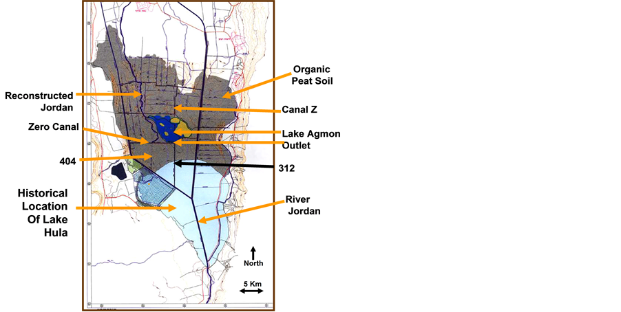
Figure 1. Map of Hula Valley and Hula Project. Indication of the old Lake Hula Location is given.
Tables 1-3. Annual balance of the Agmon system in mcm/y (106 m3/year) in 2005 and 2006.

Table 1. Inflow mcm/y (106 m3/year).
Table 2. Outflow mcm/y (106 m3/year).
Table 3. Comprehensive annual balance (mcm/y (106 m3/year)); WL-water level change.
4. Results
4.1. Temporal Nutrients Fluxes
Temporal dynamics of nutrient fluxes from the peat soil located northern and eastern to Lake Agmon are presented in Figure 2. During summer months (6 - 10) when the natural moisture is low (no rainfall, Figure 3), soluble and transportable substances having therefore shorter retention time such as TN (mostly TDN, NO3∙NH4) and Total Dissolved Substances (like Gypsum) are less intensively migrate. As a result, their concentration in drained water is low in summer and consequently water Electric Conductivity (data not given) is low. During winter months (11 - 12 and 1 - 5) these movable compounds having short retention time are intensively dissolved and transported and their concentration (and EC) is therefore high in the drained waters. From February the rain is declining resulted in decreasing of the flux of these compounds (Figure 2). The Peat soil in the Hula Valley is characterized by high content of Phosphorus compounds absorption to organic matters. During summer months (11 - 12 and 1 - 5) peat soil moisture decline and the organic matter is degraded. The previously absorbed P compounds become transportable having short residence time. The infiltrated flushes of irrigated waters carry and transport those P substances. Therefore, the concentration of P and mostly Total Dissolved fractions (TDP, Figure 2) increase in summer and decrease later when irrigation stops, in fall season clearly represent their short residence time when soil moisture decline. During winter time the peat soil moisture is high and P is less transportable and its flux is therefore minimal. Residence time of Nitrogen in the Hula Peat soil is shorter in winter and longer in summer and that of Phosphorus is the opposite, longer in winter and shorter in summer.

Figure 2. Trend of changes (lowess (0.8); Stata SE 9.0) of monthly mean con- centrations (ppm) of Total Phosphorus (TP), Total Dissolved Phosphorus (TDP) (lower panel), Total Nitrogen (TN), and Total Dissolved Solids (TDS) (upper panel) in the peat drainage waters of Canal Z (Agmon inlet); biweekly samples 1994-2006.

Figure 3. Monthly averages (1939-2003) of rainfall, measured in four stations in the Hula Valley: Kfar Blum, Kfar Giladi, Dan and Dafna.
4.2. Lake Agmon Water Balance
In order to evaluate the contribution of the Hula Valley region, particularly Hula Project section to the Kinneret, the hydrological balance of lake Agmon is essential (Tables 1-3). The data given in Table 1 and Table 2 indicate higher difference of Canal z and Jordan inflows which are the principle sources of Lake Agmon and consequently the outflows, between 2005 and 2006. Nevertheless evaporation, rainfall are closely related. The complete balance is presented in Table 3 and indicates higher (×4.7) outlet factor of the comprehensive balance in 2006. It is therefore likely that water residence time was 21 and 14 days in 2005 and 2006 respectively. The 7 days shorter residence time in 2006 was the result of management regime that was aimed at minimal changes of WL (Table 3). Infiltration rates (in and out) were higher in 2006 also resulted by management operation.
4.3. Nutrient Dynamics
The origin of significant portion of the Kinneret external N and P loads is in the Hula Valley of which 2% - 10% from the Hula Project zone (Tables 4-6). The seasonal pattern of nutrient fluxes from the peat soil was defined. The low contribution of the Hula valley and particularly the Hula Project region, as measured in surface waters was documented. The peat soils forms a complicated system of preferential pathways and the information about underground discharges and chemical qualities indicates an underground migration of nutrients from north to south. The Lake Kinneret Nitrogen load is mostly affected by external sources. Whilst, internal sources and atmospheric deposition significantly affect Kinneret P loads. Results in Table 4 indicates higher outflow of P
Table 4. Multi-annual (1994-2005) averages of TP, TDP, TN, TDN, NH4 and NO3 concentrations (ppm) in Agmon outflow and inflow (Canal Z) waters (SD < 30%).
Table 5. Annual loads (tons/year) of nutrients fluxes from Canal Z into Agmon and through Agmon outlet.
Table 6. Annual Balance of Agmon nutrients (TP, TDP, TN, TDN, NH4 and NO3 (tons/year) during 2005. − = addition/surplus; + = removal; balance = input minus output.
forms than inflows, i.e. additional contribution from internal sources in Lake Agmon. All N forms (TN, TDN, NO3∙NH4) represent the opposite, i.e. nitrogen removal (Table 5 and Table 6). It is suggested that additional contribution of P is due to aquatic vegetation degradation. N removal is due to both de-nitrification and sedimentation. The quantitative loads (tons/year) of Lake Agmon inflow and outflow of nutrients are given in Table 5. Removal of Lake Agmon outflows will remove 1.2 and 27.3 tons of TP and TN respectively. It is also clear that most of the N and P loads are due to soluble forms.
4.4. Birds Distribution and Species Diversity [14]
The Hula Valley is a critical migratory stopover and wintering site for birds along the Eastern Eurasian-African Flyway. Since the creation of the new wetland in 1994 (Lake Agamon), water birds enhanced the use of this region as a wintering station. Water level in Lake Agmon and in the underground as well as the land-use policy is under man control, and bird distribution has second level priority. Aquatic birds, population were monitored during 2005-2010, with an emphasis on the most common Grey Crane. The seasonal species diversity of Aquatic bird diversifies significantly between seasons but was stable annually. Species diversity was positively correlated with water level in Lake Agmon during winter and autumn and negatively correlated during the summer. Cranes distribution in the Hula Valley have increased dramatically from less than 100 in early 1990s to 35,000 in 2014. Cranes responded negatively to water level in Lake Agmon under high regime.
Crane wintering behaviour patterns in relation to supplemental feedings followed The Hula Valley is highly prefer by migratory birds. More than 300 species of birds, including 21 globally threatened and 16 state threatened.
An estimation of 500 million bird specimen of migrates through the Rift Valley in autumn and spring. Agmon system is managed primarily for agriculture and tourism usage. Nevertheless, ecological considerations became recently a significant parameter included within the region management design. Hydrological management is a key factor for maintaining optimal habitat for water-birds. Appropriate management of the wetland ecosystem aimed at optimization of the water-birds habitat will support the protection of rare species and enhancement of the site attractiveness towards eco-tourism contributing income resources for the local land owners.
4.5. Aquatic and Semi-Aquatic Birds
A total of 70 aquatic-bird species were documented. Common cranes, common teal, mallard and common coot were the most abundant species, all of which are wintering species except for the mallard that has a small resident population.
Species diversity of aquatic birds and water levels were highest in spring and lowest in summer-autumn. Differences between seasons were significant for water-bird diversity (p < 0.000) and species richness (p < 0.005). Total species and specimen abundance of aquatic birds indicated the highest values in winter. Monitored averages of species were: spring 143, summer 44, autumn 26, and winter 234. The most common (maximum monthly) number of species of aquatic birds in Lake Agmon and around it indicated, among others, 364 Cormorants, 110 Cattle Egrets, 107 Little Egrets, 184 Large Waders, 8135 Ducks (Anas spp.) 1792 Grazers, 327 Small Waders, and 20,000 - 50,000 of the Semi-Aquatic Crane birds (Grus grus). Feeding habits of the 70 species of the observed water-birds is distributes as follows: 46% Benthivores, 31% Piscivores, 11% Omnivores, 8% Herbivores and 4% Diving Herbivores. It should be considered that Cranes are terrestrial birds but assembled during sunset for sleeping stay in-water at the shallow part of southern region of Lake Agmon. The “aquatic” type of night stay is giving these birds prey (Jackel, Wolf, Mangus, and Fox) protection.
Water Budget of Lake Agmon (Tables 1-4)
Results that are presented in Tables 1-4 indicate significant quantitative differences of Canal Z inflow and there- fore in total gains between 2005 and 2006.
5. Discussion
The Hula Project rational was aimed at three targets: 1) Nutrient removal from the Lake Kinneret loads; 2) To improve agricultural development in the Hula Valley; 3) To establish reasonable income for the Land owners of the most problematic part of the valley comprised of 500 ha of low soil quality; 4) To partly renovate the natural habitat of the old Hula swamps. The HP infrastructure was accomplished in 1997 and the newly created Lake Agmon was completed and filled with peat drained and fresh Jordan waters. Immediately after the accomplishment of the HP a remarkable rehabilitation of avi-fauna and partly vegetation were documented. The eco-touris- tic zone became a widely known attractive element in the state of Israel mostly due to the Crane observation. On the other hand information about nutrients dynamic and the Hydrology of Lake Agmon system and particulate matter sedimentation making water depth shallower together with chemical investigation of the underground waters indicated two un-expected processes: 1) Nutrient migration from the northern to the southern parts of the valley through sub-surface preferential water pathways crossing the plastic barrier underneath and/or aside [12] [15] . Quantification of N and P nutrient loads removed by the Agmon system was found to be negligible: 1 - 2 tons TP and 25 - 30 tons TN annually [16] . The annual influx of external nutrients through river Jordan into Lake Kinneret is >1000 tons TN and >60 tons TP. Independently ecological conditions in Lake Kinneret were modified. As a result of Epilimnetic Nitrogen decline and a slight increase of TP, the Kinneret Epilimnion was shifted from P limited to N limited ecosystem [3] [11] - [13] . Those conditions initiated the need for reconsideration of Lake Agmon management. The aim of this paper is to define an improvement of management operation of the Agmon system. The principles of the modified concept are:
Enhancement of N and reduction P supply from Lake Agmon to Lake Kinneret accompanied by improvement of birds habitat for nesting and feeding strengthening the touristic property of the system. The newly proposed operation includes direct flow connection through existed canal from the peat soil to Lake Kinneret. Such a system will supply peat soil drained waters containing higher than the Agmon outflow Nitrogen and lower TP concentrations (Canal Z, Table 4 and Table 5). The inlet water quantity will be reduced and the Agmon depth become shallower for the benefit of aquatic birds activity. The major water supply to Lake Agmon will be the Jordan and infiltration. One of the predicted risks to the Agmon waters is therefore salinization. This can be compensated by provisional short time diversion of Canal Z waters into Lake Agmon. The renovated Agmon wetlands habitat will be shifted from shallow lake to a swampy type better accommodated for birds populating assemblages. The proposed change of the Hydrological structure will elongate the residence time of this body of water and probably enriched the aquatic flora (emergent stands of Typha) and fauna species diversity and biomass.
6. Summary
A new ecological project is proposed for Lake Agmon (Hula Valley, Israel) system as part of the original concept of the Hula Project construction. Practically, Lake Agmon system removes negligible amounts of TN and TP from the Lake Kinneret budget. The Lake Kinneret ecosystem has undergone ecological changes. The P limited Kinneret system is currently N limited. Reduction of P and enhancement of N from the Hula Valley outflow may be beneficial for Lake Kinneret. As a result of de-nitrification and sedimentation and decomposition of aquatic vegetation, the TN concentration in the Agmon outflow is lower than in its inflow and the opposite for P content. Consequently, it is recommended to convey peat soil drainage, directly to Lake Kinneret and not flow through Lake Agmon as currently. Agmon WL will decline and habitat improvement for aquatic birds is predicted accompanied by eco-tourism benefit.
References
- Dimentman, Ch., Bromely, H.J. and Por, F.D. (1992) Lake Hula: Reconstruction of Fauna and Hydrobiology of a Lost Lake. The Israeli Academy of Sciences and Humanities, Jerusalem, 170 p.
- Gophen, M. (2000) The Hula Project: N and P Dynamics in Lake Agmon and Pollutants Removal from the Kinneret Inputs. Water Science and Technology, 42, 117-122.
- Gophen, M. (1999) Prediction of an N2-Fixing Cyanobacteria Bloom in Lake Kinneret (Israel) Based on N and P Balance. Verhandlungen des Internationalen Verein Limnologie, 27, 1239-1242.
- Gophen, M. (2000) Nutrient and Plant Dynamics in Lake Agmon Wetlands (Hula Valley, Israel): A Review with Emphasis on Typha Domingensis (1994-1999). Hydrobiologia, 1-12.
- Gophen, M. (2008) Long Term (1970-2001) Eco-Hydrological Processes in Lak Kinneret and Its Watershed. In: Zereini, H., Ed., Climatic Changes and Water Resources in the Middle East and in North Africa, Invited Chapter, Springer, Berlin, 373-402.
- Paine, R. and Gophen, M. 22011/2012. Mires and Peat, The Hula Peatland: Past, Present and Future. Volume 9 Special volume. Compiled by Richard Paine with Guest Editor Moshew Gophen, Forward by R/ Paine and M. Gophen.
- Gophen, M. (2004) Water Utilization in a Semi-Arid Zone, the Hula Valley (Israel): Pollutant Removal, Agriculture and Ecotourism Management. In: Zreiny, F. and Hotzl, H., Eds., Water in the Middle East and in North Africa: Resources, Protection, and management, Springer, Berlin, 207-226.
- Gophen, M. (2004) Ecohydrological Management of Lake Kinneret: A Case Study. Ecohydrology and Hydrobiology, 4, 397-408.
- Gophen M., Ed. (1995-2006) Hula Project Annual Reports. Migal, Water Authority, and Jewish National Fund (KKL). (In Hebrew)
- Barnea, I., Ed. (2007-2013) Hula Project Annual Reports. Migal, Water Authority, and Jewish National Fund (KKL). (In Hebrew)
- Gophen, M. (2011) The Cladoceran Trophic Status in the Nitrogen Limited Ecosystem of Lake Kinneret (Israel). Journal of Environmental Biology, 32.
- Gophen, M. (2014) The Impact of Water Level Decline on Water Quality in the Epilimnion of Lake Kinneret (Israel): Perennial Perspectives. Open Journal of Ecology, 4, 892-906.
- Gophen, M., Smith, V.H., Nishri, A. and Threlkeld, S.T. (1999) Nitrogen Deficiency, Phosphorus Sufficiency, and the Invasion of Lake Kinneret, Israel, by N2-fixing Cyanobacterium Aphanizomenon Ovalisporum. Aquatic Sciences, 1, 1- 14.
- Labinger, Z. and Alon, D. (2006) Birds Chapter. In: Gophen, M., Ed., Hula Project Annual Report, 44-74.
- Gophen, M., Meron, M., Orlov-Levin, V. and Tsipris, Y. (2014) Seasonal and Spatial Distribution of N & P Substances in the Hula Valley (Israel) Subterranean. Open Journal of Modern Hydrology, 4, 121-131. http://dx.doi.org./10.4236/ojmh.2014.44012
- Gophen, M., Tsipris, Y., Meron, M. and Bar-Ilan, I. (2003) The Management of Lake Agmon Wetlands (Hula Valley, Israel), Shallow Lake Conference, Lake Balaton, Hungary, June 2002. Hydrobiologia, 506, 803-809.