Open Journal of Modern Hydrology
Vol.04 No.04(2014), Article ID:49813,10 pages
10.4236/ojmh.2014.44010
Land-Use, Albedo and Air Temperature Changes in the Hula Valley (Israel) during 1946-2008
Moshe Gophen
Migal Galilee Scientific Research Institute, Kiryat Shmone, Israel
Email: Gophen@Migal.org.il
Copyright © 2014 by author and Scientific Research Publishing Inc.
This work is licensed under the Creative Commons Attribution International License (CC BY).
http://creativecommons.org/licenses/by/4.0/

![]()

Received 16 July 2014; revised 15 August 2014; accepted 15 September 2014
ABSTRACT
Long-Term (1946-2008) record of 35,580 measurements of daily mean air temperatures in three meteorological stations (Dan, Dafna, Kfar Blum) in the
Keywords:
Hula, Albedo, Land-Use, Regional Climate

1. Introduction
Until 1958 the Hula Valley was covered by the shallow Lake Hula ( 1.5 m mean depth; 1300 ha water surface), and 4500 ha of which part was permanently and part was seasonally covered by water and vegetation [1] . During 1950-1957 old
1.1. Hydrology
The Kinneret drainage basin area is 273 × 103 ha, including Hula Valley (20 × 103 ha, altitude range of 60 - 180 masl). The altitude of the northern end of the drainage basin is 2814 masl located 61 km from the south end of the basin at the northern end of Lake Kinneret (WL of 210 mbsl) creating a mean slope of 5%. Three major rivers—Hatzbani (130 × 106 m3/year), Banyas (app. 115 × 106 m3/year), and Dan (app. 260 × 106 m3/year) (see Photos 1-2; Map) flow from north to south crossing the Hula Valley. These rivers joint into one river Jordan (app. 500 × 106 m3/year) which until 1957 crossed the swampy area through three major arms (tributaries) flowing into old Lake Hula. From the Hula Valley (61 masl) River Jordan flows along 15 km south into Lake Kinneret (210 mbsl). The water level of old Lake Hula fluctuates between 1.0 - 2.0 m, inundating the adjacent swamps and land in winter.
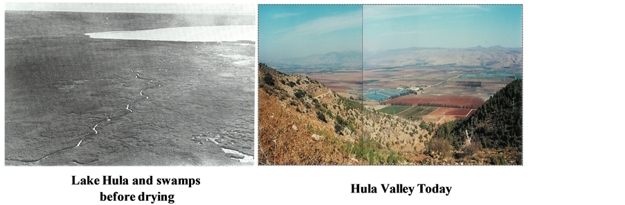
Photo 1
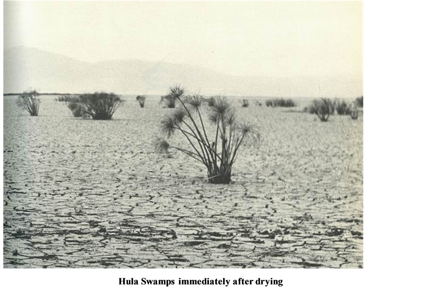
Photo 2
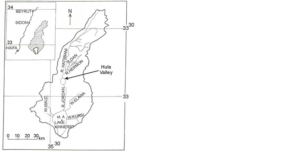
Map of the Kinneret drainage basin
1.2. The Hula Project (HP)
During 1950-1957, the old Lake Hula and swampy areas around were drained and 5900 ha of natural ecosystem, including a unique natural composition of fauna and flora, was turned over to agricultural use to serve as an income source for residents in the northern part of Israel. 40 years later the drained area was successfully cultivated not without difficulties. One of those difficulties was bare peat soil which was a source of heavy dust storms. Nevertheless, nutrient flux from the
As a result of natural modifications and the above description of anthropogenic intervention, the ecological conditions in the Kinneret Ecosystem had undergone several changes: air and lake water temperatures were lowered until the mid 1980’s and increased later [2] . The air temperature increase together with WL decline caused enhancement of heat capacity of Lake Kinneret Epilimnion [3] . Regional precipitation was declined during 1970-2010 despite exceptional heavy rain gauge more or less every 10 years [8] . This paper is an attempt aimed at the potential correlation between air temperature and human activity in the Hula Valley through the key factor of Albedo Factor [4] - [7] .
2. Material and Methods
Temperature data were collected from the Annual Reports of the Palestine\Israel Meteorological Service (1946-2008) [8] . Air temperature data (35,580 daily measurements) recorded in three stations in the Hula Valley, Dafna, Dan and Kfar Blum located in the vicinity of the swampy region were statistically evaluated. Daily mean temperature was calculated as: (Daily Maximum + Daily Minimum)/2. The following statistical analyses were done.
STATA 9.1 (2005) [9] :
LOWESS (Tension = 80), Fractional Polynomial and Linear Prediction; ANOVA Test (p < 0.05), by Statview 5.0 [10] , (SAS Institute Inc.) Power Mac Version.
The information about the Hula Valley, Hula Project, land-use and anthropogenic activities was taken from Hula Project Annual Reports [11] and historical maps collection, Tel Hai College Library.
3. Results
Land-use History in the Hula Valley is summarized in Table 1.
Berman [12] , Stanhill and Neumann [13] and Serruya [14] , published information on Solar Radiation in Lake Kinneret and daily net ranged between 24.3 × 10⁶ J·m−2d−1 (June-July) and 1.8 × 10⁶ J·m−2d−1 (December) and annually averaged for the Kinneret region as 15.1 × 10⁶ J·m−2d−1. It is suggested that anthropogenic changes in the Hula Valley affected air temperatures through Albedo Effect. Therefore, evaluation of Albedo potential impact was investigated. What is Albedo?
If A = Total Incident Energy = Radiation from sun and sky, and B = Energy Reflected from Surface, Then, Albedo is indicated as N = Net surface Radiation = A – B = Albedo in %.
Air temperature changes in the Hula Valley are presented in Figures 1-7 (Fractional Polynomial analyses) and Table 2. The curve in Figure 1 (LOWESS; Tension = 80) represents the entire period 1946-2008, where all measurements are incorporated and indicating a decline from 1946 until the 1980’s and increase later. Statistical indicative significance of the conclusions about periodical changes done by Fractional Polynomial analysis with 95% confidence level is given in Figure 2. The entire record is divided into shorter segments (Figures 3-7) for detailed timing serial changes (Factorial Polynomial). Figure 3 (1946-1958) presents a clear daily temperature decline, the decreasing trend continued during 1959-1970 (Figure 4), and lasted onwards during 1971-1976 (Figure 5). Temperature elevation began in the mid 1980’s (Figure 6, 1983-2000) and also shown in the period 1995-2000 (Figure 7). ANOVA (p < 0.05) test (Figure 8) summarized comparison between air temperature fluctuations and periodical changes of land-use changes (Table 1). Air temperatures after the drainage of Lake Hula and the wetlands (1959-1990) were significantly lower than earlier and after HP implementation (1991-2008) increased. The complete record of annual average fluctuations is given in Figure 9. The periodical trends are indicated.
The results presented in Table 2 indicate the following fluctuations: From 1946 to 1990 mean air temperature declined by 1.3˚C (20.2˚C to 18.9˚C). Before Hula drainage air temperature was probably higher than during the post drainage period. Nevertheless, later than 1990 (HP implementation was carried out from the early 1990’s) air temperature was elevated by 0.9˚C until 2008. In other words, Hula drainage was followed by decline and HP implementation by increase of air temperature. Results presented in Figure 8 indicate significant air temperature decline after 1958 (p = 0.0133) which also significantly continued until 1990 (p = 0.0023). The difference between 1959-1982 and 1983-1990 periods was insignificant. Nevertheless the temperature elevation after 1990 is significant (p = 0.0261).

Table 1. Land use in 10 2 ha (%) in the Hula Valley during 1949-2010: 1952-1958—Hula drainage; 1990-1994—Hula Project Implementation. Information Source: The Historical Maps Collection; Tel Hai Academic College (Margalit, A. and Israeli, E.).
Table 2. Periodical (see Figure 8) averages of annual means of air temperature in the Hula Valley (three station means).

Figure 1. LOWESS (Tension = 80) curve of annual averages of air temperature daily means during 1946-2008.

Figure 2. Fractional polynomial curve of annual averages of daily means of air temperatures during 1946-2008.
![]()
Figure 3. Fractional polynomial curve of annual averages of daily means of air temperatures during 1946-1958.
![]()
Figure 4. Fractional polynomial curve of annual averages of daily means of air temperatures during 1959-1970.
4. Discussion
Hall [7] , Hall and Qu [9] and Levis et al. [8] documented the impact of Albedo Feedback on air temperature as scaled for global and continents dimensions. Stanhill [15] , and Stanhill and Neumann [13] , documented air temperature decline in the Kinneret region but related it to a decline of solar radiation. Changes of Albedo values as scaled globally or regionally were discussed widely in [6] [8] [9] , and [16] - [18] [22] . It is suggested that a change of the Albedo value resulted in by the
Albedo is the measure of the reflective of the earth’s surface. Water is much more absorbent and less reflective than soil and bare soil is more reflective and less absorbent than grass covered land. When Albedo of certain substrate is increasing heat balance becomes warmer and vice versa [19] - [21] . Consequently, if Albedo increases air temperature above declines. In general, when global light reflection is increasing the mean planet temperature declines. If we take into account the regional scaled case of the Kinneret drainage basin, it is suggested that when the Hula Valley was drained and water cover portion diminished from about 100% (before 1957) to 15.5% (after 1957) Albedo was elevated and air temperature declined. During 1958-1986 the
![]()
Figure 5. Fractional polynomial curve of annual averages of daily means of air temperatures during 1971-1976.
![]()
Figure 6. Fractional polynomial curve of annual averages of daily means of air temperatures during 1983-2000.
![]()
Figure 7. Fractional polynomial curve of annual averages of daily means of air temperatures during 1995-2008.
![]()
Figure 8. Results of ANOVA (p < 0.05) test of comparative periodical (1-4) analysis: 1 = 1946-1958; 2 = 1959-1982; 3 = 1983-1990; 4 = 1991-2008.
![]()
Figure 9. Annual averages of daily mean air temperature (lower panel) and deviation (˚C) from the multiannual average (19.6˚C) (upper panel) during 1946-2008; Trends of change are arrowed.
accompanied by air temperature increase. The accomplishment of the Hula Project supplied energetic load resulted by declined Albedo which was transferred to the Evapo-Transpiration latent heat flux followed probably by elevation of air temperature above. The phenomena of higher air temperature above grass land and/or forest in comparison with bare soil surface was widely documented [17] [22] . As much as light reflection from surface (grass land, water covered, forest etc.) is increasing, its temperature is declining and consequently air temperature above it. The history of agro-meteorological events of the Hula Valley includes the following succession: the valley was mostly covered by water and aquatic plants with low value of Albedo. Drainage accomplishment (1957) enhanced reflection (Albedo) and accompanied by decline of air temperature. Aquatic-swampy land use was replaced by agricultural crops with long time uncovered soil surface initiating higher values of Albedo resulted in a decline of air temperature. It was changed by the Hula Project implementation when land use policy was renovated towards longer time of grass (green) cover together with partial water (Agmon Wetlands) cover supporting a decline of Albedo values and elevation of air temperatures. The impact of Hula Project can is indicates as follows: lowering of Albedo values supplied energetic load which was transferred to the latent flux of heat through Evapo-transpiration and the air temperature in air layers covering these land became warmer. During partial bare soil surface after drainage operation and before Hula Project achievement Albedo was elevated and air temperature declined. The dark colored Peat soil in the
5. Conclusion
Long-term record (1946-2008) of daily means of air temperature indicates periodical decline after Hula drainage and increase later when land use is improved. These climatological fluctuations are conclusively related to changes of Albedo levels.
References
- Dimentman, C., Bromley, H.J. and Por, F.D. (1999) Lake Hula. Israeli Academy of Sciences and Humanities, Jerusalem, 170 p.
- Gophen, M. (2008) Long Term (1970-2001) Eco-Hydrological Processes in Lake Kinneret and Its Watershed. In: Zereini, H., Ed., Climatic Changes and Water Resources in the Middle East and in North Africa, Invited Chapter, Springer, Berlin, 373-402.
- Rimmer, A., Gal, G., Opher, T., Lechinsky, Y. and Yacobi, Y.Z. (2011) Mechanisms of Long-Term Variations of the Thermal Structure in a Warm Lake. Limnology and Oceanography, 56, 974-988. http://dx.doi.org/10.4319/lo.2011.56.3.0974
- Otterman, J. (1974) Baring High Albedo Soils by Overgrazing: A Hypothesized Desertification Mechanism. Science, 186, 531-553. http://dx.doi.org/10.1126/science.186.4163.531
- Hall, A. (2004) The Role of Surface Albedo Feedback in Climate. Journal of Climate, 17, 1550-1568. http://dx.doi.org/10.1175/1520-0442(2004)017<1550:TROSAF>2.0.CO;2
- Levis, S., Bonan, G.B. and Lawrence, P.J. (2007) Present-Day Springtime High-Latitude Surface Albedo as a Predictor of Simulated Climate Sensitivity. Geophysical Research Letters, 34, 12-14.
- Hall, A. and Qu, X. (2006) Using the Current Seasonal Cycle to Constrain Snow Albedo Feedback in Future Climate Change. Geophysical Research Letters, 33. http://dx.doi.org/10.1029/2005GL025127
- Israel\Palestine (1946-2008) Meteorological Service Annual Reports.
- STATA 9.1 (2005) Statistic Data Analysis. Stata Corp., College Station, Texas. Single-User Stata for Macintosh Perpetual license: S.No. 8490533756, Tel Hai.
- Statview 5.0 (1998) Power Mac Version. SAS Institute Inc.
- Gophen, M., Ed. (1996-2006) Hula Project Annual Reports. KKL and Water Authority and Migal Library.
- Berman, T. (1976) Light Penetrance in Lake Kinneret. Hydrobiologia, 49, 41-48. http://dx.doi.org/10.1007/BF00016166
- Stanhill, G. and Neumann, J. (1978) Book Chapter: The General Meteorological Background. In: Serruya, C., Ed., Lake Kinneret, Monographiae Biologicae, Junk Publishers, 49-58.
- Serruya, S. (1978) Book Chapter: Solar Radiation. In: Serruya, C., Ed., Lake Kinneret, Monographiae Biologicae, Junk Publishers, 59-92.
- Stanhill, G. (1992) Lake Kinneret Water Cooling—Does It due to Solar Radiation Decline? The Biosphere, 22, 8-9. (In Hebrew)
- Li, Z.Q. and Garand, L. (1994) Estimation of Surface Albedo from Space: A Parameterization for Global Application. Journal of Geophysical Research: Atmospheres, 99, 8335-8350.
- Ben-Gai, T., Bitan, A., Manes, A., Alpert, P. and Israeli, A. (1998) Aircraft Measurements of Surface Albedo in Relation to Climate Changes in Southern Israel. Theoretical and Applied Climatology, 61, 207-215.
- Otterman, J. and Tucker, C.J. (1985) Satellite Measurements of Surface Albedo and Temperatures in Semi-Desert. Journal of Climate and Applied Meteorology, 24, 228-235. http://dx.doi.org/10.1175/1520-0450(1985)024<0228:SMOSAA>2.0.CO;2
- Rotenberg, E. and Yakir, D. (2011) Distinct Patterns of Changes in Surface Energy Budget Associated with Forestation in the Semiarid Region. Global Change Biology, 17, 1536-1548. http://dx.doi.org/10.1111/j.1365-2486.2010.02320.x
- Rotenberg, E. and Yakir, D. (2010) Contributions of Semi-Arid Forests to the Climate System. Science, 327, 451-454. http://dx.doi.org/10.1126/science.1179998
- Avissar, R. and Verstraete, M. (1990) The Representation of Continental Surface Processes in Atmospheric Models. Reviews of Geophysics, 28, 35-52. http://dx.doi.org/10.1029/RG028i001p00035
- Perlin, N. and Alpert, P. (2001) Effects of Land-Use Modification on Potential Increase of Convection—A Numerical Study in South Israel. Journal of Geophysical Research, 106, 22621-22634.
- Taha, H. (1997) Urban Climates and Heat Islands: Albedo, Evapotranspiration and Anthropogenic Heat. Energy and Buildings, 25, 99-103.
- Charney, J., Quirk, W.J., Chow, S.H. and Kornfield, J. (1977) A Comparative Study of the Effects of Albedo Change on Drought in Semi-Arid Regions. Journal of the Atmospheric Sciences, 34, 1366-1385. http://dx.doi.org/10.1175/1520-0469(1977)034<1366:ACSOTE>2.0.CO;2