International Journal of Geosciences
Vol. 3 No. 4A (2012) , Article ID: 23254 , 7 pages DOI:10.4236/ijg.2012.324089
Seismic and Geotechnical Study of Land Subsidence and Vulnerability of Rural Buildings
Department of Civil and Environmental Engineering, Shiraz University of Technology, Shiraz, Iran
Email: rahnema@sutech.ac.ir
Received June 25, 2012; revised July 27, 2012; accepted August 4, 2012
Keywords: Land Subsidence; Fault; Surface Cracks and Fissures; Iran; Withdrawal of Groundwater
ABSTRACT
In recent years, the land subsidence due to different phenomena such as excessive withdrawal of groundwater resources has lead to significant damages to farmlands, residential buildings, roads and transmission lines. Inattention to the land subsidence results in the ruining of buildings which in turn causes the migration of people and imposes financial and social costs on the government. In this paper a case study is performed for Marvdasht plain and rural regions of Fars province, Iran. All affecting parameters and their related damages are considered in the study. The variation of groundwater level and the conditions of rainfall and drought processes in recent years are investigated. The effects of faults and the seismic vulnerability of the regions are also studied by seismic methods. Such factor as groundwater level drop, thickness of clay layers, variation in the thickness of layers at the hillsides and the coincidence of the direction of created cracks and fissures with direction of available faults in the studied area have been investigated as the main factors affecting the soil settlement. At the end of the research, appropriate solutions for the land subsidence prevention and consequently the reduction of the related damages are presented.
1. Introduction
The land subsidence consists of the collapse or settlement of the surface level that can be accompanied by a small amount of horizontal displacement. Land subsidence may occur due to some reasons such as the dissolution of subsurface formations, sediment compression [1], loading, drainage, vibration, hydraulic compression, subsurface mechanical erosion, lateral flow, soil instability on sloping surfaces, shrinkage of clay soils, melting frozen layers of ice in the depth of ground and tectonic subsidence [2]. The Subsidence phenomenon may be accelerated by natural activities such as volcanic activity, earthquakes and landslides.
The land subsidence, as a serious crisis, has been observed in several Iranian plains in recent years. By the continuation of drought and the excess withdrawal of water resources, the land subsidence and gaps extend slowly. Although the effect of such phenomena may not be as disastrous as that of the earthquake or flood, it can impose expensive financial and social costs on the government gradually.
In this paper a case study is performed for Marvdasht Plain and rural regions in Fars province, Iran (Figure 1). All affecting parameters and their related damages are considered in the study. The variation of groundwater level and the conditions of rainfall and drought processes in recent years are investigated. A study about the effects of faults and the seismic vulnerability of the regions has also been studied by seismic methods. Such factors as groundwater level drop, the thickness of clay layers,
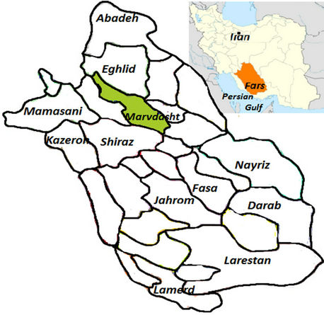
Figure 1. Location of Marvdasht plain in Fars province, Iran.
variation in the thickness of layers at the hillsides and the coincidence of the direction of created cracks and fissures with the direction of available faults in the studied area have been investigated as the main factors affecting the soil settlement. At the end of the paper, appropriate solutions for the land subsidence prevention and consequently the related damages reduction are presented.
2. History of Subsidence
One of the most important regional land subsidences in the world has been reported to be in California (United States) in 1969 [3]. There was about 8 m settlement due to the uncontrolled exploitation of groundwater for agricultural use. Until 1994 the amount of subsidence increased to 10-meter for 50-meter water level drop in the region [4]. Such phenomenon has been observed in many parts of the world such as Mexico, Thailand, Japan, America [5], Shanghai [6] and other parts of the China in the past years [7].
In recent years the regional land subsidence related to the groundwater level dropping have been reported in many parts of Iran such as Sirjan [8], Zarand and Kerman [9,10] and Kashmar plain [11].
3. Description and Discussion
In this paper the parameters related to land subsidence are investigated by the observations and the analysis of field and regional status data. The geological data, the status of groundwater level, soil layers type and the depth of bedrock have been investigated for specified plain (i.e. damaged villages) from the obtained logs of drilling. The vulnerability of these areas has been assessed by using microtremor device for the measurement of Earth vibration.
3.1. Land Subsidence in Plains of Fars Province
Land subsidence has been reported in eight regions of Fars province: Marvdasht, Arzhan, Shiraz, Naghshe Rostam, Kuh Sepid, Safashahr sinkhole and Sormagh. One of the most important plains is Marvdasht plain located 40 km north of Shiraz between longitudes 52˚16' to 53˚30' and latitude from 28˚54' to 30˚26'.
The ground water level dropping and the structural status of the region are the main causes of general settlement in the plain. Near the Mountain hillside and the places with variable soil layering, especially under the villages and building areas, the subsidence is more noticeable and considerable continuous cracks with the depth even more than of 10 meters and the width more than 8 cm are observed. These cracks with their adjacent counterparts form a hypothetical strip with about 50 m width in the Mountain hillside. Shul village, Kamal Abad, Zangi Abad, Ghasem Abad and ancient monuments of Naqsh-e Rustam are located in this hypothetical strip. In this research Shul village has been investigated completely as a sample of the aforementioned areas.
3.2. Case Study
Shul Village is located southwest of Hossein Mountain hillside (Figure 2). The geological formations of this region consist of calcareous Dariyan and Soruk formations. The alluvial sediment of the village includes pebbles and cobblestones with some fine sediment in the range of clay size particles. The east part of the village is located on an unconsolidated alluvial consisting cobblestones with little silt, clay and sand. The west part is located in a floodplain including silt and clay with some amount of salt.
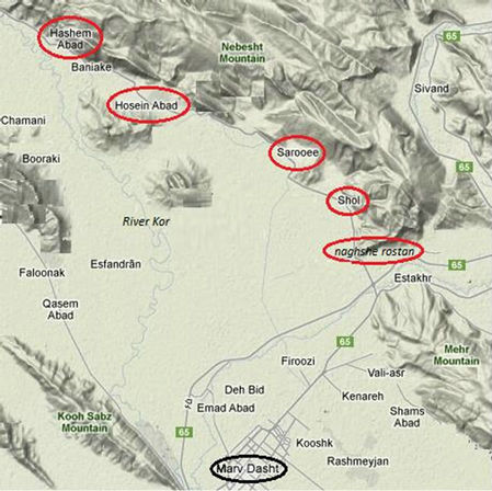
Figure 2. Location of the damaged villages near the mountain hillside in Marvdasht plain.
3.3. Investigation into Rainfall Status and Groundwater Level Drop
According to the records of rainfall stations in Iran, because of the reduction of precipitation from the water year 2005-06, the nation is entered to a new drought duration. The reduction continued until 2010-11, and after that a slight increase in rainfall amount has been observed (Figure 3). Considering all related hydrographs and the specified hydrograph of the aquifer located in Shul village (Figure 4), the Groundwater level dropping has been initiated from 2005-06 and continued with a mild rate to 2008-09. Then the rate of water drop speeded up and continued until the water year 2011-12. Indeed, by the investigation of rainfall status and the hydrographs in Marvdasht plain it can be seen that there exists a 6-year era of drought unprecedented in the past 50 years.
The piezometer located at Shul village shows 23.02 m drop of water surface during 6 years of drought from water year 2005-2006 to 2010-2011. The mentioned drop is the average value between all piezometer located around and within Shul village (Figure 4).
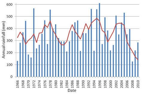
Figure 3. Annual rainfall curve based on the average values for 3 years.
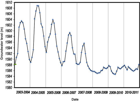
Figure 4. Hydrograph of the piezometer located in Shul village.
3.4. The Study of Layers and Bedrock Profiles
At the first step of study, the situation of all drilling wells (38 wells) and piezometers (8 piezometers) were specified on the map. Based on the obtained data from the drilling wells (logs of drilling, location), two profiles of the soil layering were plotted. The lengths of the obtained profiles were about 2.2 km at the hillside of Hossein Mountain. They were located at 1.5 km far from one another at the two sides of Shul village.
Due to the shallow depth of drilling wells and the presence of thick layers of alluvia, the depth of the bed rock is estimated from a limited number of wells shown in Figure 5 (thick blue lines). The depths of the bedrock obtained from the profiles at two sides of Shul village were the same. The thicknesses of the clay layers were also the same in both profiles. This consequently indicates the presence of thick clay layers and deep bedrock in the region.
The drought, dropping water table level and the presence of thick clay layers result in a significant amount of settlements and generation the lots of cracks in the region and consequently sever damages to the buildings in rural areas.
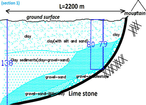
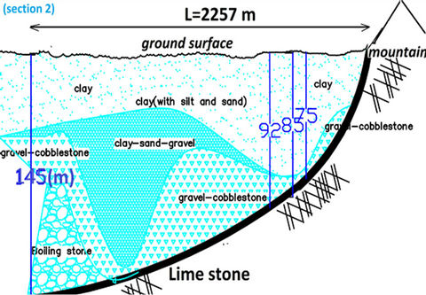
Figure 5. Soil layering profiling (horizontal scale: 1/100, vertical scale: 1/1000).
3.5. The Seismic Investigation and Study of the Effect of Faults on the Subsidence
Field studies over the cracked region showed that the direction of the main crack is along the side of Hossein Mountain. Shul village is also located on Garmabad Fault on the hillside of Hossein Mountain. The presence of this fault causes the anomalies in the sloped layering and the inversion of the slope in the southwestern side of Hussein Mountain anticline. The fault has appeared as a rupture zone in the domain. The precise status is shown in the geological map (Figure 6).
By mapping the situation of created cracks and gaps into the desired region, based on their geographical locations, it has been observed that the direction and vicinity of the cracks are along the fault. This indicates that the presence of fault accelerates the creation of cracks in conjunction with the groundwater level lowering.
According to the field observations the lime layers had the outcrops of 30 to 40 cm at Hossein Mountain. There were also settlements of 20 to 30 cm for the rural building near the Mountain which reduced by getting farther from the hillside. This reduction can be attributed to the effect of fault and the variation of alluvia thickness. Qualitatively, according to the field observations, 35 cm settlement can be considered for Shul village.
3.6. Vulnerability of Rural Buildings
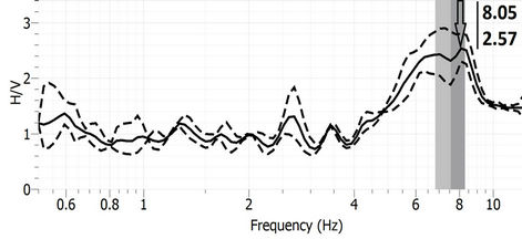
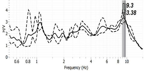
The predominant frequency, amplification, earth vulnerability indices and vulnerability indices of damaged or undamaged buildings (Figures 7 and 8) have been determined by microtremor in the vicinity of Shul village.
Tests have been conducted over the damaged reinforced structures located near the Mountain hillside and the undamaged structures far away from the cracks and gaps domain.
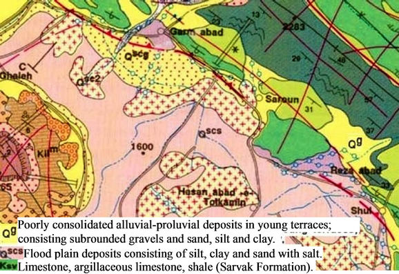
Figure 6. Geological map of Shul village.
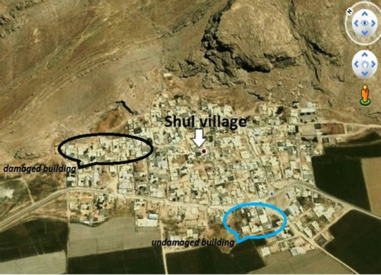
Figure 7. The location of damage and undamaged building.
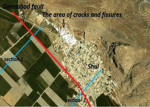
Figure 8. The area of cracks and fissures in Shul village.
According to the obtained data, the earth vulnerability index at the Mountain hillside (0.82) is lower than its counterpart (1.4) at the plain area (far from the Mountain) which confirms the accuracy of obtained results from the microtremor analysis considering shallow depth of bedrock near the Mountain and high thickness of the soil layer far from the Mountain. The vulnerability index can be calculated by the following equation.
 (1)
(1)
where ,
,  and
and  are respectively, the vulnerability index, magnification factor (i.e. H/V as shown in Figures 9 and 10) and the predominant frequency of the site based on the spectral ratio [12,13].
 (a)
(a) (b)
(b)
Figure 9. Spectral ratio H/V (ratio of horizontal component to the vertical component of the ground surface). (a) Damaged building; (b) Undamaged building
 (a)
(a)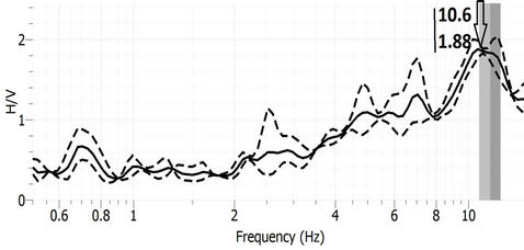 (b)
(b)
Figure 10. Spectral ratio H/V (the ratio of horizontal component of the building’s roof to the vertical component). (a) Damaged building; (b) Undamaged building
The vulnerability index of the rural building can be calculated by the average of vulnerability index, because most of the buildings in these areas are single storey buildings.
 (2)
(2)
where Kav, H, A and F are, the average of vulnerability index, height of building(m), magnification factor (i.e. H/V) and the predominant frequency of the building respectively [13,14].
As it is manifest from the figures, by considering the ratio of the horizontal component at the building’s roof to
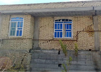
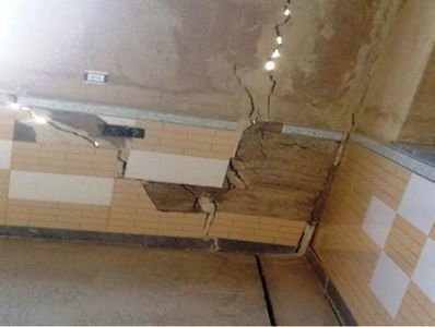
Figure 11. The created cracks inside and outside of the building due to land subsidence.
the vertical component of ground, the vulnerability index of the damaged structures is about 2.5 times higher than that of the undamaged ones, which shows the critical state of such structures with respect to the forthcoming earthquakes and future subsidence.
4. Conclusions
Based on the obtained data from site investigations, the most important factors which cause the land subsidence of Marvdasht plain and damage to rural buildings are water table drop due to excessive exploitation of water resources, the decrease of precipitation, presence of thick clay layers and fault existence. The coincidence of cracked zone with the fault vicinity, and also the existence of alluvial terraces are other weak points of the investigated region with respect to other areas. These result in the generation of deep cracks (more than 10 m depth) and wide openings (more than 8 cm width).
Considering the results of microtremor, the vulnerability index of damaged structures is high, which in turn shows the critical status of such structures. However by appearing extended cracks in the roofs, bases and walls of such structures as shown in Figure 11, their workability is lost and future financial and residential costs may be imposed.
The results of the present research show that for the prevention and control of damages to the structures due to the subsidence, the extraction of underground water resources should be managed properly, highly waterdependent plants should not be grown, unauthorized wells should not be drilled, farmers should be trained, irrigation systems should be improved and construction in the vicinity of cracked zone should be prevented.
5. Acknowledgements
The authors wish to thank Housing Association of Fars Province and the Research Center of Rural Housing for their sincere cooperation and financial support.
REFERENCES
- J. Pacheco, J. Arzate, E. Rojas, M. Arroyo, V. Yutsis and G. Ochoa, “Delimitation of Ground Failure Zones Due to Land Subsidence Using Gravity Data and Finite Element Modeling in the Queretaro Valley, Mexico,” Engineering Geology, Vol. 84, No. 3-4, 2006, pp. 143-160. doi:10.1016/j.enggeo.2005.12.003
- National Research Council, “Mitigating Losses from Land Subsidence in the United States,” In: J. Pacheco, E. Rojas, M. Arroyo, V. Yutsis and G. Ochoa, Eds., Delimitation of Ground Failure Zones Due to Land Subsidence Using Gravity Data and Finite Element Modeling in the Queretaro Valley, The National Academies Press, Washington DC, 1991, 58 p.
- J. F. Poland, “The Occurrence and Control Of Land Subsidence Due to Groundwater Withdrawal with Special Reference to the San Joaquin and Santa Clara Valleys, California,” PhD Dissetation, Stanford University, Palo Alto, 1981.
- K. J. Larson, H. Basagaoglu and M. A. Marino, “Prediction of Optimal Safe Ground Water Yield and Land Subsidence in the Los Banos-Kettleman City Area, California, Using a Calibrated Numerical Simulation Model,” Journal of Hydrology, Vol. 242, No. 1-2, 2001, pp. 79-102. doi:10.1016/S0022-1694(00)00379-6
- G. Y. Zhou and T. J. Esaki, “GIS Based Spatial and Temporal Predication System Development for Regional Land Subsidence Hazard Mitigation,” Environmental Geology, Vol. 44, No. 6, 2003, pp. 665-678.
- W. Quanlong, “Land Subsidence and Water Management in Shangha,” Master Thesis, Delft University, Delft, 2006.
- R. L. Hu, Z. Q. Yue, L. C. Wang and S. J. Wang, “Review on Current Status and Challenging Issues of Land Subsidence in China,” Engineering Geology, Vol. 76, No. 1-2, 2004, pp. 65-77. doi:10.1016/j.enggeo.2004.06.006
- A. Abbasnezhad, “Study of Environmental and Geological Conditions and Problems in Rafsanjan Plain,” Compact Geological Society of Iran Conference Papers, 1999.
- D. Rahmanian, “Land Subsidence and Created Gap Due to Groundwater Discharge in Kerman,” Journal of Water (in Persian), Vol. 6, 1987, pp. 35-42.
- S. M. VaeziNejad, M. M. Toufigh and S. M. Marandi., “Zonation and Prediction of Land Subsidence (Case Study-Kerman, Iran),” International Journal of Geosciences, Vol. 2, No. 2, 2011, pp. 102-110.
- G. Lashkaripour, “Study of the Formation of Cracks and Land Subsidence Reasons in West Plains of Kashmar,” Geological Studies, Vol. 1, No. 1, 2009, pp. 95-111.
- Y. Nakamura, “Vulnerability Indexes for Ground and Structures Using Microtremor,” Security Device Event Exchange, Istanbul, 1997.
- Y. Nakamura, J. Saita and T. Sato, “Development of Vulnerability Assessment Models Using Microtremor,” 6th EQTAPW Workshop in Kashikojima, Kashikojima, December 2003, pp. 1-6.
- Y. Nakamura, “A Method for Dynamic Characteristics Estimation of Subsurface Using Microtremor on the Ground Surface,” Quarterly Report of RTRI, Vol. 30, No. 1, 1989, pp. 25-33.