Vol.3, No.11, 927-935 (2011) Natural Science
http://dx.doi.org/10.4236/ns.2011.311119
Copyright © 2011 SciRes. OPEN ACCESS
Role of sedimentation in continental rifting from
comparing two narrow rift valleys the Salton Trough
and Death Valley-California
Musa Hussein*, Laura F. Serpa, Aaron A. Velasco, Diane Doser
Department of Geological Sciences, University of Texas at El Paso, El Paso, USA;
*Corresponding Author: mjhussein@utep.edu
Received 3 September 2011; revised 8 October 2011; accepted 19 October 2011.
ABSTRACT
To unravel the forces and better understand the
processes that drive continental rifting, and to
understand the role of sedimentation in pro-
moting the rifting process, we compare; the
different geological features of two narrow rifts,
the Salton Trough and Death Valley, California.
According to our models, the Moho is 22 km
deep to the southwest of the Salton Sea on
US-Mexico border and it deepens to 30 km in the
region west of the Salton Trough. In Death Valley,
the Moho is 24 km deep in the central part of the
basin and it deepens to 32 km outside of the
basin. The dome shaped Moho in both rifts is
suggested to be primarily the product of mag-
matic activity in the lower crust and upper man-
tle. Death Valley is narrow rift in the initial stage
of rifting with several sedimentary basins 2 - 4
km deep. In Death Valley magmatic (thermal)
forces appears to drive the rifting process. The
Salton Trough is wider than Death Valley and is
moving toward sea floor spreading. The depth
of the sedimentary basins ranges from 8 - 10 km
and a combination of thermal and sedimentation
appears to drive rifting processes in the Salton
Trough.
Keywords: Crustal Models; Data Incorporation;
Magmatic Underplating; Narrow Rifts
1. INTRODUCTION
Rifts have developed in continents at least since plate
tectonic was established early in earth’s history [1]. Ac-
tive rifting is characterized by regional uplift of the crust
and local development of normal faults and basins. Con-
tinued extension leads to seafloor spreading and freezes
the transitional crust in place, so the relative significance
of passive versus active rifting is preserved in deeply
buried units [2].
Comparative studies of rifts are a useful way to or-
ganize what is known, recognize what is not known, and
improve our understanding of the processes which led to
continental rifting [3]. Magmatism resulting from such
rifting can help refine our understanding of the strength
of the lithosphere, the state of the underlying mantle and
the transformation from rifting to sea floor spreading [4].
Many studies have highlighted the distinct differences
between rifts and other styles of extensional provinces
[5-10], and many experiments have been performed to
address the connection of mantle flow to continental
rifting [11,12]. The study of particular rift systems and
comparisons between rift systems has shown distinct
characteristics that imply fundamental differences in
geologic formation processes [3].
Incorporation of gravity models, receiver function
analysis, with previous seismic studies [13-15] provides
additional constraints on the composition and structure
of the crust and upper mantle. In particular, detailed
subsurface modeling of multiple data sets can provide
information on the driving forces of rifting, the structure
and magmatic history, and the characteristics that deter-
mine whether and how a rift might evolve into the next
stage as either an abandoned continental rift or an ocean
basin.
In this paper, we combine receiver function and grav-
ity data with pre-existing seismic models to illustrate the
role of sedimentation rate and sediments flux in promot-
ing the rifting process.
2. TECTONIC SETTINGS
The Salton Trough (Figure 1) is a modern example of
the evolution from continental to oceanic crust due to
rifting within a transtensional regime. The Salton Trough
is characterized by high heat flow; young volcanism and
the presence of several pull part basins [16]. It extends to
M. Hussein et al. / Natural Science 3 (2011) 927-935
Copyright © 2011 SciRes. OPEN ACCESS
928
Figure 1. Location map showing the Salton Trough area and
Death Valley area. Dashed line A-A' shows the location of the
Salton Trough crustal model. Dashed line B-B' shows the loca-
tion of Death Valley crustal model.
the northwest from the Gulf of California for a distance
of 250 km.
The Salton Trough contains about 10 km of sediments
deposited as alluvial debris, thin marine beds, and de-
posits from the ancestral Colorado River [17]. The pre-
sent day Salton Trough differs from analogous structures
to the south in the Gulf of California primarily because
of the large volume of sediments deposited in the Colo-
rado River delta during the past 5 m.y. [14].
Death Valley (Figure 1) is a well-studied example of
a rift basin where strike-slip deformation is occurring
contemporaneously with crustal extension. Death Valley
is a deep topographic basin that extends for about 200
km in north-northwest direction in southeastern Califor-
nia. Death Valley is a pull-apart basin [18] formed at a
right stepping bend in the right-lateral Death Valley fault
system. The geophysical data indicate that the valley fill
consisting of alluvium, lacustrine, and evaporite deposits
is about 3 km thick [19], and when combined with geo-
detic data from the Black Mountains, indicate a vertical
separation of approximately 5 km across the Black Moun-
tains fault zone at Badwater.
3. DATA
3.1. Receiver Functions
A receiver function is the seismic response of the
earth beneath a seismic station to an incoming P-wave.
In particular, a receiver function maps P-to-S converted
energy that occurs from impedance contrasts (i.e., layers
of different velocity and density) in the earth. First-order
information about the crustal structure can be derived
from the radial receiver function, which is dominated by
P-to-S converted energy from a series of velocity dis-
continuities in the crust and upper mantle [20]. Thus,
receiver functions can provide very good point meas-
urements of crustal thickness under a broadband station.
Receiver functions can be used to determine crustal
thickness and Vp/Vs ratios, and to determine the lateral
variation of the Moho depth [21].
We employ the receiver function technique using the
iterative deconvolution method of [22] and the stacking
approach described in [22]. In receiver function estima-
tion, the foundation of the iterative deconvolution ap-
proach is least squares minimization of the difference
between the observed horizontal component seismogram
and predicted signal generated by convolution of an it-
erative updated spike train with the vertical component
seismogram [22]. We compute receiver functions using
the iterative time deconvolution with Gaussian width
(Ga) factors of 2.5, 1.75, and 1 which is equivalent to
applying low pass filters with cutoff frequencies of 1.2,
0.9, and 0.5 Hz, respectively.
We collected waveforms of teleseismic earthquakes
with M > 5.5 from 27 broadband seismograph stations
(shown in Figure 2) for the Salton Trough and 13
broadband seismograph stations (shown in Figure 3) for
Death Valley, that recorded from 2000 to 2009. These
data were downloaded directly from the Incorporated
Research Institutes for Seismology (IRIS) Data Man-
agement Center using the Standing Order of Data, which
allowed for automated rotation of the horizontal compo-
nents to radial and transverse directions. From the
waveform data, we computed the radial and transverse
receiver functions using the iterative deconvolution me-
thod, keeping data with an 80% or greater fit. We also
manually inspected each radial receiver function to en-
sure quality. We then stacked the radial receiver func-
tions using the approach of [21].
The time separation t between Ps and P can be used to
estimate crustal thickness (H), given the average crustal
velocity:
22
22
11
Ps
sp
t
H
pp
VV
 
where p is the ray parameter of the incident wave. One
problem is the trade-off between the thickness and
crustal velocities, since tPs represents the differential
travel time of S with respect to P wave in the crust. The
dependence of (H) on Vp is not as strong as on Vs or
more precisely on the Vp/Vs ratio (K), which means the
uncertainty of (H) is < 0.5 km for a 0.1 km/s uncertainty
M. Hussein et al. / Natural Science 3 (2011) 927-935
Copyright © 2011 SciRes. OPEN ACCESS
929929
Figure 2. Contour map of the Moho depth (km) in the Salton
Trough based on receiver function data. Data were collected
from 27 stations (shown as triangles). Stations codes are shown
inside small squares beside each station.
in Vp; while a 0.1 change in (K) can lead to about 4 km
change in the crustal thickness [21].
3.2. Gravity Data
We obtained gravity data from the University of
Texas at El Paso (UTEP)-Pan American Center of Earth
and Environmental Studies (PACES) (http://www.re-
search.utep.edu/paces) that is currently hosted at the
CYBER-ShARE Center of Excellence at UTEP. The
gravity data were merged from a variety of surveys and
cover the US and the border region. The average error
for this data set ranges from 0.05 to 2 mGal (Al-Douri,
personal communication, 2010). Terrain corrections were
calculated by [23] of the US Geological Survey (USGS)
using a digital elevation model and a technique based on
the approach of [24]. A Bouguer gravity correction was
made using 2670 kg/m3 as the reduction density.
We used 40,784 Bouguer gravity points to create the
Bouguer gravity anomaly map of the Salton Trough
(Figure 4), and used 7930 Bouguer gravity points to
create the Bouguer gravity anomaly map of Death Val-
ley (Figure 5).
4. CRUSTAL MODELS
We use receiver function and gravity data to create
2.5D crustal scale models for the Salton Trough and
Death Valley. According to the receiver functions analy-
Figure 3. Contour map of the Moho depth (km) in Death Val-
ley based on receiver function data. Data were collected from
13 stations (shown as triangles). Stations codes are shown in-
side small squares beside each station.
sis [25], the Moho depth varies significantly between the
western edge of Peninsular Ranges at 38 km and the
western edge of the Salton Trough at 22 km. The pres-
ence of a steeply dipping Moho beneath the eastern
Peninsular Ranges strongly suggests the isostatic com-
pensation is through lateral variation in crustal or upper
mantle density rather than through an Airy root [26].
Bouguer gravity anomalies of the Salton Trough indi-
cate that the most important gravity anomalies trend in
the NW and NE directions. Large amplitude gravity
anomalies are observed over exposed crystalline rocks
and over Mesozoic and Tertiary sedimentary rocks.
Crustal model of the Salton Trough (Figure 6) is
~470 km long and cross the central regions of the Salton
Trough. The depth to the Moho, according to the re-
ceiver function, varies from 38 km under Peninsular
Ranges to 25 km south of the Salton Sea, deepens to 32
km at the end point of the model (Moho depth of 22 km
is located to the south of our model). Density for the
upper crust varies from 2500 kg/m3 to 2600 kg /m3 and
in the middle crust density is 2750 kg/m3 increase to
2950 kg/m3 for the lower crust. Lower crust density re-
flects gabbroic composition of the lower crust or oceanic
crust which indicates a late stage of rifting.
We modeled a magmatic underplating (mixture of
upper mantle and lower crust material) at a depth of ~20
M. Hussein et al. / Natural Science 3 (2011) 927-935
Copyright © 2011 SciRes. OPEN ACCESS
930
Figure 4. Bouguer gravity anomaly map of the Salton Trough. Dashed line A-A' shows the location of
the crustal model of Figure 6. SD; San Diego, T; Tijuana, SF; San Felipe.
Figure 5. Bouguer gravity anomaly map of Death Valley. Dashed line B-B'
shows the location of the crustal model of Figure 7. FCFZ; Furnace Creek fault
zone, SDVFZ; Southern Death Valley Fault zone, GFZ; Garlock Fault Zone.
M. Hussein et al. / Natural Science 3 (2011) 927-935
Copyright © 2011 SciRes. OPEN ACCESS
931931
Figure 6. Interpretative model for profile A-A'. This model is about ~470 km long, cross the central
part of the Salton Trough.
km south of Salton Sea, reference [25] showed the same
magmatic body in lower Gila River at a depth of 27 km,
which may suggests the magmatic body extend with
greater depth to the southeast of the Salton Trough.
Magmatic underplating has been suggested to be the
cause of the uplift, melting, and recrystallization of the
lower crustal rocks and to produce extension and basin
sedimentation in the upper crust [14]. We infer mag-
matic underplating is an evidence for slip and activity
transfer from one location to another which is consistent
with [14,27,28]. The Salton Trough model shows varia-
tion in the thickness of the sediments and sedimentary
basins, thickness of sediments and sedimentary basins
ranges from 6 - 10 km.
In Death Valley the Moho appears to have a dome
shape, with the Moho depth in central Death Valley es-
timated to be 24 km and deepening to approximately 31
km outside the valley [29]. The Moho is shallow and
may form a flat-topped dome centered beneath the south-
ern and central Death Valley basins. The flat topped dome
peaks beneath the area of active upper crustal extension
and is suggested, here, to be primarily the product of
magmatic activity in the lower crust and upper mantle.
Bouguer gravity anomalies of Death Valley show de-
crease of Bouguer gravity values in the Black Mountains
to the west and north of the Black Mountains. Low grav-
ity anomalies are likely caused by metasedimentary and
granitic rocks or by thicker crust or both.
Figure 7 shows the Death Valley crustal model that
runs through the central Death Valley Basin. Moho depths
are consistent with the receiver function data which
suggest the Moho is shallow and, possibly, domed or flat
topped in shape in central Death Valley basin (~24 km);
the flat topped shape beneath the area of active upper
crust extension is suggested to be primarily the product
of magmatic activity in the lower crust and upper mantle
[30]. Thickness of sediment and sedimentary basins
ranges from 3 - 5 km.
5. RIFTING STYLE AND RIFTING
FORCES
An important structural classification of rifts is by width
[31], with narrow rifts thought to form as necking insta-
bilities [32] where extension rates outpace thermal diffu-
sion and wide rifts are thought to require a mechanism,
such as lower-crustal flow in high heat-flow settings, to
inhibit localization of deformation [33]. The initial width
of an individual rift is a direct function of thickness of
the brittle upper crust [34]. Narrow rifts have a charac-
teristic width of 30 - 40 km; the width of wide rifts can
reach a 1000 km. Narrow rift width is less than 200 km
while wide rift width is greater than 200 km [4].
Observations of the magmatism that results from rift-
M. Hussein et al. / Natural Science 3 (2011) 927-935
Copyright © 2011 SciRes. OPEN ACCESS
932
Figure 7. Interpretative model for profile B-B'. The model is ~240 km long, and passes through the
Death Valley and Black Mountains anomalies.
ing range from volcanic margins with two to three times
the magmatism predicted from melting models to non-
volcanic margins with almost no rift or post-rift magma
tism. Such variations in magmatic activity are commonly
attributed to variations in mantle temperature. Over short
lateral distances, large differences in rifting style and
magmatism from wide rifting with minor synchronous
magmatism to narrow rifting in magmatically robust
segments [4].
The thermal regime drives rifting in Salton Trough
and Death Valley. We modeled a magmatic body to the
southwest of Salton Sea at a depth of 20 km that extends
for about 70 km in SW-NE direction (Figure 6). The
Death Valley model includes a magmatic body that under-
lies the central basin of Death Valley at depth of 24 - 25
km and extends for at least 160 km in NW-SE direction.
The rapid flux of sediments to rift basins exerts a
strong influence on deformation style, crustal rheology,
syn-rift magmatism, and rift architecture [4,35,36]. We
expect sedimentation rate and flux contribute to the rift-
ing process and considered to be a rifting driving force
in the Salton Trough but not Death Valley, according to
our models sedimentary basins are 6 - 10 km thick in
Salton Trough and 3 - 5 km in Death Valley. Summary
of the similar and different geological features between
the Salton Trough and Death Valley pull apart basins in
Table 1.
6. DISCUSSION
We created crustal scale models for the Salton Trough
and Death Valley by incorporating receiver function and
gravity data.
Receiver function analysis revealed a dome shaped
Moho in Death Valley that peaks beneath the area of
active upper crust extension and is suggested to be pri-
marily the product of magmatic activity in the lower
crust and upper mantle. In the Salton Trough there is
significant variation in Moho depth between the Penin-
sular Ranges and west margin of Salton Trough. The
steeply dipping Moho is a regional feature beneath the
eastern Peninsular Ranges, and that the compensation is
through lateral variation in crustal or upper mantle den-
sity rather than through an Airy root [26].
According the crustal models major faults (Elsinore,
San Jacinto, San Andreas, Imperial faults) in the Salton
Trough (Figure 6) extend for more than 12 km. While
major faults (Furnace Creek, Garlock, Death Valley
faults) in Death Valley (Figure 7) extends to about 12
km. Our models suggest that the extension is intense in
the weakest, thinnest area of the lithosphere which is con-
sistent with [37]. We modeled magmatic underplating as
M. Hussein et al. / Natural Science 3 (2011) 927-935
Copyright © 2011 SciRes. OPEN ACCESS
933933
Table 1. Summary of comparison between the Salton Trough and Death Valley.
Geologic Feature Salton Trough Death Valley
Length ~250 km ~200 km
Width
Narrow rift, but wider than Death Valley the width of Salton
Trough is 20 km in the north increase to 60 km to the south,
especially Southern Salton Sea area.
Narrow (8 to 25 km) depression.
-Rifting Stage Well developed
Moving toward sea floor spreading
In its initial stage of rifting mostly will
not develop to further stage no evi-
dence for extensional activity.
-Densities High crustal density (Gabbroic) Less than the Slaton Trough.
-Depth to the Moho 22 km to the southwest of the Salton Sea on the US-Mexico
border, and deepens to 32 km to the west and east
24 km central Death Valley and deepens
to 32 km (dome in shape).
-Sediments and metasedimenatry
The Salton Trough contains about 10 km of sediment deposited
from the ancestral Colorado River The present day Salton
Trough differs from analogous structures to the south in the
Gulf of California primarily because of large amounts of
sediment deposited through the growth of the Colorado River
delta. This sedimentation may play a strong role in reducing
the apparent structural relief in the Salton Trough.
The sedimentary basins in Death Valley
as isolated, discontinuous depressions,
deeper than 1 km and often more than 3
km; these basins have steep margins
often around their entire perimeter, and
typically horizontal dimensions of 5 - 15
km [33].
-Major Faults Extends for more than 12 km Extends for about 12 km
-Rifting Driving Force Combination of thermal and sedimentation Thermal
a magmatic body which is inferred to be a mixture of
lower crust and upper mantle material, to fit this body to
our models we presumed the density of this body to be
3100 kg/m3, this deeper magma extends for at least 160
km in NW-SE direction in Death Valley [29] and ex-
tends for 70 km in SW-NE direction in Salton Trough.
The sedimentary basins in Death Valley have been
described [38] as isolated, discontinuous depressions,
deeper than 1 km and often more than 3 km; these basins
have steep margins often around their entire perimeter,
and typically horizontal dimensions of 5 - 15 km. The
Salton Trough contains about 10 km of sediments de-
posited as alluvial debris, thin marine beds, and deposits
from the ancestral Colorado River [17]. Sedimentation
rate and sedimentary and metasedimantary rocks thick-
ness, and the difference in density between the lower and
upper most crust may reflect the role of sedimentation as
a rifting force in the Salton Trough. The Colorado River
has delivered a large volume of sediments to the Salton
Trough over the past 5 - 6 m.y., supplying felsic material
that is quickly buried and metamorphosed to form a new
generation of crust transferred from the craton interior
[39]. The seafloor expression is masked by sediment
thickness [4]; thick sediments gives the impression of
wider rift, for example Salton trough is 20 km wide in its
northern part and 60 km wide in its southern area [40],
and cover with thick sediments from sedimentation flux
from Colorado river. Four main processes affect conti-
nental extension: 1) thinning of the crust and lithosphere
2) diffusion of heat 3) flow of lower crust, and 4) sedi-
mentation [36,37]. Sediments are one of the main re-
corders of tectonic events, and also affect the way com-
pression or extension proceeds. The weight of sediments
reduce the difference in crustal buoyancy forces caused
by local crustal thinning allowing the rift to extend more
easily in a narrow rift mode [36]. Large inputs of sedi-
ments may have a thermal blanketing effect [4] where
the continental crust is heated by being depressed to a
higher temperature regime thereby weakening it. Pre-
sumably, the thermal blanket would promote narrow
rifting in the areas of thickest sediments. Our models
suggest that the extension is intense in the weakest,
thinnest area of the lithosphere which is consistent with
[37].
7. CONCLUSIONS
Crustal scale models, and comparative studies help
better understand the process that drives continental rift-
ing. According to receiver function analysis the Moho is
concave upwards in both areas. Although the two rifts
are classified as narrow rifts based on their width, there
are significant differences, especially in the rifting driv-
ing force. Crustal models show a magmatic body under-
lies the central Death Valley basin, and a magmatic body
to the southwest of Salton Sea. Both magmatic bodies
play a significant role in heating, stretching, and extend-
ing the crust. Sedimentary flux, and sedimentation rate
and large density variation between upper and lower
crust provide an evidence for sedimentation force in the
M. Hussein et al. / Natural Science 3 (2011) 927-935
Copyright © 2011 SciRes. OPEN ACCESS
934
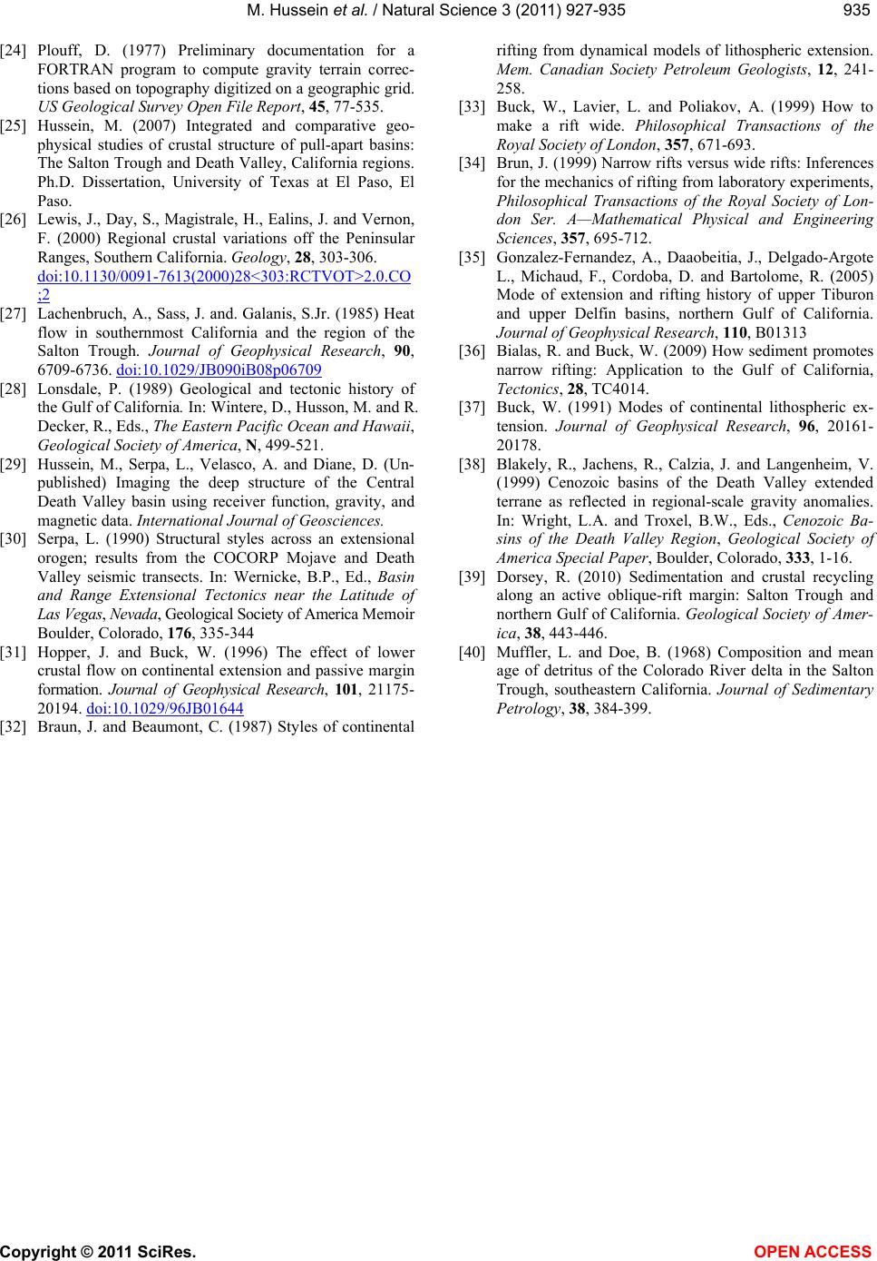
Salton Trough as a rifting driving force which is absent
in Death Valley. The Salton Trough is wider than Death
Valley and in its seafloor stage. We anticipate both rifts
are active, activity concentrated in the central basin of
Death Valley, and to the south and southwest of Salton
Sea in the Salton Trough, where the Moho is shallow
and geothermal activity is expected.
8. ACKNOWLEDGEMENTS
We would like to thank Dr. Terry Pavlis, Dr. William Cornell and
Dr. Vladik Kreinovich for helpful discussion. We would like also to
thank Dr. Raed Al-Douri, Carlos Montana for the technical support.
We would like also to thank anonymous reviewer for his constructive
comments. The work was partially supported by NSF grant number
HRD-0734825.
REFERENCES
[1] Adams, D. (1996) Integrated geophysical studies of con-
tinental rifts in west Texas and New Mexico. Ph. D. Dis-
sertation, University of Texas at El Paso, El Paso.
[2] Mickus, K., Stern, R., Keller, G. and Anthony, E. (2009)
Potential field evidence for a volcanic rifted marging
along the Texas Gulf Coast. Geology, 37, 387-390.
doi:10.1130/G25465A.1
[3] Keller, R., Khan, A., Morgan, P., Wendland, R., Bald-
ridge, W., Olson, K., Prodhel C. and Braile L. (1991) A
comparative study of the Rio Grande and Kenya rifts.
Tectonophysics, 197, 355-371.
doi:10.1016/0040-1951(91)90050-3
[4] Lizarralde, D., Axen, G., Brown, H., Fletcher, J., Gon-
zalez-Fernandez, A., Holbrook, W., Kent, G., Paramo, P.,
Sutherland, F. and Umhoefer, P. (2007) Variation in
styles of rifting in the Gulf of California. Nature, 448,
466-469. doi:10.1038/nature06035
[5] Buck, W. (1988) Flexural rotation of normal faults. Tec-
tonics, 7, 959-973. doi:10.1029/TC007i005p00959
[6] Wernicke, B., Axen, G. and Snow, J. (1989) Basin and
Range extension tectonics at the latitude of Las Vegas.
Nevada, Geological Society of America Bulletin, 11,
1738-1757.
[7] Keller, G., Morgan, P. and Seager, W. (1990) Crustal
structure, gravity anomalies, and heat flow in the south-
ern Rio Grande rift and their relationship to extensional
tectonics. Tectonophysics, 174, 21-37.
doi:10.1016/0040-1951(90)90382-I
[8] Lachenbruch, A. and Morgan, P. (1990) Continental
extension, magmatism and elevation: Formal relations
and rules of thumb. Tectonophysics, 174, 39-62.
doi:10.1016/0040-1951(90)90383-J
[9] Lense, C., Deverchere, J., Sankov, V., Lukhnev, A., Mi-
roshnichenko, A. and Levi, K. (1998) Crustal deforma-
tion in the Baikal rift from GPS measurements. Geo-
physical Research Letters, 25, 4003-4006.
doi:10.1029/1998GL900067
[10] Buck, W., Lavier, L. and Babeyko, A. (2003) A numeri-
cal model of lithospheric extension producing fault-
bounded basins and ranges. International Geology Re-
view, 45, 712-723.
[11] Dueker, K., Yuan, H. and Zurek, B. (2001) Thick-struc-
tured proterozoic lithosphere of the rocky mountain re-
gion. GSA Today, 11, 4-9.
doi:10.1130/1052-5173(2001)011<0004:TSPLOT>2.0.C
O;2
[12] Wilson, D., Leon, J., Aster, R., Ni, J., Schlue, J., Grand,
S., Semken, S., Baldridge, S. and Gao, W. (2002) Broad-
band seismic background noise at temporary seismic sta-
tions observed on a regional scale in the southwestern
United States. Bulletin of Seismological Society of Amer-
ica, 92, 3335-3341. doi:10.1785/0120010234
[13] Parsons, T. and McCarthy, J. (1996) Crustal and upper
mantle velocity structure of the Salton Trough southeast
California. Tectonics, 15, 456-471.
doi:10.1029/95TC02616
[14] Parsons, T., McCarthy, J. and Thompson, G. (2001) Very
different crustal response to extreme extension in the
southern basin and range and Colorado Plateau transition.
In: Erskine. M., Faulds, J., Bartley, J. and Rowley, G.B.,
Eds., American Association of Petroleum Geologists Pa-
cific Section Guidebook, 291-304.
[15] Fuis, G., Mooney, W., Healey, J., McMechan, G. and
Lutter W. (1984) A seismic refraction survey of the Im-
perial Valley region, California. Journal of Geophysical
Research, 89, 1165-1189.
doi:10.1029/JB089iB02p01165
[16] Larsen, S. and Reilinger, R. (1991) Age constraints for
the present fault configuration in the Imperial Valley,
California: Evidence for northwestward propagation of
the Gulf of California rift system. Journal of Geophysical
Research, 96, 10339-10446. doi:10.1029/91JB00618
[17] Crowell, J. (1989) Sedimentation and tectonics along the
San Andreas transform belt. In: Sylvester, A. and Cro-
well, J., Eds., Sedimentation and Tectonics of North
America Belt, Field Trips for the 28th International Geo-
logical Congress, Washington DC, American Geophysi-
cal Union, 32-35
[18] Burchfiel, B. and Stewart, J. (1966) Pull-apart origin of
the central segment of the Death Valley, California.
Geological Society of America Bulletin, 77, 439-442.
doi:10.1130/0016-7606(1966)77[439:POOTCS]2.0.CO;2
[19] Serpa, L., deVoogd, B., Wright, L., Willemin J., Oliver,
Hauser, E. and Troxel, B. (1988) Structure of the central
Death Valley pull apart basin and vicinity from the CO-
CORP models in the southern Great Basin. Geological
Society of America Bulletin, 100, 1437-1450.
doi:10.1130/0016-7606(1988)100<1437:SOTCDV>2.3.
CO;2
[20] Ammon, C., Randall, G. and Zandt, G. (1990) On the
nonuniqueness of receiver function inversions. Journal of
Geophysical Research, 95, 15303-15318,
doi:10.1029/JB095iB10p15303
[21] Zhu, L. and Kanamori, H. (2000) Moho depth variation
in southern California from teleseimic receiver functions.
Journal of Geophysical Research, 105, 2969-2980. doi:
10.1029/1999JB900322
[22] Ligorria, J. and Ammon, C. (1999) Iterative deconvolu-
tion and receiver function estimation. Bulletin of Seis-
mological Society of America, 89, 1395-1400.
[23] Webring, M. (1982) MINC, a gridding program based on
minimum curvature. US Geological Survey Open-File
Report, 43, 81-1224.
M. Hussein et al. / Natural Science 3 (2011) 927-935
Copyright © 2011 SciRes. OPEN ACCESS
935935
[24] Plouff, D. (1977) Preliminary documentation for a
FORTRAN program to compute gravity terrain correc-
tions based on topography digitized on a geographic grid.
US Geological Survey Open File Report, 45, 77-535.
[25] Hussein, M. (2007) Integrated and comparative geo-
physical studies of crustal structure of pull-apart basins:
The Salton Trough and Death Valley, California regions.
Ph.D. Dissertation, University of Texas at El Paso, El
Paso.
[26] Lewis, J., Day, S., Magistrale, H., Ealins, J. and Vernon,
F. (2000) Regional crustal variations off the Peninsular
Ranges, Southern California. Geology, 28, 303-306.
doi:10.1130/0091-7613(2000)28<303:RCTVOT>2.0.CO
;2
[27] Lachenbruch, A., Sass, J. and. Galanis, S.Jr. (1985) Heat
flow in southernmost California and the region of the
Salton Trough. Journal of Geophysical Research, 90,
6709-6736. doi:10.1029/JB090iB08p06709
[28] Lonsdale, P. (1989) Geological and tectonic history of
the Gulf of California. In: Wintere, D., Husson, M. and R.
Decker, R., Eds., The Eastern Pacific Ocean and Hawaii,
Geological Society of America, N, 499-521.
[29] Hussein, M., Serpa, L., Velasco, A. and Diane, D. (Un-
published) Imaging the deep structure of the Central
Death Valley basin using receiver function, gravity, and
magnetic data. International Journal of Geosciences.
[30] Serpa, L. (1990) Structural styles across an extensional
orogen; results from the COCORP Mojave and Death
Valley seismic transects. In: Wernicke, B.P., Ed., Basin
and Range Extensional Tectonics near the Latitude of
Las Vegas, Nevada, Geological Society of America Memoir
Boulder, Colorado, 176, 335-344
[31] Hopper, J. and Buck, W. (1996) The effect of lower
crustal flow on continental extension and passive margin
formation. Journal of Geophysical Research, 101, 21175-
20194. doi:10.1029/96JB01644
[32] Braun, J. and Beaumont, C. (1987) Styles of continental
rifting from dynamical models of lithospheric extension.
Mem. Canadian Society Petroleum Geologists, 12, 241-
258.
[33] Buck, W., Lavier, L. and Poliakov, A. (1999) How to
make a rift wide. Philosophical Transactions of the
Royal Society of London, 357, 671-693.
[34] Brun, J. (1999) Narrow rifts versus wide rifts: Inferences
for the mechanics of rifting from laboratory experiments,
Philosophical Transactions of the Royal Society of Lon-
don Ser. A—Mathematical Physical and Engineering
Sciences, 357, 695-712.
[35] Gonzalez-Fernandez, A., Daaobeitia, J., Delgado-Argote
L., Michaud, F., Cordoba, D. and Bartolome, R. (2005)
Mode of extension and rifting history of upper Tiburon
and upper Delfin basins, northern Gulf of California.
Journal of Geophysical Research, 110, B01313
[36] Bialas, R. and Buck, W. (2009) How sediment promotes
narrow rifting: Application to the Gulf of California,
Tectonics, 28, TC4014.
[37] Buck, W. (1991) Modes of continental lithospheric ex-
tension. Journal of Geophysical Research, 96, 20161-
20178.
[38] Blakely, R., Jachens, R., Calzia, J. and Langenheim, V.
(1999) Cenozoic basins of the Death Valley extended
terrane as reflected in regional-scale gravity anomalies.
In: Wright, L.A. and Troxel, B.W., Eds., Cenozoic Ba-
sins of the Death Valley Region, Geological Society of
America Special Paper, Boulder, Colorado, 333, 1-16.
[39] Dorsey, R. (2010) Sedimentation and crustal recycling
along an active oblique-rift margin: Salton Trough and
northern Gulf of California. Geological Society of Amer-
ica, 38, 443-446.
[40] Muffler, L. and Doe, B. (1968) Composition and mean
age of detritus of the Colorado River delta in the Salton
Trough, southeastern California. Journal of Sedimentary
Petrology, 38, 384-399.