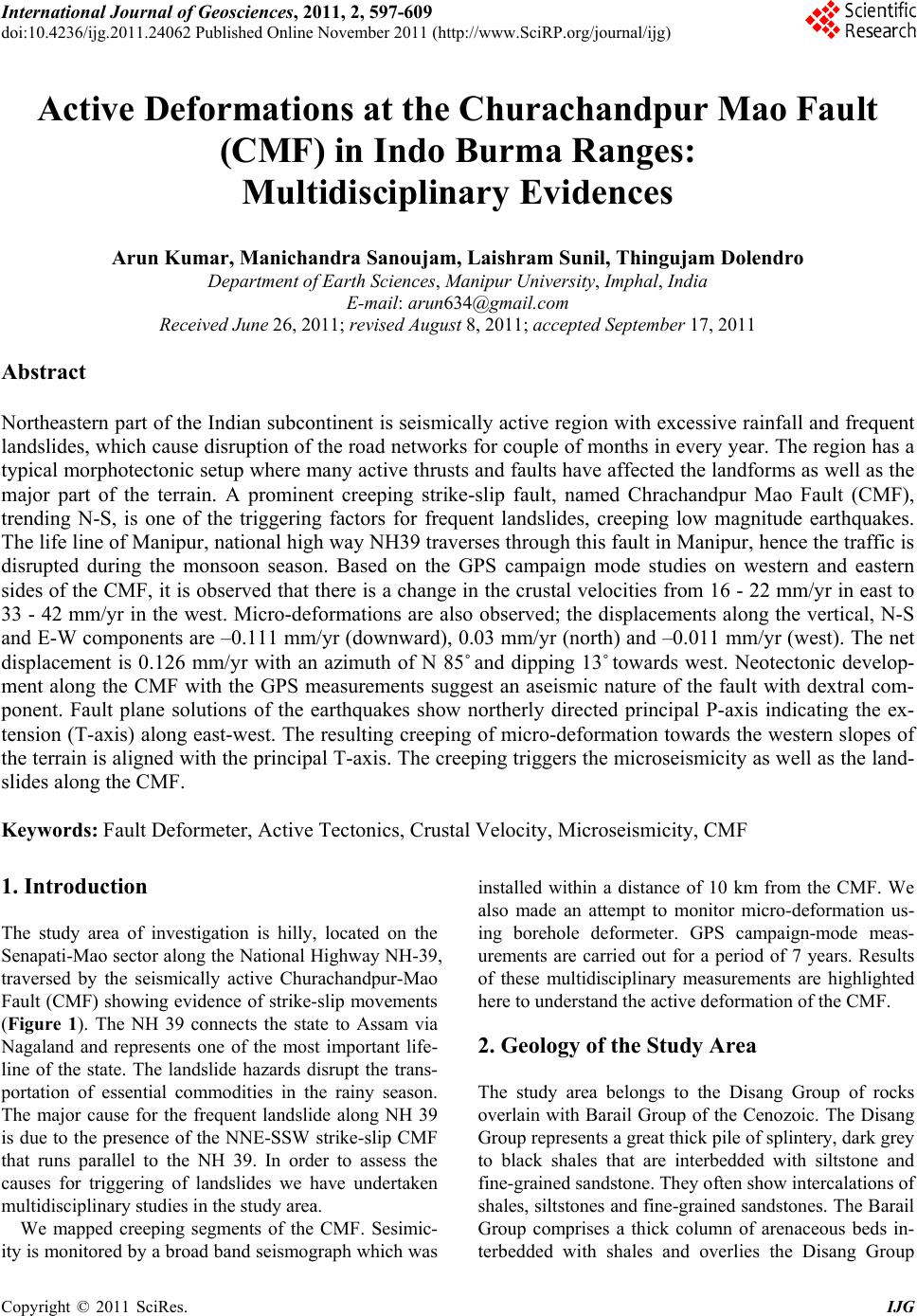
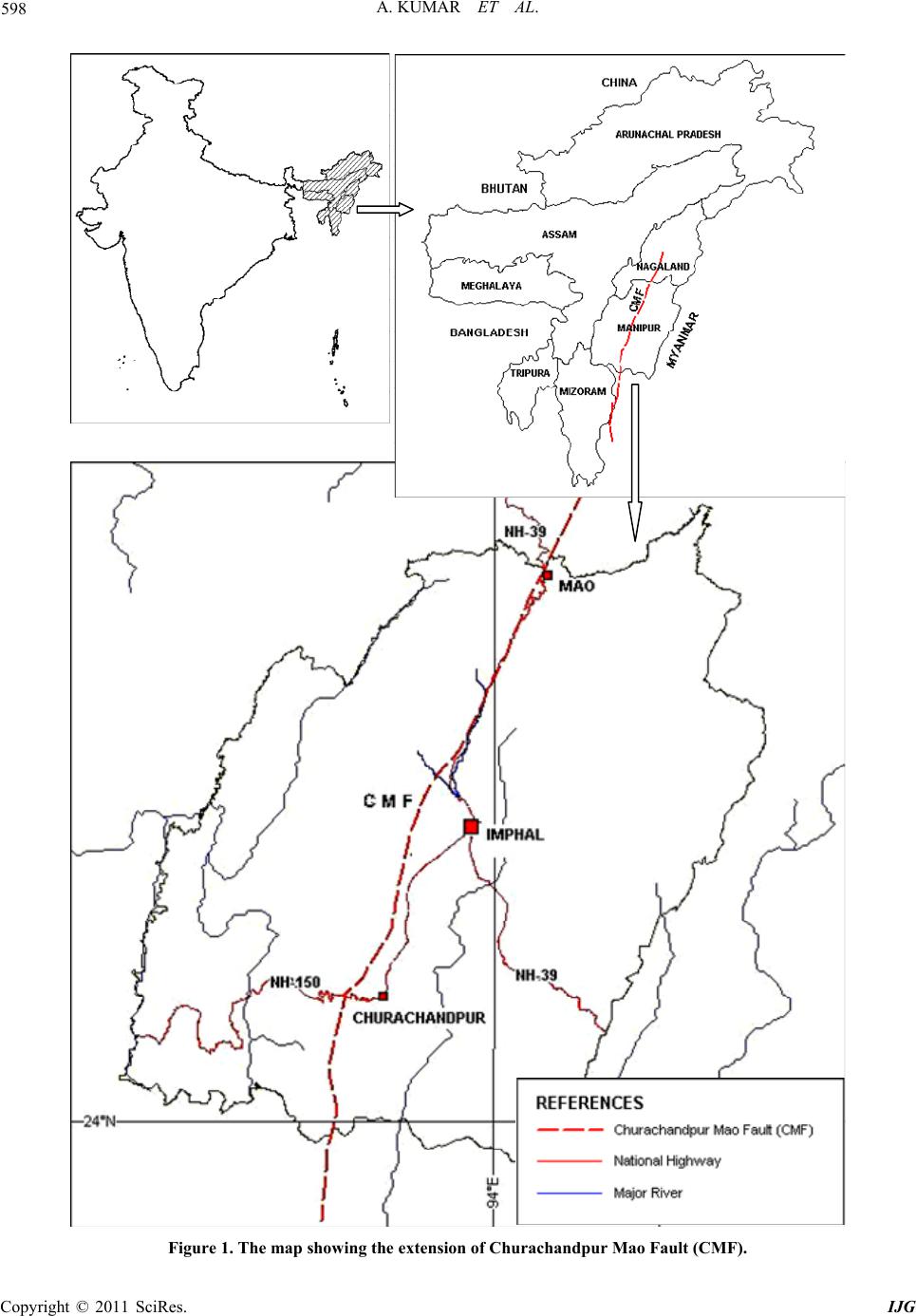
International Journal of Geosciences, 2011, 2, 597-609
doi:10.4236/ijg.2011.24062 Published Online November 2011 (http://www.SciRP.org/journal/ijg)
Copyright © 2011 SciRes. IJG
597
Active Deformations at the Churachandpur Mao Fault
(CMF) in Indo Burma Ranges:
Multidisciplinary Evidences
Arun Kumar, Manichandra Sanoujam, Laishram Sunil, Thingujam Dolendro
Department of Eart h Sciences, Manipur University, Imphal, India
E-mail: arun634@gmail.com
Received June 26, 2011; revised August 8, 2011; accepted September 17, 2011
Abstract
Northeastern part of the Indian subcontinent is seismically active region with excessive rainfall and frequent
landslides, which cause disruption of the road networks for couple of months in every year. The region has a
typical morphotectonic setup where many active thrusts and faults have affected the landforms as well as the
major part of the terrain. A prominent creeping strike-slip fault, named Chrachandpur Mao Fault (CMF),
trending N-S, is one of the triggering factors for frequent landslides, creeping low magnitude earthquakes.
The life line of Manipur, national high way NH39 traverses through this fault in Manipur, hence the traffic is
disrupted during the monsoon season. Based on the GPS campaign mode studies on western and eastern
sides of the CMF, it is observed that there is a change in the crustal velocities from 16 - 22 mm/yr in east to
33 - 42 mm/yr in the west. Micro-deformations are also observed; the displacements along the vertical, N-S
and E-W components are –0.111 mm/yr (downward), 0.03 mm/yr (north) and –0.011 mm/yr (west). The net
displacement is 0.126 mm/yr with an azimuth of N 85˚ and dipping 13˚ towards west. Neotectonic develop-
ment along the CMF with the GPS measurements suggest an aseismic nature of the fault with dextral com-
ponent. Fault plane solutions of the earthquakes show northerly directed principal P-axis indicating the ex-
tension (T-axis) along east-west. The resulting creeping of micro-deformation towards the western slopes of
the terrain is aligned with the principal T-axis. The creeping triggers the microseismicity as well as the land-
slides along the CMF.
Keywords: Fault Deformeter, Active Tectonics, Crustal Velocity, Microseismicity, CMF
1. Introduction
The study area of investigation is hilly, located on the
Senapati-Mao sector along the National Highway NH-39,
traversed by the seismically active Churachandpur-Mao
Fault (CMF) showing evidence of strike-slip movements
(Figure 1). The NH 39 connects the state to Assam via
Nagaland and represents one of the most important life-
line of the state. The landslide hazards disrupt the trans-
portation of essential commodities in the rainy season.
The major cause for the frequent landslide along NH 39
is due to the presence of the NNE-SSW strike-slip CMF
that runs parallel to the NH 39. In order to assess the
causes for triggering of landslides we have undertaken
multidisciplinary studies in the study area.
We mapped creeping segments of the CMF. Sesimic-
ity is monitored by a broad band seismograph which was
installed within a distance of 10 km from the CMF. We
also made an attempt to monitor micro-deformation us-
ing borehole deformeter. GPS campaign-mode meas-
urements are carried out for a period of 7 years. Results
of these multidisciplinary measurements are highlighted
here to understand the active deformation of the CMF.
2. Geology of the Study Area
The study area belongs to the Disang Group of rocks
overlain with Barail Group of the Cenozoic. The Disang
Group represents a great thick pile of splintery, dark grey
to black shales that are interbedded with siltstone and
fine-grained sandstone. They often show intercalations of
shales, siltstones and fine-grained sandstones. The Barail
Group comprises a thick column of arenaceous beds in-
terbedded with shales and overlies the Disang Group
598 A. KUMAR ET AL.
Figure 1. The map showing the extension of Churachandpur Mao Fault (CMF).
C
opyright © 2011 SciRes. IJG
599
A. KUMAR ET AL.
[1]. They are usually light-brownish grey, fine-to me-
dium-grained sandstone often interbedded with shales.
The contact between Disangs and Barails runs more or
less parallel to the NH 39. The various tectonic units are
shown in Figure 2. The litho contact runs nearly parallel
to the CMF. The CMF is a strike-slip in nature as evi-
denced by the type sections and geomorphic, topographic
and fault plane solutions. In the present study, the topog-
raphic and geomorphic expressions of the CMF are as-
sessed using a digital elevation model (DEM). The scarp
lines indicate evidence of the surface faults. These scarp
lines show a NNE-SSW to NNW-SSE trend which is
comparable with the regional trend of the CMF, which
often reactivates and is indicated by the scarp line as well
as by the drainage orientations. The majority of the
drainage networks follow the fault, as evidenced by the
Figure 2. Tectonics map of NE-India.
Copyright © 2011 SciRes. IJG
600 A. KUMAR ET AL.
straightness of the networks over distance, local mean-
dering and parallel drainage patterns, and sudden changes
in litho character. Some of the streams are aligned with
the lineaments which trigger the landslide and become
one of the factor for slope instability along NH-39.
3. Study of the CMF
3.1. Tectonics Features
The evolution of fault scarps, deformed rivers, marine
terraces and the morphology of the mountain fronts have
been studied for understanding neotectonic evolution of
an area [2-4]. It has been discussed long-term effects of
faulting and warping in the offsetting of river courses,
formation of lakes and development of meanders [5]. It
was suggested that the rise of the fault block across a
stream causes either the formation of a lake or swamp or
avulsion and development of an irregular or abnormal
drainage pattern [6]. Tectonic effect in the drainage pat-
tern of a river becomes obvious if it flows through con-
solidated rocks [7]. Recent studies have shown that the
detailed examination of drainage patterns can contain
much more information on fault evolution [8].
It is with the above background, we studied the drain-
age of the area along the CMF between Imphal and Mao
in Manipur, which are the tributaries of the tectonically
controlled Imphal and Barak River. The course of the
Imphal river and the Upper Barak River is controlled by
the CMF. The NNE-SSW trending CMF is regarded as a
strike slip structural discontinuity and mechanically as-
sociated with collision of the Indian plate and Burmese
micro-plate [9]. Creeping segments of a strike slip fault
are often characterized by high rates of microseismicity
on or near a fault [9]. Microseismicity releases only a
small fraction of slip occurring on the fault, with major-
ity of the accumulating elastic strain being released by
aseismic creep or by rare large events. The ability to dis-
tinguish between creeping and non-creeping patches on
faults and to determine the resulting accumulated slip
deficit is important in assessing the seismic hazards as-
sociated with faults [10]. Creeping faults were first iden-
tified along the San Andreas Fault in central California,
where cultural features were progressively off set [11]. It
has been noted that structures observed on certain types
of landslides are strikingly similar to those associated
with crustal scale tectonics [12]. These landslides may
provide useful analogues for the study of process in-
volved in crustal scale tectonics. In the present study,
detailed studies of individual landslide have not included,
beyond the scope of this paper.
In the present study the CMF has a regional extent of
300 km from the Kohima (Nagaland) to northern Mizo-
ram and displays creeping as well as microseismicity.
The database on earthquakes in the area indicates that the
triggering of earthquakes (4.0 and above) is not very
frequent. The existing database, which covers only the
past 30 years, indicates only nine 4.3 to 5.9 M magnitude
earthquakes occurred in the vicinity of the CMF. The
fault plane solutions indicate thrust and strike slip
mechanisms. The geodetic observations at selected two
sites at the two ends of the CMF indicate that the slip
rate in its southern part is 0.5 mm/year, whereas in the
northern part is 3.9 mm/year, as monitored during 2004-
2005. The southern part is less active while the northern
part is being deformed at higher rates. Similar studies
have also been conducted along the San Andreas and
Calavera faults, both of which indicate that plate motion
is accommodated principally by creep [13].
3.2. Active Tectonics and Topographic Analysis
A strong link between topography and active deforma-
tion is observed. Response of drainages to the lineaments,
fracture and faults is seen in the form of sharp angular
turns in the courses and at places beheading of streams.
Nearly all main streams have smaller parallel to sub-
parallel streams feeding them. As the streams cut into the
landscape, irregularity in the rate of incision leads to one
stream capturing its parallel nearby stream so as to give a
‘palm tree’ and ‘fork-like’ stream pattern and at places
‘beheaded’ streams [14]. The faults and lineaments
which were active earlier have now been superimposed
by the NNW-SSE trend. The incision in the streams of
the area is indicative of the tectonic activity along these
lineaments, fractures and faults. The drainage is mainly
influenced by the subsurface structural highs and lows.
The precise mechanisms responsible for such under
printing is, however, not clear. Deformation in the base-
ment might have induced fractures in the overlying allu-
vial deposits.
Various workers have characterised and associated
tectonic landforms by systematically deflected stream
channels, aligned drainages, linear valley and fault scarps
[15-18]. Offset stream channels provide probably, the
most convincing evidence for active strike-slip faulting
[19,20]. In the study area, the horizontal offset of stream
channel is quite demonstrable along the various
NNE-SSW trending faults. The movement along the
NNW-SSE trending transverse faults is manifested in the
displacement of courses of tributaries as ENE-WSW
trending streams towards NS. Exposures of younger ter-
race gravels are seen to be cut by the rivers. The pres-
ence of 3 - 4 m thick fluvial sediments (gravel) over the
river bed rock indicates active uplift. Fault scarps are
relatively young landforms constituting the most obvious
C
opyright © 2011 SciRes. IJG
601
A. KUMAR ET AL.
evidence of active faults all over the world [21]. The
streams of upper part of the Barak river record progres-
sive deformation in the CMF zone. Most of the streams
which cross through the fault regions have linear sections
above and below the faults, suggesting that they origi-
nally cut straight across the fault. Fluvial terraces at
places are displaced vertically, showing offset by about
35m in the area. Tectonic landforms including systematic
deflection of stream channels and ridges, alignment of
scarps and displacement of alluvial deposits show that
the area is undergoing active deformation (Figure 3).
3.3. Identification of CMF Using Topographic
Profile and Longitudinal Profiles of the
Rivers
An attempt is made to draw several topographic E-W
profiles using the SRTM data of the study area (Figure
4). The topographic sheet of 1:50,000 is used to prepare
the longitudinal profiles of the rivers draining towards
the Imphal valley (Figure 5). Both the profiles are com-
pared to delineate the extent of CMF in the study area.
Analysis of the longitudinal profiles is supplemented by
stream length-gradient index method of Hack [22]. The
successive segments are estimated along the stream using
the relation SL = (ΔH/ΔL)L, where ΔH/ΔL is the gradi-
ent of the studied segment and L is the total upstream
length. The sensitivity of this index to change in channel
slope makes it possible to evaluate the tectonic activity,
rock resistance and topography [23].
The drainage network of the Imphal River is markedly
asymmetric. The eastern side of the catchment includes
only few short small streams. The western side of the
catchment is in a sharp contrast to the eastern side, where
the maximum major tributaries are developed traversing
the CMF. Since the drainages are modified (deflected
from their original direction), the faulting appears to be
younger than streams. Similarly, the topographic profiles
exhibit number of knick points along the river channels
which indicates the location of the fault (Figure 6). Se-
lected field studies are carried out to pick up the evi-
dences of strike slip such as creeping, frequent landslide,
triangular facets, eroded scarps etc. Based on these evi-
dences, it is inferred that the study area is neotectonically
active and suitable for micro-deformation measurement
along the fault.
3.4. Micro-Deformation Measurement
A 3D fault deformeter, developed by a team of scientists
at the National Institute of Advanced Industrial Science
and Technology, Tsukuba, Japan is installed at the CMF
North
Creeping
Figure 3. Deformation is due to strike-slip movement.
Figure 4. Topographical profiles across the CMF.
Copyright © 2011 SciRes. IJG
602 A. KUMAR ET AL.
Figure 5. Longitudinal profile of the tributaries of Imphal river flowing across the CMF.
Figure 6. Longitudinal profiles of various major tributaries of Imphal River showing the deformation evidences (Knick
Points, aligned along the CMF).
since 2007. The 3D fault deformeter is an instrument
having the ability to measure relative movements in
joints/faults in three dimensions varying from some tens
of microns to about 1 m based on LVDTs. It is installed
in a borehole with or without casing depending on the
nature of the formation. A simple borehole televiewer is
used to locate the exact location of the fault and a small
hydraulic pump to secure the instrument on the rock
mass.
The observed micro-deformations are illustrated in
Figures 7(a)-(e). The displacement has an aseismic
character and the vertical component always prevails
over the horizontal one. The displacement along the ver-
tical, N-S and E-W components is –0.111 mm/yr
(downward), 0.03 mm/yr (north) and –0.011 mm/yr
west). The net displacement is 0.127 mm/yr with a mean (
C
opyright © 2011 SciRes. IJG
603
A. KUMAR ET AL.
(a)
(b)
(c)
(d)
Copyright © 2011 SciRes. IJG
604 A. KUMAR ET AL.
(e)
Figure 7. Displacement time series.
resultant azimuth of N084.83˚ - N264.83˚ (95% confi-
dence interval of ±1˚) and dipping 13˚ towards west
(Figure 8).
3.5. Crustal Velocity Estimates along CMF by
GPS Measurements.
Seismotectonic studies of the Indo-Myanmar region have
been attempted by several investigators [24-36]. A re-
view of the above literature suggests that there are con-
flicting views about the ongoing plate motion and geo-
dynamic process in Indo- Myanmar arc region.
In an existing status on the geodynamic processes us-
ing number of GPS campaigns under the GEODYSSEA
and NUVEL-1A model, it is suggested that relative mo-
Figure 8. Rose diagram displacement direction showing
Mean Azimuth of N084.83˚ - N264.83˚ (95% confidence
interval = ± 1˚).
tion between the India and Sunda plates is 35 - 37.5
mm/yr [37]. This motion is partially accommodated at
the Sagaing fault in Myanmar at 18 mm/yr, by right lat-
eral strike slip. Now the question is where the remaining
slip of 17 mm/yr is accommodated, at the IMR or else-
where?
The observed velocities (ITRF 2000 Reference) of the
western side and eastern side of the CMF are 49.38
mm/yr (N43.2˚) and 34.48 mm/yr (N36.3˚) respectively
showing the dextral nature of the fault (Figure 9). Based
on the fault plane solutions (Global CMT Project) of
earthquake data, the principal P-axis is towards north,
indicating the compression direction, resulting the exten-
Figure 9. Crustal velocity estimates (ITRF 2000 reference)
computed from 5 campaigns (2004-2010).
C
opyright © 2011 SciRes. IJG
605
A. KUMAR ET AL.
sion along east-west. The resulting creeping of micro-
deformation towards the western slopes of the terrain is
aligned with the principal T-axis (Figure 10).
Taking Indian plate as reference, the GPS stations lo-
cated in the west of CMF show almost no motion, as if
they are located on the Indian plate, whereas stations in
the east show motion of 16 - 22 mm/year towards south
to SSW. The change in velocity in eastern and western
regions occurs at the CMF. Thus it can be inferred that
the fault appears to be active. Motion across the CMF
appears to be predominantly dextral (i.e., right lateral
strike slip), implying no significant subduction across the
fault. The change in velocity across the fault is not grad-
ual, and appears to be sudden, which implies that this
boundary is aseismic in nature [38].
4. Seismicity
The seismicity of IMR region is characterised by high
Figure 10. P-axis and T-axis azimuth (Global CMT Project).
seismic activity with low to medium magnitude earth-
quake, shallow to intermediate depth mostly with strike
slip and thrust mechanism [39]. Since the CMF appears
to be aseismic based on the crustal velocity measure-
ments, micro-deformation and neotectonic activities, we
have observed the microseismicity as well as seismic
events by a existing Broad band seismic network. Based
on the seismic events from the existing seismic network,
a depth section is drawn across the CMF (Figure 11).
From the section it is evident that, the seismic activity on
either side of the CMF can be seen, and the seismic ac-
tivity beneath the CMF is low. Focal mechanism of the
epicenters depicts domination of thrust mechanism on
the eastern side of CMF and strike-slip dominates on the
western side of the CMF. The CMF seems to be demar-
cating boundary between the two mechanisms.
It is also evident that, most of the events (>4.5 M)
originates from the Indo-Myanmar Arc region, which are
inter-plate events (Figure 9). It may be noted that only
microearthquakes (magnitudes < 3.0) are recorded in and
around the CMF by the local network (Figure 12). It is
observed that most of the strike-slip fault such as Hay-
ward fault and southern Calaveras faults in San Fran-
cisco produces the microseismicity. However, micro-
seismicity triggers in both seismic as well as aseismic.
Strike-slip fault [40]. It is evident from the present mi-
croseismic records, creeping, landslides and surface mi-
cro-deformation that the CMF is a aseismic strike-slip
fault.
P
T
5. Discussion
Based on the present investigations on neotectonic ac-
tivities, microdeformations, crustal deformation and seis-
mic data analysis, it is observed that the CMF is a large,
NNE-SSW trending right lateral strike slip fault. The
field evidences on deflections of the rivers which trav-
erse through the fault show numbers of knick points. It
appears that the fault reactivation is comparatively
younger than the drainage and topography as both of
these have been severely deformed.
Based on the four years deformeter data, displacement
along the vertical, N-S and E-W components, the net
displacement of 0.127 mm/yr is with a mean resultant
azimuth of N084.83˚ - N264.83˚ (95% confidence inter-
val of ±1˚) and dipping 13˚ towards west are estimated.
We have compared the other strike slip fault such as lo-
cated in Czech Republic as Sokolsky Ridge-NE part of
Rychlevske Mts. However, San Andreas Fault in Cali-
fornia is one of the most prominent strike slip fault,
which is seismically active and creeping fault. The
creeping triggers the microseismicity. The manifestation
f neotectonics in the relief, zone of enhanced erosion, o
Copyright © 2011 SciRes. IJG
A. KUMAR ET AL.
Copyright © 2011 SciRes. IJG
606
Figure 11. Plot of hypocenters across the Churachandpur Mao Fault (24.5˚N Latitude with a window of 1˚) showin g the low
seismic activity below the CMF (data source: Seismological Observatory, Manipur University, Imphal; NGRI, Hyderabad,
IMD, New Delhi and NEIST, Jorhat; and the Focal Mechanism solutions are from Harvard Global CMT project).
Figure 12. Plot of epicentres within 20 km from the CMF triggered during 2009-2010 (source: Seismological Observatory,
anipur University, Imphal. M
607
A. KUMAR ET AL.
Figure 13. Creeping along the CMF (Southern Churach-
andpur).
linear arrangements of drainage lines, frequent land-
slides and coalescing alluvial fans are observed along
the fault.
These micro-deformation rates are comparable with
the Idrija and Rasa faults, W Slovenia [41], –0.24
mm/years and left-lateral displacement of +0.16
mm/year. The micro-deformation studies have been
useful to define the CMF as aseismic with other studies
such as neotectonic field evidences, crustal velocity
and local seismicity. Aseismic characteristics of the
CMF is a useful outcome in this study; the creeping or
landslides along the western slope may not cause seri-
ous hazards. A seismically active strike slip fault, on
the other hand, is prone to the landslide as well as
earthquake hazards.
6. Conclusions
1) The CMF is a creeping right lateral strike-slip fault,
which triggers microseismicity in the area. Active de-
formation of the fault is well quantified/measured using
the fault deformeter.
2) The fault deformeter measurements have shown
displacement along the vertical, N-S and E-W compo-
nents; these are 0.111 mm/yr (downward), 0.03 mm/yr
(north) and –0.011 mm/yr (west). The net displacement
of 0.127 mm/yr with a mean resultant azimuth of
N084.83˚ - N264.83˚ (95% confidence interval of ±1˚)
and dipping 13˚ towards west.
3) A change in velocity is observed between the east-
ern and western parts of the CMF. As the change in
velocity across the fault is not gradual, this boundary is
inferred as aseismic in nature.
4) Microearthquakes are recorded in and around the
CMF. However, as these events are not related with the
CMF as recorded by the deformeter, the fault appears
to be aseismic in nature.
7. Acknowledgements
The financial assistance provided by Ministry of Earth
Sciences and Ministry of Science & Technology Gov-
ernment of India to carry out the present investigations
is thankfully acknowledged. The authors are thankful
to Dr. Vineet Gahalaut of NGRI, Hyderabad to provide
the useful discussions in crustal deformation studies.
8. References
[1] P. Evans, “The Tertiary succession in Assam: Geology
and Metallurgy Institute of India,” Transactions in Me-
neralogy, Vol. 30, 1932, pp. 174-233.
[2] M. Morisawa and J. T. Hack, “Tectonic Geomorphol-
ogy,” Allen and Unwin, Boston, 1985.
[3] D. Merritts and T. Hesterberg, “Stream Networks and
Long Term Surface Uplift in the New Madrid Seismic
Zone,” Science, Vol. 265, No. 5175, 1994, pp. 1081-
1084. doi:10.1126/science.265.5175.1081
[4] C. A. Keller and N. Pinter, “Active Tectonics: Earth-
quake, Uplift and Landscape,” Prentice Hall, Upper Sad-
dle River, 1996.
[5] J. Tricart, “Structural Geomorphology,” Longman, Lon-
don, 1974.
[6] C. R. Twidale, “Structural Landforms,” Australian Na-
tional University Press, Canberra, 1971.
[7] S. A. Schumm, J. F. Dumont and J. M. Holbrook, “Ac-
tive Tectonics and Alluvial Rivers,” Cambridge Uni-
versity Press, New York, 2000.
[8] M. Goldsworthy and J. Jackson, “Active Normal Fault
Evolution in Greece Revealed by Geomorphology and
Drainage Pattern,” Journal of the Geological Society,
Vol. 157, No. 5, 2000, pp. 967-981.
doi:10.1144/jgs.157.5.967
[9] A. Kumar and S. Manichandra, “Landslide Studies
along the National Highway (NH 39) in Manipur,”
Natural Hazards, Vol. 40, No. 3, 2007, pp. 603-614,
doi:10.1007/s11069-006-9024-y
[10] R. Malservisi, K. P. Furlong and C. R. Gans, “Using
Microseismicity to Map Creep on a Fault Plane: Hints
from Modeling the Hayward Fault, California (USA),”
Earth and Planetary Science Letters, Vol. 234, No. 3-4,
2005, pp. 421-435. doi:10.1016/j.epsl.2005.02.039
[11] F. Waldhauser and W. L. Ellsworth, “Fault Structure
and Mechanics of the Hayward Fault, California, from
Double-Difference Earthquake Locations,” Journal of
Geophysical Research, Vol. 107, No. B3, 2002, pp.
2054-2068. doi:10.1029/2000JB000084
[12] R. W. Fleming, and A. M. Johnson, “Structures Associ-
ated with Strike-Slip Faults That Bound Landslide
Elements,” Engineering Geology, Vol. 27, No. 1-4,
1989, pp. 39-114. doi:10.1016/0013-7952(89)90031-8
[13] J. C. Savage, and R. O. Burford, “Discussion of Paper
by C. H. Scholz and T. J. Fitch, ‘Strain Accumulation
Copyright © 2011 SciRes. IJG
608 A. KUMAR ET AL.
along the San Andreas Fault’,” Journal of Geophysical
Research, Vol. 76, No. 26, 1971, pp. 6469-6479.
doi:10.1029/JB076i026p06469
[14] J. Jackson, V. R. Dissen and K. Berryman, “Tilting of
Active Folds and Faults in the Manawatu Region, New
Zealand: Evidence from Surface Drainage Patterns,”
New Zealand Journal of Geology and Geophysics, Vol.
41, No. 4, 1998, pp. 377-385.
doi:10.1080/00288306.1998.9514817
[15] A. Okada, “Fault Topography and Rate of Faulting
along the Median Tectonic Line in the Drainage Basin
of the River Yoshino, Northeastern Shikoku, Japan,”
Geographical Review of Japan, Vol. 43, No. 1, 1980,
pp. 1-21. doi:10.4157/grj.43.1
[16] Q. Deng, S. Chen, F. Song, S. Zhu, Y. Wang, D. Jiao, B.
C. Burchfiel, P. Molnar, L. Royden and P. Zhang,
“Variation in Geometry and Amount of Slip on the
Haiyuan Fault Zone. China and the Surface Rupture of
the 1920 Haiyuan Earthquake, Maurice Ewing Series
6,” American Geophysical Union, Washington DC,
1986, pp. 171-182.
[17] Y. Q. Zang, P. Vergely and J. Mercier, “Active Faulting
in and along the Quinling Range (China) Inferred from
SPOT Imagery Analysis and Extension Tectonics of
South China,” Tectonophysics, Vol. 243, No. 1-2, 1995,
pp. 69-95. doi:10.1016/0040-1951(94)00192-C
[18] E. A. Keller, “Investigation of Active Tectonics: Use of
Surficial Earth Processes,” National Academy Press,
Washington DC, 1986, pp. 136-147.
[19] R. E. Wallace, “Note on Stream Channels Offset by the
San Andreas Fault, Southern Coast Ranges, California,”
Stanford University Publications in Geological Sci-
ences, Vol. 11, 1967, pp. 6-20.
[20] K. Sieh, “Slip along the San Andreas Fault Associated
with the Great 1857 Earthquake,” Bulletin of the Seis-
mological Society of America, Vol. 68, 1978, pp. 1421-
1428.
[21] C. R. Allen, A. R. Gillespie, Y. Han, K. E. Sieh, B.
Zang and C. Zhu, “Red River and Associated Faults,
Yunnan Province, China: Quaternary Geology, Slip
Rates and Seismic Hazard,” Geological Society of
America Bulletin , Vol. 95, No. 6, 1984, pp. 686-700.
doi:10.1130/0016-7606(1984)95<686:RRAAFY>2.0.C
O;2
[22] J. T. Hack, “Stream-Profile Analysis and Stream Gra-
dient Index,” US Geological Survey Journal of Re-
search, Vol. 1, 1973, pp. 421-429.
[23] E. A. Keller and N. Pinter, “Active Tectonics: Earth-
quake, Uplift and Landscapes,” 2nd Edition, Prentice-
Hall, Upper Saddler River, 2002.
[24] T. J. Fitch, “Plate Convergence, Transcurrent Faults,
and Internal Deformation Adjacent to Southeast Asia
and western Pacific,” Journal of Geophysical Research,
Vol. 77, No. 23, 1972, pp. 4432-4460.
doi:10.1029/JB077i023p04432
[25] P. Molnar, T. J. Fitch and F. T. Wu, “Fault Plane Solu-
tions of Shallow Earthquakes and Contemporary Tec-
tonics in Asia,” Earth and Planetary Science Letters,
Vol. 19, 1973, pp. 101-112.
[26] U. Chandra, “Tectonic Segmentation of the Burmese-
Indonesian Arc,” Tectonophysics, Vol. 105, No. 1-4,
1984, pp. 279-290.
[27] A. Y. Le Dain, P. Tapponier and P. Molnar, “Active
Faulting and Tectonics of Burma and Surrounding Re-
gion,” Journal of Geophysical Research, Vol. 89, 1984,
pp. 453-472.
[28] M. M. Saikia, “Seismic Activity in Northeastern Region
of India,” In Earthquake Prediction—Present Status,
1986, pp. 223-233.
[29] J. F. Ni, M. G. Speziale, M. Bevis, W. E. Holt, T. C.
Wallace and W. R. Seager, “Accretionary Tectonics of
Burma and the Three Dimensional Geometry of the
Burma Subduction,” Geology, Vol. 17, No. 1, 1989, pp.
68-71.
doi:10.1130/0091-7613(1989)017<0068:ATOBAT>2.3
.CO;2
[30] W. P. Chen and P. Molnar, “Source Parameters of
Earthquakes and Intraplate Deformation beneath the
Shillong Plateau and the Northern Indo-Burman Range,”
Journal of Geophysical Research, Vol. 95, No. B8,
1990, pp. 12527-12552. doi:10.1029/JB095iB08p12527
[31] M. Guzman-Speziale and J. F. Ni, “Seismicity and Ac-
tive Tectonics of the Western Sunda Arc,” In: A. Yin
and T. M. Harrison, Eds., The Tectonic Evolution of
Asia, Cambridge University Press, New York, 1996, pp.
63-84.
[32] N. P. Rao and M. R. Kumar, “Evidences for Cessation
of Indian Plate Subduction in the Burmese Arc Re-
gion,” Geophysical Research Letters, Vol. 26, No. 20,
1999, pp. 3149-3152. doi:10.1029/1999GL005396
[33] S. P. Satyabala, “Subduction in the Indo-Burma Region:
Is It still active?” Geophysical Research Letters, Vol.
25, No. 16, 1998, pp. 3189-3192.
doi:10.1029/98GL02256
[34] S. P. Satyabala, “Oblique Plate Convergence in the
Indo-Burma (Myanmar) Subduction Region,” Pure and
Applied Geophysics, Vol. 160, 2003, pp. 1611-1650.
[35] M. Radha Krishna and T. D. Sanu, “Seismotectonics
and Rates of Active Crustal Deformation in the Bur-
mese Arc and Adjacent Regions,” Journal of Geody-
namics, Vol. 30, No. 4, 2000, pp. 401-421.
doi:10.1016/S0264-3707(99)00074-5
[36] N. P. Rao, “Deformation of the Subducted Indian
lithospheric slab in the Burmese Arc,” Geophysical
Research Letters, Vol. 32, No. 5, 2005, pp. 3-7.
[37] M. Becker, E. Reinhart, S. B. Nordin, D. Angermann, G.
Michel and C. Reigber, “Improving the Velocity Field
in South and South-East Asia: The Third Round of
GEODYSSEA,” Earth Planets Space, Vol. 52, 2000,
pp. 721-726.
[38] L. Sunil, “Crustal Deformation Studies of Manipur
using Global Positioning System,” Unpublished Ph.D.
Thesis, Manipur University, Manipur, 2007.
[39] S. Manichandra, “Seismotectonic Studies in Manipur,”
Unpublished Ph.D. Thesis, Manipur University, Ma-
C
opyright © 2011 SciRes. IJG
A. KUMAR ET AL.
Copyright © 2011 SciRes. IJG
609
nipur, 2002, pp. 81-91.
[40] W. X. Du, R. S. Lynn, B. E. Shaw and C. H. Scholz,
“Triggered Aseismic Fault Slip from Nearby Earth-
quakes, Static or Dynamic Effect?” Journal of Geo-
physical Research, Vol. 108, No. B2, 2003, pp. 1-21.
[41] A. Gosar, “Monitoring of Micro-Deformations along
Idrija and Raša Faults in W Slovenia,” Geologija, Vol.
50, No. 1, 2007, pp. 45-54.
doi:10.5474/geologija.2007.004