Engineering
Vol.08 No.03(2016), Article ID:65038,33 pages
10.4236/eng.2016.83015
Hydro-Politics of the Tigris and Euphrates Basins
Nadhir Al-Ansari
Luleå University of Technology, Luleå, Sweden
![]()
Copyright © 2016 by author and Scientific Research Publishing Inc.
This work is licensed under the Creative Commons Attribution International License (CC BY).
http://creativecommons.org/licenses/by/4.0/


Received 1 March 2016; accepted 25 March 2016; published 28 March 2016
ABSTRACT
The supply of fresh water is essential to life, socioeconomic development, and political stability in Middle East. Turkey, Syria and Iraq are the main riparian countries in the Tigris-Euphrates basin. Turkey is the riparian hegemon for a long time due to its structural power and dominant river position. Iraq and Syria are the lower countries in the basin and for this reason they always like to ensure the quantity of water required to satisfy their requirements. The conflict between riparian countries is due to several factors. These are: population growth rate and food security, energy security, economic and technological development, political fragmentation, international water laws, water and management availability and public awareness. There have been a number of attempts to find a common ground on water issues between the main three riparian countries since 1920 but no agreement signed yet. Present situation is very bad in Syria and Iraq where thousands of people have no access to water and farmers are leaving their land because of draught. Such situation will definitely raise tension and might lead to war. To avoid this, a mediator that has the capability to bring all countries concerned to the negotiation table is required. In addition, Syria and Iraq are to adopt prudent strategic plan based on resources development theory to ensure good water management and minimum water loses.
Keywords:
Tigris, Euphrates, Hydro Politics, Iraq, Turkey, Syria

1. Introduction
The Middle East is characterized by its water shortage problem [1] - [5] where at least 12 countries have acute water scarcity problems with less than 500 m3 of renewable water resources per capita available [6] [7] . The supply of fresh water is essential to life, socioeconomic development, and political stability in this region. In 1985, UN Secretary General Boutros Boutrous-Ghali said that the next war in the Near East would not be about politics, but over water [8] .
Sumerians occupied southern Mesopotamia since the dawn of civilization about 8000 years ago. Mesopotamia’s plentiful water resources and lush river valleys served as the basis for the civilizing started at Sumer. In that region Sumerians invented the first form of irrigation to improve agricultural production on the lower Mesopotamian Plain. They also devised the first written communication, or handwriting. This work continued through the time of other rulers like Hammurabi (1792-1750 B.C.), Cyrus (550-530 B.C.), Darius (520-485 B.C.), Alexander (336-323 B.C.), and the Abbasids (750-1258). The Assyrians in 754 B.C. used the rivers for transporting grain while also deepening and straightening many of the existing canals. For this reason it is called the hydraulic civilization. Despite its productive wealth and prosperity for many millennia, Mesopotamia saw wave after wave of conflicts. This can be noticed through the myths, legends and historical accounts that survived from earlier times e.g. Epic of Gilgamesh [9] . Dispute was over access to water supplies or international attacks on water supply systems during wars [10] . Another example of such wars is the invasion of the Mongols in the thirteenth century, destroying a majority of elaborate canals systems built centuries before. After that until the nineteenth century, Mesopotamia has moved toward a more rural society, creating a huge dependence on irrigated agriculture for its survival.
The largest consumer of water across the Middle East is agriculture where it accounts for 66% of demand [11] and therefore the water shortage problem cannot be objectively analyzed nor adequately addressed without a thorough consideration of agriculture [12] . It was reported that one cubic meter of water can provide drinking water for one person for one year and the same quantity can produce only one kg of food grain when used for irrigation in a dry climate [13] . If we consider 10% transfer of water away from agriculture, it would produce a 40% increase in domestic water supply for Jordan [12] . Postel [14] argues that rather than diverting precious water to agriculture this water could be saved by importing the food/grain. However, this is not the case in many Middle Eastern countries which have unrealistic aspirations of food self-sufficiency and it would require a most fundamental change in national outlook [15] . Sadik and Barghouti [12] emphasized that the extent of the problem is so severe that “the future challenges in meeting the growing demands for water are beyond the capabilities of individual countries”. Mitigating supply shortfalls could be achieved by re-allocation of current agricultural supplies [1] . Future predictions suggest more shortages [3] [16] - [18] and depletion of groundwater resources [19] [20] . Present situation is very bad in Syria [21] - [25] and Iraq [26] - [30] . Future prospects are not better where Maddocks et al. (2015) showed that Iraq, Syria and Turkey will be among the most likely to be water-stressed in 2040. Iraq, Syria and Turkey were ranked 21, 25 and 27 respectively.
Despite all the existing problems we should remember what the UN Secretary General Ban Ki-Mun said about water conflicts “instead of seeing scare water as reason for competition or conflict we have to treat it as a challenge to collaborate” [10] [31] . In this paper an overview of the recent causes of the conflict is given and possible solutions are suggested.
2. Hydrology of the Tigris and Euphrates Basins
The catchments area of Tigris and Euphrates Rivers are shared by five countries: Iraq, Turkey, Iran, Syria and Saudi Arabia, Figure 1 and Table 1. Details of these basins can be found in [3] [32] [33] .
Several ancient civilizations in the Mesopotamia were supported by basin irrigation from the Tigris and Euphrates Rivers since 6000 B.C. during Sumerian time. The ancient irrigation system was so efficient where it

Table 1. The area of Tigris and Euphrates Basins.
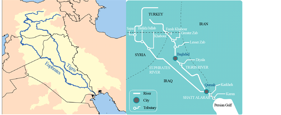
Figure 1. Catchments area of Rivers Tigris and Euphrates [2] [23] .
support wide spread cultivation of the land for many years without serious decline in land quality. Due to these marvelous water activities the term “hydraulic civilization” was used to describe this society.
Generally, the total annual flow of the Tigris and Euphrates Rivers is of the order 80 × 109 m3. This figure greatly fluctuates from year to year (Figure 2). Furthermore, floods and drought are themselves of variable magnitude. Such variations are due to changing metrological conditions. The period extending from October to February is referred to as variable flood period where discharges in both rivers fluctuate depending on intensity and duration of rainfall at their basins. This period is usually followed by what is known as steady flood period extending from March to April.
Flow records show that minimum and maximum annual flow of the Tigris was 19 × 109 m3 in 1930 and 106 × 109 m3 in 1969, while for the Euphrates it was 9 × 10⁹ m3 in 1974 and 63 × 109 m3 in 1969, respectively. Table 2 and Table 3 summarize the source and uses of water in both rivers.
2.1. River Euphrates
River Euphrates rises in the mountains of southern Turkey. It runs about 1178 km in Turkey before interring the Syrian territory where it runs 604 km to reach the Iraqi border. Inside Iraq the length of river is 1160 km. the total length of the river from Turkey to its confluence with the River Tigris south of Iraq is 2940 km, the total drainage area of the river catchments is 444,000 km2, Table 3, of which 28%, 17%, 40% and 15% lie in Turkey, Syria, Iraq and Saudi Arabia, respectively.
The Euphrates River rises east the Anatolian plateau between Wan lake and Black Sea in Turkey with two main tributaries (Figure 1):
a) Furat Su: This forms the northern tributary where it rises from the mountains situated northeast Ardhroom area with altitudes varying from 1800 to 3937 m above sea level. The total length of the tributary reaches 510 km.
b) Murad Su: This forms the southern tributary where it rises north of Wan Lake at areas having altitude of 2350 to 3519 m above sea level with a total length of 600 km. Both tributaries join together 5 km north of Keban city. At Keban area the Keban dam was constructed with a total reservoir capacity of 30.5 × 10⁹ m3. The average annual flow of the Euphrates River in this area is 672 m3/s. The united river length in Turkey is 455 km. The shape of the catchments of the river in Turkey is a fan shaped which collects runoff at rainy periods in a short period of time causing sudden flood peak. The Euphrates River inters the Syrian border near Jorablus and flow to Albokamal at the Syrian-Iraqi border. The catchment’s area of the river before entering Iraq reaches 201,000 km2.
In Syria, three tributaries join the Euphrates:
a) Sabor River: total length of the river is 108 km, joining the Euphrates, from the right, 30 km south of Tripoli city. The average discharge of the river is 3 m3/s.
b) Belaikh River: The length of this river is 105 km and joins the Euphrates from the left south of Raka city downstream Tabaka dam. The average discharge of the river is 36 m3/s and its catchment area is 14,400 km2.

Figure 2. Mean monthly flows of the Tigris and Euphrates Rivers at different gauging stations for different time periods [33] .
Table 2. Sources and uses of the Euphrates River (million cubic meters (MCM) per year).
c) Khabor River: The length of this river is 446 km. Its catchment area is 36,900 km2 and lies in Turkey and Syria. Four small streams, i.e. Jaja, Jabjab, Etehad Aracha Alsaghir and Etehad Aradha Alkabeer, join this river. The khabor join the Euphrates south of Dier Al-Zor city and its mean daily discharge is 55.8 m3/s and could reach 500 m3/s during flood.
There are several dams constructed on the Euphrates River in Syria. One of the main dams is called “Tabaka”. The storage capacity of this dam is 11.6 × 10⁹ m3 (life storage 7.4 × 10⁹ m3). The maximum, minimum and mean discharge of the river Euphrates at Tabaka dam is 8500, 450 and 1300 m3/s, respectively. There are three more large dams; Tersanah, Teshreen and Muhardah with storage capacities of 225 × 106 m3, 210 × 106 m3 and 50 × 106 m3, respectively. In addition, 84 other small and medium size dams exist. The largest among these
Table 3. Sources and uses of the Tigris River (MCM per year).
dams is known as Babalhadied with a storage capacity of 25 × 106 m3, while the storage capacity of the smallest dam is 30,000 m3.
The length of the river Euphrates in Iraq from the Syrian-Iraqi border at Hussaybah to its confluence with the Tigris River is 1160 km. once the river enters Iraq it trends toward the east and southeast to reach Anah city 100 km south of Hussaybah. The river then runs 220 km to reach Hit, with a river channel slope of 1:320 m. The channel is characterized by its shallow depth, large width and meanders. Islands are also noticed at the river channel. No tributaries join the Euphrates River inside Iraq apart from dry valleys originating from western desert. These valleys supply the river with flood water at rainy season from the desert. The minimum and maximum recorded discharges at Hit are 55 on 5/9/1973 and 7460 m3/s on 13/5/1969.
The river runs 63 km south Hit to reach Ramadi city with a width reaching 250 m. At this area, Ramadi barrage was constructed to supply Warrar stream with water. This stream supplies Habariya Lake with excess water from the Euphrates during flood period. The length of this stream is 8.5 km which is designed to discharge up to 2800 m3/s. Water stored in Habaniya Lake can brought back to the river Euphrates when required through Dhiban stream which is located 42 km south of Ramadi city. In case of continuous flood flow, Habaniya lake cannot accommodate huge volumes of water and thus it was connected to Razazah lake and then to Abudibis marsh to release excess water.
South of Ramadi city the river flows 72 km to reach Falujah city. A complex of canals system was constructed at this section of the river. A canal was dug from Tharthar large lake to supply the Euphrates River during drought periods; the canal joins the river 35 km north of Falujah city. The canal is designed to discharge water up to 1100 m3/s. It has a diversion which can supply excess water to the Tigris River if required. This diversion canal is 65 km long.
The Euphrates River runs south about 110 km to reach Hindiyah barrage. The river runs through fluvial deposits in this area. It should be mentioned however, that the Euphrates River channel inside Iraq upstream Hindiyah is higher by 7 m than Tigris river channel. This is due to the fact that the Euphrates runs on the edge of the western plateau. This phenomenon was used since ancient times to dug irrigation canals from the Euphrates River running toward the Tigris River.
At Hidiyah, the river is known as Hindiyah River where it flows south to reach Kifil city 18 km south of Hindiyah barrage. South of Kifil, the river splits to eastern channel (Shamiyah) which takes 40% of the flow and western channel (Kufa) taking the remaindering 60% of the flow. On shamiyah river there are various regulating schemes established for a number of irrigation projects, i.e. Danaieb Alshanafiyah, Shalal Danaieb Alshanafiyah, Khuman and Naghshiyah regulating schemes. This channel joins the Euphrates River again 8 km upstream Shanafiyah city. The distance from Kifil to Shanafiyah is 99 km.
As far as the other channel, the Kufa, it runs to Abusskhair city and splits into two main channels. The small channel (on the right of the main channel) supplies four small irrigation streams, the main channel south of Abusskhair as Mushkhab River where Mushkhab barrage was established. The water flows to the south to reach Qadisiyah city and it again splits and joins again to form one channel. This channel joins Shamiyah channel again at Shanafiya city.
The river continues to run south for 105 km where it reaches Simawah city. After that the river Euphrates reaches Nasiriyah city. It should be mentioned however that this section of the river (Simawah-Nasiriyah section) has a number of irrigation projects and small intake stream. South of Nasiriyah city the river runs toward Alshiyokh city and then enters Hammar Lake. Two channels leave Hammar Lake. The first joins the Tigris River at Qurna City while the other, the southern one, joins Shatt Al-Arab River at Karmat Ali.
2.2. River Tigris
The total drainage area of the Tigris River is 235,000 km2 distributed between Turkey (17%), Syria (2%), Iran (29%) and Iraq (52%) (Figure 1). The overall length of the river is 1718 km. It rises at the southeastern slope of Taurus Mountains at two sites, the western site is located near Diar city, 1500 m above sea level, with a discharge of 64 m3/s while the eastern site, known as Butman Su, near Sinan city a 270 m above sea level with a discharge of 96.3 m3/s. The river runs in a narrow valley bounded by Mardin Mountain range from the right and Raman Surat Hills from the left. Further down, another tributary (Karzan) joins the river near Bishwi village. The river runs south through rough mountainous area till it is joined by another tributary (Hazu) near ZEU village 240 km north of the Iraqi border. The discharge of this tributary is 59 m3/s. The river then runs in a plain area and joined by Butan Su River, with a discharge of 20.3 m3/s, to form the united Tigris River.
The river enters Iraq 4 km north Fieshkhabur near Zakha city. The Tigris is joined by its first tributary inside Iraq which is known as Khabur River. This tributary is 100 km long, it catchment area is 6268 km2 with an average, maximum and minimum discharge of 68 m3/s, 1270 m3/s (11/4/1963) and 8 m3/s (6-14/9/1962), respectively. The Tigris River runs south for about 188 km in a hilly area to reach Mosul city. At Mosul the average, maximum and minimum discharge of the river is 668 m3/s, 7740 m3/s (2/5/1972) and 85 m3/s (October, 1935) respectively. The elevation of the channel bed is 225 m above sea level.
About 49 km south of Mosul toward Sharkat city, the Tigris joins its biggest tributary, the Greater Zab. The catchment of this tributary lies in Turkey, Iran and Iraq. Its total length is 437 km with a mean, maximum and minimum discharges of 450 m3/s, 9710 m3/s (2/4/1969) and 60 m3/s (22/11 and 4/12/1958) respectively. It supplies 28.7% of the Tigris water.
The Tigris River runs south toward Fatha gorge. About 30 km north of Fatha, the Lesser Zab tributary joins the river Tigris. The total catchment area of this tributary is 22,250 km2 of which 5975 km2 lie in Iran and the remainder in Iraq. The total length of the river is 456 km. The mean, maximum and minimum discharges of Lesser Zab are 227 m3/s, 3420 m3/s on 8/3/1954 and 6 m3/s on 14/5/1964, respectively. The river Tigris mean, maximum and minimum discharges at Fatha gorge are 1349 m3/s, 16,380 m3/s on 3/4/1969 and 200 m3/s in October 1930, respectively.
Further south, the Tigris River enters the Mesopotamia plain 20 km north of Samara city and then Balad city. The Adhaim tributary joins the Tigris 15 km south Balad. The tributary drains an area of 13,000 km2 lying within Iraq. Its length is 330 km. The mean daily discharge is of the order of 25.5 m3/s; while the maximum recorded on 19/10/1960 reached 3520 m3/s. this tributary runs almost dry during June to November each year. The banks of the river Tigris south its confluence with Adhaim tributary are below the maximum flood peak level by 3 m from the left and 1.8 m from the right.
Further to the south, the river reaches Baghdad. At Baghdad the mean, maximum and minimum discharges are 1140 m3/s, 7640 m3/s on 12/2/1941 and 163 m3/s in October, 1955 respectively. The slope of the channel is very low i.e. 6.9 cm/km. About 31 km south of Baghdad, the last main tributary “Diyala” joins the Tigris. Diyala’s drainage basin is 31,896 km2 of which 20% lies in Iran and the rest in Iraq. The mean daily discharge is 182 m3/s while the maximum and minimum discharges are 3340 m3/s on 25/3/1954 and 12 m3/s on 7/9/1960, respectively.
Downstream the confluence of the Tigris-Diyala River, the Tigris channel is characterized by its large number of meanders. In addition, the river discharge steadily decreases downstream due to losses. These losses include evaporation, infiltration and mainly water withdrawal through irrigation canals. Important irrigation canals includes: Gharaf, south Kut city, Great Majar, South Emarah city, Mushrah and Kahlaa, South Emarah city, and Majariah canal, South Qalaat Salih. In addition, this stretch of the river is well known by the abundant occurrence of big marshes on both sides of the Tigris River. There are many small streams running from Iran toward Iraq where they discharge their water in the marshes e.g. Karkha stream discharging its water in Hiwazah marsh.
The Tigris channel reaches its minimum width at Kasarah area south of Emarah city. At Qalaat Salih the mean daily discharge of the river is 80 m3/s. Downstream this city the river joins the Euphrates River at Qurnah city forming Shatt Al-Arab River.
2.3. Shatt Al-Arab River
Shatt Al-Arab River is formed after the confluence of Tigris and Euphrates Rivers at Qurnah in Iraq (Figure 3). Its total length is 192 km and its drainage area is 80,800 km2. Its width is about 300 m near Qurnah and increases downstream to 700 m near Basra city and to about 850 m near its mouth at the gulf area. Karun and Karkha Rivers usually contributes 24. 5 and 5.8 billion cubic meters (BCM) annually respectively (Figure 3). This forms about 41% of the water of Shatt Al-Arab. Its annual discharge at Fao city reaches 35.2 × 10⁹ m3. Shatt Al- Arab River is characterized by its high sediments which resulted in the formation of large number of islands during its course.
3. Causes of the Conflict
Number of factors escalated the conflict over water issues in the Middle East.
3.1. Population Growth Rate and Food Security
Population growth rate is among the highest in Syria and Iraq (Table 4). The total population of the Middle East was about 20 million in 1750 this number tripled in 1950 and quadrupled to about 286 million in 1996 and expected to double within 30 years [34] . Accordingly, water allocation per capita decreases with the increase of population [35] . In addition, the region imports 50% of its food requirements [12] and this percentage is increasing with time [34] .
The largest consumer of water across the region is agriculture where it accounts for 66% of demand [2] [11] and therefore the water shortage problem cannot be objectively analyzed nor adequately addressed without a thorough consideration of agriculture [12] . If we consider 10% transfer of water away from agriculture would produce a 40% increase in domestic water supply for Jordan [12] . However, this is not the case in many Middle Eastern countries which have unrealistic aspirations of food self-sufficiency and in it would require a most

Figure 3. Water contribution to Shatt Al-Arab River [33] .
Table 4. Population characteristics within Tigris-Euphrates Basins (modified from [34] ).
fundamental change in national outlook [15] . Sadik and Barghouti [12] emphasized that the extent of the problem is so severe that “the future challenges in meeting the growing demands for water are beyond the capabilities of individual countries”. Mitigating supply shortfalls could be achieved by re-allocation of current agricultural supplies [1] . Future predictions suggest more shortages and depletion of groundwater resources [19] [20] [33] .
Iraq and Syria were grain exporters and now they are importers. The capability of these countries to produce grains is less than that of Turkey [36] . The goal of Turkey to turn its GAP area into a breadbasket will threaten the irrigation based agricultural potential of the lower riparian [36] . Syria tries to achieve self-sufficiency long time ago and continue to be so. It doubled its irrigated land and tried to use drip irrigation so that further increase can be achieved. Due to water scarcity, wheat yield decreased by 50% and much of the livestock had died. This situation caused many people to join insurgents so that they can survive [37] . As far as Iraq is concerned, the plan was to be grain exporter by 2017 [38] [39] . Iraq is importing all its food now [40] [41] . The country was one of the few regional cereal exporting countries in the region in the past. Now it is evident from food shops in Baghdad (for example) that everything is imported apart from dates, which implies that the agricultural outcome is disastrous [40] [41] . It should be mentioned however, that the goals of the governments in Syria and Iraq consider this plan of food self-sufficiency is of minor importance and priority is given to national security problems especially the threat of ISIS.
3.2. Energy Security
Turkey uses hydropower relatively more than Syria and followed by Iraq [42] . Due to the fact that Turkey is not an oil producing country, it does not like to rely on importing oil as an energy source. Turkey wishes to reduce its dependency on imports of expensive oil by producing at least 40% of its required energy from national hydroelectric resources [43] . GAP project is one of these sources where it is anticipated that it will reduce importing 28 million tons of oil [44] .
On the other hand, Iraq is oil exporter since early 20th century and Syria became oil exporter in 2001 while Turkey imports about 63% of its fuel. Syria relies on hydropower to generate electricity despite the fact that they have oil reserves and this gives Turkey the chance to threaten Syria by decreasing the discharge of the Euphrates using the GAP project. Despite the continuous declarations from the Turkish Government that GAP is purely a development project, it seems that there are number of internal and external goals involved as well [45] - [49] .
3.3. Economic Development
Syria and Iraq experienced rapid economic development and rising of the standard of living [35] due to the fast increase of oil prices. This raised the demand for water for domestic and industrial uses. In view of these developments the water claims of the three counties (Syria, Iraq and Turkey) add up to 149% of the total water available [42] . To achieve its development goals, Turkey is planning to use water. This was very clear when president of Turkey in 1992 declared at Ataturk dam opening ceremony that “Neither Syria nor Iraq can lay claim to Turkey’s rivers any more than Ankara could claim their oil… The water resources are Turkey’s, the oil resources are theirs. We don’t say we share their oil resources, and they can’t say they share our water resources” [50] . In addition, Turkey is trying to use water to improve its relationships with other countries by trading water. The proposed Peace Pipeline and Manavgat River project focus to trade water with Mediterranean and Middle East neighbors [51] .
Furthermore, the ongoing development in the Middle East led more than 50% of the population to move from rural to urban areas. This aggravates the water shortages problem where in urban areas the water consumption is 10 to 12 times its rate per capita as village dwellers [34] .
3.4. Technological Development
Technological developments had increased water losses where large dams were build which increased evaporation rates and huge quantities of water is lost in irrigation projects due to inefficient irrigation methods. Riparian countries within the Tigris-Euphrates basins do not use new technologies to save water in their agricultural practices. Syria tried to adopt new technologies in irrigation practices but it did not work because farmers could not adapt quickly to the new technologies [52] .
3.5. Political Fragmentation
After World War I the area had been divided into number of countries. Before that, the Ottoman Empire dominated much of the Middle East for 500 years. During that period, conflict among different people dampened. After that, ethnic consciousness increased which lead to growing disparities and rivalries in the region and all the people became more competitive and nationalistic. During the twentieth century cold war had a restraining effect on the likelihood of major conflicts, and this does not exist now. Surface waters and groundwater resources overuse and pollution became a source of friction and tension. Good examples are the 1967 war between Israel and Arab states where water was one of the underlying causes as well as the Israeli occupation of Lebanon in 1982 where they occupied Litani River and diverted its water. In addition, 40% of Israel water is extracted from aquifers beneath the West Bank and Gaza [34] . Future prediction models suggests that groundwater in depleting [19] [20] [33] as well as surface water [16] - [18] [53] [54] . Restoring the marshes [53] [54] and the growing demand for water in Turkey and Syria will lead to dry the Tigris and Euphrates Rivers in 2040 [55] .
3.6. International Water Laws
Existing international laws might be suitable for non-arid regions like Europe but they are inadequate for arid regions like the Middle East. Legal principle exists in these laws, but there is no legally binding international obligations for countries to share their water [56] . Accordingly, agreements depend upon the goodwill of the riparian in any particular drainage basin. In this case a number of factors can raise the conflict such as relative position of the country within the drainage basin, degree of national interest in the problem and the power (both internal and external) available for the country to pursue its politics [57] .
3.7. Water Availability
Turkey argues that the allocation per capita in Iraq and Syria in suitable for the requirements of people in these countries (Table 5) [58] .
3.8. Water Management
Water scarcity problem have been exacerbated due to poor water management [35] in the Tigris and Euphrates basin. Huge quantities of water are wasted through inefficient irrigation systems such as flood irrigation, unlined and/or uncovered canals as well as evaporation from reservoirs (Figure 4 and Figure 5). Extensive use of chemical fertilizers and pesticide in farming had affected the water quality of rivers and groundwater (Figure 4 and Figure 5). Dumping of industrial and domestic waste in the rivers increased the pollution of these rivers in particular at the downstream riparian. This causes dissatisfaction and frustration and crates irritation that might lead to conflict.
Table 5. Water allocation per capita per year in Turkey, Syria and Iraq (a [59] ; b [60] ).
In this context, these figures do not include certain problems like restoring the Iraqi marshes. Furthermore, when GAP project is completed these figures will be decreased.

Figure 4. Salinity variation along Euphrates River since 1996 [33] .
![]()
Figure 5. Salinity variation along Tigris River before 1983 and after 1995 [33] .
ESCWA [33] collected the information about the total dissolved solids (TDS) of the Euphrates River (Figure 4). At Ataturk dam the TDS is about 300 ppm. The salinity in Euphrates River at the Syrian-Iraqi borders is 600 mg/l which is already higher that the recommended level for irrigation (Figure 4) and it increases to more than 1200 mg/l (minimum) downstream at Samawah (World Bank, 2006; IMMPW, 2011).
Within Iraq, the source of most of the back irrigation water is from irrigation projects that are located in the central and southern parts of the country (1.5 million ha). Back irrigation water from these projects is directed to the main outfall drain which drains to the gulf in order to reduce the soil salinity [63] . Despite the presence of these drainage measures, the salinity increases downstream along the courses of the two rivers in conjunction with decreases in their discharges (Figure 6 and Figure 7). This situation overstressed the agricultural sector in the southern Iraq. Tracking the changes of Tigris River’s salinity shows that significant increase starts from Baghdad downward. This is due to the effect of the feedback from Tharthar depression toward Tigris River [64] . Where some of the Tigris flood flows is diverted at Samara Barrage to Tharthar depression which is highly
![]()
Figure 6. Variation of Discharges (Q) and Total Dissolved Solids (TDS) along Tigris River inside Iraq.
![]()
Figure 7. Variation of Discharges (Q) and Total Dissolved Solids (TDS) along Euphrates River inside Iraq.
saline (Figure 8), and then it is redirected for use in the river system with the salt washed from the depression. Recent estimates indicate that 4% of irrigated areas are severely saline, 50% are of medium salinity and 20% are slightly saline [65] . This forced the government to undertake a land rehabilitation program and a total of 700,000 ha were reclaimed. Later the situation deteriorated where recent estimates indicate that 4% of irrigated areas are severely saline, 50% are of medium salinity and 20% are slightly saline [66] .
3.9. Public Awareness
Conservation is a cost-effective means of securing future water supplies since security of freshwater is emerging as a worldwide issue due to growing population and limited supplies, coupled with diminishing availability due to inadequate management, deforestation and increasing pollution. To achieve secure and sustainable water for future generations, the efficiency of current water supply and usage needs to be improved. Such program should be an interactive movement in which different parties are engaged, each with their own roles, responsibilities and ways, to make their voices heard and create social pressure [67] .
Governments in the Tigris-Euphrates basins should adapt a multi-step framework for preparing an overall strategy and designing a public water awareness program that includes promotional activities, implementing the activities and monitoring and evaluating their effectiveness. As a first step is to educate politicians and policy makers; water planners and managers; and social marketers and educators about the importance of water conservation in the potable water supply sector and how it may be approached, so that they can take part in national water awareness program and promoting it to society as a whole. Professionals in the water sector and education officials should setup special curricula in schools by developing and finding ways to introduce the subject. The media can play an important role in raising awareness about the importance of water issues where the lack of public perception of the importance of proper water management and the ignorance of the impact of political and economic decisions of the long term guarantee of water resources are one of the biggest problems in the Middle East. Since agriculture is the highest water consumer in the region, farmers are to be educated on the use of new irrigation techniques that are suitable for arid regions.
It is believed that the countries concerned in the Tigris Euphrates Basins should adopt the outlines of the program set by [68] . These are:
What are the rules and regulations for water and wastewater permits?
How is the water produced and distributed?
How is the wastewater collected and treated?
How does your utility provide maintenance and repair services?
What kind of customer service does your utility provide?
What conservation measures are in place?
![]()
Figure 8. Total Dissolved Solids concentration at Samarra Barrage (the supply- ing point to Tharthar depression).
4. International Agreements
Tigris and Euphrates basins are shared different countries (Turkey, Syria, Iraq, Iran and Saudi Arabia). Iraq (in particular) and Syria are the lower countries in the basin and for this reason they always like to ensure the quantity of water required to satisfy their domestic, industrial and agricultural requirements. They also consider these basins as international “watercourses” which should be treated as an integrated entity by all the riparian users. Turkey regards the Euphrates River as “trans-boundary River” which is under its exclusive sovereignty until it flows across the border and when it joins the Tigris River to form Shatt Al-Arab River then it becomes an international river.
Turkey was the only country within the Euphrates basin (and one of the only three countries) that voted against the International Law Commission of the United Nation on the law of Non-navigational Uses of International Watercourses in 1997. Turkey also considers that the convention does not apply to them and for this reason it is not legally binding [69] . In addition, Turkey considers that Tigris and Euphrates Rivers are in one basin due to the fact that they join together to form Shatt Al-Arab River while Syria and Iraq consider them as separate basins. Turkey also likes to negotiate all the water resources in Syria and Iraq while Syria opposes to discuss the water resources of other rivers in Syria (Orontes River and upper headwaters of the Jordan including the Yamouk River). As far as Iraq is concerned, they also refuse to discuss the water coming from the Iranian valleys to Iraq. Turkey seek absolute territorial sovereignty on the Tigris and Euphrates water while Syria maintains a blend of the Harmon Doctrine called limited territorial sovereignty, and absolute territorial integrity, due mainly to the 24 percent of Euphrates river length in the country and 17% of drainage area [70] . Syria also laid claim to the Tigris, even though only 44 km run along their common border with Turkey.
There have been number of attempts to find a common ground on water issues between the main three riparian countries since 1920 but no agreement signed yet. The first treaty concerning the Tigris and Euphrates Rivers was signed between France as the mandatory power for Syria and Great Britain the mandatory power for Iraq in 1920. They agreed to establish a committee to examine and coordinate the use of the Euphrates and Tigris Rivers [33] [71] . One year later, another agreement was signed between Turkey and France (as mandatory for Syria) where it states in article 12 that Aleppo city can use the water of the Euphrates River. In 1923, the agreement known as Lausanne agreement was signed between Turkey and allied powers. In this agreement it was agreed that issues related to trans-boundary water should be dealt with separately and with mutual respect. It also includes a provision that Turkey must consult Iraq before undertaking any hydraulic works (article 109) [33] [71] . Treaty of Friendship and Good Neighborly Relations was signed between Turkey and Allied powers in 1926. In this treaty they agreed to cooperate together to use the Euphrates basin. Then in 1930, the Turko-French Protocol (on Commission of Delimitation) was signed between Turkey and France (Syria) states that the border between the two countries is to follow the thalweg principle, establishing the border in the middle of the Tigris, regardless of shifts in the river’s course [33] .
Iraq and Syria gained their independence in 1932 and 1946 respectively. Turkey renewed its promise to consult Iraq before beginning any development projects on the Tigris and Euphrates in the 1946 Ankara Treaty of Friendship and Good Neighborliness [72] . It is considered as the first legal instrument of cooperation. They agreed that Turkey shall install and operate permanent flow measurement facilities and inform Iraq periodically about the recorded data (article 3) and water infrastructure projects [33] [71] . No major river development projects from the 1920’s till early 1950’s and the first few hydrological projects began in the 1950’s in Iraq where Samarra and Euphrates Dams were built in 1954 and 1956 [71] [73] . The three riparian countries had their first set of talks about the Tigris Euphrates-Basin in 1965. Proposed dams to be constructed were discussed, specifically the Tabqa Dam in Syria and Keban Dam in Turkey. The talks came to a standstill in 1974 after 22 rounds [74] where Turkey claimed that it will make a tripartite agreement only if there was an “inclusive agreement on the distribution of the waters of all the rivers common to it and Syria” [75] . Dams proposed in the 1960’s became operational in the 1970s. Keban Dam became operational in 1973, and Syria’s Euphrates High Dam at Tabqa became operational in 1974. The situation became very tense between |Iraq and Syria, the latter promised to supply Iraq with 200 million cubic meters (MCM) from Tabaqa. In 1975, Syria was impounding Assad Lake which deprived Iraq of some of its promised water share. Syria claimed that it did not receive half of its normal flow from Turkey [76] . Iraq asked the Arab League and later Saudi Arabia and Egypt to mediate but all efforts failed. Tension was so high that both countries amassed troops along their border in June, 1975. Saudi Arabia proposed that Iraq and Syria should share water on a basis proportional to how much water Syria receives from Turkey. This eased the situation but no agreement was signed. In 1977, Turkey expanded the Lower Euphrates Project was expanded and became Güneydogu Anadolu Projesi, the Southeastern Anatolia Development Project (GAP) [73] .
In 1980, a protocol for technical and economic cooperation was signed between Iraq and Turkey. Syria signed the protocol in 1983. According to the protocol, a joint technical committee (JTC) was established to study the issue of regional waters-particularly the Euphrates and Tigris Rivers [33] [76] . In the 1980s, Syria conducted subversive actions against Turkey where they allowed Kurdish and Armenian rebels attacking GAP projects to headquarter in Syria [77] . At that time Iraq allowed Turkey to attack the Kurdistan Worker’s Party (PKK) on Iraqi soil. Later, in 1987 Syria and Turkey signed Protocol on Economic Cooperation. In that protocol, Article 7 of the protocol states that Syria and Turkey shall work together with Iraq to allocate Euphrates and Tigris water within the shortest possible timeframe. Article 9 asserts the intention of the two states to construct and jointly operate irrigation and hydropower projects on the two rivers [33] . According to this protocol, Turkey should provide Syria with 500 cubic meters per second of the Euphrates [77] . Iraq was frustrated that it was not included in the 1987 protocol and for this reason it did not allow Turkey to attack the PKK in Iraq and in 1988, Iraq suppressed its Kurdish uprising in February 1988, 60,000 Kurds fled to Turkey, further deteriorating their relationship [72] .
From January 13 to February 13, 1990 Turkey practically did not release water to Syria so that it can fill the Ataturk Dam. After this action, Iraq and Syria officially agreed that 58% of the Euphrates water that Syria receives would be provided to Iraq [73] . Syria continued to allow the Kurdish rebel group (the PKK) to attack southeastern Turkey from Syrian soil. Turkey had reached their breaking point with Syria’s lack of cooperation in October 1998 where it wanted Syria to stop supporting terrorists immediately, which was understood as a threat of military intervention. Syria responded and then Turkey and Syria signed the Adana Accord and relationship between these two states improved from the late 1990’s through the early 2000’s. Both countries signed another agreement in 2001 between GAP’s Regional Development Administration (GAP RDA) and General organization for Land Development (GOLD) [76] .
In 2002, Iraq and Syria signed agreement on the Creation of a Pumping Station in Syria on the Tigris. It governs the establishment of a Syrian pumping station on the Tigris River. It also specifies project area and volume of water extracted [33] . During the period 2007 to 2009, the entire region experienced a drought which affected the amount of water that Turkey releases to Syria and Iraq. Turkey and Syria signed a new agreement in 2009 referred to as “Strategic Cooperation Council Agreement”. They agreed that water is a focus point for cooperation between the two countries with emphasis on improvements to water quality, the construction of water pumping stations (on the Syrian stretch of the Tigris) and joint dams, as well as the development of joint water policies [33] . In addition, Turkey agreed to assist Iraq through this drought with additional water, but this did not lead to any agreements on long-term water sharing [78] . In view of the present internal situation in Syria and Iraq with the occupation of ISIS parts of these countries, the water issue is not considered as a priority now. Now, the situation is very bad both in Iraq and Syria.
5. Possible International Efforts to Solve the Conflict
The past efforts in solving the conflict on water rights in the Tigris-Euphrates basins were based on bilateral talks and/or agreements. Such talks or agreements are insufficient to begin discussions for a regional solution. In view of this, a third party is required to intervene to bring Turkey, Syria and Iraq together because they failed to initiate successful triplicate negotiations. Akanda et al. (2007) believe that water issues are usually eclipsed by more politically charged concerns; it is of prime importance to use additional incentives to bring all the parties together. To entice Turkey to negotiate, two issues can be used. The first is its struggle to join the European Union which requires Turkey to improve its human right record. This can be done by involving the Kurds in a cooperative water utilization effort [42] . The second is external funding to finish the GAP project. Possible funding agencies are EU and World Bank. These agencies will require an agreement with downstream riparian counties before releasing any fund [42] . Development assistance, by financial and technical support and increased water efficiency can be the enticement factors for both Iraq and Syria. This will help these countries in developing their agricultural plans including more innovative advanced projects [42] . An external mediator can highlight and frame the issues in such a way that each country believes that it is gaining by joining the discussion and will lose something by avoiding the discussions.
Possible mediators can be:
-World Bank: The World Bank has good history in mediating water disputes. In addition, it technical expertise to ameliorate the inefficient, water wasting practices of the countries involved. The riparian countries will also have the access to the Bank funding and the Bank itself has financial incentives to reach a resolution so that it can provide loans to these countries.
-USA and EU: Both USA and EU have the political, technical and economic powers to be used as mediators. Turkey is connected with different treaties with USA and is willing to be part of EU as well as defense agreements (e.g. NATO) can force Turkey to join water issues negotiations. The same applies for Iraq and Syria. All riparian countries would like to have the expertise, technical and financial support of these international powerful forces.
-United Nation: UN has very good record for mediation in different occasions all over the world. United Nation or its agencies (e.g. UNEP or UNDP) possess the information about different aspects in the riparian countries. This includes the needs and requirements. Furthermore, the UN can use the Security Council if required to enforce agreements.
-Saudi Arabia: This country is considered legitimate by the riparian countries, plus it has the financial resources to contribute to a basin fund that would finance on going and future water related plans. Saudi Arabia also has the experience in mediation where it resolve the conflict between Iraq and Syria during 1974-75 wher both countries were on the verge of war and Saudi Arabia brought both parties on the table of negotiation and achieved a final resolution.
-Egypt: Egypt has good experience in basin agreement gained from the Nile Basin initiative. It was involved in resolving the crises between Turkey and Syria in 1998 when Turkey accused Syria supporting the PKK and harboring its leader. Egypt can use the lessons gained from the Nile basin conflict and apply them to resolve the Tigris-Euphrates basins conflict.
6. Problems Facing the Lowest Riparian Country
Due to its geographic location, Iraq is the lowest riparian country in the Tigris-Euphrates basins (Figure 9). For this reason, Iraq is the mostly affected country relative to Syria and Turkey. Iraq is part of the Middle East bordered by Turkey from the north, Iran from the east, Syria, Jordan and Saudi Arabia from the west and Kuwait and Saudi Arabia from the south (Figure 9). It covers an area of 433,970 square kilometers populated by about 32 million inhabitants.
Iraq is facing serious water shortage problem as part of regionally problem [26] [80] - [83] . Wilson [84] reported that 100,000 Iraqis have fled their native communities since 2005 due to water shortages according to UNESCO study. The same study found that 70 per cent of the Karez in Iraq that were providing water in 2005 were dried up and abandoned by 2009 which put 36,000 people at risk of being displaced. In addition, water levels in the Tigris and Euphrates have fallen by more than two-thirds and warned that these vital lifelines could dry up completely by 2040 [84] . Decline in water supplies caused the worst cereal harvest in a decade in 2009 in Iraq, indicating comes a potential future food security problem [84] .
The problem is expected to be more chronic and severe in future. MacQuarrie [70] estimated that the deficit in water will be over 20 billion cubic meters. Despite the differences in numbers given by various sources, there is an overall agreement that there is a gap between supply and demand [32] [55] [85] [86] . The overall estimate of water required is 75 to 81 BCM [86] . Irrigation consumptive use reached 39 BCM in 1991 and in 2003/4 it was 22 BCM equivalent to 44 BCM of water derived, assuming 50% irrigation efficiency. Real efficiency might be 25% - 35% [86] . The agricultural land cropped is about 1.9 million ha in recent years out of 3.5 million ha. If all this area is cropped then the water requirement is 50 BCM assuming good irrigation efficiency.
The demand from the sanitation sector is about 5 BCM and due to the fact the infrastructure system is out of service, losses have increased. It should be mentioned however, that the demand of the industrial sector decreased. Hydropower use including the evaporation from reservoirs reaches 10 BCM/annum. Restoring the marshes requires 16 BCM and demand for in-stream flow reaches 3 BCM/annum. UN and SIWI [55] [87] estimates indicate that available water in Iraq reaches 75 BCM (2400 m3 per person per year which is more than neighboring countries with the exception of Turkey (Figure 10).
The overall water demand excluding restoring the marshes is about 73 BCM and the available water is about 59 - 75 BCM. If the situation remain as it is the Iraqi water supplies will drop to 43 BCM by 2015 and to 17.61 in 2025 [55] and the demand is 66.85 BCM [88] or 77 BCM [89] .
![]()
Figure 9. Map of Iraq showing elevations, rainfall distribution and Tigris- Euphrates watershed (dark blue outline) (after [79] ).
![]()
Figure 10. Water allocation in some MENA countries.
It should be noted however that the quality of water deteriorates from north to south along both the Tigris and Euphrates Rivers where it approaches a salinity of about 2000 mg/l in Basra [61] . According to the World Bank [86] , the Iraqi water deficit in 2030 will reach 25.55 BCM (37%) where the expected supply is 44 BCM only. Recent reports state that the Tigris and Euphrates rivers will be completely dry by 2040 [55] .
The cause of this problem is attributed to external factors (Global climatic change and abusive water policies by riparian countries) and internal factor (poor management of water resources) [90] [91] .
6.1. External Problems
1) Global Climate Change: Middle East and North Africa (MENA) region is among the most vulnerable in the world to the potential impacts of climate change [90] . The most significant changes in MENA region which already suffers from aridity (Figure 11), recurrent drought and water scarcity are the increased average temperatures, less precipitation and more erratic, and sea level rise (SLR).
![]()
Figure 11. Aridity zones of the world [96] .
Records of temperature highs in 2010 show that five countries from MENA region including Kuwait (52.6˚C), Iraq (52.0˚C), Saudi Arabia (52.0˚C), Qatar (50.4˚C), and Sudan (49.7˚C) were among the top 19 countries effected [92] . The drought will affect the agricultural life and water supply at MENA region (Medany, 2008). This is due to the fact, that most of the agricultural areas of MENA region are rain-fed [93] . For example about one-third of Iraq’s cereal production (wheat and barley) is produced under rain-fed conditions at northern part of Iraq [94] .
CGCM3.1 (T47) model with A2 scenario was chosen in order to simulate the average monthly temperature and rainfall on Iraq for the historical period 1900-2009, and for mean future projected temperature and rainfall till the period 2099 [95] . The results of simulation and prediction are shown in Figure 12 and Figure 13.
A comparison between the values of annual temperatures (Figure 12) shows that the increase of annual temperature was limited during the historical period 1900-2009, but the increase is more noticeable during the period 2020-2099. Rainfall trend (Figure 13) expects that rainfall will increase till 2039 followed by decrease till 2099. The future predicted part in Figure 13 shows that an increase and decrease of the total summation of the rainfall (average annual) through the four periods of 2020-2039 (175.41 mm), 2040-2059 (150.96 mm), 2060- 2079 (134.59 mm), and 2080-2099 (135.31 mm) in Iraq. Chenoweth et al. [11] stated that rainfall will be decreasing to 158 and 155 mm per year in 2040-2069 and 2070-2099 respectively. Recent work by Al-Ansari et al. [97] - [99] using daily rainfall data in scenarios A2 and B2 of the same model indicated that rainfall will be decreasing till 2099. It should be mentioned however, that the general trend is decreasing but annual rainfall is expected to highly fluctuate round the general trend.
Dust storms may lead to aerosol pollution which change cloud properties and then reduce precipitation in the polluted region. In the desert land, the limited precipitation will help to produce more dry soil which leads to produce more dust in the air [100] . Al-Bayati [101] indicated that there are eleven factors that affect the frequency of dust storms phenomenon in Iraq, the most factor affective was relative humidity while the evaporation and clouds quantity were the lowest. For the past few years, Iraq was experiencing plenty of dust storms. Figure 14(a) is an aerial view (taken March 3, 2011) of a dust storm started just in the north-western borders of Iraq [102] and Figure 14(b) was taken in 2005 for thick dust moving from southwest of Iraq passing Saudi Arabia and the Red Sea to reach Egypt [103] .
The 20th century global warming has expanded the size of seas and oceans, as well as loss of land ice [104] . Through the period of 1961-2003, it was observed that the global sea level rise was about 1.8 mm per year while during the period 1993-2003 it reached up to 3.1 mm per year (IPCC, 2007b). AFED [90] and Dasgupta et al. [105] reported that the Arabian Gulf will be highly vulnerable at its northern tip north of Kuwait and south of Iraq (Shat Al-Arab) to SLR. Despite the limited coastline Iraq has on the Gulf region, the vulnerable low land areas extend as far inland as near Baghdad (Figure 15).
At the end of the century the mean temperatures in MENA region is projected to increase 3˚C to 5˚C while the precipitation will decrease about 20% [106] . Water run-off will be reduced by 20% to 30% in most of MENA by 2050 [107] and water supply might be reduced by 10% or greater by 2050 [108] . However, Arnell [109] indicated that the magnitude of change is highly uncertain.
2) Water Policies of Riparian Countries: All landowners whose property adjoins a body of water or river have the right to make reasonable use of it and the right to access for swimming, boating and fishing as it flows
![]()
Figure 12. Average annual temperature over the historical and future study periods.
![]()
Figure 13. Average annual rainfall (mm) over the study historical and future periods.

![]() (a) (b)
(a) (b)
Figure 14. Aerial view of a dust storm. Note it had started just in the north-western borders of Iraq (The Moderate Resolution Imaging Spectroradiometer (MODIS) on NASA’s Aqua satellite captured this natural colour image on March 3, 2011) (a) [102] and (b) is a thick dust moving from southwest of Iraq passing Saudi Arabia and then the Red Sea to reach Egypt, [103] .
through or over their property. If water is lacking to satisfy all landowners, rations are generally fixed in proportion to frontage on the water source [111] .
Many studies tried to draw figures for the water requirement for Turkey, Syria and Iraq (the riparian countries) from Euphrates and Tigris Rivers. Estimates for required water from Euphrates River to irrigate all the cultivated lands along it are 15.7, 11 and 13 km3 for Turkey, Syria and Iraq respectively. It should be mentioned however that, other authors had cited different figures for the water requirement for Turkey, Syria (7.95 km3) and Iraq (19 km3) [112] .
During the 1970s Syria and Turkey started to construct dams on the Euphrates and Tigris Rivers which caused a major decrease in the flow of the rivers [3] [32] as well as deterioration of the quality of their water [113] .

Figure 15. Effect of sea level rise on Iraq and Kuwait [110] .
In 1977, the Turkish government set a huge project referred to as Southeastern Anatolia Project (GAP) [114] . The component of the project includes 22 dams and 19 hydraulic power plants (Table 6) which are supposed to irrigate 17,000 km2 of land [115] . The project is supposed to develop the southeastern provinces which cover 9.7% of the total area of Turkey which forms 20% of the agricultural land of the country. The overall volume of water to be captured is about100 km3 (while the required water to irrigate the supposed area is about 29 km3) which is three times more than the overall capacity of Iraq and Syrian reservoirs. Despite the continuous claims of the Turkish Government that GAP is purely development project, it seems that there are number of internal and external goals involved [45] - [47] [49] . When GAP project is completed, then 80% of the Euphrates water will be controlled by Turkey [116] [117] .
When Ilisu dam on Tigris River is operating then, Iraq will receive only 9.7 km3 [118] . This implies that 47% of the river flow will be depleted. This in turn means that 696,000 ha of agricultural land will be abandoned due to water scarcity [32] . Recent reports state that Tigris and Euphrates rivers will be completely dry by 2040 [55] .
Syria built three main dams (Table 7) along Euphrates River with a total storage capacity of 16.1 km3 for irrigation and electricity generation.
Syria used to receive 21 km3/year of the Euphrates water prior 1990 which dropped to 12 km3 in 2000 onward (40% reduction). As far as Iraq is concerned, the volume of water received dropped from 29 km3 before 1990 [119] to 4.4 km3 (85% reduction) now. Due to this reduction in water shares, the agricultural used land in both countries had been reduced from 650,000 ha to 240,000 ha. In addition, the quality of water deteriorated due to back water irrigation directed toward the main channel in its upstream reaches [32] .
Syria is planning to double its irrigated area (740,000 ha). This will increase its water withdrawal from 5 km3 to 9 km3 [86] and will cause:
・ Diminishing of water for agriculture.
・ Land degradation due to expected high salinity.
・ More drying of the marshes causing more ecological damage.
・ Further deterioration of the already bad water quality of the Euphrates (TDS is 1800 mg/L now).
・ Less hydropower generation.
・ Rising the risk of regional conflict.
・ Demographical implications where farmers and fishermen will leave their homes.
・ Lower groundwater levels.
In addition to the above, Iran had recently diverted all perennial valleys running toward Iraq inside Iran. Furthermore, water of Karkha and Karun Rivers had been almost completely diverted inside the Iranian borders and no water is contributing to Shatt Al-Arab River from these tributaries (Figure 3).
Shatt Al-Arab River is formed after the confluence of Tigris and Euphrates Rivers at Qurnah in Iraq. Its total length is 192 km and its width is about 300 m near Qurnah and increases downstream to 700 m near Basra city and to about 850 m near its mouth at the gulf area. Karun and Karkha Rivers usually contributes 24.5 and 5.8
Table 6. Dams of the GAP project in Turkey.
Table 7. Dams of Euphrates River in Syria.
billion cubic meters (BCM) annually respectively (Figure 3). This forms about 41% of the water of Shatt Al- Arab. The decrease of the water discharge of the Tigris and Euphrates Rivers and the diversion of the water of Karun and Karkha tributaries caused the salinity to increase to 2408 mg/l in 2011 [120] .
6.2. Internal Problems
1) Potable Water Distribution Networks: Multiple Indicator Cluster Survey (MICS) [121] indicated that 79% of the population has access to drinking water (92% in urban and 57% in rural areas). It was also stated that those having access to drinking water it takes about 21 minutes in urban areas (42 minutes in rural areas) to get to the source to bring water for 17% of all households. The same survey showed that 21% have no access to drinking water, 16% have daily problems, 7% have weekly problems, 15% have less than weekly problems and only 41% have reliable source.
The efficiency of the distribution network is very poor (32%) [86] and it is deteriorating with time. For this reason water allocation per capita is decreasing with time since 1980 [122] .
Quality of drinking water does not meet WHO standards or Iraqi national water quality standards (IAU, 2011). Leakage, in both potable water distribution and sewage systems causes high contamination. In view of this situation large number of the population are suffering from various disease (UN, 2010, A Climate for Change, 2012, MICS, 2007).
2) Sanitation: About 92% of the population of Iraq are living in households using improved sanitation and 82% of this category use flush toilets connected to sewage systems or septic tanks or latrines [123] . Improved sanitation is 98% and 82% in urban and rural areas respectively. Most of the sewage treatment plants and septic systems do not function properly and as a result, there is an overflow of the effluent into the environment [124] .
Only 14 cities out of 252 urban centres have a wastewater treatment plant [86] . Wastewater treatment capacity reaches 350,000 m3/day and this serves 8% of the population. Most if not all the sewerage systems required replacement, rehabilitation and upgrading. Leakages in wastewater systems threaten the public health when many people are infected by sewage related diseases as well as contaminated groundwater sources.
It should be mentioned however that 70% of the sewage water is discharged untreated directly to the rivers [86] . This value of effluent estimated over 0.5 MCM/day.
3) Irrigation Schemes: Almost 60 percent of all draw freshwater in the world consumed in irrigation uses [125] . Different irrigation schemes are used along the history of agriculture; some are suitable and efficient for certain conditions (crops requirements, available water, topography, etc.).
There are many irrigation schemes that farmers are using today, since there is always a need to find more efficient ways to use water for irrigation. Three major irrigation schemes (surface, sprinkle and drip) are mainly used in Iraq with different presence. Farmer’s awareness of water scarcity, financial and technical assistance of the government to the agricultural sector and the size of the privet investments are important factors that influence the growing use of more efficient irrigation techniques in Iraq.
Flood (surface) irrigation is one of the oldest irrigation techniques ever used. It is still used today throughout the world, especially in developing countries where mechanical techniques are not available to every farmer. Water consumption in surface irrigation is less efficient and water losses in such system are large compared to other systems. In this system water is lost by leakage, evaporation and percolation. Problems of waterlogging and high salinity in soil are very common in surface irrigation if the drainage system is inefficient [126] .
Sprinkler irrigation is the creation of artificial rainfall. It is commonly used system and usually it requires machinery. Evaporation and air-blown losses, high saline water, high temperature climate and high initial and operation costs are challenges facing the efficiency and productivity of this irrigation system. Low-pressure sprinkler system is more efficient where much less water is lost due to evaporation and air-blown losses [127] .
The more advanced irrigation techniques being used today is drip irrigation. For certain crops, it is much more efficient than traditional systems. It increases crop yields and decreases water, fertilizer, and labour requirements with proper management [125] .
The selection of irrigation techniques should be suitable for addressing the challenges that could change with time and location, such as, food security, crops (types and requirements), irrigation efficiency, water availability and consumption, water quality, soil conditions (type, salinity, nitrifications, etc.), climate, economy (installation, machinery, maintenance, etc.), field topography, etc.
4) Drainage and Salinity: The major aims of drainage are to prevent waterlogging, control salinity and acidity as well as increasing cultivable areas [128] . Flushing the soil after every growing cycle reduces the level of the accumulated salts. But the drained water from the agricultural lands usually contains high amount of leached salts and over need fertilizers. Excessive use of chemical fertilizers without investigating the real requirements of the soil works as source of pollution to the water resources when the drained water returns to the rivers. The salinity of drainage water is affected by the type and amount of fertilizers applied to soil. High level of potassium chloride or ammonium sulphate in some fertilizers represents harmful salts.
When the quality of irrigation water is deteriorated (saline water), the productivity of crop yields will be low and the range of crops diversity will be narrow. Even if the quantity of irrigation water is increased (which is already not available) to reduce the osmotic pressure on the plants, the results are worse on the soil by adding more salts.
The expansion of drainage of irrigated lands in Turkey and Syria caused deterioration of the water quality of the rivers. This can be noticed from the levels of the salinity or Total Dissolved Solids (TDS) in Euphrates River at the Syrian-Iraqi borders. Where TDS level now is 600 mg/l which is already higher that the recommended level for irrigation (Figure 14) and it increases to more than 1200 mg/l (minimum) downstream at Samawah [61] [86] . Tigris River is in better situation relative to the Euphrates River (Figure 5). TDS values of the Tigris water at the Turkish Iraqi border are 280 - 275 mg/l and it reaches more than 1800 mg/l in Basra [61] . The situation might be worse on the tributaries where TDS values in the Diyala River reaches 3705 mg/l [62] .
Inside Iraq, the source of most of the back irrigation water is from irrigation projects (1.5 million ha) that are located in the central and southern parts of the country. Back irrigation water from these projects is directed to the main outfall drain which drains to the gulf in order to reduce the soil salinity [63] . Even with these drainage measures, the salinity increases along the courses of the two rivers in conjunction with decreases in their discharges (Figure 6 & Figure 7), which represents overstress for the agricultural sector especially in the southern part of Iraq. Tracking the changes of Tigris River’s salinity shows that significant increase starts from Baghdad downward. This is due to the effect of the feedback from Tharthar depression toward Tigris River. Where some of the Tigris flood flows is diverted at Samara Barrage to Tharthar depression which is highly saline (Figure 8), and then it is redirected for use in the river system with the salt washed from the depression. Recent estimates indicate that 4% of irrigated areas are severely saline, 50% are of medium salinity and 20% are slightly saline [3] .
5) Desertification: Large areas of Iraq are facing serious problems of desertification due to declining water flow, repeated frequency of drought [129] and increasing water salinity. During the Gulf wars, huge number of palm and other kinds of trees were destructed which were acting as natural barriers against the expansion of desertification. At least 75% of the area of Iraq has been substantially affected by desertification (Figure 16) [130] . In view of the above, a large number of farmers and fishermen left their land and villages were deserted [98] . The expansion of desert areas led to frequent sand or dust storms [102] . Between 2007 and 2009, 40% of cropland area experienced reduced crop coverage and 20,000 rural inhabitants left their homes [88] .
6) Drying the Marshes: The Iraqi marsh lands, which are known as the Garden of Eden, cover an area about 15,000 - 20,000 sq. km in the lower part of the Mesopotamian basin where the Tigris and Euphrates Rivers flow (Figure 16). The marshes lie on a gently sloping plan which causes the two rivers to meander and split into branches forming the marshes and lakes. The marshes had developed after a series of transgressions and regressions of the Gulf sea water. The marshes lie on the thick fluvial sediments carried by the rivers in the area [54] .
The area has played a prominent part in the history of mankind and was inhabited since the dawn of civilization by the Summarians who occupied the area before 6000 BP. The area was considered among the largest wetlands in the world and the greatest in western Asia where it supports a diverse range of flora and fauna and human populations of more than 500,000 persons and is a major stopping point for migratory birds [54] [55] . It

Figure 16. Land utilization in Iraq [131] .
has been estimated that 60% of the fish consumed in Iraq comes from the marshes. In addition oil reserves have been discovered in and near the marshlands.
The Saddam regime began to drain the marsh lands so that troops could be moved into that area and use the water to block the advances of Iranian troops and perhaps to get rid of the marsh dwellers due to the fact they participated in reprisals against him in 1991 [54] [132] . To enable the army to move inside the marshes, the central government started to execute five major drainage projects to prevent water from the Tigris and Euphrates Rivers from reaching the marshes. Later, the army launched a major attack against marsh dwellers using artillery, mortar and ground attacks. The area was highly contaminated by army munitions and poison gas [54] .
Accordingly, two third of the marshes were not receiving water inputs in 1993 and by 2000 less than 10% remained (Figure 17). The consequences were that most of the marsh dwellers left their homes and some animals and plants are extinct now. The government at that time, to change the entire environment of the marshlands, implemented many agricultural projects in the dried areas of the marshlands. The total areas invested in these projects are 1920 km2 distributed over three governorates which are Thi-Qar, Maissan and Basrah [54] . Schwartzstein [81] showed that the marshes are drying again due to the lack of water.
After the fall of the Saddam regime in 2003, the Iraqi government, with the help of other countries and international organizations, started the process of restoration and rehabilitation of the Iraqi marshes. There are number of difficulties encountered in the process such as land use changes, climatic variations and changes in soil and water salinity as well as ecological fragmentation where many species were affected as well as the marsh dwellers themselves.
It is believed that 70% - 75% of the original areas of the marshes can be restored [54] . The exact areas are 1800, 1800 and 2425 km2 for Al Hammar, Al Hawiza and the Central marshes. This implies that 12,886 MCM water should be available to achieve this goal keeping the water quality as it is [54] . If the water quality can be improved then 18,863 MCM of water is required. The World Bank [86] estimated that 10 - 16 BCM/year is required to restore the marshes. This requires plenty of effort and international cooperation to overcome the existing obstacles.
7. Discussion
The three main riparian countries (Turkey, Syria and Iraq) have never reached a solution to share the water of the Tigris and Euphrates basin. This mater became a cause for tension and it is very possible that this will be a

Figure 17. Iraqi southern marshes during 1987, 2000, 2002 and 2007 [81] [133] [134] .
cause to escalate the tension and possibly leading to a new war. All the countries concerned are considered water scare and water is over exploited [135] - [137] or extremely highly stressed [136] [138] . Despite these reports, all agree that Turkey is in a relatively better situation that Syria and Iraq where water stress level is 0.5 - 0.8 while Iraq and Syria are on level more than 0.95 [139] . Water dependency in Turkey is 1.01% while it is 72.36% and 53.45% in Syria and Iraq respectively [139] .
Thousands of people in poor parts of Baghdad rely on Red Cross for drinking water [140] , plenty of farmers are leaving their land [141] . The Iraqi marshes are drying again where the salinity reached more than 15,000 ppm [133] and buffalo and fish are dying. In addition, due to the conflict between the Turkish Government and Kurdistan Workers’ Party (PKK), the latter is threatening to strike Turkish dams [142] . This will put Tigris and Euphrates basins at further risk and millions of people will be effected [143] .
MacQuarrie [70] analyzed the data for the Tigris-Euphrates basins to determine equitable and reasonable use for each state includes each aspect of water use as outlined in Article 6 (1) from the UN/ILC law. According to the UN/ILC law states, every use has the same relative priority and consequently has equal weight. The result obtained showed that Iraq comes out the favorite (1.94), but only by a small and probably insignificant margin, with Syria (2.0) and Turkey (2.06) in second and third in term of water needs, respectively. This suggests that each riparian have an equal share of Euphrates waters. MacQuarrie [70] also stated that this method is unrealistic due to the fact that equal ranking between uses were used. He argued that this is seldom the case, and one use has extreme importance for one country while another may be meaningless. He bases of this is that as an example food security for Syria would far outweigh social needs, as Turkey’s energy needs would overcome its need for irrigation. In view of this, MacQuarrie [70] introduced another factor “Water Security” and the results obtained showed that the addition of water security factors based on analysis from the previous work equates the ranking between all three riparian. He also found that adding environmental factors to the hydrological category, Turkey loses its superior position due to the potential to pollute Euphrates and Tigris water with return flows from agricultural use which satisfies Article 7 and the “no harm” principle. Finally, MacQuarrie [70] concluded that the UN/ILC of equitable and reasonable use principle as a method to allocated and manage an international (or transboundary) watercourse system does not work in the case of Tigris-Euphrates basins due to:
-Little or no cooperation over data sharing.
-National priorities dictate preferential use, but political, including security concerns often dominate over economic and social factors where the framework fails to include aspects of environmental, human and ecological security, leaving out water security.
-The framework is an admirable ideal for a cooperative framework between states, but offers no incentive to Turkey, Syria or Iraq to use it, especially if the upstream riparian, in this case Turkey, will lose out after its application. In this case even if Turkey accepted the UN/ILC law, there is no penalty for not meeting it.
It is clear that unilateral actions and projects have degraded the entire basin and reduced its domestic and agricultural usefulness. This is due to low cooperation between riparian countries that there have been no inclusive agreements over exactly how the water is to be shared.
Previous negotiations have led to very few frameworks for basin sharing, and the vast majority of them have stalled with no agreements on paper. It has been witnessed that Turkey, as the upstream riparian, made a few attempts to cooperate but they are primarily focused on developing southeastern Turkey (GAP project) where it seeks economic development so that it limits its dependence on importing oil [76] . Turkey’s position is strong relative to Iraq and Syria being the upstream riparian for both the Tigris and Euphrates Rivers. There are few political factors involved in this conflict. The problem of Hatay Province between Turkey and Syria when France gave this province to Turkey in 1939 is a good example as well as Syria’s sponsorship of the PKK. This conflict also contained few military events [76] . The first was the escalation of the conflict in 1975 over the Tabqa Dam, when both Iraq and Syria sent troops to their shared border. The other incident when Syria supported the PKK and allowed them to have head quarter in Syria, so that they act as a proxy so that they could attack strategic hydrological locations in Turkey without Syria being directly militarily responsible [76] .
Past and present situation, Turkey as both the regional hegemon and the upper riparian, has very little to benefit from cooperation. Turkey is not seriously concerned to negotiate with Syria and Iraq and it might continue to negotiate to avoid any negative criticism from UN or EU and USA and it will not lose anything by agreeing to meet. Turkey will take the advantage of the present weak status of Syria and Iraq and continue to control the water of the Euphrates and Tigris Rivers according to its plans. In addition, Turkey has the advantage of being the upper riparian and it has the strongest economic and political power in the region and this will allow Turkey to obtain the desired quantity of water.
In view of the above, Turkey will remain the riparian hegemon for a long time due to its structural power and dominant river position especially Syria and Iraq are too much involved in ISIS crisis. For Syria and Iraq, water shortage problem is not of prime importance till they solve the ISIS problem. Sooner or later, both countries will try to get their water requirements. It is believed that the best way to resolve this conflict is by adopting two basic acts. The first is to find a good, strong and influential mediator. The best candidates for this act are USA, EU or World Bank. Any of these parties can bring the countries concerned to the negotiation table. In the negotiations other maters can be discussed like the possibility of Syria and Iraq supplying Turkey with gas and oil in reduced prices. This can be an incentive for Turkey to cooperate. The second step is that both countries (Syria and Iraq) should set a long term strategic plan for the management of their water resources. This plan should be followed irrespective of the changes in the external or internal politics. This plan should be based on the “Resources Dependence Theory”. This theory is based on having good human resources, finance and information as well as good international relations [144] - [147] . This plan is to address the following:
7.1. Strategic Water Management Vision
・ Long term “Integrated National Water Master Plan” is to be designed by all sectors of the government concerned. Such plan should be the outcome of the work of the Ministry of Water Resources, Ministry of Municipality and Public Work, Ministry of Agriculture, Water Resources, staff at Universities, private sector, NGO’s and representatives of regional and International organizations concerned.
・ Rehabilitation of infrastructure which should cover water treatment plants, power plants as well as pumping stations.
・ Public awareness program is vital so that all the people appreciate the serious problem they are facing. Special program for training farmers on new suitable irrigation techniques.
・ Defining institutional agenda including employment and training.
・ Supply and demand should be considered. In this context new non-conventional water resources (water harvesting, treated waste water) are to be used.
・ Private sector is to be enhanced to be involved in the investment.
・ Inter-ministerial coordination is very important. This will save time, effort and money. More decentralization including budget in irrigation, water supply and sanitation sectors are to be practiced.
7.2. Regional Cooperation and Coordination
・ Defining institutional and technical needs for cooperation.
・ Cooperation on trans-boundary resources. Iraq, Turkey, Iran and Syria are to coordinate their efforts to reach reasonable agreements with riparian countries on water quotas.
・ UN organizations (e.g. UNEP, UNDP, UNESCO etc.) and International institutions and organizations (FAO, WMO etc.) and universities should be asked to give their experience in this matter.
・ Cooperation with other countries, organizations and companies in developed countries to help in giving advice for successful patterns of water management to get benefit from their experiences.
7.3. Irrigation and Agriculture
・ The most efficient irrigation techniques that are suitable for the local conditions of soil, water availability and quality, crops, etc. should be adopted. Traditional irrigation techniques should be abandoned because they cause waste of water. Drip irrigation is convenient for orchards using salty water while sprinkler irrigation is suitable for grains and both of them are more conservative than surface irrigation.
・ Maintaining and developing the conveying systems to reduce the losses and increase conveying efficiency. Closed conduits are considered as conveying system that reduces evaporation losses and infiltration losses. It is also conservative in land use and protects irrigation water from contact with saline water table.
・ Improving the drainage systems of cultivated lands to improve soil leaching and reduce soil salinity. Also considering the most effective modern drainage techniques such as perforated pipe drainage system in collecting and FITO treatment in treating drainage water. Return drainage water to the rivers directly should be avoided and drainage projects are to be implemented (like the main outfall drain in the areas lying outside the service zone of this project).
・ Reduce using chemical fertilizers and pesticides that can decrease the water quality when back irrigation water discharges to the rivers.
・ Using FITO treatment with drainage water and sewage water to reuse it in restoring the marshes as an example.
・ Institutions should reflect decentralization, autonomy and farmer empowerment.
・ Enhance private investment in the agricultural sector.
・ Public awareness program for farmers to use new suitable techniques in irrigation (drip irrigation and sprinkler irrigation).
7.4. Water Supply and Sanitation
・ Improving the efficiency of drinking water distribution networks specially diversion and supply down to the point of use which is most cost effective.
・ Repairing the leakages from the sewerage networks and improving their efficiencies to prevent any source of pollution from these networks.
・ New efficient projects should be put in practice to prevent water losses and pollution.
・ Improving services e.g. using ICT.
・ Install new sewerage systems to connect the neighbors that not serviced and convey the sewage water to the sewage treatment plants to reduce the pollution of groundwater from the leakage from old septic tanks.
・ Install new sewage treatment plants to satisfy the increased consumption of domestic sector. Membrane bioreactor technology can be used in these new treatment plants to reuse the treated water.
7.5. Research and Development
・ Establishing a comprehensive data bank which includes reliable climatological, hydrological, geological, environmental and soil data to be used by researchers and decision makers.
・ Conducting research to import new technologies in water resources and agriculture which suites Iraq environment.
・ Non-conventional methods to augments water recourses are to be used. We believe that water harvesting techniques can be very effective and are relative cheap cost wise.
・ Carry out training programs for technicians, engineers and decision makers about up to date technologies.
・ Execute pioneer projects which help in augmenting water resources, developing land productivity, minimizing water use and consumption.
・ Setting the outlines of public awareness programs both for water use and agricultural activities.
・ Giving advice to universities and institutes to set special courses in arid region hydrology.
・ Awarding of prizes for new innovations, pioneer researches and smart ideas in water resources and their management.
・ Groundwater resources are still not exhausted, big efforts should spend to manage prudent using of this source and protect it from all kinds of pollution.
8. Conclusions
Middle East is considered as an arid and one of the worst water scares regions. This fact caused a number of conflicts and wars because the supply of fresh water is essential to life, socioeconomic development, and political stability in this region. The Tigris and Euphrates basins are the main surface water resource for Turkey, Syria and Iraq. These states have never agreed to cooperate in sharing this resource and tension reached to the verge of war in several occasions. The main reasons for the conflict include: population growth rate and food security, energy security, economic and technological development, political fragmentation, international water laws, water and management availability and public awareness. Past experience indicated that they are interested in their own personal gain. Each state is trying to obtain as much water as possible regardless of the harm; this may cause to their riparian countries. In addition, the riparian countries are utilizing their instrument of power (political, economic and military) to increase its access to the water of the two rivers. Unilateral actions and projects have degraded the entire basin and reduced its domestic and agricultural usefulness. This is due to low cooperation between riparian countries that there have been no inclusive agreements over exactly how the water is to be shared.
Previous negotiations have led to very few frameworks for basin sharing, and the vast majority of them have stalled with no agreements on paper. Turkey being the regional hegemon and the upper riparian has very little to benefit from cooperation. At present, Syria and Iraq are suffering from serious water shortage problems. Thousands of people and farmers are suffering from water shortage problems. Despite this crisis, Syria and Iraq are too much involved in ISIS crisis. For Syria and Iraq, water shortage problem is not of prime importance now till they solve the ISIS problem. Sooner or later, both countries will try to get their water requirements. Turkey is not seriously concerned to negotiate with Syria and Iraq and it might continue to negotiate to avoid any negative criticism from international community and it will lose nothing by agreeing to meet. Turkey will take the advantage of the present weak status of Syria and Iraq and continue to control the water of the Euphrates and Tigris Rivers according to its plans.
All predictions models suggest that future water resources of the area are gloomier. This implies that the conflict between the riparian countries must be solved as soon as possible and replaced by cooperation to overcome the problem. This can be achieved by a strong and influential mediator that can bring all the parties to the negotiation table. The best candidates for this act are USA, EU or World Bank because they have the experience, political, financial and technical powers. In the negotiations other maters can be discussed like the possibility of Syria and Iraq supplying Turkey with gas and oil in reduced prices. This can be an incentive for Turkey to cooperate. In addition, all countries (Turkey, Syria and Iraq) should set a long term strategic plan for the management of their water resources. This plan should be followed irrespective of the changes in the external or internal politics. This plan should be based on the “Resources Dependence Theory”. This theory is based on having good human resources, finance and information as well as good international relations. In doing so, huge quantities of lost water can saved.
Acknowledgements
The research presented has been financially supported by Luleå University of Technology, Sweden and by “Swedish Hydropower Centre―SVC” established by the Swedish Energy Agency, Elforsk and Svenska Kraftnät together with Luleå University of Technology, The Royal Institute of Technology, Chalmers University of Technology and Uppsala University. Their support is highly appreciated. The Iraqi Ministry of Water Resources gratefully helped the authors to conduct this research.
Cite this paper
Nadhir Al-Ansari, (2016) Hydro-Politics of the Tigris and Euphrates Basins. Engineering,08,140-172. doi: 10.4236/eng.2016.83015
References
- 1. Roger, P. and Lydon, P. (1995) Water in the Arab World. Harvard University Press, Massachusetts.
- 2. Allan, T. (2001) The Middle East Water Question. I.B. Tauris Publishers, London.
- 3. Al-Ansari, N.A. (2013) Management of Water Resources in Iraq: Perspectives and Prognoses. Journal of Engineering, 5, 667-668.
http://dx.doi.org/10.4236/eng.2013.58080 - 4. Al-Ansari, N. (1998) Water Resources in the Arab Countries: Problems and Possible Solutions. UNESCO International Conference on World Water Resources at the Beginning of the 21st Century, Paris, 3-6 June 1998, 367-376.
- 5. Biswas, A.K. (1994) International Waters of the Middle East-From Euphrates, Tigris to Nile. Oxford, Bombay.
- 6. Cherfane, C.C. and Kim, S.E. (2012) Arab Region and Western Asia, UNESCWA. Managing Water under Uncertainty and Risk, UN World Water Development Report 4, Chapter 33.
- 7. Barr, J., Grego, S., Hassan, E., Niasse, M., Rast, W. and Talafré, J. (2012) Regional Challenges, Global Impacts. Managing Water under Uncertainty and Risk, UN World Water Development Report 4, Chapter 7.
- 8. Venter, A. (2008) The Oldest Threat: Water in the Middle East. Middle East Policy, 6, 126-136.
http://dx.doi.org/10.1111/j.1475-4967.1998.tb00300.x - 9. George, A. (2000) The Epic of Gilgamesh, the Babylonian Epic Poem and Other Texts in Akkadian and Sumerian, Published by the Penguin Group, England.
http://www.cidmod.org/sidurisadvice/Gilgamesh.pdf - 10. Gleick, P. (1994) Water, War and Peace in the Middle East. Environment Magazine, 39, 6-42.
http://dx.doi.org/10.1080/00139157.1994.9929154 - 11. Hiniker, M. (1999) Sustainable Solutions to Water Conflicts in the Jordan Valley. Cambridge Review of International Affairs, 12, 255-273.
http://dx.doi.org/10.1080/09557579908400261 - 12. Sadik, A.K. and Barghouti, S. (1995) The Water Problems of the Arab World: Management of Scarce Water Resources, In: Rogers, P. and Lydon, P., Eds., Water in the Arab World, Harvard University Press, Massachusetts, 4-37.
- 13. Perry, C.J. and Bucknall, J. (2009) Water Resource Assessment in the Arab World: New Analytical Tools for New Challenges. In: Jagannathan, N.J., Mohamed, A.S. and Kremer, A., Eds., Water in the Arab World: Management Perspectives and Innovations, World Bank, Middle East and North Africa Region, Washington, The World Express, 97-118.
- 14. Postel, S. (1992) Last Oasis—Facing Water Scarcity. Worldwatch Institute WW Norton & Co., New York.
- 15. Charrier, B. and Curtin, F. (2007) A Vital Paradigm Shift to Maintain Habitability in the Middle East: The Integrated Management of International Watercourses. In: Water for Peace in the Middle East and Southern Africa, Green Cross International, Geneva, 11.
- 16. Bazzaz, F. (1995) Global Climatic Changes and Its Consequences for Water Availability in the Arab World. In: Roger, R. and Lydon, P., Eds., Water in the Arab Word: Perspectives and Prognoses, Harvard University, 243-252.
- 17. Al-Ansari, N.A., Salameh, E. and Al-Omari, I. (1999) Analysis of Rainfall in the Badia Region, Jordan. Al Al-Bayt University Research Paper No. 1, 66 p.
- 18. Hamdy, A. (2013) Water Crisis and Food Security in the Arab World: The Future Challenges.
http://gwpmed.org/files/IWRM-Libya/Atef%20Hamdy%20AWC.pdf - 19. Chenoweth, J., Hadjinicolaou, P., Bruggeman, A., Lelieveld, J., Levin, Z., Lange, M., Xoplaki, E. and Hadjikakou, M. (2011) Impact of Climate Change on the Water Resources of the Eastern Mediterranean and Middle East Region: Modeled 21st Century Changes and Implications. Water Resources Research, 47, W06506.
http://dx.doi.org/10.1029/2010wr010269 - 20. Voss, K., Famiglietti, J., Lo, M., de Linage, C., Rodell, M. and Swenson, S. (2013) Groundwater Depletion in the Middle East from GRACE with Implications for Transboundary Water Management in the Tigris-Euphrates-Western Iran Region. Water Resources Research, 49, 904-914.
http://dx.doi.org/10.1002/wrcr.20078 - 21. IRIN (2010) SYRIA: Why the Water Shortages? IRIN Humanitarian News and Analysis.
http://www.irinnews.org/report/88554/syria-why-the-water-shortages - 22. Hammer, J. (2013) Is a Lack of Water to Blame for the Conflict in Syria? Smithsonian Magazine.
http://www.smithsonianmag.com/innovation/is-a-lack-of-water-to-blame-for-the-conflict-in-syria-72513729/ - 23. Shamout, N. (2014) Syria Faces an Imminent Food and Water Crisis. Chatham House, The Royal Institute of International Affairs.
http://www.chathamhouse.org/expert/comment/14959 - 24. UNICEF (2015) Syria’s Children at Risk from Water Scarcity and Illness Amid Ongoing Conflict, UN News Office.
http://www.un.org/apps/news/story.asp?NewsID=51394#.Ve6MtaNvm70 - 25. UNICEF (2015) Millions of Children in Syria at High Risk of Disease Amid Water Scarcity and Summer Heat. UNICEF Press Centre.
http://www.unicef.org/media/media_82509.html - 26. IRIN (2007) IRAQ: Water Shortage Leads People to Drink from Rivers.
http://www.irinnews.org/report/70243/iraq-water-shortage-leads-people-to-drink-from-rivers - 27. Chulov, M. (2009) Water Shortage Threatens Two Million People in Southern Iraq. The Guardian, 26 August 2009.
http://www.theguardian.com/world/2009/aug/26/water-shortage-threat-iraq - 28. UNESCO (2010) Iraq’s Water in the International Press, UNESCO Office for Iraq.
http://www.unesco.org/new/en/iraq-office/natural-sciences/water-sciences/water-in-iraq/ - 29. World Evangelical Alliance (2014) Integral Issues Disaster Response Alert for the Iraq Humanitarian Crisis.
http://www.worldea.org/news/4478/integral-issues-disaster-response-alert-for-the-iraq-humanitarian-crisis - 30. Reliefweb (2015) Water Scarcity at Babylon Governorate Causes an Increase in the Suffering of People While the RO Stations of the Iraqi Red Crescent Witnessing Turnout to Get Drinking Water. Report from Iraqi Red Crescent Society.
http://reliefweb.int/report/iraq/water-scarcity-babylon-governorate-causes-increase-suffering-people-while-ro-stations - 31. Yildiz, D. (2015) International Water Issues Need More than Cooperation. World Scientific News, 12, 70-80.
- 32. Al-Ansari, N.A. and Knutsson, S. (2011) Toward Prudent Management of Water Resources in Iraq. Journal of Advanced Science and Engineering Research, 1, 53-67.
- 33. ESCWA (Economic and Social Commission for Western Asia) (2013) Inventory of Shared Water Resources in Western Asia. Salim Dabbous Printing Co., Beirut, Lebanon, 626 p.
- 34. Drake, C. (2007) Water Resource Conflicts in the Middle East. Journal of Geography, 96, 4-12.
http://dx.doi.org/10.1080/00221349708978749 - 35. Abumoghli, I. (2015) Water Scaurity in the Arab World. Ecomiddle East and North Africa, 2 August 2015.
http://www.ecoMiddleEastandNorthAfrica.org/water-arab/ - 36. Hillel, D. (1994) Rivers of Eden: The Strungle for Water and the Quest for Peace in the Middle East. Oxford University Press and Madzini and Wolf, N.Y.
- 37. New York Times (2013) Without Water, Revolution, 18 May 2013.
http://www.nytimes.com/2013/05/19/opinion/sunday/friedman-without-water-revolution.html?_r=0 - 38. Al Ansary, K. (2015) Wheat-Importing Iraq Plans to Be Net Grain Exporter by 2017. Blooming Business, 10 June 2015.
http://www.bloomberg.com/news/articles/2015-06-10/iraq-to-become-wheat-exporter-within-2-years-trade-ministry - 39. United Nations and World Bank (2003) Joint Iraq Needs Assessment Working Paper. October 2003,
http://siteresources.worldbank.org/IRFFI/Resources/Joint+Needs+Assessment.pdf - 40. Robertson, C. (2009) Iraq Suffers as the Euphrates River Dwindles, The New York Times.
http://topics.nytimes.com/top/reference/timestopics/people/r/campbell_robertson/index.html - 41. Cockburn, P. (2009) As Iraq Runs Dry, a Plague of Snakes Is Unleashed. The Independent. Depletion of the Euphrates Flow.
http://www.independent.co.uk/environment/nature/as-iraq-runs-dry-a-plague-of-snakes-is-unleashed-1705315.html
http://www.alrroya.com/node/10899 - 42. Akanda, A., Freeman, S. and Placht, M. (2007) The Tigris-Euphrates River Basin: Mediating a Path towards Regional Water Stability. The Fletcher School Journal for Issues Related to Southwest Asia and Islamic Civilization, Spring, Al Nakhlah, 1-12.
http://www.kenn.at/Fresh-Water/tigris%20euphrates%20river%20basin-mediating%20a%20path%20towards%20regional%20water%20stability.pdf - 43. Turan, I. (2004) Water and Turkish Foreign Policy. In: Lenore, M.G. and Keridis, D., Eds., The Future of Turkish Foreign Policy, MIT Press, Cambridge, 191-208.
- 44. Bagis, A. (1989) GAP, Southeastern Anatolia Project: The Creadle of Civilization Regenerated. Istanbul Interbank.
- 45. Waterbury, J. (1993) Transboudary Water and the Challenge of International Cooperation in the Middle East. In Roger, R. and Lydon, P., Eds., Water in the Arab Word: Perspectives and Prognoses, Harvard University, 39-64.
- 46. Alsowdani, M. (2005) GAP Project and Its Economic Negative Implications on Syria and Iraq, Aletehad News.
http://www.alitthad.com/paper.php?name=News&file=print&sid=19030 - 47. Shams, S. (2006) Water Conflict between Iraq and Turkey, Middle East News.
http://www.mokarabat.com/m1091.htm - 48. Alnajaf News Net (2009) The GAP Project and Its Negative Implications on Iraq.
http://www.alnajafnews.net/najafnews/news.php?action=fullnews&id=31503 - 49. National Defense Magazine (2009) Turkish Israeli Partnership in GAP Southeastern Anatolian Project, Official Site of the Lebanese Army.
http://www.lebarmy.gov.lb/article.asp?ln=ar&id=2901 - 50. Reed, C. (2005) Paradise Lost? What Should—Or Can—Be Done about “the Environmental Crime of the Century” Harvard Magazine, January-February.
http://harvardmagazine.com/2005/01/paradise-lost.html - 51. Martin, L. and Kerids, D. (2003) The Future of Turkish Foreign Policy. MIT Press, Cambridge, 354 p.
- 52. Friedman, T. (2013) Without Water, Revolution. Sunday Review, 18 May 2013.
http://www.nytimes.com/2013/05/19/opinion/sunday/friedman-without-water-revolution.html - 53. Al-Ansari, N.A. and Knutsson, S. (2011) Possibilities of Restoring the Iraqi Marshes Known as the Garden of Eden, Water and Climate Change in the MIDDLE EAST AND NORTH AFRICA-Region. International Conference, Germany, 28-29 April 2011.
- 54. Al-Ansari, N.A., Knutsson, S. and Ali, A. (2012) Restoring the Garden of Eden, Iraq. Journal of Earth Science and Geotechnical Engineering, 2, 53-88.
- 55. UN (2010) Water Resources Management White Paper, United Nations Assistance Mission for Iraq, United Nations Country Team in Iraq, 20 p.
http://iq.one.un.org/documents/100/white%20paper-eng_Small.pdf - 56. Morris, M.E. (1992) Poisoned Wells: The Politics of Water in the Middle East. Middle East Insight, 8, 35-39.
- 57. Jones, M. (1995) Critical Factors in Transnational River Disputes: An Analytical Framework for Understanding the India-Bangladish Water Scarcity Dispute over the Ganges River. Unpublished Master Thesis. The Miami University at Oxford, Ohio.
- 58. Altinbilek, D. (2004) Development and Management of the Euphrates-Tigris Basin. Water Resources Development, 20, 15-33.
http://dx.doi.org/10.1080/07900620310001635584 - 59. Bilen, O. (2000) Turkey and Water Issues in the Middle East. 2nd Edition, Republic of Turkey, Ankara.
- 60. Turkish Ministry of Foreign Affairs (2012) Water Issues between Turkey, Syria and Iraq. Department of Transboundary Waters.
http://sam.gov.tr/wp-content/uploads/2012/01/WATER-ISSUES-BETWEEN-TURKEY-SYRIA-AND-IRAQ.pdf - 61. IMMPW (Iraqi Ministry of Municipalities and Public Work) (2011) Water Demand and Supply in Iraq: Vision, Approach and Efforts, GD for Water.
http://www.mmpw.gov.iq/ - 62. Jawaheri, E.A. and Alsahmari, R.A. (2009) Water Problems of Iraq and Possible Solutions. Journal of Law and Politics, 2, 9-61.
- 63. Merry, M. (1992) Iraq Builds “Third River” Project Despite No-Fly Zone and Embargo. Executive Intelligence Review, 19, 46.
- 64. Al-Shamari, H.M. (1994) Hydro Chemical Investigations of Tharthar Lake and Its Possible Effect on the Hydrochemistry of Euphrates River. M.Sc. Thesis, University of Baghdad. (In Arabic)
- 65. CEB (Consulting Engineering Bureau) (2011) Lakes Testing Study. College of Engineering, University of Baghdad, Baghdad.
- 66. The Encyclopedia of Earth (2008) Water Profile of Iraq.
http://www.eoearth.org/article/Water_profile_of_Iraq - 67. Schaap, W. and van Steenbergen, F. (2002) Ideas for Water Awareness Campaigns. Stockholm.
- 68. Texas Water Development Board (2010) Developing a Water Conservation Public Awareness Program: A Guide for Utilities.
http://www.wateriq.org/texas-water/doc/Public_Awareness_UtilityGuide.pdf - 69. Gruen, G.E. (2000) Turkish Waters: Source of Regional Conflict of Catalyst for Peace? Water, Air, and Soil Pollution, 123, 565-579.
http://dx.doi.org/10.1023/A:1005229419209 - 70. MacQuarrie, P. (2004) Water Security in the Middle East, Growing Conflict over Development in the Euphrates-Tigris Basin. M.Phil Thesis, Trinity College, Dublin.
http://www.transboundarywaters.orst.edu/publications/abst_docs/related_research/MacQuarrie2004.pdf - 71. Berardinucci, J. (2010) The Impact of Power on Water Rights: A Study of the Jordan and Tigris-Euphrates Basins, School of International Service, American University, Washington DC, Bachelor of Art Report.
http://aladinrc.wrlc.org/bitstream/handle/1961/9171/Berardinucci,%20Jessica%20-%20Spring%20’10%20(P).pdf?sequence=1 - 72. Beschorner, N. (1993) Water and Instability in the Middle East. Adelphi Paper 273.
- 73. Kibaroglu, A. (2008) The Role of Epistemic Communities in Offering New Cooperation Frameworks in the Euphrates-Tigris Rivers System. Journal of International Affairs, 61, 183-198.
- 74. Daoudy, M. (2009) Asymmetric Power: Negotiating Water in the Euphrates and Tigris. Journal of International Negotiation, 14, 359-389.
http://dx.doi.org/10.1163/157180609x432860 - 75. Lowi, R.M. (1993) Water and Power: The Politics of a Scarce Resource in the Jordan River.
- 76. Antelava, N. (2009) Lack of Mid-East Peace Deepens Water Crisis. BBC News, 13 October 2009.
http://news.bbc.co.uk/2/hi/middle_east/8302161.stm - 77. Zawahri, N.A. (2006) Stabilizing Iraq’s Water Supply: What the Euphrates and Tigris Rivers Can Learn from the Indus. Third World Quarterly, 27, 1041-2058.
http://dx.doi.org/10.1080/01436590600850467 - 78. Turkish Weekly (2009) Iraq Reaches Water, Energy and Trade Agreements with Turkey.
http://www.turkishweekly.net/2009/09/19/news/-iraq-reaches-water-energy-and-trade-agreements-with-turkey/ - 79. Jonesa, C., Sultana, M., Yanb, E., Milewskia, A., Husseinc, M., Al-Dousarid, A., Al-Kaisye, S. and Beckera, R. (2008) Hydrologic Impacts of Engineering Projects on the Tigris-Euphrates System and Its Marshlands. Journal of Hydrology, 353, 59-75.
http://dx.doi.org/10.1016/j.jhydrol.2008.01.029 - 80. Latif, N. and Sands, P. (2009) Iraq’s New War Is a Fight for Water. The National World.
- 81. Schwartzstein, P. (2014) Amid Terror Attacks, Iraq Faces Water Crisis, National Geographic.
http://news.nationalgeographic.com/news/2014/11/141104-iraq-water-crisis-turkey-iran-isis/ - 82. Sabah, Z., Hacaoglu, S. and Fairweather, J. (2015) Water Shortages Unite Iraq, Islamic State against Turkey, Bloomberg Business, 2 July 2015.
http://www.bloomberg.com/news/articles/2015-07-01/water-shortages-unite-iraq-islamic-state-against-turkey - 83. Lehane, S. (2015) Iraq Faces Escalating Water Crisis amid Heatwave Protests, Future Directions International.
http://www.futuredirections.org.au/publications/food-and-water-crises/28-global-food-and-water-crises-swa/2366-iraq-faces-escalating-water-crisis-amid-heatwave-protests.html - 84. Wilson, R. (2012) Water-Shortage Crisis Escalating in the Tigris-Euphrates Basin, Future Directions International.
http://www.futuredirections.org.au/files/FDI_Strategic_Analysis_Paper_-_28_August_2012(1).pdf - 85. Janabi, H. (2010) “Water Security in Iraq”, Iraqi’s Ambassador to the UN Agencies in Rome l, FAO Meeting, Alexandria, 1 April 2010.
http://www.arab-hdr.org/publications/ahdr/2009/alexandria/pres/Hassan-Janabi-FAO.pdf - 86. World Bank (2006) Iraq: Country Water Resources, Assistance Strategy: Addressing Major Threats to People’s Livelihoods, Report No. 36297-IQ, 97 p.
- 87. SIWI (Stockholm International Water Institute) (2009) Water Resources in the Middle East, Background Report to Seminar on Water and Energy Linkages in the Middle East, 9 p.
http://www.siwi.org/documents/Resources/Papers/Paper16_Water_and_Energy.pdf - 88. IAU (Inter-Agency Information and Analysis Unit) (2011) Water in Iraq Factsheet.
http://www.iauiraq.org/documents/1319/Water%20Fact%20Sheet%20March%202011.pdf - 89. Investors Iraq (2009) Water Crisis in Iraq: The Growing Danger of Desrtification.
http://www.investorsiraq.com/showthread.php?132306-Water-Crisis-in-Iraq-The-Growing-Danger-of-Desertification&s=bac86eb806dc1177231fc10190b17dbf - 90. AFED (Arab Forum for Environment and Development) (2009) Impact of Climate Change on Arab Countries.
http://www.afedonline.org/en/ - 91. Yildiz, D. (2015) New International Security Paradigm Related to Water and Environmental Security. World Scientific News, 19, 133-147.
http://www.worldscientificnews.com/article-in-press/2015-2/19-24-2015/ - 92. Verner, D. (2011) Adaptation to a Changing Climate in the Arab, a Case for Adaptation Governance in Building Climate Resilience, Countries MENA Development Report. World Bank, Report No. 64635.
https://www.aub.edu.lb/ifi/public_policy/climate_change/cc_events/Documents/world_bank_climate_change_flagship_report/20111027cc_wb_flagship_report_technical_summary.pdf - 93. Oweis, T. and Hachum, A. (2004) Water Harvesting and Supplemental Irrigation for Improved Water Productivity of Dry Farming Systems in West Asia and North Africa, New Directions for a Diverse Planet. Proceedings of the 4th International Crop Science Congress, Brisbane, 26 September-1 October 2004. www.cropscience.org.au
- 94. FAO (Food and Agriculture Organization) (2009) Irrigation in the Middle East Region in Figures—AQUASTAT Survey. 2008 Water Report, 34, 2.
http://www.fao.org/docrep/012/i0936e/i0936e00.htm - 95. DAI CGCM3 Predictors (2008) Sets of Predictor Variables Derived from CGCM3 T47 and NCEP/NCAR Reanalysis, Version 1.2, Montreal, 17 p.
- 96. WRI, Water Resources Institute (2002) Dry System Goods and 8 Services: A Web-Based Geo-Spatial Analysis.
http://www.wri.org - 97. Al-Ansari, N.A., Abdellatif, M., Al-Khateeb, M. and Knutsson, S. (2014) Desertification and Future Rainfall Trends North Iraq. 8th Edition of the International Scientific Congress of GIS and Geospace Applications Geotunis 2014 April 02 to April 06, 2014 Tunis/Hammamet.
- 98. Al-Ansari, N.A., Abdellatif, M., Zakaria, S., Mustafa, Y. and Knutsson, S. (2014) Future Prospects for Macro Rainwater Harvesting (RWH) Technique in North East Iraq. Journal of Water Resource and Protection, 6, 403-420.
http://dx.doi.org/10.4236/jwarp.2014.65041 - 99. Al-Ansari, N.A., Abdellatif, M., Ezeelden, M., Ali, S. and Knutsson, S. (2014) Climate Change and Future Long Term Trends of Rainfall at North-eastern Part of Iraq. Journal of Civil Engineering and Architecture, 8, 790-805.
http://www.amazon.com/Water-Instability-Middle-East-Adelphi/dp/1857530586 - 100. Rosenfeld, F., Rudich, Y. and Lahav, R. (2001) Desert Dust Suppressing Precipitation: A Possible Desertification Feedback Loop. Geophysics, 98, 5975-5980.
http://dx.doi.org/10.1073/pnas.101122798 - 101. Al-Bayati, F. (2011) Climatic Conditions and Their Impact on the Geographical Distribution of the Dust Storms Empirical Study at Al-Anbar Province, Anbar University. Journal for the Humanities, 1.
- 102. Sissakian, V., Al-Ansari, N.A. and Knutsson, V. (2013) Sand and Dust Storm Events in Iraq. Journal of Natural Science, 5, 1084-1094.
http://dx.doi.org/10.4236/ns.2013.510133 - 103. Ghoneim, E. (2009) Remote Sensing Study of Some Impacts of Global Warming on the Arab Region. In: Tolba, M. and Saab, N., Eds., Arab Environment Climate Change, Report, The Arab Forum for Environment and Development (AFED), Chapter 3, 31-46.
- 104. IPCC (Intergovernmental Panel on Climate Change) (2001) Climate Change 2001: The Scientific Basis, Contribution of Working Group I to the IPCC, Third Assessment Report 2001, Cambridge University Press, UK.
- 105. Dasgupta, S., Laplante, B., Meisner, C. and Yan, J. (2007) The Impact of Sea Level Rise on Developing Countries: A Comparative Study. World Bank Policy Research Working, Paper 4136.
- 106. Elasha, B. (2010) Mapping of Climate Change Threats and Human Development Impacts in the Arab Region. United Nations Development Programme, Arab Human Development Report (AHDR), Research Paper Series.
http://www.arab-hdr.org/publications/other/ahdrps/paper02-en.pdf - 107. IPCC (Intergovernmental Panel on Climate Change) (2007) Climate Change 2007: Climate Change Impacts, Adaptation and Vulnerability. Cambridge University Press, Geneva.
- 108. Milly, P., Dunne, K. and Vecchia, A. (2005) Global Patterns of Trends in Streamflow and Water Availability in a Changing Climate. Nature, 438, 347-350.
http://dx.doi.org/10.1038/nature04312 - 109. Arnell, N. (2004) Climate Change and Global Water Resources: SRES Scenarios and Socio-Economic Scenarios. Global Environmental Change, 14, 31-52.
http://dx.doi.org/10.1016/j.gloenvcha.2003.10.006 - 110. Global Warming Art (2007) Middle East Sea Level Risks, Image Created by Robert A. Rohde.
http://www.globalwarmingart.com/wiki/File:Middle_East_Sea_Level_Risks_png - 111. Guerin, K. (2003) Property Rights and Environmental Policy: A New Zealand Perspective, New Zealand Treasury Working Paper 03/02, Wellington.
- 112. Kamona, H. (2003) The Effect of Turkish Water Policy on Iraq, AlSabah Iraqi News Net, 17/05/2003, Baghdad.
- 113. Kamel, A., Sulaiman, S. and Mustaffa, S. (2013) Study of the Effects of Water Level Depression in Euphrates River on the Water Quality. Journal of Civil Engineering and Architecture, 7, 238-247.
- 114. GAP (2006) South-Eastern Anatolia Project: Latest Situation.
http://www.gap.gov.tr/English/Genel/sdurum.pdf - 115. Unver, I. (1997) Southeastern Anatolia Project (GAP). International Journal of Water Resources Development, 13, 453-484.
http://dx.doi.org/10.1080/07900629749575 - 116. Beaumont, P. (1996) Agricultural and Environmental Changes in the Upper Euphrates Catchment of Turkey and Syria and Their Political and Economic Implications. Applied Geography, 16, 137-157.
http://dx.doi.org/10.1016/0143-6228(95)00033-X - 117. Alyaseri, S. (2009) GAP Project: Dangerous Consequences on Life in Iraq, Official Site of Iraqi Council for Peace and Unity.
http://www.marafea.org/paper.php?source=akbar&mlf=copy&sid=11556 - 118. Alalaf, I. (2009) Ilisu Dam and Its Effect on Man and Environment in Iraq and Turkey, Batnaya,
http://www.batnaya.net/forum/showthread.php?s=9bd97aa8bfae0b9b35554d8ce6c2787e&p=151263#post151263 - 119. Majeed, Y. (1995) The Central Regions: Problems and Perspectives. In Roger, R. and Lydon, P., Eds., Water in the Arab Word: Perspectives and Prognoses, Harvard University, 101-120.
- 120. UN-ESCWA and BGR (2013) Inventory of Shared Water Resources in Western Asia, United Nations Economic and Social Commission for Western Asia and Bundesanstaltfür Geowissenschaften und Rohstoffe, Beirut.
- 121. Multiple Indicator Cluster Survey (MICS) (2007) IRAQ: Monitoring the Situation of Children and Women, Final Report.
http://www.childinfo.org/files/MICS3_Iraq_FinalReport_2006_eng.pdf - 122. World Bank (2013) Food and Agriculture Organization, AQUASTAT, Renewable Internal.
- 123. Multiple Indicator Cluster Survey (MICS) (2012) Iraq Multiple Indicator Cluster Survey 2011. Preliminary Report, Preliminary Report.
http://www.childinfo.org/files/MICS4_Iraq_PreliminaryReport_Eng.pdf - 124. UNICEF (2003) Iraq Watching Briefs, Water and Environmental Sanitation, 64 p.
http://www.unicef.org/evaldatabase/files/Iraq_2003_Watching_Briefs.pdf - 125. USGS (United State Geographical Survey) (2005) Irrigation Water Use.
http://water.usgs.gov/edu/wuir.html - 126. Walker, W. (1989) Guidelines for Designing and Evaluating Surface Irrigation Systems, FAO Irrigation and Drainage Paper 45, FAO, Rome.
- 127. USDA (United State Department of Agriculture) (1991) Section 15: Irrigation, National Engineering Handbook, Soil Conservation Service.
- 128. Ritzema, H. and Braun, H. (1994) Environmental Aspects of Drainage, Chapter 25 in Environmental Drainage Principles and Applications, International Institute for Land Reclamation and Improvement (IILRI), Publication No. 16, The Netherland, 1041-1065.
- 129. Ali, S.M., Mahdi, Qutaiba, A.S., Hussan, M. and Al-Azawi, F.W. (2013) Fluctuating Rainfall as One of the Important Cause for Desertification in Iraq. Journal of Environment and Earth Science, 3, 25-33.
- 130. Al-Saidi, A. and Al-Juaiali, S. (2013) The Economic Costs and Consequences of Desertification in Iraq. Global Journal of Political Science and Administration, 1, 40-45.
- 131. FAO (Food and Agriculture Organization) (2005) Country Profile: Land Use and Water Resources.
http://www.fao.org/ag/agp/AGPC/doc/Counprof/Iraq/Iraq.html - 132. A Climate for Change (2012) Water Supply and Sanitation in Iraq.
http://www.aclimateforchange.org/profiles/blogs/water-supply-and-sanitation-in-iraq - 133. Schwartzstein, P. (2015) Iraq’s Famed Marshes Are Disappearing—Again, National Geographic, 9 July 2015.
http://news.nationalgeographic.com/2015/07/150709-iraq-marsh-arabs-middle-east-water-environment-world/ - 134. Dempster, C. (2007) Resilience of Social-Ecological Systems (SESs): A Case Study of Water Management in the Iraqi Marshlands. M.Sc. Thesis, Queen’s University.
- 135. Smakhtin, V., Revenga, C. and Döll, P. (2004) Taking into Account Environmental Water Requirements, Comprehensive Assessment Research Report 2, Comprehensive Assessment of Water Management in Agriculture.
http://www.iwmi.cgiar.org/assessment/files/pdf/publications/ResearchReports/CARR2.pdf - 136. Aydin, M. and Ereker, F. (2009) Water Scarcity and Political Wrangling: Security in the Euphrates and Tigris Basin. In: Brauch, et al., Eds., Facing Global Environmental Change: Environmental, Human, Energy, Food, Health and Water Security Concepts, Springer, Berlin.
http://dx.doi.org/10.1007/978-3-540-68488-6_44 - 137. UN (2013) United Nations World Water Development Report 4. Volume 1: Managing Water under Uncertainty and Risk.
http://www.unesco.org/new/fileadmin/MULTIMEDIA/HQ/SC/pdf/WWDR4%20Volume%201-Managing%20Water%20under%20Uncertainty%20and%20Risk.pdf - 138. Reig, P., Maddocks, A. and Gassert, F. (2013) World’s 36 Most Water-Stressed Countries, World Resources Institute.
http://www.wri.org/blog/2013/12/world%E2%80%99s-36-most-water-stressed-countries - 139. Growing Blue (2011) Water. Economic. Life.
http://growingblue.com/wp-content/uploads/2011/04/Growing-Blue.pdf - 140. Kami, A. (2010) Iraq’s Thirst for Fresh Water Grows, Reuters Video, 7 June 2010.
http://www.reuters.com/article/2010/06/13/us-iraq-water-drinking-idUSTRE65C0QK20100613 - 141. Iraqi Business News (2015) Karbala Locals Plan Ahead for Serious Drought, 1 June 2015.
http://www.iraq-businessnews.com/2015/06/01/karbala-locals-plan-ahead-for-serious-drought/ - 142. Daily News (2015) PKK Threatens to Attack Dams, One Killed in Fresh Clashes in Turkey’s Northeast, 12 July 2015.
http://www.hurriyetdailynews.com/pkk-threatens-to-attack-dams-one-killed-in-fresh-clashes-in-turkeys-northeast-.aspx?pageID=238&nID=85322&NewsCatID=338 - 143. KUNA (2015) Kuwait News Agency, 26 May 2015.
http://www.kuna.net.kw/ArticleDetails.aspx?id=2443549&Language=en - 144. Pfeffer, J. (1987) A Resource Dependence Perspective on Interorganizational Relations. In: Mizruchi, M.S. and Schwartz, M., Eds., Intercorporate Relations: The Structural Analysis of Business, Cambridge University Press, Cambridge, 25-55.
- 145. Pfeffer, J. and Salancik, G.R. (1978) The External Control of Organizations: A Resource Dependence Perspective. Harper & Row, New York.
- 146. Hillman, A.J., Withers, M.C. and Collins, B.J. (2009) Resource Dependence Theory: A Review. Journal of Management, 35, 1404-1427.
http://dx.doi.org/10.1177/0149206309343469 - 147. Harkins, J. and Forster-Holt, N. (2014) Resource Dependence and the Exits of Young Firms. Entrepreneurship Research Journal, 4, 323-349.
http://dx.doi.org/10.1515/erj-2013-0063