The Integration of FAO-CropWat Model and GIS Techniques for Estimating Irrigation Water Requirement and Its 147
Application in the Gaza Strip
were provided to FAO-CropWat model except for Gaza
Strip in spite of the water scarcity and the excessive use
of irrigation water in this area. FAO-CropWat model
built based on the recommended FAO-56, 1998 [8]
method which is proven by many researches as a best
available approach. The Model was build to calculate the
crop water requirements and scheduling based on local
meteorological data such as minimum and maximum
temperature, wind speed, humidity, d aily sun shine hours
and effective rains. This approach is rarely discussed for
Gaza Strip and most of the practices depend mainly on
the historical and legacy experience. Therefore, the main
objective of the current research is to review the current
irrigation practices and the extracted amount of water
from the coastal aquifer for irrigation purposes in com-
parison to the real needs based on historical meteoro-
logical data and FAO-CropWat modeling. The results
will be presented on the Gaza Strip maps using the GIS
techniques for spatial analysis to be used as guidelines
for farmers to determine their irrigation needs based on
crop type and geographical location within the Gaza
Strip entire area.
2. Methodology
2.1. CropWat Model
Modeling of average meteorological data for the last ten
years by using CropWat Version 8.0. CropWat 8.0 Win-
dows is a program that uses the FAO (2004) Pen-
man-Monteith method for calculating reference crope-
vapo-transpiration. These estimates are used in crop wa-
ter requirements calculations:
Crop Water Requirement (CWR) = ET0 × Kc – Pe ,
where, Kc is the crop coefficient and Pe, is the effective
rainfall calculated by USDA soil conservation service
method (T. A. Obreza and D. J. Pitts, 2002).
Pe = SF × [0.70917 × (Pr/25.4)0.82416 – 0.11556] ×
100.000955ETc
SF = 0.531747 + 0.295164 (D/25.4) – 0.057697 ×
(D/25.4)2 + 0.003804 × (D/25.4)3
where D represents the usable soil water storage (mm).
While Gaza soil texture ranges from sandy loess soils
to brown clay loam. Therefore, it represented as a me-
dium soil according to the FAO soil classification in the
model. Meteorological data such as rainfall, wind
speed, humidity, minimum and maximum temperature
and sunshine hours are collected from eight meteoro-
logical station distributed all over the entire area of Gaza
Strip as shown in Figure 1. Model results are compared
with the results of questionnaire distributed to farmers to
ensure the real figures of water use for irrigation of the
targeted crops (Citrus, date palm, almonds and grapes) in
the study.
2.2. Quality Measures
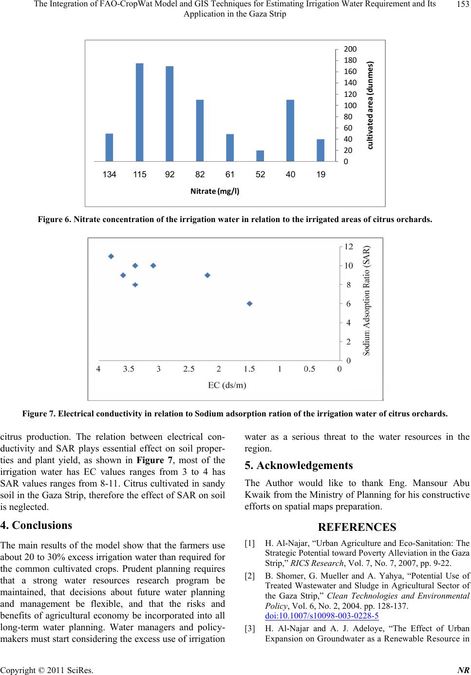
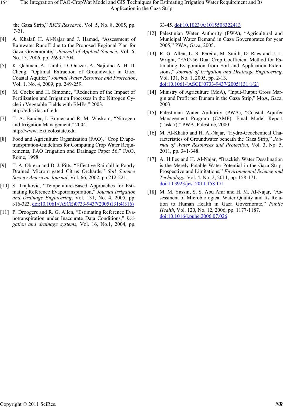
For qualitative study, collected samples from irrigation
wells of the visited farms were analyzed for major
cations such as, Ca and Mg by Titration,
a by Flame
photometer; to estimate the Sodium Adsorption Ratio
(SAR). Anions such as, by Titration, EC is deter-
mined using electrode. The study relied on transactions
descriptive statistics such as average, standard deviation,
correlation by using the statistical program SPSS v.15,
Excel 2007 in the analysis.
Cl
3. Results and Discussions
As shown in Figure 1. Gaza Strip has eight meteoro-
logical stations, an average of ten years for maximum
and minimum temperature, humidity, wind speed and sun
shine hours were inputs for the FAO-CropWat model
(Table 1). The maximum temperature ranges between
18.1 and 29.4˚C, while the mini mum temp erature ranges
between 10.7 and 24.6 in winter and summer, respec-
tively. The average humidity is 68.3% indicating high
humidity in summer than in winter, as the Gaza Strip
located on a coastal zone. Wind speed ranges between
230 and 281 km/d. while the average sun shine hours are
5.7 and 9.7 hours/d in winter and summer, respectively.
The model outputs such as solar radiation and refer-
ence evapotranspiration indicates high variation between
winter and summer, the average solar radiation ranges
from 8.5 to 25.6 MJ/m2/d in winter and summer, respec-
tively as a consequence the reference evapotranspiration
accounts for 1.8 mm/d in February and 5.7 mm/d in July.
For the Gaza Strip limited data sources as the mete-
orological data is well documented in the last decade
only, such model produce satisfactory values compared
to other approaches; Slavisa Trajkovic, 2005 [10] from
Serbia (Southeast Europe) examined whether it is possi-
ble to attain the reliable estimates of ET0 only on the ba-
sis of the temperature data. His goal was reached by the
evaluation of the reliability of four temperature-based
approaches (radial basis function (RBF) network, Thorn-
thwaite, Hargreaves, and reduced set Penman-Monteith
methods) as compareed to the FAO-56 Penman-Monteith
(PM) method. The study showed the Thornthwaite, Har-
greaves, and reduced set Penman-Monteith methods
mostly underestimated or overestimated ET0 obtained by
the FAO-56 PM method. In addition, reference evapo-
transpiration (ET0) estimates have been computed on a
global scale using a high-resolution monthly climate
dataset. Penman-Monteith (PM) and Hargreaves (HG)
methods have been compared, showing very reasonable
agreement between the two methods and proved ET0 es-
timates significantly for arid regions [11].
Copyright © 2011 SciRes. NR