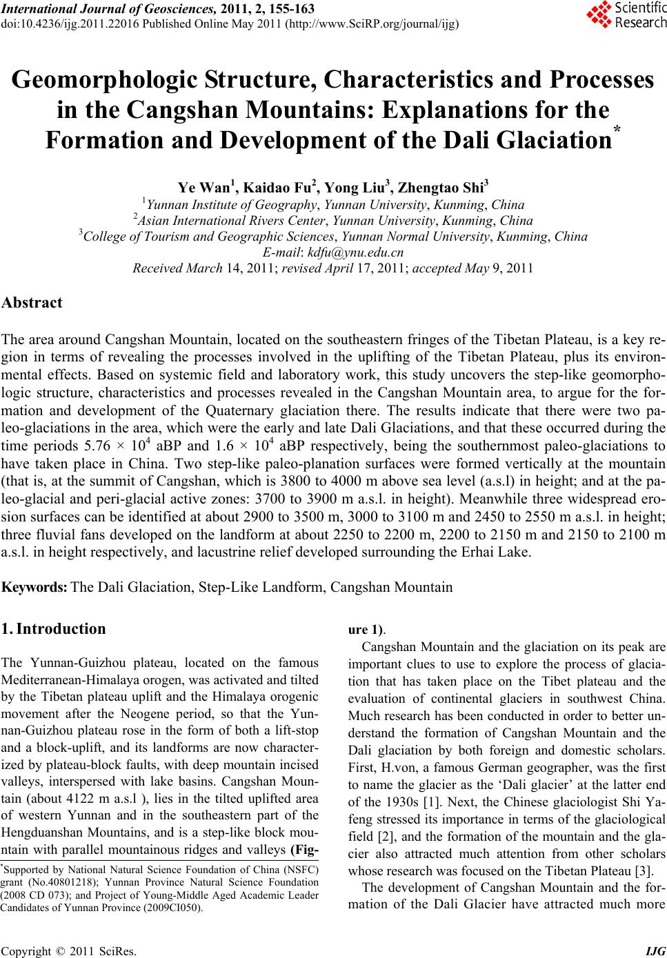
 International Journal of Geosciences, 2011, 2, 155-163 doi:10.4236/ijg.2011.22016 Published Online May 2011 (http://www.SciRP.org/journal/ijg) Copyright © 2011 SciRes. IJG Geomorphologic Structure, Characteristics and Processes in the Cangshan Mountains: Explanations for the Formation and Development of the Dali Glaciation* Ye Wan1, Kaidao Fu2, Yong Liu3, Zhengtao Shi3 1Yunnan Institute o f Geography, Yunnan University, Kunming, Ch ina 2Asian International Rivers Center, Yunnan University, Ku nming, China 3College of Tourism and Geographic Sciences, Yunnan Normal University, Kunming, China E-mail: kdfu@ynu.edu.cn Received March 14 , 20 1 1; revised April 17, 2011; accepted May 9, 2011 Abstract The area around Cangshan Mountain, located on the southeastern fringes of the Tibetan Plateau, is a key re- gion in terms of revealing the processes involved in the uplifting of the Tibetan Plateau, plus its environ- mental effects. Based on systemic field and laboratory work, this study uncovers the step-like geomorpho- logic structure, characteristics and processes revealed in the Cangshan Mountain area, to argue for the for- mation and development of the Quaternary glaciation there. The results indicate that there were two pa- leo-glaciations in the area, which were the early and late Dali Glaciations, and that these occurred during the time periods 5.76 × 10⁴ aBP and 1.6 × 10⁴ aBP respectively, being the southernmost paleo-glaciations to have taken place in China. Two step-like paleo-planation surfaces were formed vertically at the mountain (that is, at the summit of Cangshan, which is 3800 to 4000 m above sea level (a.s.l) in height; and at the pa- leo-glacial and peri-glacial active zones: 3700 to 3900 m a.s.l. in height). Meanwhile three widespread ero- sion surfaces can be identified at about 2900 to 3500 m, 3000 to 3100 m and 2450 to 2550 m a.s.l. in height; three fluvial fans developed on the landform at about 2250 to 2200 m, 2200 to 2150 m and 2150 to 2100 m a.s.l. in height respectively, and lacustrine relief developed surrounding the Erhai Lake. Keywords: The Dali Glaciation, Step-Like Landform, Cangshan Mountain 1. Introduction The Yunnan-Guizhou plateau, located on the famous Mediterranean-Himalaya orogen, was activated and tilted by the Tibetan plateau uplift and the Himalaya orogenic movement after the Neogene period, so that the Yun- nan-Guizhou plateau rose in the form of both a lift-stop and a block-uplift, and its landforms are now character- ized by plateau-block faults, with deep mountain incised valleys, interspersed with lake basins. Cangshan Moun- tain (about 4122 m a.s.l ), lies in the tilted uplifted area of western Yunnan and in the southeastern part of the Hengduanshan Mountains, and is a step-like block mou- ntain with parallel mountainous ridges and valleys (Fig- ure 1). Cangshan Mountain and the glaciation on its peak are important clues to use to explore the process of glacia- tion that has taken place on the Tibet plateau and the evaluation of continental glaciers in southwest China. Much research has been conducted in order to better un- derstand the formation of Cangshan Mountain and the Dali glaciation by both foreign and domestic scholars. First, H.von, a famous German geographer, was the first to name the glacier as the ‘Dali glacier’ at the latter end of the 1930s [1]. Next, the Chinese glaciologist Shi Ya- feng stressed its importance in terms of the glaciological field [2], and the formation of the mountain and the gla- cier also attracted much attention from other scholars whose research was focused on the Tibetan Plateau [3]. *Supported by National Natural Science Foundation of China (NSFC) grant (No.40801218); Yunnan Province Natural Science Foundation (2008 CD 073); and Project of Young-Middle Aged Academic Leader Candidates of Yunnan Province (2009 CI050). The development of Cangshan Mountain and the for- mation of the Dali Glacier have attracted much more  Y. WAN ET AL. 156 Figure 1. The background of geology of the Cangsha n M ountain. attention from geomorphologists and geologists world- wide since the 1970s. L.V. Loczy, a famous Hungarian scholar, explored Yunnan via southern Tibet and western Sichuan early in the last century, investigating the glacial landscape and the distribution of the moraines [4]. A British scientist named F. K. Ward devoted his time to exploring the development of the glacier and river val- leys in the Three Parallel Rivers region, located in northwest Yunnan Province, focusing many of his re- ports on this issue after 1913 [4]. J. Coggin Brown car- ried out an extensive survey on the geological and geo- morphological background of the Yunnan plateau, in particular observing the geomorphology of the Dali area [4]. Meanwhile, Gregory spent his time observing the geological setting in northwest Yunnan, and a more de- tailed scientific expedition was carried out by W. Cred- ner in his “Report of a Yunnan Geographic Expedition” in 1930 [4]. Credner’s results were published in Natural Science and suggested that the Xima pool (a small, cir- cular lake) at the Zhonghe summit is a cirque lake [5]. In the late 1930s, H. Von Wissman referred to the glacia- tion at Cangshan and Yulongshan Mountains many times in his publications, in particular The Pleistocene Glacia- tion of Chin a, and as a result put forward the concept of a Dali Glaciation [2,5]. Mitch investigated Yunnan from 1940 to 1947 and wrote the books: A Geological Survey of Yunnan and The Tectonic history of Yunnan and Ge- ology of Lijiang [6]. At the same time, Feng Jinlan, a Chinese scholar, provided his understanding of the evo- lution of the landforms, geomorphology and physiogra- phy in the region [7]. Later, Chen Fubin studied the Qu- aternary accumulation, the geomorphology and neo- tec- tonic activity around Cangshan and Yulongshan Moun- tains [8]. It is important to review and confirm the facts regard- ing the formation and evolution of Cangshan Mountain and the Dali glacier by going through the contrasting research work in other regions, and the results of this review will help give important clues as to the climatic effects caused by the Tibetan uplift [9]. As a result, our research work has included systemic field and laboratory work, in order to gain more intelligence on this issue since the mid to late 1990s. 2. The Vertical Geomorphic Structure and Characteristics of Cangshan Mountain 2.1. Paleoplanation Surfaces The paleoplanation surfaces, formed in the Paleogene period, are from an uplifted peneplain which is low in gradient and scattered across the mountainous and pla- teau ar eas in cent ral an d wester n China, bu t is distr ibuted continuously around the Tibetan Plateau [10,11]. Ac- cording to the research by Li et al. [12], the main plana- tion surface on the Tibetan Plateau was formed at about 1000 m a.s.l. during the Pliocene and late cenozioc peri- ods. The present surface, at about 4500 m, is the best preserved planation surface in China, and this extends from the Tibetan Plateau and northern Hengduanshan Mountains, to Lijiang and Dali in western Yunnan at a height of aroun d 4500 m, falling to ab out 2000 m around the Kunming region in the central Yunnan-Guizhou Pla- teau. This hierarchy landform indicates that ancient tec- tonic activity was widely associated with neo-tectonic action in the region. From the mountain summit to the river valley, there are glaciers, lake basins and fluvial landscapes. The plateau surface has been dissected with Copyright © 2011 SciRes. IJG  Y. WAN ET AL.157 alternating mountain ranges and valleys in northwest Yunnan, due to the block-fault uplifts of the mountains and the deep incisions of the rivers. At present, the sum- mit surface in Yulongshan is between 5000 and 5200 m in height and at Cangshan, it is 3750 to 4000 m in height, these being the remnants of the highest paleoplanation surface (Figure 2). Jianchuan red clay, which is mainly distributed around the Dali and Lijiang regions, was formed during the late Tertiary period, and is contempo- raneous with the Panzhihua red clay which developed in the southwest Sichuan basin. In contrast to the Jianchuan clay stratum, an ancient peneplain developed in the Dali basin surrounding the Erhai Lake, where thick Songma- opo formations were deposited above the peneplain and developed into lacustrine sediment. In accordance with previous research, the bottom of the Songmaopo Forma- tion dates from 330 × 104 aBP, during the beginning of the dissection of the Dali planation surface and block-fault uplift of Cangshan Mountain. At the same time, Erhai Lake started to develop, and Cangshan Mountain was up lifted from 700 m a .s.l. to 4000 m a.s.l . - its present position. The mountain range has therefore been lifted about 3300 m since 330 × 104 aBP, to become the highest planation surface in the Dali area (Table 1). This planation surface has been eroded by ice and wa- ter, so the remnants are revealed in the form of alternat- ing mountain ranges and valleys, with thin modern gla- ciers over the top. As a result glacial rock, gelifluction and frost heaving hillocks can be investigated on the surface. 2.2. The Cold Geomorphic Process and the Paleoglacial a nd Peri g la c ia l Z on e Cangshan Mountain is located in a subtropical zone, where it rains broadly in the summer and autumn under the influence of the southeast Pacific monsoon and the Indian Ocean’s warm and humid climate. The land, tem- perature and snowfall conditions all help in the devel- opment of glaciers in these high-elevation moun tains. At a height of 3700 to 3900 m, the dominant paleoglacial, periglacial and modern fluvial processes are active (Fig- ure 2). Incision by fluvial processes, frost weathering, and collapse and block movements, are the main external geomorphologic processes that take place in the Cang- shan Mountain area. The rock strata are mainly com- posed of Precambrian metamorphic rock, which consti- tutes the core of the mountain and is overlaid by a thin layer of weathered rocks and sub-high mountainous meadow soil. Ren Meie et al. [13] and Shi Ya- feng et al. [14,15] argued that the snowline for the last glaciation in Dali was 3900 m. The oceanic climate has been more helpful in the development of glaciers than the continen- tal climate; therefore, it is possible that the last glacial snowline at Cangshan Mountain would have dropped about 100 to 150 m to reach a height of 3800 to 3750 m. Based on this research; however, the eastern slope of Cangshan Mountain appears to be steeper than the west- ern slope, and through the use of aerial photographs, 65 cirques have been identified on Cangshan Mountain, plus three glacial lakes, two glacial basins and six nivation hollows. These are distributed between Wutai summit in the northern part of the Mountain and Sh engying summit , in t h e so u th e rn part - between Yingle summit and Malong summit. There are 47 cirques on the eastern slopes of Cangshan Mountain, and eighteen on the western slopes [16], the greater number in the east due to differences in landforms and precipitation. First, in terms of the relief structure of Cangshan Mountain, the eastern slope is steeper, so there are more horns and arêtes, plus, inter- estingly, there are erosion roofs distributed near the fault cliffs, formed by glacial and periglacial processes, Figure 2. The profile map of vertical geomorphologic de- velopment of the eastern slope in the Cangshan Mountain. Table 1. The stratum structure and the extent of the planation surfaces in the Dali and Lijiang areas. Region Stratum Age (Ma) Height of the Paleoplanation Surface (M a.s.l.) Height of the Remaining Planation Surfaces (M a.s.l) Uplifted Height (m) Dali Area Paleoplanation surface-Songmaopo lacustrine sediment-Jianchuan red clay 330 700 4000 3300 Lijiang Area Paleoplanation surface-Songmaopo lacustrine sediment-Jianchuan red clay 330 700 5000 4300 Copyright © 2011 SciRes. IJG  Y. WAN ET AL. Copyright © 2011 SciRes. IJG 158 and these landforms facilitate the formation of cirque gla- ciers. Secondly, although Cangshan Mountain is high and has an almost north-south alignment, it is not long enough to block the water vapor from crossing from one side of the mountain to the other, something which is very different from the other mountains in the area, such as Yulong Mountain and Haba Mountian, where precipi- tation on the western slope is greater than on the eastern slope. When water vapor moves across to the eastern slope, it is uplifted by the Erhai cold anticyclone , leading to greater precipitation on the eastern slope. Annual pre- cipitation is 1081 mm at Yangbi weather station on the western slope, is 1078 mm in Dali town, on the eastern slope, and is 1052 mm in Xiaguan [17]. The data indi- cates that precipitation on the eastern and western slopes is almost equal statistically, showing the special n a ture of the local rainfall, which is caused by Cangshan’s geo- morphic structure being dominated by the south-western monsoon. The particular landform and precipitation has resulted in more cirques developing on the eastern slope than on the western slope. Our knowledge of glacier characteristics [2,5], as well as the detailed field and in- door work carried out, proves that the development of glacial erosion landforms in the study area mostly took the form of cirques, and that the paleoglacier which de- veloped on Cangshan Mountain can basically be charac- terized as a hanging oceanic cirque glacier. Through surveys it has been established that the ancient cirques are distributed in two tiers along the two sides of the ridge, and the height of the higher tier of cirques is at about 3800 to 3950 m, and the lower tier is at about 3800 to 3850 m, with the length and width of the cirques being about 250 to 400 m and 300 to 500 m, respectively (Ta- ble 2). The Lanfeng cirque is the most typical, as, located at about 3900 m there are obvious anti-slope and cross- walls at the bottom of the cirque, the length and width of both being 500 m. Able to be seen clearly from Xizhou, a town on the shores of Lake Erhai, two cirque lakes, Hu- anglong pool at about 3880 m and Heilong pool at about 3850 m, developed between Lanfeng and Sanyangfeng summits (Table 2). Lanfeng peak is a typical arête, with a huge-filled stone glacier having developed at the back wall, and with periglacial sediment deposited at the bot- tom of the cirque. Another typical cirque is Ximatan pool, located on Yuju summit and at a height of abou t 3840m, where there are debris slopes, stone-filled glaciers and frost hillocks at the back wall of the cirque. The round lake referred to by Credner, Wissmann and Feng Jinglan, is actually the Ximatan cirque [2,5,7], which has been preserved well in terms of its shape and has not been incised by fluviation. The ESR age of the sediment at Shuangtangzi cirque is 1.6 × 10⁴ aBP [16,18], and is deemed to have been formed during the late of Dali ice epoch of the Pleistocene period. At that time, seven cir- ques were formed and most of them are distributed to the east of the mountain, and are associated with six nivation hollows. Based on field survey, three types of periglacial were found on the Cangshan Mountain. Debris slopes, stone- filled glaciers mainly formed within the cold geomor- phologic active zone where elevation is above 3700 m. The slopes and stone-filled glaciers are about 10 – 20 m long, and the about 50 - 80 m wide. Most distribute on summits with altitude above 4000 m, such as Malong summit, Lanfeng summit, Sanyang summit, Yuju summit and Longquan summit. Frozen expanded hillocks with the diameter around 50 - 70 cm and height about 20 - 30 cm, mainly distributed on the ridge between two pe aks where the Paleoplanation surface lies. Periglacial ves- tiges found in eastern slope of Cangshan Mountain are- more than those in western slope. We argue that the condi- tion of landform, precipitation and temperature in eastern Table 2. Parameters and characteristics of the glacial landforms. Period Number of Cirques Shape of Glacial Landforms Altitude of Glacial Landforms (m)ESR Age Glacier Properties Glacial Process Development Location of Typical Glacial Landforms Paleo-glacial Landforms on the Upper Tiers Seven cirques, six nivation hollows, horn-peaks and aretes Length is 250 to 400 m, width is 300 to 500 m 3800 to 3950 m1.6 × 104 aBP Belong to the hanging oceanic cirque glacier More typical glacial morphology and with few remains left by recent fluvial action Ximatan pool - elevation is 3840 m. Shuangtanzi pool - elevation is 3850 m at Yujufeng peak Paleo-glacial Landforms on the Lower Tiers Twenty more typical cirques (anti-slopes and crosswalls) distributed along two sides of the mountain ridge Length is 250 to 300 m, width is 500 to 750 m 3600 to 3850 m5.76 × 104 aBP Hanging oceanic cirque glacier (including short ice tongue glaciers) Relatively obvious recent fluvial action and paleoglacial reliefs innovated by fluvial processes Hanglongtan pool (elevation is 38 80 m) and Heilongtan pool (elevation is 38 50 m) between Lanfeng peak and Sanyangfeng peak Periglacial Characteristics Debris slopes, stone-filled glaciers and frost hillocks  Y. WAN ET AL. Copyright © 2011 SciRes. IJG 159 slope are more suitable for periglacial geomorphology development. The lower tier of cirques is located between 3700 and 3850 m and is larger in scale, with the lower of these located at 3750 m and with a length of between 250 and 300 m, and a width of between 500 and 750 m (Table 2). A thin layer of sediment has been deposited at the bot- tom of the cirques, which are dominated by plants such as azalea. Most of the cirque crosswalls have been cut into by fluvial incision. A cirque lake formed during the glacial epoch has since shrank and gradually dried up. The Shuanglongtan pool; for example, was caused by backward fluvial incision to the source, and has since turned from one large pool into two smaller ones. Using aerial photography, twenty seven cirques can be ob- served on the eastern slope and three on the western slope. The ESR age of the sediment deposited at the bot- tom of the Yunnong su mmit cirque, which is located at a height of 3600 m, can be dated back to 5.76 × 10⁴ aBP [16,19], at the early stages of the Dali ice epoch. 2.3. Mountainside Fluvial Incision The erosion surface in the area is the planation surface which has been uplifted and dissected on to the earth’s surface [11-12]. There are several pediments on Cang- shan Mountain at a height of between 2400 m and 370 0 m, due to the phased block uplift of the Mountain during the Quaternary period. Field investigations of the erosion surface on the Mountain, have found at least six erosion surfaces at heights of 3600 m, 3100 m, 2800 m, 2600 m, 2500 m and 2400 m. This series of erosion surfaces has been incised by streams on the eastern slope, revealed by alternating erosion surfaces and cliff pools. In general, the conjunction of the surface and cliffs is presented as typical fault triangles at a height of 2800 to 2900 m at Qinglinfeng summit, and about 2900 to 3500 m at Yu- jufeng summit. Two larger erosion surfaces exist at a height of 2450 to 2550 m and at 3000 to 3100 m on the respective summits (Figure 2). The geomorphic processes along the mountain have been dominated by slope flows (waterfall and sheet flows), and the front parts of the erosion surfaces are generally covered with thick residual material, with dif- ferent thicknesses of alluvial and fluvial sediment on both sides of the valley. The sediment is poorly rounded and sorted, which can be mainly attributed to flood gene- sis. 2.4. Mixed Deposition Process Zone on the Pediment Several deposition fans can be found in the fields on the eastern slopes of Cangshan. Based on the structure and composition of the sediment found there, they have been categorized as mixed depositions by researchers, because the sediment does not accord with the characteristics of the other types of sediment found [14,20]. As a result, this study will define and title the piedmont sediment as consisting of mixed deposition fans. There exist three grades of deposition fan which run from an altitude of 2100 m to 2400 m - arranged neatly from south to north. From top to bottom, the heights of the three deposition fans are 2250 to 2200 m, 2200 to 2150 m and 2150 to 2100 m (Table 3). The highest fan meets the pediment, and has sediment covering it in the form of a thrust fault. As one moves from the higher to the lower fan, they grow younger, the gradients become less and the scale smaller. The fan at about 2250 to 2200 m is mainly composed of large boulders, gravel and clay, and is poorly sorted, with long term deposits and is intensively clayizated. This fan has been incised by water and severely damaged, so that it is now contains non-continuou s ridges and hills. The texture and sediment characteristics of the fan dem- onstrate that chiefly the d ynamics of fan deposition have taken place, with debris and water-rock flows present (Table 3). The fan situated at a height of 2200 to 2150 m is cha- racterized by considerable sorting and layer features, and the South Baolin section can be used as an example. This section is about 8.5 m in depth, with the upper layer be- ing about 2 m deep and covered by a layer of grey mixed deposits, of which th e scree sh ow s as poorly ro und ed an d sorted stones with diameters ranging from 10 to 50 cm. The middle layer of 1.5 m is composed of fine red gr avel and has clear evidence of boulders between the upper and middle layers. The upper part, with a thickness of 20 to 40 cm is paleosoil, with clear eluviation. The lower layer of about 5 m is made of granite and balling boul- ders, produced by weathered limestone. Generally, the rocks in the low layer are 50 to 80 cm in diameter, though some of them exceed 1m. This fan is preserved better than the previous one mentioned. Neolithic ruins left by humans, aged about 3000 aBP, and a Bronze Age burial site from before 2000 aBP, can also be found in the mixed deposits in the fan. The fan is considered to have been produced by alluvial and fluvial processes (Table 3). The fan located between 2150 and 2100 m is distrib- uted continuously along the foot of Cangshan, running from north to south, and is covered mainly by farmland and residential districts. The ruins of the ancient city of Nanzhao, from before 1000 aBP, are located within this fan as well. Most of the component materials are sands, ine sands and clay, within which are some large boul- f  Y. WAN ET AL. Copyright © 2011 SciRes. IJG 160 Table 3. The structure and genesis of the three deposit fans. Fans Altitude/m Characteristics Composition Genesis First Class Fan 2250 - 2200 Connecting with the pediment and with an early relative age; distributed non-continuously due to water flow incisions during the post- glacial period. Composed of huge boulders, gravel and clay; clay weathering action is strong. Slope accumulation is do- minant and pluvial depo- sits are secondary. Second Class Fan 2200 - 2150 Connected to the first class fan plus the surface layer is composed of rocks (boulder clays with a diameter of about 10-15 cm); has a poor de- gree of rounding and a poorly developed sorted action; also the middle layer of the profile is about 1.5 m. Has one fine gravel accumulation area. Where there is an obvious dividing layer at between 20 to 40 cm, plus obvious e luviation – can be considered as one paleopsoil layer. The middle layer of the profile is about 1.5 m. Has one fine gravel accumulation area where there is an obvious dividing layer at between 20 and 40 cm., plus there is obvious eluviation - can be considered one paleopsoil layer. Debris flows; water flow; pluvial deposits. Third Class Fan 2150 - 2100 The relief shape of this fan is preserved better than for the second class fan, and reveals con- tinuous distribution along the Cangshan moun- tain pediment. There is better classified action and finer layer structures than in the other classes of fan; is composed of sand, fine sand and clay plus there are a few boulders and huge rocks present. The profil e shows that the pluvial process is domi- nant and fluvial process is secondary. An obvious characteris- tic is that it has transited forward under the coas- tal deposit process. ders and gravels. Due to an interaction between mountain streams and the lakeshore zone, the geomorphology has fluvial, alluvial and lacustrine characteristics. In accor- dance with the structure and the origins of the fan, a ge- morphologic transition from a proluvial, alluvial fan to a coastal plain can be iden tified (Table 3). As Cangshan Moun tain was up lifted d ramatically after the Quaternary period, a time associated with frequent seismic activity, debris and erosion terrain of glaciers was formed on the mountain peak, but the corr esponding and typical moraine sediment has not yet been found. However, huge stones with a diameter of 3 to 5 m are disseminated along the highway in Dali city, and have been identified as ancient glacial boulders. A large area of sediments, to the east of Santa Temple, ranging from 3 m to several millimeters in diameter, may have been the product of debris flow. The fan-shaped depositions at the bayou of 18 streams, character ized by roughly sorted and assembled pebbles, are deemed to be fluvial and alluvial sediments. This mixed deposition was formed by an in- teraction of ice boulders, ancient and modern debris flows, alluvial, proluvial and lacustrine processes, and other external forces. The varying dominant forces on the landform have resulted in specific materials and compo- nents appearing in the sediments; meanwhile, the giant stones distributed at the foot of the mountain are the product of storm debris flows, or may have been pro- duced by weathering and other flow processes. The fine and middle grain sized materials within the debris flow deposition have been remov ed by the stream, so the g iant stones stand alone and are a major landscape feature near to Dali town (Figure 3). 2.5. Human-Related Geomorphic Structures on the Lake Plain and Lakeshore Terraces Following the deposition of the three mixed fans, the area was dominated by the Erhai Lake Plain at a height of between 2100 to 1900 m and a width of about 1 to 3 km. Settlements such as Dali and Xizhou developed during the Yuan Dynasty on the lakeshore plain, which indicates that the coastal plain was formed 700 to 800 years ago. The coastal plain sediment is about 10 to 20 m thick and contains greyish-yellow clay, compressed with gravel, grass and coal. Based on field observations, four terraces have been identified at the eastern foot of Cang- shan Mountain. The fourth terrace, which is 2 m higher than the water level of the lake, has been identified as a basement terrace and is composed of fine lacustrine sand and peat soil, but the other three are all accumulation terraces. The height above the lake water level of these three terraces is 10 m, 15 to 30 m and 40 to 80 m respec- tively, and they are covered by Lacustrine, alluvial and proluvial sediments from the bottom to the top. The ter- races were all formed during the Holocene period and are closely related to local human activities. As the water level in Erhai Lake dropped and the coastal terraces up- lifted each time, so human activities and the cultural landscape, including residential areas, farmland and roads, expanded in the direction of the Lake. This fact has also been proved by archaeological findings [21], which indicate that New Stone Age ruins from before  Y. WAN ET AL.161 Figure 3. Map differentiating the geomorphologic struc- tures and process classifications at Cangshan Mountain and its adjacent mountain, in Yunnan Province. 3000 aBP and Bronze Age burial mounds from before 2000 aBP existed on the third terrace, but then the ruins of Nanzhao from about 1000 aBP moved to the lower second terrace, and settlements from the Yuan and Ming Dynasties then moved to the second terrace. This is a cultural landscape pattern created b y humans adapting to changes in the natural environment, and in order to take full advantage of it. A profile map of the vertical geomorpholoical devel- opment of the eastern slope of Cangshan Mountain is shown in Figure 2. A typical inland plateau lakeshore erosion landscape has formed on the eastern shore of Erhai Lake, instead of on the plain, with capes, bays and eroded cliffs distributed from east to west along the banks of the lake. The relative height from the top of the cliff to the lake water level is from 100 m to 150 m, and the cliff extends for more than 30 kilometers, making up a unique coastal landscape. The lake’s bays are the best places for building and for settlements; Wase and Hai- dong towns are situated in bays. In addition, Luoquan Temple and Wenbi tower are located at the most promi- nent cape on the lake, near Haidong Town. These reli- gious buildings and local residences are scattered across the landscape, and these reveal the context of the local culture. There are two isolated islands near Haidong Town and Wase Lake bay: Jinsuo Island and Xiaoputuo Island, where people from the Bai ethnic group exhibit their culture and religion. In short, the eastern shore area is a special place, with an historical cultural landscape which includes a combination of lake-eroded landforms, the culture of the Bai ethnic group and local religious constructions. 3. Geomorphologic Characteristics Surrounding Cangshan Mountain The Haidong Mountain s, to the east of Erhai Lake, are a series of small mountains and hills shaped by fluvial process. The rocks in the area are composed mainly of Ordovician shale and sandstone, Silurian limestone and shale, Carboniferous limestone and Permian basalt. The area near Erhai Lake is dominated b y small hills 2100 to 2600 m in height, formed by water erosion. The strata incline to west, thus building the formation of the Cang- shan block as a small anticline, with th e Erhai depression as a large syncline. The higher surface, at about 2400 to 2600 m in height, is a larger, more continuous peneplain which represents the remnants of an ancient planation surface, and the relief on the planation surface divides the Erhai and Binchuan Basins, and this has moved to the west due to gradual westwards erosion of the Binchuan River. The water level of Erhai Lake (at 1900 m) is 300 m higher than the average altitude of Binchuan Basin, so this topography has been used to divert water from Erhai to Binchuan since the 1990s (Figure 3). Huadian Basin is located between the Cangshan, Yan- jing, Yunnong and Canglang summits, and extends from 35 km from the north-west to the south-east, at an alti- tude of about 3000 - 3300 m; at the conjunction of the Erhai Lake Basin and the Eryuan Basin. The basin has an anisomerous shape, the southwest slope is gentle with a long, extended alluvial deposition fan, while the north- east slope is steeper with no fan deposition. Most of the rivers’ sources are in the southwestern mountains and flow to the northeast. There is very thick Quaternary sediment in the Huadian basin, which is a fault con- trolled graben valley; the thick, loose Quaternary depos- its are alluvial and there is slope deposition on the west- ern slope. This sediment was produced by glacial me- chanical weathering and freeze-thaw mud flow processes. The fan was formed and continues to be formed by water flowing along the western slopes of the valley, so the course of the rivers there are gradually moving west- wards. The landforms in the Huadian basin have been Copyright © 2011 SciRes. IJG  Y. WAN ET AL. 162 created by river capture between the Huadian River and Fengyu River, and this river capture process is still in progress today (Figure 3). 4. Discussions The glacial erosion geomorphology at different altitudes is proof of the division in glaciation processes between the Lijiang and Dali ice ages. The Dali glacial cirque, crosswall and short-valley were originally distributed between about 3750 and 3900 m. In the absence of gla- cial deposit landforms, glacial landforms as represented by the erosion cirques should be evidence of the exis- tence of a Dali Ice Age. The cirque lake at Luoping Mountain was originally distributed regularly along the both sides of the main ridges. Shaped by water erosion and other external forces over a long period, the area reveals mixed rounded peaks and beams, and hilly areas like the landscape on China’s the Loess Plateau. The ancient glaciers were formed at an elevation of 2900 to 3200 m, about 750 to 800 m lower than the Dali Glacia- tion snow line, and earlier than the Dali Ice Age at Cangshan Mountain. The u-shaped valley which extends forward for three kilometers, and the obvious lateral mo- raine, should be evidence of the existence of the Lijiang Ice Age. As a result, there is not only evidence for the well-known scientific concept of a Dali glaciation in the Cangshan area, but also an earlier Late Pleistocene glaci- ation - the penultimate glaciation, known to us as the Lijiang Ice Age in the Dali area. The altitude of Cangsh an Mountain is higher than that of Luoping Mountain, but glacial erosion and deposi- tional geomorphology earlier than the Dali Ice Age has not been found at Cangshan, so it cannot be determined whether or not there was a penultimate glaciation at Cangshan. All these facts have therefore created a mys- tery in the field of Qu aternary glacial research; an incen- tive to promote the continuation of scientific work to explore this area. 5. Conclusions The landforms in the area of Cangshan and Erhai Lake are characterized by diverse compositions on a multiple level, with fusions in the lan dscape. Though the region is small, the landform types are comprehensive, complex and changeable. There is a disaggregation of the Paleo- planation surface, lacustrine depositions on the western shores of the lake and erosion cliffs on the eastern shore; plus river terraces and evidence of mountainous glacial and periglacial processes. There is no doubt that Cang- shan Mountain is the best place to research geomorphol- ogy and neo-tectonic movements in the region. The summit of Cangshan is at a height of 3700 m, a remnant of the paleoplanation surface, and its develop- ment was contemporaneous with Yulong Snow Moun- tain, at about 5000 m in height in Lijiang, as well as the surface of the Tibetan Plateau - at about 4500 m. There have been two glaciations on Cangshan Moun- tain, and there is evidence of glacial and periglacial processes having taken place in the area above 3500 m, during the process of the uplift of the mountain. The scale of the two glaciations can be identified by the quantity, scale, distribution and height of the cirques, an d their ages are 5.76 × 10⁴ aBP and 1.6 × 10⁴ aBP, respec- tively. There are three large erosion surfaces on Cangshan Mountain, which were formed by the ph ased uplift of the mountain. Three mixed deposition fans were formed on the eastern slope of the mountain, which are composed of debris flows, water-rock flows; fluvial, alluvial and slope depositions. The mountainous area of east Erhai is the remnant of a planation surface at about 2500 m, which is the b est pre- served planation surface in the Dali area. This is of great significance for the research of neo-tectonic movements in the western Yunnan block, and the Huadian basin was formed by the regional fault at the mountain. Thick and loose Quaternary sediments were deposited in the basin, and since that time, river capture has been the ongoing geomorphologic process to have influenced landform evolution in the basin. The Dali glaciation and Cangshan Mountain are very important subjects to research in terms of the environ- ment and glacial geology in the area, and our research offers a further level of understanding on the relationship between the evolution of landforms and glaciers in the area around Cangshan Mountain, through the field and laboratory work we carried out based on former studies [22-23]. 6. References [1] Z. W. Cheng and W. Ye. “The Necessity and Emergency of Study on Yunnan Dali Glaciation,” Yunnan Geo- graphic Environment Research, Vol. 5, No. 2, 1993, pp. 84-85. [2] H. V. Wissmann, “The Pleistocene Glaciation of China,” Bulletin of the Geological Society of China, Vol. 17, No. 2, 2007, pp. 145-168. doi:10.1111/j.1755-6724.1937.mp17002002.x [3] J. J. Li “The Thesis Atlas of Academician—The Uplift of Tibet Plateau and Environmental Changes of Asia,” Sci- ence Press, Beijing, 2006, pp. 1-200. [4] W. C. Zhao, “Study on the Geomorphic System of Yun- nan,” Yunnan Geographic Environment Research, Vol. 10, Supplement, 1998, pp. 47-55. Copyright © 2011 SciRes. IJG  Y. WAN ET AL. Copyright © 2011 SciRes. IJG 163 [5] W. Credner, “The Expedition Report of Yunnan Geogra- phy in 1930,” Natural Science, Vol. 3, No. 4, 1932, pp. 593-662. [6] Bureau of Geology and Mineral Resources of Yunnan Province, “Yunnan Province Regional Geological Annals of Yunnan Province,” Geological Press, Beijing, 1990, pp. 1-220. [7] J. L. Feng, “The Physiography of Dali County, Yunnan,” Collected Papers of Geographic Research Institute of Chinese Academy of Sciences, No. 1-2, 1941, pp. 23-56. [8] F. B. Chen, J. L. Chen and Y. F. Xu, “The Analysis of Neotectonics of Quaternary Accumulation and Layer La- ndforms in Yulongxueshan–Cangshan Areas,” Acta Geo- graphic Sinica, Vol. 47, No. 5, 1992, pp. 431-440. [9] J. J. Li, Q. Shu, S. Z. Zhou, et al., “Review and Prospects of Quaternary Glaciation Research in China,” Journal of Glaciology and Geocryology, Vol. 26, No. 3, 2004, pp. 235-243. [10] Chengdu Geographic Institute of Chinese Academy of Sciences, “Geographic Information of Hengduanshan Mountianous Area—Geomorphological Part,” Research Report, 1980, pp. 14-26. [11] P. H. Huang, “Discussing the Geomorphological Re- search on Yunnan,” Quaternaria Sinica, Vol. 3, No. 1, 1960, pp. 10-17. [12] J. J. Li, S. X. Wen and Q. S. Zhang, “A Discussion on Ages, Extents and Forms of the Upheavalling of Qinhai Xizang Plateau,” Science in China, No. 6, 1976, pp. 608- 616. [13] M. Ren, et al., “A Primary Study on of Lijiang and Yu- longshan Mountain,” Yunnan University Transaction (Natural Science), No. 4, 1957, pp. 9-18. [14] Y. F. Shi, et al., “Problems of Quaternary Glaciers and Environment in East China,” Science Press, Beijing, 1989, pp. 106-107. [15] Y. F. Shi, “A Suggestion to Improve the Chronology of Quaternary Glaciations in China,” Journal of Glaciology and Geocryology, Vol. 24, No. 6, 2002, pp. 687-692. [16] Q. L. Chen and W. C. Zhao, “Aerial Images Observation of Glacial Landforms at Cangshan Mountain, Dali, Yun- nan,” Yunnan Geographic Environment Research, Vol. 9, No. 2, 1997, pp. 66-73. [17] Y. Feng and D. M. He, “The Precipitation Characteristics and Water Resources Utilization in High Mountain and Deep Gorge Area in Northwest Yunnan Province,” Yun- nan Geographic Environment Research, Vol. 9, No. 1, 1997, pp. 40-47. [18] M. S. Kuang and W. C. Zhao, “Study on ESR Dating of Depositional Stratums of Late Pleistocene Epoch in Cangshan Mountain, Dali Area, Yunnan Province,” Yun- nan Geographic Environment Research, Vol. 9, No. 1, 1997, pp. 49-57. [19] S. Z. Zhou and J. J. Li, “New Dating Results of Quater- nary Glaciations in China,” Journal of Glaciology and Geocryology, Vol. 25, No. 6, 2003, pp. 660-666. [20] R. F. Flint, “Glacial and Quaternary Geology,” John Wi- ley Press, New York, 1971, p. 423. [21] Z. Q. Zhang, “A Study on the Relationship between Re- gional Earthquake and Modern Tectonics Movement,” Seismology and Seismological Archaeology, Cultural Re lic Press, Beijing, 1977, pp. 109-130. [22] Glaciology and Geocrology Institute, Chinese Academy of Sciences, “The Outline of Chinese Glaciers,” Science Press, Beijing, 1988, pp. 1-186. [23] Y. F. Shi and Z. C. Xie, “The Basic Characteristics of Modern Glacier of China,” Acta Geographic Sinica, Vol. 30, No. 3, 1964, pp. 183-208.
|